Bridge Statistics for Rosemount, Minnesota (MN)
Condition, Traffic, Stress, Structural Evaluation, Project Costs
- National Bridge Inventory (NBI) Statistics
- 10Number of bridges
- 131ft / 40.3mTotal length
- $1,000Total costs
- 121,758Total average daily traffic
- 9,973Total average daily truck traffic
- National Bridge Inventory (NBI) Registered Bridges for Rosemount
- No street view available for this location
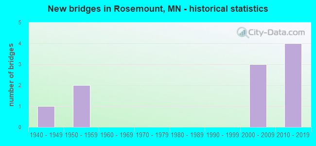
- New bridges - historical statistics
- 11940-1949
- 21950-1959
- 32000-2009
- 42010-2019


- Bridge Condition - Deck
- 28.6%Very good
- 57.1%Good
- 14.3%Fair

- Bridge Condition - Superstructure
- 57.1%Very good
- 28.6%Good
- 14.3%Poor

- Bridge Condition - Substructure
- 14.3%Very good
- 28.6%Good
- 42.9%Satisfactory
- 14.3%Fair
Find on map >> Show street view
Structure Number: 19005, Location: 1.8 MI S OF S JCT TH 55 (Lat: 44.739047, Lng: -93.035028), Route carried "on" structure: US 52, Year Built: 2017, Status: Open, Structure Length: 5.81m (19.06ft), Average Daily Traffic: 15,750 (year 2015), Truck Traffic: 9%, Average Future Daily Traffic: 15,750 (year 2039), Design Load: HL 93, Features Intersected: CSAH 42
Minimum Vertical Clearance: 30+ m (98+ ft), Kilometerpoint: 0.000, Lanes on structure: 2, Lanes under structure: 2, Base Highway Network: Yes, Owner: State Highway Agency, Approaching Roadway Width: 12.8m (42.0ft), Material/Design: Prestressed concrete, Design/Construction: Stringer/Multi-beam, Number Of Spans In Main Unit: 2, Length of Maximum Span: 28.5m (93.5ft), Curb-To-Curb Width: 12.8m (42.0ft), Out-to-Out Width: 13.8m (45.3ft)
Condition: Deck: Very good, Superstructure: Very good, Substructure: Good, Operating Rating: 47.0 metric tons, Method Used To Determine Operating Rating: Load and Resistance Factor Rating (LRFR) rating reported by rating factor(RF) method using HL-93 loadings, Inventory Rating: 36.3 metric tons, Method Used To Determine Inventory Rating: Load and Resistance Factor Rating (LRFR) rating reported by rating factor(RF) method using HL-93 loadings, Structural Evaluation: Better than present minimum criteria, Deck Geometry: Equal to present desirable criteria, Underclear: Equal to present minimum criteria, Approach Roadway Alignment: Equal to present desirable criteria, Designated Inspection Frequency: Every 24 months, Inspection Date: April 2021, Deck Structure Type: Concrete Cast-file-Place, Wearing Surface/Protective System: Wearing Surface: Low Slump Concrete, Deck Protection: Epoxy Coated Reinforcing
Find on map >> Show street view
Structure Number: 19006, Location: 1.8 MI S OF S JCT TH 55 (Lat: 44.739011, Lng: -93.034728), Route carried "on" structure: US 52, Year Built: 2017, Status: Open, Structure Length: 5.81m (19.06ft), Average Daily Traffic: 16,712 (year 2019), Truck Traffic: 9%, Average Future Daily Traffic: 15,750 (year 2039), Design Load: HL 93, Features Intersected: CSAH 42
Minimum Vertical Clearance: 30+ m (98+ ft), Kilometerpoint: 0.000, Lanes on structure: 2, Lanes under structure: 4, Base Highway Network: Yes, Owner: State Highway Agency, Approaching Roadway Width: 12.8m (42.0ft), Material/Design: Prestressed concrete, Design/Construction: Stringer/Multi-beam, Number Of Spans In Main Unit: 2, Length of Maximum Span: 28.5m (93.5ft), Curb-To-Curb Width: 12.8m (42.0ft), Out-to-Out Width: 13.8m (45.3ft)
Condition: Deck: Very good, Superstructure: Very good, Substructure: Good, Operating Rating: 47.0 metric tons, Method Used To Determine Operating Rating: Load and Resistance Factor Rating (LRFR) rating reported by rating factor(RF) method using HL-93 loadings, Inventory Rating: 36.3 metric tons, Method Used To Determine Inventory Rating: Load and Resistance Factor Rating (LRFR) rating reported by rating factor(RF) method using HL-93 loadings, Structural Evaluation: Better than present minimum criteria, Deck Geometry: Equal to present desirable criteria, Underclear: Equal to present minimum criteria, Approach Roadway Alignment: Equal to present desirable criteria, Designated Inspection Frequency: Every 24 months, Inspection Date: April 2021, Deck Structure Type: Concrete Cast-file-Place, Wearing Surface/Protective System: Wearing Surface: Low Slump Concrete, Deck Protection: Epoxy Coated Reinforcing
Find on map >> Show street view
Structure Number: 19557, Location: IN ROSEMOUNT (Lat: 44.746783, Lng: -93.099525), Route carried "on" structure: City street 104, Year Built: 2005, Status: Open, Structure Length: 6.40m (21.00ft), Average Daily Traffic: 2,900 (year 2014), Average Future Daily Traffic: 2,900 (year 2039), Design Load: HL 93, Features Intersected: UP RAIL
Minimum Vertical Clearance: 30+ m (98+ ft), Kilometerpoint: 0.000, Lanes on structure: 2, Owner: City or Municipal Highway Agency, Approaching Roadway Width: 15.9m (52.2ft), Material/Design: Prestressed concrete, Design/Construction: Stringer/Multi-beam, Number Of Spans In Main Unit: 3, Length of Maximum Span: 22.9m (75.1ft), Curb or Sidewalk Widths: Left: 3.0m (9.8ft), Right: 1.8m (5.9ft), Curb-To-Curb Width: 15.9m (52.2ft), Out-to-Out Width: 22.6m (74.1ft)
Condition: Deck: Good, Superstructure: Very good, Substructure: Very good, Operating Rating: 66.6 metric tons, Method Used To Determine Operating Rating: Load Factor (LF), Inventory Rating: 33.5 metric tons, Method Used To Determine Inventory Rating: Load Factor (LF), Structural Evaluation: Equal to present desirable criteria, Deck Geometry: Superior to present desirable criteria, Underclear: Superior to present desirable criteria, Approach Roadway Alignment: Better than present minimum criteria, Length Of Structure Improvement: 6.40m (21.00ft), Designated Inspection Frequency: Every 24 months, Inspection Date: July 2021, Bridge Improvement Cost: $999,999,000, Roadway Improvement Cost: $1,000, Total Project Cost: $1,000, Deck Structure Type: Concrete Cast-file-Place, Wearing Surface/Protective System: Wearing Surface: Low Slump Concrete, Deck Protection: Epoxy Coated Reinforcing
Find on map >> Show street view
Structure Number: 19R02, Location: 1.1 MI S OF S JCT TH 55 (Lat: 44.749450, Lng: -93.034142), Route carried "on" structure: US 52, Year Built: 2003, Status: Open, Structure Length: 6.04m (19.82ft), Average Daily Traffic: 17,512 (year 2019), Truck Traffic: 12%, Average Future Daily Traffic: 17,250 (year 2039), Design Load: HS 25 or greater, Features Intersected: UP RAIL
Minimum Vertical Clearance: 30+ m (98+ ft), Kilometerpoint: 0.000, Lanes on structure: 2, Base Highway Network: Yes, Owner: State Highway Agency, Approaching Roadway Width: 11.6m (38.1ft), Material/Design: Prestressed concrete, Design/Construction: Stringer/Multi-beam, Number Of Spans In Main Unit: 2, Length of Maximum Span: 31.1m (102.0ft), Curb-To-Curb Width: 15.2m (49.9ft), Out-to-Out Width: 16.2m (53.1ft)
Condition: Deck: Good, Superstructure: Very good, Substructure: Satisfactory, Operating Rating: 61.9 metric tons, Method Used To Determine Operating Rating: Load Factor (LF), Inventory Rating: 42.0 metric tons, Method Used To Determine Inventory Rating: Load Factor (LF), Structural Evaluation: Equal to present minimum criteria, Deck Geometry: Superior to present desirable criteria, Underclear: Superior to present desirable criteria, Approach Roadway Alignment: Equal to present desirable criteria, Designated Inspection Frequency: Every 24 months, Inspection Date: July 2020, Deck Structure Type: Concrete Cast-file-Place, Wearing Surface/Protective System: Wearing Surface: Low Slump Concrete, Deck Protection: Epoxy Coated Reinforcing
Find on map >> Show street view
Structure Number: 19R03, Location: 1.1 MI S OF S JCT TH 55 (Lat: 44.749492, Lng: -93.034431), Route carried "on" structure: US 52, Year Built: 2003, Status: Open, Structure Length: 6.04m (19.82ft), Average Daily Traffic: 17,250 (year 2015), Truck Traffic: 9%, Average Future Daily Traffic: 17,250 (year 2039), Design Load: HS 25 or greater, Features Intersected: UP RAIL
Minimum Vertical Clearance: 30+ m (98+ ft), Kilometerpoint: 0.000, Lanes on structure: 2, Base Highway Network: Yes, Owner: State Highway Agency, Approaching Roadway Width: 11.6m (38.1ft), Material/Design: Prestressed concrete, Design/Construction: Stringer/Multi-beam, Number Of Spans In Main Unit: 2, Length of Maximum Span: 31.1m (102.0ft), Curb-To-Curb Width: 15.2m (49.9ft), Out-to-Out Width: 16.2m (53.1ft)
Condition: Deck: Good, Superstructure: Good, Substructure: Satisfactory, Operating Rating: 61.9 metric tons, Method Used To Determine Operating Rating: Load Factor (LF), Inventory Rating: 42.0 metric tons, Method Used To Determine Inventory Rating: Load Factor (LF), Structural Evaluation: Equal to present minimum criteria, Deck Geometry: Superior to present desirable criteria, Approach Roadway Alignment: Equal to present desirable criteria, Designated Inspection Frequency: Every 24 months, Inspection Date: July 2020, Deck Structure Type: Concrete Cast-file-Place, Wearing Surface/Protective System: Wearing Surface: Low Slump Concrete, Deck Protection: Epoxy Coated Reinforcing
Find on map >> Show street view
Structure Number: 911, Location: AT THE W JCT TH 55 (Lat: 44.765125, Lng: -93.033675), Route carried "on" structure: State highway 55, Year Built: 1958, Status: Open, Structure Length: 9.57m (31.40ft), Average Daily Traffic: 6,497 (year 2019), Truck Traffic: 3%, Average Future Daily Traffic: 6,400 (year 2039), Design Load: HS 20, Features Intersected: US 52 NB
Minimum Vertical Clearance: 30+ m (98+ ft), Kilometerpoint: 0.000, Lanes on structure: 2, Lanes under structure: 2, Base Highway Network: Yes, Owner: State Highway Agency, Approaching Roadway Width: 11.6m (38.1ft), Material/Design: Concrete continuous, Design/Construction: Box Beam or Girders - Multiple, Number Of Spans In Main Unit: 3, Number Of Approach Spans: 1, Length of Maximum Span: 29.3m (96.1ft), Curb-To-Curb Width: 9.1m (29.9ft), Out-to-Out Width: 11.1m (36.4ft)
Condition: Deck: Fair, Superstructure: Poor, Substructure: Fair, Operating Rating: 60.8 metric tons, Method Used To Determine Operating Rating: Load Factor (LF), Inventory Rating: 36.6 metric tons, Method Used To Determine Inventory Rating: Load Factor (LF), Structural Evaluation: Meets minimum limits, Deck Geometry: Meets minimum limits, Underclear: Somewhat better than minimum adequacy, Approach Roadway Alignment: Equal to present desirable criteria, Length Of Structure Improvement: 3.20m (10.50ft), Designated Inspection Frequency: Every 12 months, Inspection Date: July 2021, Bridge Improvement Cost: $999,999,000, Deck Structure Type: Concrete Cast-file-Place, Wearing Surface/Protective System: Wearing Surface: Low Slump Concrete
Find on map >> Show street view
Structure Number: L4089, Location: 3.2 MI NE OF JCT CSAH 66 (Lat: 44.675364, Lng: -93.075475), Route carried "on" structure: County highway 1304, Year Built: 1942, Status: Open, Structure Length: 0.65m (2.13ft), Average Daily Traffic: 25 (year 1993), Average Future Daily Traffic: 25 (year 2029), Features Intersected: DITCH
Minimum Vertical Clearance: 30+ m (98+ ft), Kilometerpoint: 0.000, Lanes on structure: 2, Owner: Town or Township Highway Agency, Approaching Roadway Width: 5.5m (18.0ft), Material/Design: Steel, Design/Construction: Stringer/Multi-beam, Number Of Spans In Main Unit: 1, Length of Maximum Span: 6.0m (19.7ft), Curb-To-Curb Width: 6.1m (20.0ft), Out-to-Out Width: 6.1m (20.0ft)
Condition: Deck: Good, Superstructure: Good, Substructure: Satisfactory, Channel: Good, Operating Rating: 83.6 metric tons, Method Used To Determine Operating Rating: Load Factor (LF), Inventory Rating: 50.2 metric tons, Method Used To Determine Inventory Rating: Load Factor (LF), Structural Evaluation: Equal to present minimum criteria, Deck Geometry: Somewhat better than minimum adequacy, Waterway Adequacy: Equal to present minimum criteria, Approach Roadway Alignment: Equal to present desirable criteria, Designated Inspection Frequency: Every 24 months, Inspection Date: December 2020, Deck Structure Type: Concrete Cast-file-Place, Wearing Surface/Protective System: Wearing Surface: Gravel
Find on map >> Show street view
Structure Number: 19005, Location: 1.8 MI S OF S JCT TH 55 (Lat: 44.739047, Lng: -93.035028), Route carried "under" structure: County highway 42, Year Built: 2017, Structure Length: 0. m, Average Daily Traffic: 13,800 (year 2019), Truck Traffic: 4%, Features Intersected: CSAH 42, Facility Carried by Structure: US 52
Minimum Vertical Clearance: 5.03m (16.50ft), Kilometerpoint: 0.000, Lanes under structure: 2, Material/Design: Prestressed concrete, Design/Construction: Stringer/Multi-beam, Length of Maximum Span: 28.5m (93.5ft)
Find on map >> Show street view
Structure Number: 19006, Location: 1.8 MI S OF S JCT TH 55 (Lat: 44.739011, Lng: -93.034728), Route carried "under" structure: County highway 42, Year Built: 2017, Structure Length: 0. m, Average Daily Traffic: 13,800 (year 2019), Truck Traffic: 4%, Features Intersected: CSAH 42, Facility Carried by Structure: US 52
Minimum Vertical Clearance: 5.15m (16.90ft), Kilometerpoint: 0.000, Lanes under structure: 4, Material/Design: Prestressed concrete, Design/Construction: Stringer/Multi-beam, Length of Maximum Span: 28.5m (93.5ft)
Find on map >> Show street view
Structure Number: 911, Location: AT THE W JCT TH 55 (Lat: 44.765125, Lng: -93.033675), Route carried "under" structure: US 52, Year Built: 1958, Structure Length: 0. m, Average Daily Traffic: 17,512 (year 2019), Truck Traffic: 12%, Features Intersected: US 52 NB, Facility Carried by Structure: MN 55
Minimum Vertical Clearance: 4.76m (15.62ft), Kilometerpoint: 0.000, Lanes on structure: 2, Lanes under structure: 2, Material/Design: Concrete continuous, Design/Construction: Box Beam or Girders - Multiple, Length of Maximum Span: 29.3m (96.1ft)