Bridge Statistics for Rotterdam, New York (NY)
Condition, Traffic, Stress, Structural Evaluation, Project Costs
- National Bridge Inventory (NBI) Statistics
- 48Number of bridges
- 440ft / 134mTotal length
- $80,383,000Total costs
- 605,387Total average daily traffic
- 26,303Total average daily truck traffic
- National Bridge Inventory (NBI) Registered Bridges for Rotterdam
- No street view available for this location
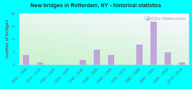
- New bridges - historical statistics
- 41900-1909
- 11910-1919
- 21940-1949
- 61950-1959
- 41960-1969
- 81980-1989
- 171990-1999
- 52000-2009
- 12010-2019
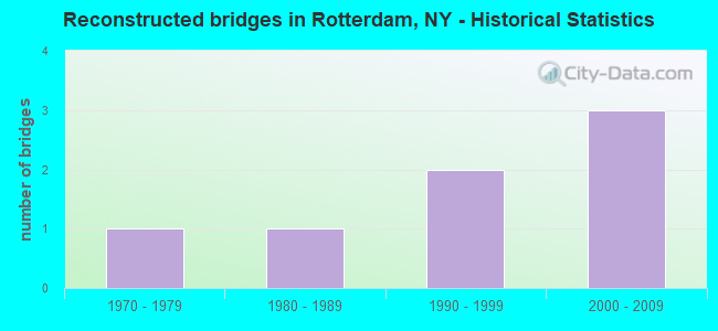
- Reconstructed bridges - Historical Statistics
- 11970-1979
- 11980-1989
- 21990-1999
- 32000-2009
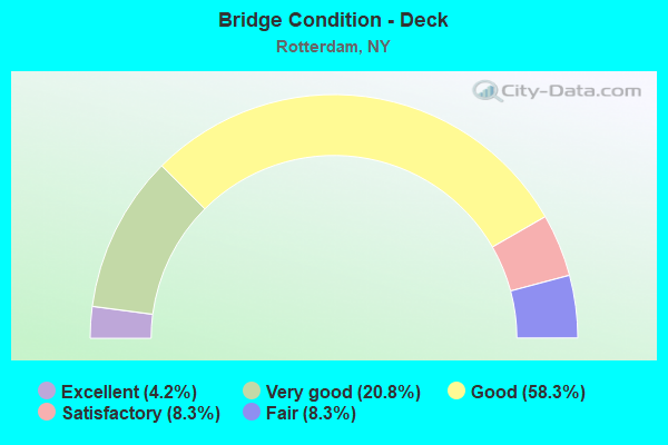
- Bridge Condition - Deck
- 4.2%Excellent
- 20.8%Very good
- 58.3%Good
- 8.3%Satisfactory
- 8.3%Fair
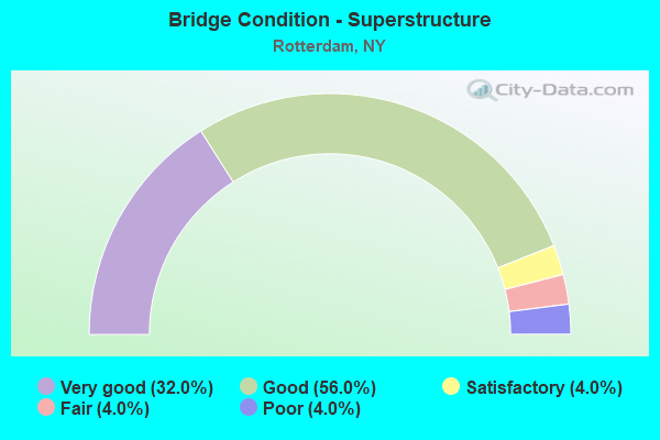
- Bridge Condition - Superstructure
- 32.0%Very good
- 56.0%Good
- 4.0%Satisfactory
- 4.0%Fair
- 4.0%Poor
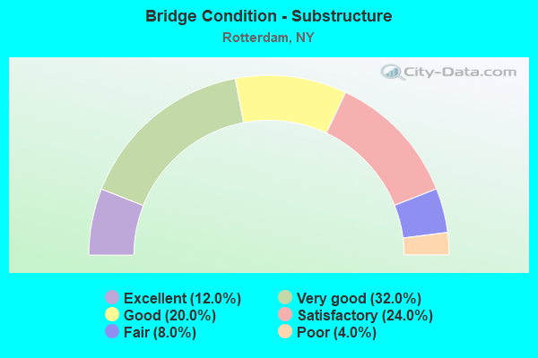
- Bridge Condition - Substructure
- 12.0%Excellent
- 32.0%Very good
- 20.0%Good
- 24.0%Satisfactory
- 8.0%Fair
- 4.0%Poor
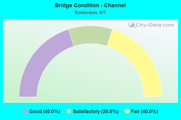
- Bridge Condition - Channel
- 40.0%Good
- 20.0%Satisfactory
- 40.0%Fair
Find on map >> Show street view
Structure Number: 100417, Location: JCT RTE 7 + I90 (Lat: 42.786706, Lng: -74.013658), Route carried "on" structure: State highway 7, Year Built: 1982, Status: Open, Structure Length: 6.49m (21.29ft), Average Daily Traffic: 9,687 (year 2020), Truck Traffic: 17%, Average Future Daily Traffic: 9,732 (year 2040), Design Load: HS 20+Mod, Features Intersected: 90IX EB, RTE I90
Minimum Vertical Clearance: 30+ m (98+ ft), Kilometerpoint: 23.202, Lanes on structure: 2, Lanes under structure: 8, Base Highway Network: Yes, Owner: State Toll Authority, Approaching Roadway Width: 19.5m (64.0ft), Skew: 20 degrees, Material/Design: Steel continuous, Design/Construction: Stringer/Multi-beam, Number Of Spans In Main Unit: 2, Length of Maximum Span: 32.6m (107.0ft), Curb-To-Curb Width: 20.4m (66.9ft), Out-to-Out Width: 21.3m (69.9ft)
Condition: Deck: Good, Superstructure: Good, Substructure: Satisfactory, Operating Rating: 73.5 metric tons, Method Used To Determine Operating Rating: Load Factor (LF), Inventory Rating: 44.5 metric tons, Method Used To Determine Inventory Rating: Load Factor (LF), Structural Evaluation: Equal to present minimum criteria, Deck Geometry: Superior to present desirable criteria, Underclear: High priority of corrective action, Approach Roadway Alignment: Equal to present desirable criteria, Length Of Structure Improvement: 6.49m (21.29ft), Designated Inspection Frequency: Every 24 months, Inspection Date: June 2020, Bridge Improvement Cost: $3,241,000, Roadway Improvement Cost: $1,898,000, Total Project Cost: $5,138,000 ( Estimate for 2021), Deck Structure Type: Concrete Cast-file-Place, Wearing Surface/Protective System: Wearing Surface: Integral Concrete
Find on map >> Show street view
Structure Number: 100418, Location: .7 MI SW JCT SH7 & SH159 (Lat: 42.787392, Lng: -73.993686), Route carried "on" structure: State highway 7, Year Built: 1940, Year Reconstructed: 1990, Status: Open, Structure Length: 6.64m (21.78ft), Average Daily Traffic: 7,366 (year 2018), Truck Traffic: 18%, Average Future Daily Traffic: 7,400 (year 2040), Design Load: HS 20, Features Intersected: CSX TRANSPORTATION
Minimum Vertical Clearance: 30+ m (98+ ft), Kilometerpoint: 24.811, Lanes on structure: 2, Base Highway Network: Yes, Owner: State Highway Agency, Approaching Roadway Width: 14.6m (47.9ft), Material/Design: Steel, Design/Construction: Girder and Floorbeam System, Number Of Spans In Main Unit: 1, Number Of Approach Spans: 2, Length of Maximum Span: 35.4m (116.1ft), Curb-To-Curb Width: 14.8m (48.6ft), Out-to-Out Width: 15.8m (51.8ft)
Condition: Deck: Good, Superstructure: Satisfactory, Substructure: Poor, Operating Rating: 89.8 metric tons, Method Used To Determine Operating Rating: Load Factor (LF), Inventory Rating: 53.5 metric tons, Method Used To Determine Inventory Rating: Load Factor (LF), Structural Evaluation: Meets minimum limits, Deck Geometry: Superior to present desirable criteria, Underclear: Meets minimum limits, Approach Roadway Alignment: Equal to present minimum criteria, Length Of Structure Improvement: 6.64m (21.78ft), Designated Inspection Frequency: Every 24 months, Critical Feature Inspection Frequency: Every 12 months, Inspection Date: November 2021, Critical Feature Inspection Date: November 2021, Bridge Improvement Cost: $3,061,000, Roadway Improvement Cost: $1,793,000, Total Project Cost: $4,854,000 ( Estimate for 2021), Deck Structure Type: Concrete Cast-file-Place, Wearing Surface/Protective System: Wearing Surface: Integral Concrete, Deck Protection: Epoxy Coated Reinforcing
Find on map >> Show street view
Structure Number: 10042, Location: JCT RTE 7 < RTE I890 (Lat: 42.760025, Lng: -73.932419), Route carried "on" structure: County highway 7, Year Built: 1960, Year Reconstructed: 2006, Status: Open, Structure Length: 6.37m (20.90ft), Average Daily Traffic: 5,856 (year 2019), Truck Traffic: 8%, Average Future Daily Traffic: 5,883 (year 2040), Design Load: HS 25 or greater, Features Intersected: 890I890I11021001 WB, RTE
Minimum Vertical Clearance: 30+ m (98+ ft), Kilometerpoint: 0.097, Lanes on structure: 4, Lanes under structure: 6, Owner: State Highway Agency, Approaching Roadway Width: 19.5m (64.0ft), Skew: 1 degrees, Material/Design: Steel, Design/Construction: Stringer/Multi-beam, Number Of Spans In Main Unit: 4, Length of Maximum Span: 20.1m (65.9ft), Curb-To-Curb Width: 16.8m (55.1ft), Out-to-Out Width: 18.2m (59.7ft)
Condition: Deck: Very good, Superstructure: Good, Substructure: Satisfactory, Operating Rating: 62.6 metric tons, Method Used To Determine Operating Rating: Load Factor (LF), Inventory Rating: 37.2 metric tons, Method Used To Determine Inventory Rating: Load Factor (LF), Structural Evaluation: Equal to present minimum criteria, Deck Geometry: Somewhat better than minimum adequacy, Underclear: High priority of corrective action, Approach Roadway Alignment: Equal to present desirable criteria, Length Of Structure Improvement: 6.37m (20.90ft), Designated Inspection Frequency: Every 24 months, Inspection Date: August 2020, Bridge Improvement Cost: $2,424,000, Roadway Improvement Cost: $1,420,000, Total Project Cost: $3,844,000 ( Estimate for 2021), Deck Structure Type: Concrete Cast-file-Place, Wearing Surface/Protective System: Wearing Surface: Bituminous, Deck Protection: Epoxy Coated Reinforcing
Find on map >> Show street view
Structure Number: 100422, Location: 0.8 MI SW JCT 7 & I-890 (Lat: 42.771036, Lng: -73.926747), Route carried "on" structure: County highway , Year Built: 1998, Status: Open, Structure Length: 6.52m (21.39ft), Average Daily Traffic: 7,460 (year 2018), Truck Traffic: 4%, Average Future Daily Traffic: 9,230 (year 2040), Design Load: HS 25 or greater, Features Intersected: 890I 7 16071007, RTE I89, Facility Carried by Structure: HIGH BRIDGE ROAD
Minimum Vertical Clearance: 30+ m (98+ ft), Kilometerpoint: 0.338, Lanes on structure: 2, Lanes under structure: 4, Owner: State Highway Agency, Approaching Roadway Width: 14.3m (46.9ft), Skew: 2 degrees, Material/Design: Steel continuous, Design/Construction: Stringer/Multi-beam, Number Of Spans In Main Unit: 2, Length of Maximum Span: 32.0m (105.0ft), Curb or Sidewalk Widths: Left: 1.5m (4.9ft), Right: 0.0m, Curb-To-Curb Width: 14.4m (47.2ft), Out-to-Out Width: 16.7m (54.8ft)
Condition: Deck: Good, Superstructure: Good, Substructure: Satisfactory, Operating Rating: 83.5 metric tons, Method Used To Determine Operating Rating: Load Factor (LF), Inventory Rating: 45.4 metric tons, Method Used To Determine Inventory Rating: Load Factor (LF), Structural Evaluation: Equal to present minimum criteria, Deck Geometry: Superior to present desirable criteria, Underclear: Meets minimum limits, Approach Roadway Alignment: Better than present minimum criteria, Length Of Structure Improvement: 6.52m (21.39ft), Designated Inspection Frequency: Every 24 months, Inspection Date: August 2020, Bridge Improvement Cost: $2,307,000, Roadway Improvement Cost: $1,351,000, Total Project Cost: $3,658,000 ( Estimate for 2021), Deck Structure Type: Concrete Cast-file-Place, Wearing Surface/Protective System: Wearing Surface: Integral Concrete, Deck Protection: Epoxy Coated Reinforcing
Find on map >> Show street view
Structure Number: 1004239, Location: 1/4 MI SW JCT SH7 & I890 (Lat: 42.778739, Lng: -73.924461), Route carried "on" structure: Interstate 890, Year Built: 1991, Status: Open, Structure Length: 7.13m (23.39ft), Average Daily Traffic: 30,566 (year 2018), Truck Traffic: 4%, Average Future Daily Traffic: 48,437 (year 2040), Design Load: HS 20+Mod, Features Intersected: CSX TRANS/ AMTRAK
Minimum Vertical Clearance: 30+ m (98+ ft), Kilometerpoint: 1.995, Lanes on structure: 6, Base Highway Network: Yes, Owner: State Highway Agency, Approaching Roadway Width: 25.6m (84.0ft), Skew: 23 degrees, Material/Design: Steel continuous, Design/Construction: Stringer/Multi-beam, Number Of Spans In Main Unit: 4, Length of Maximum Span: 18.5m (60.7ft), Curb-To-Curb Width: 25.5m (83.7ft), Out-to-Out Width: 27.2m (89.2ft)
Condition: Deck: Good, Superstructure: Very good, Substructure: Good, Operating Rating: 87.1 metric tons, Method Used To Determine Operating Rating: Load Factor (LF), Inventory Rating: 55.3 metric tons, Method Used To Determine Inventory Rating: Load Factor (LF), Structural Evaluation: Better than present minimum criteria, Deck Geometry: Meets minimum limits, Underclear: Meets minimum limits, Approach Roadway Alignment: Equal to present desirable criteria, Length Of Structure Improvement: 7.13m (23.39ft), Designated Inspection Frequency: Every 24 months, Inspection Date: September 2021, Bridge Improvement Cost: $4,144,000, Roadway Improvement Cost: $2,427,000, Total Project Cost: $6,571,000 ( Estimate for 2021), Deck Structure Type: Concrete Cast-file-Place, Wearing Surface/Protective System: Wearing Surface: Integral Concrete, Deck Protection: Epoxy Coated Reinforcing
Find on map >> Show street view
Structure Number: 1004249, Location: JCT RTES 7 & I890 (Lat: 42.782156, Lng: -73.923194), Route carried "on" structure: State highway 7, Year Built: 1962, Year Reconstructed: 2013, Status: Open, Structure Length: 6.61m (21.69ft), Average Daily Traffic: 11,592 (year 2018), Truck Traffic: 3%, Average Future Daily Traffic: 11,646 (year 2040), Design Load: HS 20, Features Intersected: 890I890I16013006, RTE I8
Minimum Vertical Clearance: 30+ m (98+ ft), Kilometerpoint: 0.547, Lanes on structure: 4, Lanes under structure: 7, Base Highway Network: Yes, Owner: State Highway Agency, Approaching Roadway Width: 21.9m (71.9ft), Skew: 22 degrees, Material/Design: Steel, Design/Construction: Stringer/Multi-beam, Number Of Spans In Main Unit: 4, Length of Maximum Span: 21.6m (70.9ft), Curb-To-Curb Width: 17.4m (57.1ft), Out-to-Out Width: 18.7m (61.4ft)
Condition: Deck: Very good, Superstructure: Fair, Substructure: Fair, Operating Rating: 37.3 metric tons, Method Used To Determine Operating Rating: Load and Resistance Factor Rating (LRFR) rating reported by rating factor(RF) method using HL-93 loadings, Inventory Rating: 28.5 metric tons, Method Used To Determine Inventory Rating: Load and Resistance Factor Rating (LRFR) rating reported by rating factor(RF) method using HL-93 loadings, Structural Evaluation: Somewhat better than minimum adequacy, Deck Geometry: Somewhat better than minimum adequacy, Underclear: High priority of corrective action, Approach Roadway Alignment: Equal to present desirable criteria, Length Of Structure Improvement: 6.61m (21.69ft), Designated Inspection Frequency: Every 24 months, Inspection Date: June 2020, Bridge Improvement Cost: $2,683,000, Roadway Improvement Cost: $1,571,000, Total Project Cost: $4,254,000 ( Estimate for 2021), Deck Structure Type: Concrete Cast-file-Place, Wearing Surface/Protective System: Wearing Surface: Integral Concrete, Deck Protection: Epoxy Coated Reinforcing
Find on map >> Show street view
Structure Number: 103833, Location: 1 MILE S JCT SH146 & I890 (Lat: 42.784289, Lng: -73.930536), Route carried "on" structure: State highway 146, Year Built: 1993, Status: Open, Structure Length: 6.19m (20.31ft), Average Daily Traffic: 6,967 (year 2020), Truck Traffic: 4%, Average Future Daily Traffic: 6,999 (year 2040), Design Load: HS 20, Features Intersected: CHRISLER AVENUE, CSX TRA
Minimum Vertical Clearance: 30+ m (98+ ft), Kilometerpoint: 2.880, Lanes on structure: 2, Lanes under structure: 2, Base Highway Network: Yes, Owner: State Highway Agency, Approaching Roadway Width: 9.1m (29.9ft), Skew: 2 degrees, Material/Design: Prestressed concrete, Design/Construction: Box Beam or Girders - Multiple, Number Of Spans In Main Unit: 3, Length of Maximum Span: 19.5m (64.0ft), Curb or Sidewalk Widths: Left: 1.5m (4.9ft), Right: 1.5m (4.9ft), Curb-To-Curb Width: 9.1m (29.9ft), Out-to-Out Width: 12.7m (41.7ft)
Condition: Deck: Fair, Superstructure: Poor, Substructure: Very good, Operating Rating: 89.8 metric tons, Method Used To Determine Operating Rating: Load Factor (LF), Inventory Rating: 44.5 metric tons, Method Used To Determine Inventory Rating: Load Factor (LF), Structural Evaluation: Meets minimum limits, Deck Geometry: Meets minimum limits, Underclear: High priority of corrective action, Approach Roadway Alignment: Equal to present desirable criteria, Length Of Structure Improvement: 6.18m (20.28ft), Designated Inspection Frequency: Every 24 months, Inspection Date: December 2021, Bridge Improvement Cost: $3,066,000, Roadway Improvement Cost: $1,795,000, Total Project Cost: $4,861,000 ( Estimate for 2021), Deck Structure Type: Concrete Cast-file-Place, Wearing Surface/Protective System: Wearing Surface: Bituminous, Deck Protection: Epoxy Coated Reinforcing
Find on map >> Show street view
Structure Number: 10387, Location: 1.7 MI S JCT SH 7 & SH158 (Lat: 42.766531, Lng: -73.982350), Route carried "on" structure: State highway 158, Year Built: 1990, Status: Open, Structure Length: 2.38m (7.81ft), Average Daily Traffic: 5,805 (year 2020), Truck Traffic: 4%, Average Future Daily Traffic: 7,182 (year 2040), Design Load: HS 20, Features Intersected: CSX TRANSPORTATION
Minimum Vertical Clearance: 30+ m (98+ ft), Kilometerpoint: 1.577, Lanes on structure: 2, Base Highway Network: Yes, Owner: State Highway Agency, Approaching Roadway Width: 9.1m (29.9ft), Material/Design: Prestressed concrete, Design/Construction: Box Beam or Girders - Multiple, Number Of Spans In Main Unit: 1, Length of Maximum Span: 23.4m (76.8ft), Curb-To-Curb Width: 9.0m (29.5ft), Out-to-Out Width: 9.9m (32.5ft)
Condition: Deck: Fair, Superstructure: Good, Substructure: Good, Operating Rating: 78.9 metric tons, Method Used To Determine Operating Rating: Load Factor (LF), Inventory Rating: 33.6 metric tons, Method Used To Determine Inventory Rating: Load Factor (LF), Structural Evaluation: Better than present minimum criteria, Deck Geometry: High priority of replacement, Underclear: Equal to present minimum criteria, Approach Roadway Alignment: Equal to present desirable criteria, Length Of Structure Improvement: 2.37m (7.78ft), Designated Inspection Frequency: Every 24 months, Inspection Date: September 2021, Bridge Improvement Cost: $665,000, Roadway Improvement Cost: $390,000, Total Project Cost: $1,055,000 ( Estimate for 2021), Deck Structure Type: Concrete Cast-file-Place, Wearing Surface/Protective System: Wearing Surface: Monolithic Concrete
Find on map >> Show street view
Structure Number: 103871, Location: 1.2 MI S JCT RTS 7 & 158 (Lat: 42.771433, Lng: -73.975297), Route carried "on" structure: State highway 158, Year Built: 1996, Status: Open, Structure Length: 6.34m (20.80ft), Average Daily Traffic: 5,805 (year 2020), Truck Traffic: 4%, Average Future Daily Traffic: 7,182 (year 2040), Design Load: HS 25 or greater, Features Intersected: 90IX EB, RTE I90
Minimum Vertical Clearance: 30+ m (98+ ft), Kilometerpoint: 2.381, Lanes on structure: 2, Lanes under structure: 6, Base Highway Network: Yes, Owner: State Toll Authority, Approaching Roadway Width: 12.2m (40.0ft), Material/Design: Steel continuous, Design/Construction: Stringer/Multi-beam, Number Of Spans In Main Unit: 2, Length of Maximum Span: 31.4m (103.0ft), Curb-To-Curb Width: 12.2m (40.0ft), Out-to-Out Width: 13.1m (43.0ft)
Condition: Deck: Satisfactory, Superstructure: Very good, Substructure: Very good, Operating Rating: 87.1 metric tons, Method Used To Determine Operating Rating: Load Factor (LF), Inventory Rating: 51.7 metric tons, Method Used To Determine Inventory Rating: Load Factor (LF), Structural Evaluation: Equal to present desirable criteria, Deck Geometry: Somewhat better than minimum adequacy, Underclear: Meets minimum limits, Approach Roadway Alignment: Equal to present desirable criteria, Length Of Structure Improvement: 6.33m (20.77ft), Designated Inspection Frequency: Every 24 months, Inspection Date: October 2021, Bridge Improvement Cost: $1,723,000, Roadway Improvement Cost: $1,009,000, Total Project Cost: $2,732,000 ( Estimate for 2021), Deck Structure Type: Concrete Cast-file-Place, Wearing Surface/Protective System: Wearing Surface: Integral Concrete, Deck Protection: Galvanized Reinforcing
Find on map >> Show street view
Structure Number: 103875, Location: 1.2 MI N JCT SH 159 & I90 (Lat: 42.810950, Lng: -74.022536), Route carried "on" structure: State highway 159, Year Built: 2012, Status: Open, Structure Length: 1.16m (3.81ft), Average Daily Traffic: 3,036 (year 2018), Truck Traffic: 6%, Average Future Daily Traffic: 3,756 (year 2040), Features Intersected: POENTIC KILL
Minimum Vertical Clearance: 30+ m (98+ ft), Kilometerpoint: 16.669, Lanes on structure: 2, Base Highway Network: Yes, Owner: State Highway Agency, Approaching Roadway Width: 9.4m (30.8ft), Skew: 4 degrees, Material/Design: Concrete, Design/Construction: Frame, Number Of Spans In Main Unit: 1, Length of Maximum Span: 11.2m (36.7ft), Curb-To-Curb Width: 9.5m (31.2ft), Out-to-Out Width: 10.5m (34.4ft)
Condition: Superstructure: Good, Substructure: Very good, Channel: Fair, Operating Rating: 76.2 metric tons, Method Used To Determine Operating Rating: Load Factor (LF), Inventory Rating: 45.4 metric tons, Method Used To Determine Inventory Rating: Load Factor (LF), Structural Evaluation: Better than present minimum criteria, Deck Geometry: Meets minimum limits, Waterway Adequacy: Meets minimum limits, Approach Roadway Alignment: Equal to present desirable criteria, Length Of Structure Improvement: 1.15m (3.77ft), Designated Inspection Frequency: Every 24 months, Inspection Date: November 2020, Bridge Improvement Cost: $342,000, Roadway Improvement Cost: $200,000, Total Project Cost: $543,000 ( Estimate for 2021)
Find on map >> Show street view
Structure Number: 103876, Location: JCT RTE 159 & I90 (Lat: 42.796375, Lng: -74.017031), Route carried "on" structure: State highway 159, Year Built: 1952, Status: Open, Structure Length: 6.89m (22.60ft), Average Daily Traffic: 2,782 (year 2020), Truck Traffic: 6%, Average Future Daily Traffic: 3,379 (year 2040), Design Load: HS 20+Mod, Features Intersected: 90IX, RTE I90
Minimum Vertical Clearance: 30+ m (98+ ft), Kilometerpoint: 18.536, Lanes on structure: 2, Lanes under structure: 5, Base Highway Network: Yes, Owner: State Toll Authority, Approaching Roadway Width: 10.1m (33.1ft), Skew: 2 degrees, Material/Design: Steel, Design/Construction: Stringer/Multi-beam, Number Of Spans In Main Unit: 4, Length of Maximum Span: 19.8m (65.0ft), Curb-To-Curb Width: 11.0m (36.1ft), Out-to-Out Width: 11.9m (39.0ft)
Condition: Deck: Good, Superstructure: Good, Substructure: Good, Operating Rating: 72.6 metric tons, Method Used To Determine Operating Rating: Load Factor (LF), Inventory Rating: 44.5 metric tons, Method Used To Determine Inventory Rating: Load Factor (LF), Structural Evaluation: Better than present minimum criteria, Deck Geometry: Somewhat better than minimum adequacy, Underclear: High priority of corrective action, Approach Roadway Alignment: Equal to present desirable criteria, Length Of Structure Improvement: 6.88m (22.57ft), Designated Inspection Frequency: Every 24 months, Inspection Date: June 2020, Bridge Improvement Cost: $1,782,000, Roadway Improvement Cost: $1,044,000, Total Project Cost: $2,826,000 ( Estimate for 2021), Deck Structure Type: Concrete Cast-file-Place, Wearing Surface/Protective System: Wearing Surface: Integral Concrete, Deck Protection: Epoxy Coated Reinforcing
Find on map >> Show street view
Structure Number: 103877, Location: .3 MI S JCT SH 159 & I90 (Lat: 42.795128, Lng: -74.011175), Route carried "on" structure: State highway 159, Year Built: 1991, Status: Open, Structure Length: 5.33m (17.49ft), Average Daily Traffic: 2,782 (year 2020), Truck Traffic: 6%, Average Future Daily Traffic: 3,379 (year 2040), Design Load: HS 20, Features Intersected: DELAWARE & HUDSON
Minimum Vertical Clearance: 30+ m (98+ ft), Kilometerpoint: 19.034, Lanes on structure: 2, Base Highway Network: Yes, Owner: State Highway Agency, Approaching Roadway Width: 9.8m (32.2ft), Skew: 3 degrees, Material/Design: Steel continuous, Design/Construction: Stringer/Multi-beam, Number Of Spans In Main Unit: 3, Length of Maximum Span: 21.3m (69.9ft), Curb-To-Curb Width: 9.6m (31.5ft), Out-to-Out Width: 10.5m (34.4ft)
Condition: Deck: Good, Superstructure: Very good, Substructure: Very good, Operating Rating: 66.2 metric tons, Method Used To Determine Operating Rating: Load Factor (LF), Inventory Rating: 39.9 metric tons, Method Used To Determine Inventory Rating: Load Factor (LF), Structural Evaluation: Equal to present desirable criteria, Deck Geometry: Meets minimum limits, Underclear: Better than present minimum criteria, Approach Roadway Alignment: Equal to present desirable criteria, Length Of Structure Improvement: 5.33m (17.49ft), Designated Inspection Frequency: Every 24 months, Inspection Date: September 2021, Bridge Improvement Cost: $1,337,000, Roadway Improvement Cost: $783,000, Total Project Cost: $2,119,000 ( Estimate for 2021), Deck Structure Type: Concrete Cast-file-Place, Wearing Surface/Protective System: Wearing Surface: Integral Concrete, Deck Protection: Epoxy Coated Reinforcing
Find on map >> Show street view
Structure Number: 103878, Location: .8 MI NW JCT SH7 & SH159 (Lat: 42.792947, Lng: -73.996900), Route carried "on" structure: State highway 159, Year Built: 2007, Status: Open, Structure Length: 4.05m (13.29ft), Average Daily Traffic: 4,250 (year 2018), Truck Traffic: 6%, Average Future Daily Traffic: 5,258 (year 2040), Design Load: HS 25 or greater, Features Intersected: CSX TRANSPORTATION
Minimum Vertical Clearance: 30+ m (98+ ft), Kilometerpoint: 20.225, Lanes on structure: 2, Base Highway Network: Yes, Owner: State Highway Agency, Approaching Roadway Width: 10.4m (34.1ft), Skew: 2 degrees, Material/Design: Concrete, Number Of Spans In Main Unit: 1, Length of Maximum Span: 40.0m (131.2ft), Curb-To-Curb Width: 10.2m (33.5ft), Out-to-Out Width: 13.7m (44.9ft)
Condition: Deck: Very good, Superstructure: Very good, Substructure: Very good, Inventory Rating: 68.9 metric tons, Method Used To Determine Inventory Rating: Load Factor (LF), Structural Evaluation: Equal to present desirable criteria, Deck Geometry: Meets minimum limits, Underclear: Somewhat better than minimum adequacy, Approach Roadway Alignment: Equal to present desirable criteria, Length Of Structure Improvement: 4.05m (13.29ft), Designated Inspection Frequency: Every 24 months, Critical Feature Inspection Frequency: Every 24 months, Inspection Date: November 2021, Critical Feature Inspection Date: November 2021, Bridge Improvement Cost: $1,115,000, Roadway Improvement Cost: $653,000, Total Project Cost: $1,767,000 ( Estimate for 2021), Deck Structure Type: Concrete Precast Panels, Wearing Surface/Protective System: Wearing Surface: Monolithic Concrete
Find on map >> Show street view
Structure Number: 103879, Location: .8 MI NW Jct NY7 & NY159 (Lat: 42.793017, Lng: -73.998064), Route carried "on" structure: State highway 159, Year Built: 2007, Status: Open, Structure Length: 2.23m (7.32ft), Average Daily Traffic: 4,250 (year 2018), Truck Traffic: 6%, Average Future Daily Traffic: 5,258 (year 2040), Design Load: HS 25 or greater, Features Intersected: KELLAR AVE
Minimum Vertical Clearance: 30+ m (98+ ft), Kilometerpoint: 20.145, Lanes on structure: 2, Lanes under structure: 2, Base Highway Network: Yes, Owner: State Highway Agency, Approaching Roadway Width: 10.2m (33.5ft), Material/Design: Prestressed concrete, Design/Construction: Box Beam or Girders - Multiple, Number Of Spans In Main Unit: 1, Length of Maximum Span: 21.3m (69.9ft), Curb-To-Curb Width: 10.2m (33.5ft), Out-to-Out Width: 11.5m (37.7ft)
Condition: Deck: Good, Superstructure: Very good, Substructure: Excellent, Inventory Rating: 61.7 metric tons, Method Used To Determine Inventory Rating: Load Factor (LF), Structural Evaluation: Equal to present desirable criteria, Deck Geometry: Meets minimum limits, Underclear: High priority of corrective action, Approach Roadway Alignment: Equal to present desirable criteria, Length Of Structure Improvement: 2.22m (7.28ft), Designated Inspection Frequency: Every 24 months, Inspection Date: July 2021, Bridge Improvement Cost: $878,000, Roadway Improvement Cost: $514,000, Total Project Cost: $1,392,000 ( Estimate for 2021), Deck Structure Type: Concrete Cast-file-Place, Wearing Surface/Protective System: Wearing Surface: Monolithic Concrete
Find on map >> Show street view
Structure Number: 104773, Location: IN PINE GROVE (Lat: 42.763908, Lng: -74.001644), Route carried "on" structure: State highway 406, Year Built: 1946, Year Reconstructed: 1986, Status: Open, Structure Length: 2.13m (6.99ft), Average Daily Traffic: 1,288 (year 2020), Truck Traffic: 7%, Average Future Daily Traffic: 1,593 (year 2040), Design Load: HS 20, Features Intersected: NORMANS KILL
Minimum Vertical Clearance: 30+ m (98+ ft), Kilometerpoint: 4.505, Lanes on structure: 2, Base Highway Network: Yes, Owner: State Highway Agency, Approaching Roadway Width: 10.4m (34.1ft), Skew: 1 degrees, Material/Design: Steel, Design/Construction: Stringer/Multi-beam, Number Of Spans In Main Unit: 1, Length of Maximum Span: 21.0m (68.9ft), Curb-To-Curb Width: 10.3m (33.8ft), Out-to-Out Width: 10.9m (35.8ft)
Condition: Deck: Satisfactory, Superstructure: Good, Substructure: Fair, Channel: Good, Inventory Rating: 64.4 metric tons, Method Used To Determine Inventory Rating: Load Factor (LF), Structural Evaluation: Somewhat better than minimum adequacy, Deck Geometry: Somewhat better than minimum adequacy, Waterway Adequacy: Somewhat better than minimum adequacy, Approach Roadway Alignment: Equal to present desirable criteria, Length Of Structure Improvement: 2.13m (6.99ft), Designated Inspection Frequency: Every 24 months, Inspection Date: June 2021, Bridge Improvement Cost: $979,000, Roadway Improvement Cost: $573,000, Total Project Cost: $1,552,000 ( Estimate for 2021), Deck Structure Type: Concrete Cast-file-Place, Wearing Surface/Protective System: Wearing Surface: Integral Concrete, Deck Protection: Epoxy Coated Reinforcing
Find on map >> Show street view
Structure Number: 107132, Location: .7 MI SW JCT I88 & I90 (Lat: 42.783769, Lng: -74.028044), Route carried "on" structure: Ramp Interstate , Year Built: 1981, Year Reconstructed: 2012, Status: Open, Structure Length: 5.91m (19.39ft), Truck Traffic: 9%, Design Load: HS 20+Mod, Features Intersected: 88I 88I16081136, RTE I88, Facility Carried by Structure: RTE 7 CONNECTOR
Minimum Vertical Clearance: 30+ m (98+ ft), Kilometerpoint: 0.257, Lanes on structure: 2, Lanes under structure: 5, Owner: State Highway Agency, Approaching Roadway Width: 13.1m (43.0ft), Material/Design: Steel continuous, Design/Construction: Stringer/Multi-beam, Number Of Spans In Main Unit: 2, Length of Maximum Span: 30.7m (100.7ft), Curb-To-Curb Width: 13.1m (43.0ft), Out-to-Out Width: 14.4m (47.2ft)
Condition: Deck: Good, Superstructure: Good, Substructure: Satisfactory, Operating Rating: 70.8 metric tons, Method Used To Determine Operating Rating: Load Factor (LF), Inventory Rating: 41.7 metric tons, Method Used To Determine Inventory Rating: Load Factor (LF), Structural Evaluation: Equal to present minimum criteria, Deck Geometry: Superior to present desirable criteria, Underclear: Meets minimum limits, Approach Roadway Alignment: Equal to present desirable criteria, Length Of Structure Improvement: 5.91m (19.39ft), Designated Inspection Frequency: Every 24 months, Inspection Date: September 2020, Bridge Improvement Cost: $2,076,000, Roadway Improvement Cost: $1,216,000, Total Project Cost: $3,291,000 ( Estimate for 2021), Deck Structure Type: Concrete Cast-file-Place, Wearing Surface/Protective System: Wearing Surface: Integral Concrete, Deck Protection: Epoxy Coated Reinforcing
Find on map >> Show street view
Structure Number: 1071819, Location: JCT OF RTS I-88 + I-90 (Lat: 42.790433, Lng: -74.016081), Route carried "on" structure: Ramp Other road 88, Year Built: 1982, Status: Open, Structure Length: 7.25m (23.79ft), Average Daily Traffic: 2,468 (year 2019), Truck Traffic: 18%, Average Future Daily Traffic: 3,911 (year 2040), Design Load: HS 20+Mod, Features Intersected: 90IX WB, RTE I90, 25A WB
Minimum Vertical Clearance: 30+ m (98+ ft), Kilometerpoint: 0.322, Lanes on structure: 3, Lanes under structure: 6, Toll: On Interstate toll segment, Owner: State Toll Authority, Approaching Roadway Width: 18.9m (62.0ft), Skew: 20 degrees, Material/Design: Steel continuous, Design/Construction: Stringer/Multi-beam, Number Of Spans In Main Unit: 2, Length of Maximum Span: 40.2m (131.9ft), Curb-To-Curb Width: 18.6m (61.0ft), Out-to-Out Width: 20.1m (65.9ft)
Condition: Deck: Good, Superstructure: Good, Substructure: Satisfactory, Operating Rating: 90.7 metric tons, Method Used To Determine Operating Rating: Load Factor (LF), Inventory Rating: 54.4 metric tons, Method Used To Determine Inventory Rating: Load Factor (LF), Structural Evaluation: Equal to present minimum criteria, Deck Geometry: Superior to present desirable criteria, Underclear: Meets minimum limits, Approach Roadway Alignment: Equal to present desirable criteria, Length Of Structure Improvement: 7.25m (23.79ft), Designated Inspection Frequency: Every 24 months, Inspection Date: May 2020, Bridge Improvement Cost: $3,258,000, Roadway Improvement Cost: $1,908,000, Total Project Cost: $5,166,000 ( Estimate for 2021), Deck Structure Type: Concrete Cast-file-Place, Wearing Surface/Protective System: Wearing Surface: Integral Concrete
Find on map >> Show street view
Structure Number: 130502, Location: 1 MI SW JCT I-890 & 337 (Lat: 42.808828, Lng: -73.991944), Route carried "on" structure: State highway 337, Year Built: 1999, Status: Open, Structure Length: 2.59m (8.50ft), Average Daily Traffic: 16,496 (year 2010), Truck Traffic: 6%, Average Future Daily Traffic: 20,039 (year 2040), Design Load: HS 25 or greater, Features Intersected: POENTIC KILL
Minimum Vertical Clearance: 30+ m (98+ ft), Kilometerpoint: 3.041, Lanes on structure: 4, Base Highway Network: Yes, Owner: State Highway Agency, Approaching Roadway Width: 18.6m (61.0ft), Skew: 4 degrees, Material/Design: Concrete, Design/Construction: Frame, Number Of Spans In Main Unit: 2, Length of Maximum Span: 12.8m (42.0ft), Curb-To-Curb Width: 20.1m (65.9ft), Out-to-Out Width: 21.1m (69.2ft)
Condition: Deck: Good, Superstructure: Good, Substructure: Very good, Channel: Fair, Operating Rating: 73.5 metric tons, Method Used To Determine Operating Rating: Load Factor (LF), Inventory Rating: 43.5 metric tons, Method Used To Determine Inventory Rating: Load Factor (LF), Structural Evaluation: Better than present minimum criteria, Deck Geometry: Better than present minimum criteria, Waterway Adequacy: Meets minimum limits, Approach Roadway Alignment: Equal to present desirable criteria, Length Of Structure Improvement: 2.59m (8.50ft), Designated Inspection Frequency: Every 24 months, Inspection Date: June 2021, Bridge Improvement Cost: $1,388,000, Roadway Improvement Cost: $813,000, Total Project Cost: $2,201,000 ( Estimate for 2021)
Find on map >> Show street view
Structure Number: 330503, Location: 1.3 MILES SW OF SCOTIA (Lat: 42.816550, Lng: -73.997358), Route carried "on" structure: County highway , Year Built: 1991, Status: Open, Structure Length: 3.41m (11.19ft), Average Daily Traffic: 329 (year 2019), Truck Traffic: 6%, Average Future Daily Traffic: 461 (year 2039), Design Load: HS 20, Features Intersected: CSX TRANSPRTATION, Facility Carried by Structure: GORDON ROAD
Minimum Vertical Clearance: 30+ m (98+ ft), Kilometerpoint: 3.540, Lanes on structure: 2, Owner: Railroad, Maintenance Responsibility: County Highway Agency, Approaching Roadway Width: 7.9m (25.9ft), Skew: 3 degrees, Material/Design: Steel, Design/Construction: Stringer/Multi-beam, Number Of Spans In Main Unit: 1, Length of Maximum Span: 32.9m (107.9ft), Curb-To-Curb Width: 7.7m (25.3ft), Out-to-Out Width: 8.7m (28.5ft)
Condition: Deck: Good, Superstructure: Good, Substructure: Good, Operating Rating: 91.6 metric tons, Method Used To Determine Operating Rating: Load Factor (LF), Inventory Rating: 54.4 metric tons, Method Used To Determine Inventory Rating: Load Factor (LF), Structural Evaluation: Better than present minimum criteria, Deck Geometry: Somewhat better than minimum adequacy, Underclear: Somewhat better than minimum adequacy, Approach Roadway Alignment: Equal to present desirable criteria, Length Of Structure Improvement: 3.41m (11.19ft), Designated Inspection Frequency: Every 24 months, Inspection Date: October 2021, Bridge Improvement Cost: $1,306,000, Roadway Improvement Cost: $765,000, Total Project Cost: $2,071,000 ( Estimate for 2021), Deck Structure Type: Concrete Cast-file-Place, Wearing Surface/Protective System: Wearing Surface: Integral Concrete, Deck Protection: Epoxy Coated Reinforcing
Find on map >> Show street view
Structure Number: 330507, Location: 1 MILE N OF SCHENECTADY (Lat: 42.801389, Lng: -74.000811), Route carried "on" structure: County highway , Year Built: 1983, Status: Open, Structure Length: 5.70m (18.70ft), Average Daily Traffic: 932 (year 2019), Truck Traffic: 6%, Average Future Daily Traffic: 1,305 (year 2039), Design Load: H 20, Features Intersected: NORFOLK SOUTHERN RR, POE, Facility Carried by Structure: PRINCETOWN ROAD
Minimum Vertical Clearance: 30+ m (98+ ft), Kilometerpoint: 2.076, Lanes on structure: 2, Owner: County Highway Agency, Approaching Roadway Width: 9.4m (30.8ft), Material/Design: Steel continuous, Design/Construction: Stringer/Multi-beam, Number Of Spans In Main Unit: 2, Length of Maximum Span: 33.8m (110.9ft), Curb-To-Curb Width: 9.4m (30.8ft), Out-to-Out Width: 10.4m (34.1ft)
Condition: Deck: Very good, Superstructure: Good, Substructure: Good, Channel: Satisfactory, Operating Rating: 36.3 metric tons, Method Used To Determine Operating Rating: Load and Resistance Factor Rating (LRFR) rating reported by rating factor(RF) method using HL-93 loadings, Inventory Rating: 28.2 metric tons, Method Used To Determine Inventory Rating: Load and Resistance Factor Rating (LRFR) rating reported by rating factor(RF) method using HL-93 loadings, Structural Evaluation: Better than present minimum criteria, Deck Geometry: Equal to present minimum criteria, Underclear: Equal to present minimum criteria, Waterway Adequacy: Meets minimum limits, Approach Roadway Alignment: Equal to present desirable criteria, Length Of Structure Improvement: 5.69m (18.67ft), Designated Inspection Frequency: Every 24 months, Inspection Date: December 2021, Bridge Improvement Cost: $1,393,000, Roadway Improvement Cost: $815,000, Total Project Cost: $2,208,000 ( Estimate for 2021), Deck Structure Type: Concrete Cast-file-Place, Wearing Surface/Protective System: Wearing Surface: Integral Concrete, Deck Protection: Epoxy Coated Reinforcing
Find on map >> Show street view
Structure Number: 551366, Location: 1.7 MI NW OF INT25 ON I90 (Lat: 42.767344, Lng: -73.962058), Route carried "on" structure: County highway , Year Built: 1999, Status: Open, Structure Length: 5.61m (18.41ft), Average Daily Traffic: 2,458 (year 2019), Truck Traffic: 3%, Average Future Daily Traffic: 3,041 (year 2040), Design Load: HS 25 or greater, Features Intersected: 90IX EB, RTE I90, Facility Carried by Structure: HELDERBERG AVENUE
Minimum Vertical Clearance: 30+ m (98+ ft), Kilometerpoint: 1.142, Lanes on structure: 2, Lanes under structure: 6, Owner: State Toll Authority, Approaching Roadway Width: 10.1m (33.1ft), Material/Design: Steel continuous, Design/Construction: Stringer/Multi-beam, Number Of Spans In Main Unit: 2, Length of Maximum Span: 27.7m (90.9ft), Curb-To-Curb Width: 9.8m (32.2ft), Out-to-Out Width: 11.0m (36.1ft)
Condition: Deck: Good, Superstructure: Very good, Substructure: Excellent, Operating Rating: 89.8 metric tons, Method Used To Determine Operating Rating: Load Factor (LF), Inventory Rating: 53.5 metric tons, Method Used To Determine Inventory Rating: Load Factor (LF), Structural Evaluation: Equal to present desirable criteria, Deck Geometry: Meets minimum limits, Underclear: Meets minimum limits, Approach Roadway Alignment: Equal to present desirable criteria, Length Of Structure Improvement: 5.60m (18.37ft), Designated Inspection Frequency: Every 24 months, Inspection Date: September 2021, Bridge Improvement Cost: $1,386,000, Roadway Improvement Cost: $812,000, Total Project Cost: $2,198,000 ( Estimate for 2021), Deck Structure Type: Concrete Cast-file-Place, Wearing Surface/Protective System: Wearing Surface: Integral Concrete, Deck Protection: Galvanized Reinforcing
Find on map >> Show street view
Structure Number: 5513679, Location: 3.15 MI NW INT25 ON I90 (Lat: 42.774544, Lng: -73.986767), Route carried "on" structure: Interstate 90, Year Built: 1954, Year Reconstructed: 1982, Status: Open, Structure Length: 5.97m (19.59ft), Average Daily Traffic: 34,170 (year 2020), Truck Traffic: 27%, Average Future Daily Traffic: 54,149 (year 2040), Design Load: HS 20+Mod, Features Intersected: CSX Transportatio
Minimum Vertical Clearance: 30+ m (98+ ft), Kilometerpoint: 17.570, Lanes on structure: 6, Base Highway Network: Yes, Toll: On Interstate toll segment, Owner: State Toll Authority, Approaching Roadway Width: 34.1m (111.9ft), Skew: 33 degrees, Material/Design: Steel, Design/Construction: Stringer/Multi-beam, Number Of Spans In Main Unit: 3, Length of Maximum Span: 19.2m (63.0ft), Curb-To-Curb Width: 32.9m (107.9ft), Out-to-Out Width: 34.5m (113.2ft)
Condition: Deck: Good, Superstructure: Good, Substructure: Satisfactory, Operating Rating: 88.9 metric tons, Method Used To Determine Operating Rating: Load Factor (LF), Inventory Rating: 53.5 metric tons, Method Used To Determine Inventory Rating: Load Factor (LF), Structural Evaluation: Equal to present minimum criteria, Deck Geometry: Superior to present desirable criteria, Underclear: Somewhat better than minimum adequacy, Approach Roadway Alignment: Equal to present desirable criteria, Length Of Structure Improvement: 5.97m (19.59ft), Designated Inspection Frequency: Every 24 months, Inspection Date: June 2020, Bridge Improvement Cost: $4,633,000, Roadway Improvement Cost: $2,713,000, Total Project Cost: $7,346,000 ( Estimate for 2021), Deck Structure Type: Concrete Cast-file-Place, Wearing Surface/Protective System: Wearing Surface: Monolithic Concrete, Deck Protection: Epoxy Coated Reinforcing
Find on map >> Show street view
Structure Number: 551368, Location: DUNNSVILLE RD. CO. RD. 9R (Lat: 42.779878, Lng: -74.003314), Route carried "on" structure: Other road , Year Built: 1993, Status: Open, Structure Length: 6.43m (21.10ft), Average Daily Traffic: 2,988 (year 2020), Truck Traffic: 7%, Average Future Daily Traffic: 4,183 (year 2040), Design Load: HS 25 or greater, Features Intersected: 90IX EB, RTE I90, Facility Carried by Structure: DUNNSVILLE ROAD
Minimum Vertical Clearance: 30+ m (98+ ft), Kilometerpoint: 1.883, Lanes on structure: 2, Lanes under structure: 6, Owner: State Toll Authority, Approaching Roadway Width: 7.9m (25.9ft), Skew: 2 degrees, Material/Design: Steel continuous, Design/Construction: Stringer/Multi-beam, Number Of Spans In Main Unit: 2, Length of Maximum Span: 31.7m (104.0ft), Curb-To-Curb Width: 9.4m (30.8ft), Out-to-Out Width: 10.1m (33.1ft)
Condition: Deck: Good, Superstructure: Very good, Substructure: Very good, Operating Rating: 81.6 metric tons, Method Used To Determine Operating Rating: Load Factor (LF), Inventory Rating: 40.8 metric tons, Method Used To Determine Inventory Rating: Load Factor (LF), Structural Evaluation: Equal to present desirable criteria, Deck Geometry: Meets minimum limits, Underclear: Meets minimum limits, Approach Roadway Alignment: Equal to present minimum criteria, Length Of Structure Improvement: 6.43m (21.10ft), Designated Inspection Frequency: Every 24 months, Inspection Date: October 2021, Bridge Improvement Cost: $1,417,000, Roadway Improvement Cost: $830,000, Total Project Cost: $2,247,000 ( Estimate for 2021), Deck Structure Type: Concrete Cast-file-Place, Wearing Surface/Protective System: Wearing Surface: Integral Concrete, Deck Protection: Epoxy Coated Reinforcing
Find on map >> Show street view
Structure Number: 55137, Location: 2.86 MI SE INT26 ON I90 (Lat: 42.798122, Lng: -74.017233), Route carried "on" structure: Interstate 90, Year Built: 1955, Year Reconstructed: 2003, Status: Open, Structure Length: 0.85m (2.79ft), Average Daily Traffic: 23,069 (year 2020), Truck Traffic: 31%, Average Future Daily Traffic: 36,557 (year 2040), Design Load: HS 20+Mod, Features Intersected: POENTIC KILL
Minimum Vertical Clearance: 30+ m (98+ ft), Kilometerpoint: 13.628, Lanes on structure: 5, Base Highway Network: Yes, Toll: On Interstate toll segment, Owner: State Toll Authority, Approaching Roadway Width: 34.7m (113.8ft), Skew: 30 degrees, Material/Design: Concrete, Design/Construction: Culvert, Number Of Spans In Main Unit: 2, Length of Maximum Span: 3.7m (12.1ft)
Condition: Channel: Good, Culverts: Good, Operating Rating: 75.1 metric tons, Method Used To Determine Operating Rating: Field evaluation and documented engineering judgment, Inventory Rating: 32.7 metric tons, Method Used To Determine Inventory Rating: Field evaluation and documented engineering judgment, Structural Evaluation: Better than present minimum criteria, Waterway Adequacy: Meets minimum limits, Approach Roadway Alignment: Equal to present desirable criteria, Length Of Structure Improvement: 0.85m (2.79ft), Designated Inspection Frequency: Every 24 months, Inspection Date: August 2020, Bridge Improvement Cost: $1,195,000, Roadway Improvement Cost: $700,000, Total Project Cost: $1,894,000 ( Estimate for 2021), Wearing Surface/Protective System: Wearing Surface: Bituminous
Find on map >> Show street view
Structure Number: 551371, Location: INT PUTNAM RD-CR 54 & I90 (Lat: 42.806075, Lng: -74.018728), Route carried "on" structure: County highway , Year Built: 2001, Status: Open, Structure Length: 6.00m (19.69ft), Average Daily Traffic: 2,218 (year 2018), Truck Traffic: 5%, Average Future Daily Traffic: 2,744 (year 2040), Design Load: HS 25 or greater, Features Intersected: 90IX EB, RTE I90, Facility Carried by Structure: PUTNAM ROAD
Minimum Vertical Clearance: 30+ m (98+ ft), Kilometerpoint: 4.859, Lanes on structure: 2, Lanes under structure: 6, Owner: State Toll Authority, Approaching Roadway Width: 9.4m (30.8ft), Skew: 1 degrees, Material/Design: Steel continuous, Design/Construction: Stringer/Multi-beam, Number Of Spans In Main Unit: 2, Length of Maximum Span: 33.2m (108.9ft), Curb-To-Curb Width: 9.6m (31.5ft), Out-to-Out Width: 10.4m (34.1ft)
Condition: Deck: Excellent, Superstructure: Very good, Substructure: Excellent, Operating Rating: 79.8 metric tons, Method Used To Determine Operating Rating: Load Factor (LF), Inventory Rating: 41.7 metric tons, Method Used To Determine Inventory Rating: Load Factor (LF), Structural Evaluation: Equal to present desirable criteria, Deck Geometry: Meets minimum limits, Underclear: High priority of corrective action, Approach Roadway Alignment: Equal to present desirable criteria, Length Of Structure Improvement: 6.00m (19.69ft), Designated Inspection Frequency: Every 24 months, Inspection Date: October 2021, Bridge Improvement Cost: $1,556,000, Roadway Improvement Cost: $911,000, Total Project Cost: $2,467,000 ( Estimate for 2021), Deck Structure Type: Concrete Cast-file-Place, Wearing Surface/Protective System: Wearing Surface: Integral Concrete, Deck Protection: Other Coated Reinforcing
Find on map >> Show street view
Structure Number: 551372, Location: 1.18MI SE INT 26 ON I90 (Lat: 42.822028, Lng: -74.015889), Route carried "on" structure: County highway , Year Built: 1993, Status: Open, Structure Length: 7.38m (24.21ft), Average Daily Traffic: 329 (year 2019), Truck Traffic: 6%, Average Future Daily Traffic: 461 (year 2039), Design Load: HS 20+Mod, Features Intersected: 90IX EB, RTE I90, Facility Carried by Structure: GORDON ROAD
Minimum Vertical Clearance: 30+ m (98+ ft), Kilometerpoint: 1.545, Lanes on structure: 2, Lanes under structure: 4, Owner: State Toll Authority, Approaching Roadway Width: 9.4m (30.8ft), Skew: 3 degrees, Material/Design: Steel, Design/Construction: Stringer/Multi-beam, Number Of Spans In Main Unit: 4, Length of Maximum Span: 20.7m (67.9ft), Curb-To-Curb Width: 7.6m (24.9ft), Out-to-Out Width: 8.5m (27.9ft)
Condition: Deck: Very good, Superstructure: Good, Substructure: Very good, Operating Rating: 85.3 metric tons, Method Used To Determine Operating Rating: Load Factor (LF), Inventory Rating: 50.8 metric tons, Method Used To Determine Inventory Rating: Load Factor (LF), Structural Evaluation: Better than present minimum criteria, Deck Geometry: Somewhat better than minimum adequacy, Underclear: High priority of corrective action, Approach Roadway Alignment: Equal to present desirable criteria, Length Of Structure Improvement: 7.37m (24.18ft), Designated Inspection Frequency: Every 24 months, Inspection Date: October 2020, Bridge Improvement Cost: $1,342,000, Roadway Improvement Cost: $786,000, Total Project Cost: $2,128,000 ( Estimate for 2021), Deck Structure Type: Other, Wearing Surface/Protective System: Wearing Surface: Bituminous, Membrane: Other
Find on map >> Show street view
Structure Number: 100417, Location: JCT RTE 7 + I90 (Lat: 42.786706, Lng: -74.013658), Route carried "under" structure: Interstate 90, Year Built: 1982, Structure Length: 0. m, Average Daily Traffic: 42,438 (year 2014), Features Intersected: 90IX EB, RTE I90, Facility Carried by Structure: RTE 7
Minimum Vertical Clearance: 5.44m (17.85ft), Kilometerpoint: 255.091, Lanes on structure: 2, Lanes under structure: 4, Toll: On Interstate toll segment, Material/Design: Steel continuous, Design/Construction: Stringer/Multi-beam, Length of Maximum Span: 32.6m (107.0ft)
Find on map >> Show street view
Structure Number: 10042, Location: JCT RTE 7 < RTE I890 (Lat: 42.760025, Lng: -73.932419), Route carried "under" structure: Interstate 890, Year Built: 1960, Structure Length: 0. m, Average Daily Traffic: 33,452 (year 2002), Features Intersected: 890I890I11021001 WB, RTE, Facility Carried by Structure: RTE 7
Minimum Vertical Clearance: 4.47m (14.67ft), Kilometerpoint: 0.161, Lanes on structure: 4, Lanes under structure: 3, Material/Design: Steel, Design/Construction: Stringer/Multi-beam, Length of Maximum Span: 20.1m (65.9ft)
Find on map >> Show street view
Structure Number: 100422, Location: 0.8 MI SW JCT 7 & I-890 (Lat: 42.771036, Lng: -73.926747), Route carried "under" structure: Interstate 890, Year Built: 1998, Structure Length: 0. m, Average Daily Traffic: 21,700 (year 1979), Features Intersected: 890I 7 16071007, RTE I89, Facility Carried by Structure: HIGH BRIDGE ROAD
Minimum Vertical Clearance: 5.28m (17.32ft), Kilometerpoint: 1.142, Lanes on structure: 2, Lanes under structure: 2, Material/Design: Steel continuous, Design/Construction: Stringer/Multi-beam, Length of Maximum Span: 32.0m (105.0ft)
Find on map >> Show street view
Structure Number: 1004249, Location: JCT RTES 7 & I890 (Lat: 42.782156, Lng: -73.923194), Route carried "under" structure: Interstate 890, Year Built: 1962, Structure Length: 0. m, Average Daily Traffic: 13,500 (year 1972), Features Intersected: 890I890I16013006, RTE I8, Facility Carried by Structure: RTE 7
Minimum Vertical Clearance: 5.36m (17.59ft), Kilometerpoint: 2.381, Lanes on structure: 4, Lanes under structure: 4, Material/Design: Steel, Design/Construction: Stringer/Multi-beam, Length of Maximum Span: 21.6m (70.9ft)
Find on map >> Show street view
Structure Number: 103833, Location: 1 MILE S JCT SH146 & I890 (Lat: 42.784289, Lng: -73.930536), Route carried "under" structure: City street , Year Built: 1993, Structure Length: 0. m, Average Daily Traffic: 10,871 (year 2016), Truck Traffic: 6%, Features Intersected: CHRISLER AVENUE, CSX TRA, Facility Carried by Structure: RTE 146
Minimum Vertical Clearance: 7.34m (24.08ft), Kilometerpoint: 0.000, Lanes on structure: 2, Lanes under structure: 2, Material/Design: Prestressed concrete, Design/Construction: Box Beam or Girders - Multiple, Length of Maximum Span: 19.5m (64.0ft)
Find on map >> Show street view
Structure Number: 103871, Location: 1.2 MI S JCT RTS 7 & 158 (Lat: 42.771433, Lng: -73.975297), Route carried "under" structure: Interstate 90, Year Built: 1996, Structure Length: 0. m, Average Daily Traffic: 35,783 (year 1995), Features Intersected: 90IX EB, RTE I90, Facility Carried by Structure: RTE 158
Minimum Vertical Clearance: 5.00m (16.40ft), Kilometerpoint: 251.438, Lanes on structure: 2, Lanes under structure: 3, Toll: On Interstate toll segment, Material/Design: Steel continuous, Design/Construction: Stringer/Multi-beam, Length of Maximum Span: 31.4m (103.0ft)
Find on map >> Show street view
Structure Number: 103876, Location: JCT RTE 159 & I90 (Lat: 42.796375, Lng: -74.017031), Route carried "under" structure: Interstate 90, Year Built: 1952, Structure Length: 0. m, Average Daily Traffic: 28,207 (year 2014), Features Intersected: 90IX, RTE I90, Facility Carried by Structure: RTE 159
Minimum Vertical Clearance: 4.67m (15.32ft), Kilometerpoint: 256.201, Lanes on structure: 2, Lanes under structure: 2, Toll: On Interstate toll segment, Material/Design: Steel, Design/Construction: Stringer/Multi-beam, Length of Maximum Span: 19.8m (65.0ft)
Find on map >> Show street view
Structure Number: 103879, Location: .8 MI NW Jct NY7 & NY159 (Lat: 42.793017, Lng: -73.998064), Route carried "under" structure: Other road , Year Built: 2007, Structure Length: 0. m, Average Daily Traffic: 1,800 (year 2021), Features Intersected: KELLAR AVE, Facility Carried by Structure: RTE 159
Minimum Vertical Clearance: 5.31m (17.42ft), Kilometerpoint: 0.000, Lanes on structure: 2, Lanes under structure: 2, Material/Design: Prestressed concrete, Design/Construction: Box Beam or Girders - Multiple, Length of Maximum Span: 21.3m (69.9ft)
Find on map >> Show street view
Structure Number: 107132, Location: .7 MI SW JCT I88 & I90 (Lat: 42.783769, Lng: -74.028044), Route carried "under" structure: Interstate 88, Year Built: 1981, Structure Length: 0. m, Average Daily Traffic: 100 (year 2021), Features Intersected: 88I 88I16081136, RTE I88, Facility Carried by Structure: RTE 7 CONNECTOR
Minimum Vertical Clearance: 5.51m (18.08ft), Kilometerpoint: 58.165, Lanes on structure: 2, Lanes under structure: 2, Material/Design: Steel continuous, Design/Construction: Stringer/Multi-beam, Length of Maximum Span: 30.7m (100.7ft)
Find on map >> Show street view
Structure Number: 1071819, Location: JCT OF RTS I-88 + I-90 (Lat: 42.790433, Lng: -74.016081), Route carried "under" structure: Interstate 90, Year Built: 1982, Structure Length: 0. m, Average Daily Traffic: 42,438 (year 2014), Features Intersected: 90IX WB, RTE I90, 25A WB, Facility Carried by Structure: RTE I88
Minimum Vertical Clearance: 5.56m (18.24ft), Kilometerpoint: 255.541, Lanes on structure: 3, Lanes under structure: 2, Toll: On Interstate toll segment, Material/Design: Steel continuous, Design/Construction: Stringer/Multi-beam, Length of Maximum Span: 40.2m (131.9ft)
Find on map >> Show street view
Structure Number: 1071819, Location: JCT OF RTS I-88 + I-90 (Lat: 42.790433, Lng: -74.016081), Route carried "under" structure: Interstate , Year Built: 1982, Structure Length: 0. m, Average Daily Traffic: 9,580 (year 2014), Features Intersected: 90IX WB, RTE I90, 25A WB, Facility Carried by Structure: RTE I88
Minimum Vertical Clearance: 5.26m (17.26ft), Kilometerpoint: 255.509, Lanes on structure: 3, Lanes under structure: 1, Toll: On Interstate toll segment, Material/Design: Steel continuous, Design/Construction: Stringer/Multi-beam, Length of Maximum Span: 40.2m (131.9ft)
Find on map >> Show street view
Structure Number: 551366, Location: 1.7 MI NW OF INT25 ON I90 (Lat: 42.767344, Lng: -73.962058), Route carried "under" structure: Interstate 90, Year Built: 1999, Structure Length: 0. m, Average Daily Traffic: 15,590 (year 1981), Features Intersected: 90IX EB, RTE I90, Facility Carried by Structure: HELDERBERG AVENUE
Minimum Vertical Clearance: 5.31m (17.42ft), Kilometerpoint: 250.264, Lanes on structure: 2, Lanes under structure: 3, Toll: On Interstate toll segment, Material/Design: Steel continuous, Design/Construction: Stringer/Multi-beam, Length of Maximum Span: 27.7m (90.9ft)
Find on map >> Show street view
Structure Number: 551368, Location: DUNNSVILLE RD. CO. RD. 9R (Lat: 42.779878, Lng: -74.003314), Route carried "under" structure: Interstate 90, Year Built: 1993, Structure Length: 0. m, Average Daily Traffic: 15,590 (year 1981), Features Intersected: 90IX EB, RTE I90, Facility Carried by Structure: DUNNSVILLE ROAD
Minimum Vertical Clearance: 5.23m (17.16ft), Kilometerpoint: 253.932, Lanes on structure: 2, Lanes under structure: 3, Toll: On Interstate toll segment, Material/Design: Steel continuous, Design/Construction: Stringer/Multi-beam, Length of Maximum Span: 31.7m (104.0ft)
Find on map >> Show street view
Structure Number: 551371, Location: INT PUTNAM RD-CR 54 & I90 (Lat: 42.806075, Lng: -74.018728), Route carried "under" structure: Interstate 90, Year Built: 2001, Structure Length: 0. m, Average Daily Traffic: 28,100 (year 2000), Features Intersected: 90IX EB, RTE I90, Facility Carried by Structure: PUTNAM ROAD
Minimum Vertical Clearance: 5.44m (17.85ft), Kilometerpoint: 257.295, Lanes on structure: 2, Lanes under structure: 4, Toll: On Interstate toll segment, Material/Design: Steel continuous, Design/Construction: Stringer/Multi-beam, Length of Maximum Span: 33.2m (108.9ft)
Find on map >> Show street view
Structure Number: 551372, Location: 1.18MI SE INT 26 ON I90 (Lat: 42.822028, Lng: -74.015889), Route carried "under" structure: Interstate 90, Year Built: 1993, Structure Length: 0. m, Average Daily Traffic: 28,207 (year 2014), Features Intersected: 90IX EB, RTE I90, Facility Carried by Structure: GORDON ROAD
Minimum Vertical Clearance: 5.05m (16.57ft), Kilometerpoint: 259.113, Lanes on structure: 2, Lanes under structure: 2, Toll: On Interstate toll segment, Material/Design: Steel, Design/Construction: Stringer/Multi-beam, Length of Maximum Span: 20.7m (67.9ft)
Find on map >> Show street view
Structure Number: 700419, Location: 0.. MI NW JCT 7 & 950 (Lat: 42.782447, Lng: -73.960800), Route carried "under" structure: State highway 7, Year Built: 1902, Structure Length: 0. m, Average Daily Traffic: 19,241 (year 2000), Features Intersected: RTE 7, Facility Carried by Structure: CSX TRANSPORTATION
Minimum Vertical Clearance: 4.24m (13.91ft), Kilometerpoint: 27.900, Lanes under structure: 2, Material/Design: Steel, Design/Construction: Girder and Floorbeam System, Length of Maximum Span: 18.2m (59.7ft)
Find on map >> Show street view
Structure Number: 703872, Location: .5 MI N JCT SH 158 & I90 (Lat: 42.777792, Lng: -73.972711), Route carried "under" structure: State highway 158, Year Built: 1903, Structure Length: 0. m, Average Daily Traffic: 5,717 (year 2002), Features Intersected: RTE 158, Facility Carried by Structure: CSX TRANSPRTATION
Minimum Vertical Clearance: 4.29m (14.07ft), Kilometerpoint: 3.218, Lanes under structure: 2, Material/Design: Steel, Design/Construction: Girder and Floorbeam System, Length of Maximum Span: 24.3m (79.7ft)
Find on map >> Show street view
Structure Number: 705034, Location: JCT CSX TRANSPORT & CR75 (Lat: 42.783392, Lng: -73.958367), Route carried "under" structure: City street , Year Built: 1902, Structure Length: 0. m, Average Daily Traffic: 6,520 (year 2018), Truck Traffic: 3%, Features Intersected: HELDERBERG AVENUE, Facility Carried by Structure: CSX TRANSPRTATION
Minimum Vertical Clearance: 4.08m (13.39ft), Kilometerpoint: 2.671, Lanes under structure: 2, Material/Design: Steel, Design/Construction: Girder and Floorbeam System, Length of Maximum Span: 15.2m (49.9ft)
Find on map >> Show street view
Structure Number: 720305, Location: .2 MI NW JCT SH337 & CR83 (Lat: 42.801917, Lng: -74.001642), Route carried "under" structure: Other road , Year Built: 1918, Structure Length: 0. m, Features Intersected: PHILLIPS ROAD, Facility Carried by Structure: CSX TRANSPRTATION
Minimum Vertical Clearance: 3.78m (12.40ft), Kilometerpoint: 0.000, Lanes under structure: 2, Material/Design: Steel, Design/Construction: Stringer/Multi-beam, Length of Maximum Span: 6.4m (21.0ft)
Find on map >> Show street view
Structure Number: 7305081, Location: JCT S H 337 & CO RD 89 (Lat: 42.806156, Lng: -73.991364), Route carried "under" structure: State highway 337, Year Built: 1907, Structure Length: 0. m, Average Daily Traffic: 23,157 (year 2012), Features Intersected: RTE 337, Facility Carried by Structure: DELAWARE & HUDSON
Minimum Vertical Clearance: 4.11m (13.48ft), Kilometerpoint: 0.000, Lanes under structure: 2, Material/Design: Steel, Design/Construction: Stringer/Multi-beam, Length of Maximum Span: 12.1m (39.7ft)
Find on map >> Show street view
Structure Number: 751369, Location: .1 MI N EXIT 25A ON I90 (Lat: 42.791897, Lng: -74.016508), Route carried "under" structure: Interstate 90, Year Built: 1955, Structure Length: 0. m, Average Daily Traffic: 28,207 (year 2014), Features Intersected: 90IX EB, RTE I90, Ramp F, Facility Carried by Structure: DELAWARE & HUDSON
Minimum Vertical Clearance: 4.42m (14.50ft), Kilometerpoint: 255.718, Lanes under structure: 3, Toll: On Interstate toll segment, Material/Design: Steel, Design/Construction: Girder and Floorbeam System, Length of Maximum Span: 20.7m (67.9ft)
Find on map >> Show street view
Structure Number: 751369, Location: .1 MI N EXIT 25A ON I90 (Lat: 42.791897, Lng: -74.016508), Route carried "under" structure: Interstate , Year Built: 1955, Structure Length: 0. m, Average Daily Traffic: 240 (year 1982), Features Intersected: 90IX EB, RTE I90, Ramp F, Facility Carried by Structure: DELAWARE & HUDSON
Minimum Vertical Clearance: 4.42m (14.50ft), Kilometerpoint: 255.718, Lanes under structure: 1, Material/Design: Steel, Design/Construction: Girder and Floorbeam System, Length of Maximum Span: 20.7m (67.9ft)