Bridge Statistics for Sacramento, Kentucky (KY)
Condition, Traffic, Stress, Structural Evaluation, Project Costs
- National Bridge Inventory (NBI) Statistics
- 11Number of bridges
- 69ft / 20.9mTotal length
- $1,111,000Total costs
- 11,932Total average daily traffic
- 1,317Total average daily truck traffic
- 10,506Total future (year 2026) average daily traffic
- National Bridge Inventory (NBI) Registered Bridges for Sacramento
- No street view available for this location
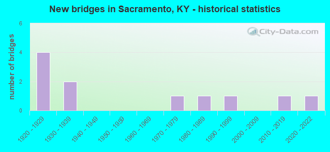
- New bridges - historical statistics
- 41920-1929
- 21930-1939
- 11970-1979
- 11980-1989
- 11990-1999
- 12010-2019
- 12020-2022

- Bridge Condition - Deck
- 12.5%Very good
- 75.0%Satisfactory
- 12.5%Poor

- Bridge Condition - Superstructure
- 12.5%Very good
- 37.5%Satisfactory
- 25.0%Fair
- 25.0%Poor

- Bridge Condition - Substructure
- 37.5%Good
- 50.0%Fair
- 12.5%Poor

- Bridge Condition - Channel
- 9.1%Very good
- 45.5%Good
- 36.4%Satisfactory
- 9.1%Poor

- Bridge Condition - Culverts
- 33.3%Very good
- 33.3%Fair
- 33.3%Poor
Find on map >> Show street view
Structure Number: 54B00033N, Location: ON MCLEAN - HOPKINS CL (Lat: 37.394722, Lng: -87.305556), Route carried "on" structure: State highway 85, Year Built: 1933, Status: Open, Structure Length: 8.78m (28.81ft), Average Daily Traffic: 1,337 (year 2020), Truck Traffic: 14%, Average Future Daily Traffic: 1,176 (year 2040), Design Load: H 15, Features Intersected: POND RIVER
Minimum Vertical Clearance: 30+ m (98+ ft), Kilometerpoint: 12.060, Lanes on structure: 2, Owner: State Highway Agency, Approaching Roadway Width: 5.2m (17.1ft), Material/Design: Concrete, Design/Construction: Tee Beam, Number Of Spans In Main Unit: 6, Length of Maximum Span: 13.7m (44.9ft), Curb or Sidewalk Widths: Left: 0.2m (0.7ft), Right: 0.2m (0.7ft), Curb-To-Curb Width: 6.0m (19.7ft), Out-to-Out Width: 7.1m (23.3ft)
Condition: Deck: Satisfactory, Superstructure: Fair, Substructure: Fair, Channel: Satisfactory, Operating Rating: 55.3 metric tons, Method Used To Determine Operating Rating: Load Factor (LF), Inventory Rating: 33.2 metric tons, Method Used To Determine Inventory Rating: Load Factor (LF), Structural Evaluation: Somewhat better than minimum adequacy, Deck Geometry: High priority of replacement, Waterway Adequacy: Somewhat better than minimum adequacy, Approach Roadway Alignment: Equal to present minimum criteria, Length Of Structure Improvement: 0.88m (2.89ft), Designated Inspection Frequency: Every 24 months, Inspection Date: May 2021, Bridge Improvement Cost: $756,000, Total Project Cost: $756,000, Deck Structure Type: Concrete Cast-file-Place, Wearing Surface/Protective System: Wearing Surface: Low Slump Concrete
Find on map >> Show street view
Structure Number: 54B00035N, Location: .80 MI WEST OF MCLEAN CL (Lat: 37.390278, Lng: -87.318611), Route carried "on" structure: State highway 85, Year Built: 1929, Year Reconstructed: 1993, Status: Open, Structure Length: 0.70m (2.30ft), Average Daily Traffic: 1,337 (year 2020), Truck Traffic: 14%, Average Future Daily Traffic: 1,176 (year 2040), Design Load: H 15, Features Intersected: UNNAME STREAM
Minimum Vertical Clearance: 30+ m (98+ ft), Kilometerpoint: 10.792, Lanes on structure: 2, Owner: State Highway Agency, Approaching Roadway Width: 5.5m (18.0ft), Material/Design: Concrete, Design/Construction: Culvert, Number Of Spans In Main Unit: 2, Length of Maximum Span: 3.0m (9.8ft)
Condition: Channel: Satisfactory, Culverts: Poor, Inventory Rating: 87.2 metric tons, Method Used To Determine Inventory Rating: Load Factor (LF), Structural Evaluation: Meets minimum limits, Waterway Adequacy: Meets minimum limits, Approach Roadway Alignment: Equal to present desirable criteria, Designated Inspection Frequency: Every 24 months, Inspection Date: May 2021
Find on map >> Show street view
Structure Number: 75B00025N, Location: .1 MI N OF JCT KY 1589 (Lat: 37.472222, Lng: -87.237778), Route carried "on" structure: State highway 81, Year Built: 1925, Status: Posted for load, Structure Length: 0.85m (2.79ft), Average Daily Traffic: 1,514 (year 2018), Truck Traffic: 13%, Average Future Daily Traffic: 1,332 (year 2038), Design Load: H 15, Features Intersected: SLOUGH
Minimum Vertical Clearance: 30+ m (98+ ft), Kilometerpoint: 11.071, Lanes on structure: 2, Owner: State Highway Agency, Approaching Roadway Width: 7.0m (23.0ft), Skew: 3 degrees, Material/Design: Concrete, Design/Construction: Tee Beam, Number Of Spans In Main Unit: 1, Length of Maximum Span: 7.3m (24.0ft), Curb or Sidewalk Widths: Left: 0.2m (0.7ft), Right: 0.2m (0.7ft), Curb-To-Curb Width: 6.6m (21.7ft), Out-to-Out Width: 7.0m (23.0ft)
Condition: Deck: Satisfactory, Superstructure: Fair, Substructure: Poor, Channel: Good, Operating Rating: 29.9 metric tons, Method Used To Determine Operating Rating: Load Factor (LF), Inventory Rating: 18.0 metric tons, Method Used To Determine Inventory Rating: Load Factor (LF), Structural Evaluation: Meets minimum limits, Deck Geometry: High priority of replacement, Waterway Adequacy: Better than present minimum criteria, Approach Roadway Alignment: Equal to present desirable criteria, Bridge Posting: Required (Relationship of Operating Rating to Maximum Legal Load: > 39.9% below), Length Of Structure Improvement: 0.09m (0.30ft), Designated Inspection Frequency: Every 12 months, Inspection Date: August 2021, Bridge Improvement Cost: $91,000, Total Project Cost: $90,000, Deck Structure Type: Concrete Cast-file-Place, Wearing Surface/Protective System: Wearing Surface: Bituminous
Find on map >> Show street view
Structure Number: 75B00027N, Location: 1.0 MI SOU. OF JCT KY 85 (Lat: 37.450278, Lng: -87.237778), Route carried "on" structure: State highway 81, Year Built: 1925, Status: Posted for load, Structure Length: 0.85m (2.79ft), Average Daily Traffic: 1,329 (year 2020), Truck Traffic: 13%, Average Future Daily Traffic: 1,169 (year 2040), Design Load: H 15, Features Intersected: UNNAME STREAM
Minimum Vertical Clearance: 30+ m (98+ ft), Kilometerpoint: 8.336, Lanes on structure: 2, Owner: State Highway Agency, Approaching Roadway Width: 7.0m (23.0ft), Skew: 3 degrees, Material/Design: Concrete, Design/Construction: Tee Beam, Number Of Spans In Main Unit: 1, Length of Maximum Span: 7.3m (24.0ft), Curb or Sidewalk Widths: Left: 0.2m (0.7ft), Right: 0.2m (0.7ft), Curb-To-Curb Width: 6.8m (22.3ft), Out-to-Out Width: 7.0m (23.0ft)
Condition: Deck: Satisfactory, Superstructure: Satisfactory, Substructure: Fair, Channel: Poor, Operating Rating: 30.8 metric tons, Method Used To Determine Operating Rating: Load Factor (LF), Inventory Rating: 18.4 metric tons, Method Used To Determine Inventory Rating: Load Factor (LF), Structural Evaluation: Somewhat better than minimum adequacy, Deck Geometry: High priority of corrective action, Waterway Adequacy: Better than present minimum criteria, Approach Roadway Alignment: Equal to present desirable criteria, Bridge Posting: Required (Relationship of Operating Rating to Maximum Legal Load: > 39.9% below), Length Of Structure Improvement: 0.09m (0.30ft), Designated Inspection Frequency: Every 12 months, Inspection Date: August 2021, Bridge Improvement Cost: $94,000, Roadway Improvement Cost: $30,000, Total Project Cost: $124,000, Deck Structure Type: Concrete Cast-file-Place, Wearing Surface/Protective System: Wearing Surface: Bituminous
Find on map >> Show street view
Structure Number: 75B00028N, Location: AT MUHLENBERG - MCLEAN CL (Lat: 37.386389, Lng: -87.251667), Route carried "on" structure: State highway 81, Year Built: 1925, Status: Posted for load, Structure Length: 1.01m (3.31ft), Average Daily Traffic: 2,979 (year 2019), Truck Traffic: 6%, Average Future Daily Traffic: 2,621 (year 2039), Design Load: H 15, Features Intersected: UNNAME STREAM
Minimum Vertical Clearance: 30+ m (98+ ft), Kilometerpoint: 0.002, Lanes on structure: 2, Owner: State Highway Agency, Approaching Roadway Width: 6.7m (22.0ft), Material/Design: Concrete, Design/Construction: Tee Beam, Number Of Spans In Main Unit: 1, Length of Maximum Span: 9.1m (29.9ft), Curb or Sidewalk Widths: Left: 0.5m (1.6ft), Right: 0.5m (1.6ft), Curb-To-Curb Width: 6.1m (20.0ft), Out-to-Out Width: 7.1m (23.3ft)
Condition: Deck: Poor, Superstructure: Poor, Substructure: Fair, Channel: Satisfactory, Operating Rating: 36.7 metric tons, Method Used To Determine Operating Rating: Load Factor (LF), Inventory Rating: 22.0 metric tons, Method Used To Determine Inventory Rating: Load Factor (LF), Structural Evaluation: Meets minimum limits, Deck Geometry: High priority of replacement, Waterway Adequacy: Equal to present minimum criteria, Approach Roadway Alignment: Equal to present desirable criteria, Bridge Posting: Required (Relationship of Operating Rating to Maximum Legal Load: > 39.9% below), Length Of Structure Improvement: 0.10m (0.33ft), Designated Inspection Frequency: Every 12 months, Inspection Date: August 2021, Bridge Improvement Cost: $111,000, Roadway Improvement Cost: $30,000, Total Project Cost: $141,000, Deck Structure Type: Concrete Cast-file-Place, Wearing Surface/Protective System: Wearing Surface: Bituminous
Find on map >> Show street view
Structure Number: 75B00029N, Location: .70 MI WEST OF JCT KY 81 (Lat: 37.399722, Lng: -87.272222), Route carried "on" structure: State highway 85, Year Built: 1933, Status: Open, Structure Length: 0.73m (2.40ft), Average Daily Traffic: 1,337 (year 2020), Truck Traffic: 14%, Average Future Daily Traffic: 1,176 (year 2040), Design Load: H 15, Features Intersected: UNNAMED BRANCH
Minimum Vertical Clearance: 30+ m (98+ ft), Kilometerpoint: 3.029, Lanes on structure: 2, Owner: State Highway Agency, Approaching Roadway Width: 6.4m (21.0ft), Skew: 3 degrees, Material/Design: Concrete, Design/Construction: Culvert, Number Of Spans In Main Unit: 2, Length of Maximum Span: 3.4m (11.2ft)
Condition: Channel: Good, Culverts: Fair, Operating Rating: 58.9 metric tons, Method Used To Determine Operating Rating: Load Factor (LF), Inventory Rating: 35.2 metric tons, Method Used To Determine Inventory Rating: Load Factor (LF), Structural Evaluation: Somewhat better than minimum adequacy, Waterway Adequacy: Better than present minimum criteria, Approach Roadway Alignment: Equal to present desirable criteria, Designated Inspection Frequency: Every 24 months, Inspection Date: August 2020
Find on map >> Show street view
Structure Number: 75B00069N, Location: 1.5 MI W OF JCT KY 81 (Lat: 37.459444, Lng: -87.267222), Route carried "on" structure: State highway 2385, Year Built: 1988, Status: Open, Structure Length: 1.55m (5.09ft), Average Daily Traffic: 144 (year 2020), Average Future Daily Traffic: 126 (year 2040), Design Load: HS 20, Features Intersected: POND DRAIN DITCH
Minimum Vertical Clearance: 30+ m (98+ ft), Kilometerpoint: 4.102, Lanes on structure: 2, Owner: State Highway Agency, Approaching Roadway Width: 6.7m (22.0ft), Material/Design: Prestressed concrete, Design/Construction: Box Beam or Girders - Multiple, Number Of Spans In Main Unit: 1, Length of Maximum Span: 14.3m (46.9ft), Curb or Sidewalk Widths: Left: 0.2m (0.7ft), Right: 0.2m (0.7ft), Curb-To-Curb Width: 6.9m (22.6ft), Out-to-Out Width: 7.5m (24.6ft)
Condition: Deck: Satisfactory, Superstructure: Poor, Substructure: Good, Channel: Good, Operating Rating: 55.8 metric tons, Method Used To Determine Operating Rating: Load Factor (LF), Inventory Rating: 33.5 metric tons, Method Used To Determine Inventory Rating: Load Factor (LF), Structural Evaluation: Meets minimum limits, Deck Geometry: Meets minimum limits, Waterway Adequacy: Somewhat better than minimum adequacy, Approach Roadway Alignment: Equal to present desirable criteria, Designated Inspection Frequency: Every 24 months, Inspection Date: August 2020, Deck Structure Type: Concrete Precast Panels, Wearing Surface/Protective System: Wearing Surface: Bituminous, Membrane: Preformed Fabric
Find on map >> Show street view
Structure Number: 75B00079N, Location: 0.75 MI WEST JCT KY 81 (Lat: 37.465833, Lng: -87.252500), Route carried "on" structure: State highway 2385, Year Built: 2018, Status: Open, Structure Length: 1.04m (3.41ft), Average Daily Traffic: 144 (year 2020), Average Future Daily Traffic: 126 (year 2040), Design Load: Greater than HL93, Features Intersected: BR OF POND DRAIN CR
Minimum Vertical Clearance: 30+ m (98+ ft), Kilometerpoint: 5.705, Lanes on structure: 2, Owner: State Highway Agency, Approaching Roadway Width: 6.9m (22.6ft), Material/Design: Concrete, Design/Construction: Culvert, Number Of Spans In Main Unit: 1, Length of Maximum Span: 10.4m (34.1ft)
Condition: Channel: Very good, Culverts: Very good, Operating Rating: 51.8 metric tons, Method Used To Determine Operating Rating: Load and Resistance Factor Rating (LRFR) rating reported by rating factor(RF) method using HL-93 loadings, Inventory Rating: 38.9 metric tons, Method Used To Determine Inventory Rating: Load and Resistance Factor Rating (LRFR) rating reported by rating factor(RF) method using HL-93 loadings, Structural Evaluation: Equal to present desirable criteria, Waterway Adequacy: Meets minimum limits, Approach Roadway Alignment: Equal to present desirable criteria, Designated Inspection Frequency: Every 24 months, Inspection Date: August 2020
Find on map >> Show street view
Structure Number: 75B00080N, Location: .60 MI S OF JCT KY 85 (Lat: 37.456389, Lng: -87.235000), Route carried "on" structure: State highway 81, Year Built: 2020, Status: Open, Structure Length: 1.01m (3.31ft), Average Daily Traffic: 1,621 (year 2019), Truck Traffic: 13%, Average Future Daily Traffic: 1,426 (year 2039), Design Load: Greater than HL93, Features Intersected: Slough
Minimum Vertical Clearance: 30+ m (98+ ft), Kilometerpoint: 9.106, Lanes on structure: 2, Owner: State Highway Agency, Approaching Roadway Width: 7.0m (23.0ft), Material/Design: Prestressed concrete, Design/Construction: Box Beam or Girders - Single/Spread, Number Of Spans In Main Unit: 1, Length of Maximum Span: 9.4m (30.8ft), Curb-To-Curb Width: 6.6m (21.7ft), Out-to-Out Width: 7.3m (24.0ft)
Condition: Deck: Very good, Superstructure: Very good, Substructure: Fair, Channel: Good, Operating Rating: 46.0 metric tons, Method Used To Determine Operating Rating: Load and Resistance Factor Rating (LRFR) rating reported by rating factor(RF) method using HL-93 loadings, Inventory Rating: 35.6 metric tons, Method Used To Determine Inventory Rating: Load and Resistance Factor Rating (LRFR) rating reported by rating factor(RF) method using HL-93 loadings, Structural Evaluation: Somewhat better than minimum adequacy, Deck Geometry: High priority of replacement, Waterway Adequacy: Equal to present minimum criteria, Approach Roadway Alignment: Equal to present desirable criteria, Designated Inspection Frequency: Every 24 months, Inspection Date: August 2020, Deck Structure Type: Concrete Cast-file-Place, Wearing Surface/Protective System: Wearing Surface: Monolithic Concrete, Deck Protection: Epoxy Coated Reinforcing
Find on map >> Show street view
Structure Number: 75C00026N, Location: .2 MI S JCT KY 2385 (Lat: 37.454444, Lng: -87.270278), Route carried "on" structure: County highway 1230, Year Built: 1993, Status: Open, Structure Length: 1.04m (3.41ft), Average Daily Traffic: 90 (year 2012), Average Future Daily Traffic: 78 (year 2032), Design Load: HS 25 or greater, Features Intersected: TRIB-POND DRAIN, Facility Carried by Structure: J.I. WEST ROAD
Minimum Vertical Clearance: 30+ m (98+ ft), Kilometerpoint: 0.518, Lanes on structure: 2, Owner: County Highway Agency, Approaching Roadway Width: 6.1m (20.0ft), Skew: 4 degrees, Material/Design: Prestressed concrete, Design/Construction: Box Beam or Girders - Multiple, Number Of Spans In Main Unit: 1, Length of Maximum Span: 8.5m (27.9ft), Curb-To-Curb Width: 6.9m (22.6ft), Out-to-Out Width: 7.4m (24.3ft)
Condition: Deck: Satisfactory, Superstructure: Satisfactory, Substructure: Good, Channel: Good, Operating Rating: 65.4 metric tons, Method Used To Determine Operating Rating: Load Factor (LF), Inventory Rating: 39.3 metric tons, Method Used To Determine Inventory Rating: Load Factor (LF), Structural Evaluation: Equal to present minimum criteria, Deck Geometry: Somewhat better than minimum adequacy, Waterway Adequacy: Meets minimum limits, Approach Roadway Alignment: Equal to present desirable criteria, Designated Inspection Frequency: Every 24 months, Inspection Date: Febuary 2020, Deck Structure Type: Concrete Precast Panels, Wearing Surface/Protective System: Wearing Surface: Monolithic Concrete, Deck Protection: Epoxy Coated Reinforcing
Find on map >> Show street view
Structure Number: 89C00024N, Location: 0.7 MI. N. JCT. KY 423 (Lat: 37.368333, Lng: -87.285556), Route carried "on" structure: County highway 1374, Year Built: 1979, Status: Open, Structure Length: 3.29m (10.79ft), Average Daily Traffic: 100 (year 2006), Average Future Daily Traffic: 100 (year 2026), Design Load: HS 20, Features Intersected: LOG CREEK, Facility Carried by Structure: MILLPORT SACRAMENT
Minimum Vertical Clearance: 30+ m (98+ ft), Kilometerpoint: 0.715, Lanes on structure: 2, Owner: County Highway Agency, Approaching Roadway Width: 5.5m (18.0ft), Skew: 1 degrees, Material/Design: Prestressed concrete, Design/Construction: Box Beam or Girders - Multiple, Number Of Spans In Main Unit: 3, Length of Maximum Span: 9.8m (32.2ft), Curb-To-Curb Width: 7.0m (23.0ft), Out-to-Out Width: 7.5m (24.6ft)
Condition: Deck: Satisfactory, Superstructure: Satisfactory, Substructure: Good, Channel: Satisfactory, Operating Rating: 93.2 metric tons, Method Used To Determine Operating Rating: Load Factor (LF), Inventory Rating: 55.9 metric tons, Method Used To Determine Inventory Rating: Load Factor (LF), Structural Evaluation: Equal to present minimum criteria, Deck Geometry: Somewhat better than minimum adequacy, Waterway Adequacy: Equal to present desirable criteria, Approach Roadway Alignment: Equal to present desirable criteria, Designated Inspection Frequency: Every 24 months, Inspection Date: Febuary 2021, Deck Structure Type: Concrete Precast Panels, Wearing Surface/Protective System: Wearing Surface: Monolithic Concrete