Bridge Statistics for Salem, South Dakota (SD)
Condition, Traffic, Stress, Structural Evaluation, Project Costs
- National Bridge Inventory (NBI) Statistics
- 16Number of bridges
- 144ft / 43.8mTotal length
- $755,000Total costs
- 44,623Total average daily traffic
- 9,459Total average daily truck traffic
- National Bridge Inventory (NBI) Registered Bridges for Salem
- No street view available for this location
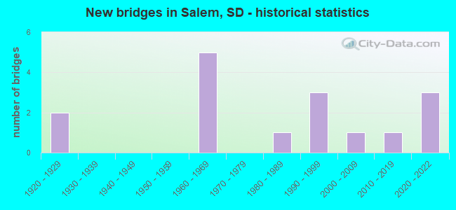
- New bridges - historical statistics
- 21920-1929
- 51960-1969
- 11980-1989
- 31990-1999
- 12000-2009
- 12010-2019
- 32020-2022


- Bridge Condition - Deck
- 18.2%Very good
- 18.2%Good
- 54.5%Satisfactory
- 9.1%Fair

- Bridge Condition - Superstructure
- 27.3%Very good
- 9.1%Good
- 54.5%Satisfactory
- 9.1%Fair

- Bridge Condition - Substructure
- 18.2%Very good
- 45.5%Good
- 36.4%Fair

- Bridge Condition - Channel
- 20.0%Excellent
- 40.0%Very good
- 20.0%Good
- 20.0%Satisfactory
Find on map >> Show street view
Structure Number: 4409205, Location: 3N & 1.7W of Salem (Lat: 43.775222, Lng: -97.425678), Route carried "on" structure: Other road , Year Built: 1993, Status: Open, Structure Length: 1.52m (4.99ft), Average Daily Traffic: 35 (year 2019), Truck Traffic: 2%, Average Future Daily Traffic: 35 (year 2032), Design Load: HS 20, Features Intersected: W. Fork of Vermillion Rv, Facility Carried by Structure: 249th Street
Minimum Vertical Clearance: 30+ m (98+ ft), Kilometerpoint: 0.000, Lanes on structure: 2, Owner: County Highway Agency, Approaching Roadway Width: 5.5m (18.0ft), Material/Design: Prestressed concrete, Design/Construction: Tee Beam, Number Of Spans In Main Unit: 1, Length of Maximum Span: 14.9m (48.9ft), Curb-To-Curb Width: 8.7m (28.5ft), Out-to-Out Width: 9.4m (30.8ft)
Condition: Deck: Satisfactory, Superstructure: Satisfactory, Substructure: Fair, Channel: Satisfactory, Operating Rating: 32.7 metric tons, Method Used To Determine Operating Rating: Field evaluation and documented engineering judgment, Inventory Rating: 24.5 metric tons, Method Used To Determine Inventory Rating: Field evaluation and documented engineering judgment, Structural Evaluation: Somewhat better than minimum adequacy, Deck Geometry: Better than present minimum criteria, Waterway Adequacy: Equal to present desirable criteria, Approach Roadway Alignment: Better than present minimum criteria, Designated Inspection Frequency: Every 24 months, Inspection Date: June 2020, Deck Structure Type: Concrete Precast Panels, Wearing Surface/Protective System: Wearing Surface: Monolithic Concrete
Find on map >> Show street view
Structure Number: 4409306, Location: 2N & 1.7W of Salem (Lat: 43.760717, Lng: -97.422469), Route carried "on" structure: Other road , Year Built: 2005, Status: Open, Structure Length: 1.52m (4.99ft), Average Daily Traffic: 85 (year 2019), Truck Traffic: 2%, Average Future Daily Traffic: 105 (year 2032), Design Load: HS 20+Mod, Features Intersected: W. Fork of Vermillion Rv, Facility Carried by Structure: 250th Street
Minimum Vertical Clearance: 30+ m (98+ ft), Kilometerpoint: 0.000, Lanes on structure: 2, Owner: County Highway Agency, Approaching Roadway Width: 8.5m (27.9ft), Material/Design: Prestressed concrete, Design/Construction: Tee Beam, Number Of Spans In Main Unit: 1, Length of Maximum Span: 14.7m (48.2ft), Curb-To-Curb Width: 8.7m (28.5ft), Out-to-Out Width: 9.3m (30.5ft)
Condition: Deck: Good, Superstructure: Good, Substructure: Good, Channel: Excellent, Operating Rating: 32.7 metric tons, Method Used To Determine Operating Rating: Field evaluation and documented engineering judgment, Inventory Rating: 24.5 metric tons, Method Used To Determine Inventory Rating: Field evaluation and documented engineering judgment, Structural Evaluation: Equal to present minimum criteria, Deck Geometry: Better than present minimum criteria, Waterway Adequacy: Superior to present desirable criteria, Approach Roadway Alignment: Equal to present desirable criteria, Designated Inspection Frequency: Every 24 months, Inspection Date: June 2020, Deck Structure Type: Concrete Precast Panels, Wearing Surface/Protective System: Wearing Surface: Gravel
Find on map >> Show street view
Structure Number: 4409508, Location: 1.5W of Salem (Lat: 43.731622, Lng: -97.421239), Route carried "on" structure: County highway , Year Built: 1925, Year Reconstructed: 1975, Status: Open, Structure Length: 1.08m (3.54ft), Average Daily Traffic: 157 (year 2019), Truck Traffic: 2%, Average Future Daily Traffic: 157 (year 2032), Features Intersected: W. Fork of Vermillion Rv, Facility Carried by Structure: 252nd Street
Minimum Vertical Clearance: 30+ m (98+ ft), Kilometerpoint: 0.000, Lanes on structure: 2, Owner: County Highway Agency, Approaching Roadway Width: 5.5m (18.0ft), Material/Design: Concrete continuous, Design/Construction: Slab, Number Of Spans In Main Unit: 2, Length of Maximum Span: 4.8m (15.7ft), Curb-To-Curb Width: 10.7m (35.1ft), Out-to-Out Width: 10.7m (35.1ft)
Condition: Deck: Fair, Superstructure: Fair, Substructure: Fair, Channel: Satisfactory, Operating Rating: 32.7 metric tons, Method Used To Determine Operating Rating: Field evaluation and documented engineering judgment, Inventory Rating: 24.5 metric tons, Method Used To Determine Inventory Rating: Field evaluation and documented engineering judgment, Structural Evaluation: Somewhat better than minimum adequacy, Deck Geometry: Better than present minimum criteria, Waterway Adequacy: Equal to present desirable criteria, Approach Roadway Alignment: Equal to present desirable criteria, Designated Inspection Frequency: Every 24 months, Inspection Date: June 2020, Deck Structure Type: Concrete Cast-file-Place, Wearing Surface/Protective System: Wearing Surface: Bituminous
Find on map >> Show street view
Structure Number: 4409509, Location: 1.5 W JCT US 81 (Lat: 43.717069, Lng: -97.417589), Route carried "on" structure: State highway 38, Year Built: 2021, Status: Open, Structure Length: 6.90m (22.64ft), Average Daily Traffic: 926 (year 2021), Truck Traffic: 11%, Average Future Daily Traffic: 1,386 (year 2041), Design Load: HL 93, Features Intersected: WEST FORK VERMILLION RV
Minimum Vertical Clearance: 30+ m (98+ ft), Kilometerpoint: 532.387, Lanes on structure: 2, Owner: State Highway Agency, Approaching Roadway Width: 11.0m (36.1ft), Material/Design: Concrete continuous, Design/Construction: Slab, Number Of Spans In Main Unit: 5, Length of Maximum Span: 14.9m (48.9ft), Curb-To-Curb Width: 11.0m (36.1ft), Out-to-Out Width: 11.8m (38.7ft)
Condition: Deck: Very good, Superstructure: Very good, Substructure: Very good, Channel: Very good, Operating Rating: 46.4 metric tons, Method Used To Determine Operating Rating: Load and Resistance Factor (LRFR), Inventory Rating: 35.7 metric tons, Method Used To Determine Inventory Rating: Load and Resistance Factor (LRFR), Structural Evaluation: Equal to present desirable criteria, Deck Geometry: Better than present minimum criteria, Waterway Adequacy: Superior to present desirable criteria, Approach Roadway Alignment: Superior to present desirable criteria, Designated Inspection Frequency: Every 24 months, Inspection Date: December 2021, Deck Structure Type: Concrete Cast-file-Place, Wearing Surface/Protective System: Wearing Surface: Integral Concrete, Deck Protection: Epoxy Coated Reinforcing
Find on map >> Show street view
Structure Number: 440971, Location: 1S & 1.3W of Salem (Lat: 43.702558, Lng: -97.413281), Route carried "on" structure: Other road , Year Built: 1980, Status: Open, Structure Length: 1.52m (4.99ft), Average Daily Traffic: 40 (year 2019), Truck Traffic: 2%, Average Future Daily Traffic: 40 (year 2032), Design Load: HS 20, Features Intersected: W. Fork of Vermillion Rv, Facility Carried by Structure: 254th Street
Minimum Vertical Clearance: 30+ m (98+ ft), Kilometerpoint: 0.000, Lanes on structure: 2, Owner: County Highway Agency, Approaching Roadway Width: 7.3m (24.0ft), Material/Design: Prestressed concrete, Design/Construction: Tee Beam, Number Of Spans In Main Unit: 1, Length of Maximum Span: 14.9m (48.9ft), Curb-To-Curb Width: 9.2m (30.2ft), Out-to-Out Width: 9.4m (30.8ft)
Condition: Deck: Satisfactory, Superstructure: Satisfactory, Substructure: Fair, Channel: Very good, Operating Rating: 32.7 metric tons, Method Used To Determine Operating Rating: Field evaluation and documented engineering judgment, Inventory Rating: 24.5 metric tons, Method Used To Determine Inventory Rating: Field evaluation and documented engineering judgment, Structural Evaluation: Somewhat better than minimum adequacy, Deck Geometry: Better than present minimum criteria, Waterway Adequacy: Equal to present desirable criteria, Approach Roadway Alignment: Better than present minimum criteria, Designated Inspection Frequency: Every 24 months, Inspection Date: June 2020, Deck Structure Type: Concrete Precast Panels, Wearing Surface/Protective System: Wearing Surface: Gravel
Find on map >> Show street view
Structure Number: 4410111, Location: 2S & 0.9W of Salem (Lat: 43.688069, Lng: -97.407800), Route carried "on" structure: Other road , Year Built: 2019, Status: Open, Structure Length: 1.96m (6.43ft), Average Daily Traffic: 45 (year 2019), Truck Traffic: 2%, Average Future Daily Traffic: 45 (year 2032), Design Load: HL 93, Features Intersected: W. Fork of Vermillion Rv, Facility Carried by Structure: 255th Street
Minimum Vertical Clearance: 30+ m (98+ ft), Kilometerpoint: 0.000, Lanes on structure: 2, Owner: County Highway Agency, Approaching Roadway Width: 5.5m (18.0ft), Skew: 2 degrees, Material/Design: Concrete continuous, Design/Construction: Culvert, Number Of Spans In Main Unit: 4, Length of Maximum Span: 4.7m (15.4ft)
Condition: Channel: Very good, Culverts: Very good, Operating Rating: 57.1 metric tons, Method Used To Determine Operating Rating: Load and Resistance Factor (LRFR), Inventory Rating: 44.0 metric tons, Method Used To Determine Inventory Rating: Load and Resistance Factor (LRFR), Structural Evaluation: Equal to present desirable criteria, Waterway Adequacy: Superior to present desirable criteria, Approach Roadway Alignment: Superior to present desirable criteria, Designated Inspection Frequency: Every 24 months, Inspection Date: June 2020
Find on map >> Show street view
Structure Number: 44104125, Location: 0.6 W US 81 INTERCH (Lat: 43.666489, Lng: -97.399936), Route carried "on" structure: Interstate 90, Year Built: 1964, Status: Open, Structure Length: 4.62m (15.16ft), Average Daily Traffic: 5,995 (year 2021), Truck Traffic: 22%, Average Future Daily Traffic: 9,046 (year 2041), Design Load: HS 20+Mod, Features Intersected: WEST FORK VERMILLION RV
Minimum Vertical Clearance: 30+ m (98+ ft), Kilometerpoint: 584.964, Lanes on structure: 2, Base Highway Network: Yes, Owner: State Highway Agency, Approaching Roadway Width: 11.6m (38.1ft), Material/Design: Concrete continuous, Design/Construction: Slab, Number Of Spans In Main Unit: 5, Length of Maximum Span: 9.3m (30.5ft), Curb-To-Curb Width: 9.1m (29.9ft), Out-to-Out Width: 10.5m (34.4ft)
Condition: Deck: Satisfactory, Superstructure: Satisfactory, Substructure: Good, Channel: Good, Operating Rating: 71.9 metric tons, Method Used To Determine Operating Rating: Load Factor (LF), Inventory Rating: 43.1 metric tons, Method Used To Determine Inventory Rating: Load Factor (LF), Structural Evaluation: Equal to present minimum criteria, Deck Geometry: High priority of replacement, Waterway Adequacy: Equal to present desirable criteria, Approach Roadway Alignment: Equal to present desirable criteria, Length Of Structure Improvement: 4.63m (15.19ft), Designated Inspection Frequency: Every 24 months, Inspection Date: March 2021, Bridge Improvement Cost: $630,000, Roadway Improvement Cost: $63,000, Total Project Cost: $755,000, Deck Structure Type: Concrete Cast-file-Place, Wearing Surface/Protective System: Wearing Surface: Low Slump Concrete
Find on map >> Show street view
Structure Number: 44104126, Location: 0.6 W US 81 INTERCH (Lat: 43.666236, Lng: -97.399717), Route carried "on" structure: Interstate 90, Year Built: 2021, Status: Open, Structure Length: 7.75m (25.43ft), Average Daily Traffic: 5,995 (year 2021), Truck Traffic: 22%, Average Future Daily Traffic: 9,046 (year 2041), Design Load: HL 93, Features Intersected: WEST FORK VERMILLION RV
Minimum Vertical Clearance: 30+ m (98+ ft), Kilometerpoint: 584.964, Lanes on structure: 2, Base Highway Network: Yes, Owner: State Highway Agency, Approaching Roadway Width: 12.2m (40.0ft), Material/Design: Steel continuous, Design/Construction: Stringer/Multi-beam, Number Of Spans In Main Unit: 3, Length of Maximum Span: 29.3m (96.1ft), Curb-To-Curb Width: 12.2m (40.0ft), Out-to-Out Width: 13.0m (42.7ft)
Condition: Deck: Very good, Superstructure: Very good, Substructure: Very good, Channel: Very good, Operating Rating: 39.8 metric tons, Method Used To Determine Operating Rating: Load and Resistance Factor (LRFR), Inventory Rating: 30.7 metric tons, Method Used To Determine Inventory Rating: Load and Resistance Factor (LRFR), Structural Evaluation: Better than present minimum criteria, Deck Geometry: Better than present minimum criteria, Waterway Adequacy: Superior to present desirable criteria, Approach Roadway Alignment: Superior to present desirable criteria, Designated Inspection Frequency: Every 24 months, Inspection Date: November 2021, Deck Structure Type: Concrete Cast-file-Place, Wearing Surface/Protective System: Wearing Surface: Integral Concrete, Deck Protection: Epoxy Coated Reinforcing
Find on map >> Show street view
Structure Number: 4410713, Location: 4S & 0.3E of Salem (Lat: 43.659097, Lng: -97.394558), Route carried "on" structure: County highway , Year Built: 1925, Year Reconstructed: 1975, Status: Open, Structure Length: 1.37m (4.49ft), Average Daily Traffic: 155 (year 2019), Truck Traffic: 2%, Average Future Daily Traffic: 155 (year 2032), Features Intersected: W. Fork of Vermillion Rv, Facility Carried by Structure: 257th Street
Minimum Vertical Clearance: 30+ m (98+ ft), Kilometerpoint: 0.000, Lanes on structure: 2, Owner: County Highway Agency, Approaching Roadway Width: 5.5m (18.0ft), Material/Design: Prestressed concrete, Design/Construction: Tee Beam, Number Of Spans In Main Unit: 1, Length of Maximum Span: 13.4m (44.0ft), Curb-To-Curb Width: 9.2m (30.2ft), Out-to-Out Width: 9.2m (30.2ft)
Condition: Deck: Satisfactory, Superstructure: Satisfactory, Substructure: Fair, Channel: Good, Operating Rating: 32.7 metric tons, Method Used To Determine Operating Rating: Field evaluation and documented engineering judgment, Inventory Rating: 24.5 metric tons, Method Used To Determine Inventory Rating: Field evaluation and documented engineering judgment, Structural Evaluation: Somewhat better than minimum adequacy, Deck Geometry: Equal to present minimum criteria, Waterway Adequacy: Better than present minimum criteria, Approach Roadway Alignment: Better than present minimum criteria, Designated Inspection Frequency: Every 24 months, Inspection Date: June 2020, Deck Structure Type: Concrete Precast Panels, Wearing Surface/Protective System: Wearing Surface: Monolithic Concrete
Find on map >> Show street view
Structure Number: 44110125, Location: US 81 INTERCHANGE (Lat: 43.666578, Lng: -97.388258), Route carried "on" structure: US 81, Year Built: 1993, Status: Open, Structure Length: 7.50m (24.61ft), Average Daily Traffic: 2,075 (year 2021), Truck Traffic: 17%, Average Future Daily Traffic: 3,106 (year 2041), Design Load: HS 20+Mod, Features Intersected: I090
Minimum Vertical Clearance: 30+ m (98+ ft), Kilometerpoint: 93.165, Lanes on structure: 2, Lanes under structure: 4, Owner: State Highway Agency, Approaching Roadway Width: 12.2m (40.0ft), Material/Design: Prestressed concrete continuous, Design/Construction: Stringer/Multi-beam, Number Of Spans In Main Unit: 2, Length of Maximum Span: 37.2m (122.0ft), Curb-To-Curb Width: 12.2m (40.0ft), Out-to-Out Width: 13.0m (42.7ft)
Condition: Deck: Good, Superstructure: Very good, Substructure: Good, Operating Rating: 82.5 metric tons, Method Used To Determine Operating Rating: Load Factor (LF), Inventory Rating: 49.4 metric tons, Method Used To Determine Inventory Rating: Load Factor (LF), Structural Evaluation: Better than present minimum criteria, Deck Geometry: Equal to present minimum criteria, Underclear: Somewhat better than minimum adequacy, Approach Roadway Alignment: Equal to present desirable criteria, Designated Inspection Frequency: Every 24 months, Inspection Date: April 2021, Deck Structure Type: Concrete Cast-file-Place, Wearing Surface/Protective System: Wearing Surface: Monolithic Concrete, Deck Protection: Epoxy Coated Reinforcing
Find on map >> Show street view
Structure Number: 44124125, Location: 1.4 E US 81 INTERCH (Lat: 43.666261, Lng: -97.359881), Route carried "on" structure: Interstate 90, Year Built: 2021, Status: Open, Structure Length: 0.76m (2.49ft), Average Daily Traffic: 6,085 (year 2020), Truck Traffic: 21%, Average Future Daily Traffic: 8,379 (year 2040), Design Load: HL 93, Features Intersected: TRIB W VERMILLION RV
Minimum Vertical Clearance: 30+ m (98+ ft), Kilometerpoint: 588.135, Lanes on structure: 4, Base Highway Network: Yes, Owner: State Highway Agency, Approaching Roadway Width: 11.6m (38.1ft), Material/Design: Concrete continuous, Design/Construction: Culvert, Number Of Spans In Main Unit: 2, Length of Maximum Span: 3.7m (12.1ft)
Condition: Channel: Excellent, Culverts: Very good, Operating Rating: 56.2 metric tons, Method Used To Determine Operating Rating: Load and Resistance Factor (LRFR), Inventory Rating: 43.4 metric tons, Method Used To Determine Inventory Rating: Load and Resistance Factor (LRFR), Structural Evaluation: Equal to present desirable criteria, Waterway Adequacy: Superior to present desirable criteria, Approach Roadway Alignment: Superior to present desirable criteria, Designated Inspection Frequency: Every 24 months, Inspection Date: November 2021
Find on map >> Show street view
Structure Number: 44130125, Location: 2 E US 81 INTERCH (Lat: 43.666472, Lng: -97.347686), Route carried "on" structure: Interstate 90, Year Built: 1964, Status: Open, Structure Length: 3.63m (11.91ft), Average Daily Traffic: 6,225 (year 2021), Truck Traffic: 24%, Average Future Daily Traffic: 9,394 (year 2041), Design Load: HS 20+Mod, Features Intersected: 448 AVE
Minimum Vertical Clearance: 30+ m (98+ ft), Kilometerpoint: 589.116, Lanes on structure: 2, Lanes under structure: 2, Base Highway Network: Yes, Owner: State Highway Agency, Approaching Roadway Width: 11.6m (38.1ft), Material/Design: Concrete continuous, Design/Construction: Slab, Number Of Spans In Main Unit: 3, Length of Maximum Span: 13.1m (43.0ft), Curb-To-Curb Width: 11.6m (38.1ft), Out-to-Out Width: 12.9m (42.3ft)
Condition: Deck: Satisfactory, Superstructure: Satisfactory, Substructure: Good, Operating Rating: 65.5 metric tons, Method Used To Determine Operating Rating: Load Factor (LF), Inventory Rating: 39.2 metric tons, Method Used To Determine Inventory Rating: Load Factor (LF), Structural Evaluation: Equal to present minimum criteria, Deck Geometry: Equal to present minimum criteria, Underclear: Somewhat better than minimum adequacy, Approach Roadway Alignment: Equal to present desirable criteria, Designated Inspection Frequency: Every 24 months, Inspection Date: March 2020, Deck Structure Type: Concrete Cast-file-Place, Wearing Surface/Protective System: Wearing Surface: Low Slump Concrete
Find on map >> Show street view
Structure Number: 44130126, Location: 2 E US 81 INTERCH (Lat: 43.666228, Lng: -97.347681), Route carried "on" structure: Interstate 90, Year Built: 1964, Status: Open, Structure Length: 3.63m (11.91ft), Average Daily Traffic: 6,225 (year 2021), Truck Traffic: 24%, Average Future Daily Traffic: 9,394 (year 2041), Design Load: HS 20+Mod, Features Intersected: 448 AVE
Minimum Vertical Clearance: 30+ m (98+ ft), Kilometerpoint: 589.116, Lanes on structure: 2, Lanes under structure: 2, Base Highway Network: Yes, Owner: State Highway Agency, Approaching Roadway Width: 11.6m (38.1ft), Material/Design: Concrete continuous, Design/Construction: Slab, Number Of Spans In Main Unit: 3, Length of Maximum Span: 13.1m (43.0ft), Curb-To-Curb Width: 11.6m (38.1ft), Out-to-Out Width: 12.9m (42.3ft)
Condition: Deck: Satisfactory, Superstructure: Satisfactory, Substructure: Good, Operating Rating: 65.0 metric tons, Method Used To Determine Operating Rating: Load Factor (LF), Inventory Rating: 38.9 metric tons, Method Used To Determine Inventory Rating: Load Factor (LF), Structural Evaluation: Equal to present minimum criteria, Deck Geometry: Equal to present minimum criteria, Underclear: Somewhat better than minimum adequacy, Approach Roadway Alignment: Equal to present desirable criteria, Designated Inspection Frequency: Every 24 months, Inspection Date: March 2020, Deck Structure Type: Concrete Cast-file-Place, Wearing Surface/Protective System: Wearing Surface: Low Slump Concrete
Find on map >> Show street view
Structure Number: 44110125, Location: US 81 INTERCHANGE (Lat: 43.666578, Lng: -97.388258), Route carried "under" structure: Interstate 90, Year Built: 1993, Structure Length: 0. m, Average Daily Traffic: 10,490 (year 2020), Truck Traffic: 20%, Features Intersected: I090, Facility Carried by Structure: US081
Minimum Vertical Clearance: 5.03m (16.50ft), Kilometerpoint: 585.833, Lanes on structure: 2, Lanes under structure: 4, Material/Design: Prestressed concrete continuous, Design/Construction: Stringer/Multi-beam, Length of Maximum Span: 37.2m (122.0ft)
Find on map >> Show street view
Structure Number: 44130125, Location: 2 E US 81 INTERCH (Lat: 43.666472, Lng: -97.347686), Route carried "under" structure: County highway , Year Built: 1964, Structure Length: 0. m, Average Daily Traffic: 45 (year 2020), Features Intersected: 448 AVE, Facility Carried by Structure: I090 W
Minimum Vertical Clearance: 5.16m (16.93ft), Kilometerpoint: 0.000, Lanes on structure: 2, Lanes under structure: 2, Material/Design: Concrete continuous, Design/Construction: Slab, Length of Maximum Span: 13.1m (43.0ft)
Find on map >> Show street view
Structure Number: 44130126, Location: 2 E US 81 INTERCH (Lat: 43.666228, Lng: -97.347681), Route carried "under" structure: County highway , Year Built: 1964, Structure Length: 0. m, Average Daily Traffic: 45 (year 2020), Features Intersected: 448 AVE, Facility Carried by Structure: I090 E
Minimum Vertical Clearance: 5.36m (17.59ft), Kilometerpoint: 0.000, Lanes on structure: 2, Lanes under structure: 2, Material/Design: Concrete continuous, Design/Construction: Slab, Length of Maximum Span: 13.1m (43.0ft)