Bridge Statistics for Sanborn, North Dakota (ND)
Condition, Traffic, Stress, Structural Evaluation, Project Costs
- National Bridge Inventory (NBI) Statistics
- 15Number of bridges
- 102ft / 31.4mTotal length
- 71,420Total average daily traffic
- 13,497Total average daily truck traffic
- National Bridge Inventory (NBI) Registered Bridges for Sanborn
- No street view available for this location
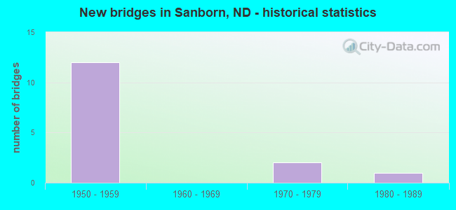
- New bridges - historical statistics
- 121950-1959
- 21970-1979
- 11980-1989

- Reconstructed bridges - Historical Statistics
- 31970-1979
- 01980-1989
- 01990-1999
- 12000-2009


- Bridge Condition - Deck
- 71.4%Good
- 14.3%Satisfactory
- 14.3%Fair

- Bridge Condition - Superstructure
- 28.6%Very good
- 28.6%Good
- 42.9%Satisfactory

- Bridge Condition - Substructure
- 85.7%Good
- 14.3%Fair
Find on map >> Show street view
Structure Number: 1078696, Location: 2 NORTH OF I-94 (Lat: 46.939358, Lng: -98.195186), Route carried "on" structure: State highway 1, Year Built: 1988, Status: Open, Structure Length: 4.24m (13.91ft), Average Daily Traffic: 1,250 (year 2019), Truck Traffic: 15%, Average Future Daily Traffic: 1,250 (year 2039), Design Load: HS 20, Features Intersected: SANBORN BNRR SEPARATION
Minimum Vertical Clearance: 30+ m (98+ ft), Kilometerpoint: 126.622, Lanes on structure: 2, Base Highway Network: Yes, Owner: State Highway Agency, Approaching Roadway Width: 12.2m (40.0ft), Skew: 1 degrees, Material/Design: Prestressed concrete continuous, Design/Construction: Box Beam or Girders - Single/Spread, Number Of Spans In Main Unit: 3, Length of Maximum Span: 16.2m (53.1ft), Curb-To-Curb Width: 12.2m (40.0ft), Out-to-Out Width: 13.0m (42.7ft)
Condition: Deck: Good, Superstructure: Very good, Substructure: Good, Inventory Rating: 54.5 metric tons, Method Used To Determine Inventory Rating: Load Factor (LF), Structural Evaluation: Better than present minimum criteria, Deck Geometry: Better than present minimum criteria, Underclear: Equal to present desirable criteria, Approach Roadway Alignment: Better than present minimum criteria, Designated Inspection Frequency: Every 24 months, Inspection Date: September 2021, Deck Structure Type: Concrete Cast-file-Place, Wearing Surface/Protective System: Wearing Surface: Monolithic Concrete, Deck Protection: Epoxy Coated Reinforcing
Find on map >> Show street view
Structure Number: 94279636, Location: 4 WEST OF ND 1 NORTH (Lat: 46.906667, Lng: -98.271667), Route carried "on" structure: County highway , Year Built: 1958, Status: Open, Structure Length: 6.40m (21.00ft), Average Daily Traffic: 20 (year 2020), Average Future Daily Traffic: 20 (year 2040), Design Load: HS 20, Features Intersected: I-94/WEST SANBORN SEP, Facility Carried by Structure: COUNTY HIGHWAY
Minimum Vertical Clearance: 30+ m (98+ ft), Kilometerpoint: 0.000, Lanes on structure: 2, Lanes under structure: 4, Owner: State Highway Agency, Approaching Roadway Width: 5.2m (17.1ft), Material/Design: Prestressed concrete, Design/Construction: Stringer/Multi-beam, Number Of Spans In Main Unit: 4, Length of Maximum Span: 18.0m (59.1ft), Curb-To-Curb Width: 7.3m (24.0ft), Out-to-Out Width: 8.8m (28.9ft)
Condition: Deck: Good, Superstructure: Good, Substructure: Good, Operating Rating: 83.5 metric tons, Method Used To Determine Operating Rating: Load Factor (LF), Inventory Rating: 37.6 metric tons, Method Used To Determine Inventory Rating: Load Factor (LF), Structural Evaluation: Better than present minimum criteria, Deck Geometry: Equal to present minimum criteria, Underclear: Meets minimum limits, Approach Roadway Alignment: Equal to present minimum criteria, Designated Inspection Frequency: Every 24 months, Inspection Date: November 2021, Deck Structure Type: Concrete Cast-file-Place, Wearing Surface/Protective System: Wearing Surface: Monolithic Concrete
Find on map >> Show street view
Structure Number: 9428164, Location: 2 WEST OF ND 1 NORTH (Lat: 46.906667, Lng: -98.228331), Route carried "on" structure: County highway 211, Year Built: 1958, Year Reconstructed: 2005, Status: Open, Structure Length: 6.40m (21.00ft), Average Daily Traffic: 350 (year 2020), Truck Traffic: 15%, Average Future Daily Traffic: 350 (year 2040), Design Load: H 15, Features Intersected: I-94/SANBORN INTERCHANGE
Minimum Vertical Clearance: 30+ m (98+ ft), Kilometerpoint: 32.985, Lanes on structure: 2, Lanes under structure: 4, Owner: State Highway Agency, Approaching Roadway Width: 7.0m (23.0ft), Material/Design: Prestressed concrete, Design/Construction: Stringer/Multi-beam, Number Of Spans In Main Unit: 4, Length of Maximum Span: 18.0m (59.1ft), Curb-To-Curb Width: 7.3m (24.0ft), Out-to-Out Width: 8.1m (26.6ft)
Condition: Deck: Fair, Superstructure: Satisfactory, Substructure: Fair, Operating Rating: 45.3 metric tons, Method Used To Determine Operating Rating: Load Factor (LF), Inventory Rating: 23.8 metric tons, Method Used To Determine Inventory Rating: Load Factor (LF), Structural Evaluation: Somewhat better than minimum adequacy, Deck Geometry: Somewhat better than minimum adequacy, Underclear: Meets minimum limits, Approach Roadway Alignment: Somewhat better than minimum adequacy, Designated Inspection Frequency: Every 24 months, Inspection Date: November 2021, Deck Structure Type: Concrete Cast-file-Place, Wearing Surface/Protective System: Wearing Surface: Low Slump Concrete
Find on map >> Show street view
Structure Number: 94283139 L, Location: JCT I 94 & ND 1 NORTH (Lat: 46.906667, Lng: -98.195000), Route carried "on" structure: Interstate 94, Year Built: 1958, Year Reconstructed: 1979, Status: Open, Structure Length: 3.81m (12.50ft), Average Daily Traffic: 4,450 (year 2020), Truck Traffic: 19%, Average Future Daily Traffic: 4,450 (year 2040), Design Load: H 20, Features Intersected: ND1/ROGERS INTERCHANGE
Minimum Vertical Clearance: 30+ m (98+ ft), Kilometerpoint: 455.571, Lanes on structure: 2, Lanes under structure: 2, Base Highway Network: Yes, Owner: State Highway Agency, Approaching Roadway Width: 11.6m (38.1ft), Skew: 10 degrees, Material/Design: Concrete continuous, Design/Construction: Tee Beam, Number Of Spans In Main Unit: 3, Length of Maximum Span: 14.0m (45.9ft), Curb-To-Curb Width: 12.2m (40.0ft), Out-to-Out Width: 13.6m (44.6ft)
Condition: Deck: Good, Superstructure: Satisfactory, Substructure: Good, Operating Rating: 59.7 metric tons, Method Used To Determine Operating Rating: Load Factor (LF), Inventory Rating: 35.7 metric tons, Method Used To Determine Inventory Rating: Load Factor (LF), Structural Evaluation: Equal to present minimum criteria, Deck Geometry: Better than present minimum criteria, Underclear: Meets minimum limits, Approach Roadway Alignment: Better than present minimum criteria, Designated Inspection Frequency: Every 24 months, Inspection Date: November 2021, Deck Structure Type: Concrete Cast-file-Place, Wearing Surface/Protective System: Wearing Surface: Low Slump Concrete
Find on map >> Show street view
Structure Number: 94283139 R, Location: JCT I 94 & ND 1 NORTH (Lat: 46.906597, Lng: -98.196036), Route carried "on" structure: Interstate 94, Year Built: 1976, Status: Open, Structure Length: 3.81m (12.50ft), Average Daily Traffic: 4,450 (year 2020), Truck Traffic: 19%, Average Future Daily Traffic: 4,450 (year 2040), Design Load: HS 20, Features Intersected: ND1/ROGERS INTERCHANGE
Minimum Vertical Clearance: 30+ m (98+ ft), Kilometerpoint: 455.571, Lanes on structure: 2, Lanes under structure: 2, Base Highway Network: Yes, Owner: State Highway Agency, Approaching Roadway Width: 11.6m (38.1ft), Skew: 10 degrees, Material/Design: Prestressed concrete continuous, Design/Construction: Box Beam or Girders - Single/Spread, Number Of Spans In Main Unit: 3, Length of Maximum Span: 14.3m (46.9ft), Curb-To-Curb Width: 12.2m (40.0ft), Out-to-Out Width: 13.6m (44.6ft)
Condition: Deck: Good, Superstructure: Very good, Substructure: Good, Operating Rating: 89.8 metric tons, Method Used To Determine Operating Rating: Load Factor (LF), Inventory Rating: 56.6 metric tons, Method Used To Determine Inventory Rating: Load Factor (LF), Structural Evaluation: Better than present minimum criteria, Deck Geometry: Better than present minimum criteria, Underclear: Meets minimum limits, Approach Roadway Alignment: Better than present minimum criteria, Designated Inspection Frequency: Every 24 months, Inspection Date: November 2021, Deck Structure Type: Concrete Cast-file-Place, Wearing Surface/Protective System: Wearing Surface: Low Slump Concrete
Find on map >> Show street view
Structure Number: 94284584 L, Location: 1 EAST OF ND 1 NORTH (Lat: 46.906667, Lng: -98.165000), Route carried "on" structure: Interstate 94, Year Built: 1958, Year Reconstructed: 1979, Status: Open, Structure Length: 3.35m (10.99ft), Average Daily Traffic: 4,450 (year 2020), Truck Traffic: 19%, Average Future Daily Traffic: 4,450 (year 2040), Design Load: HS 20, Features Intersected: CO HWY/HOBART LAKE SEP.
Minimum Vertical Clearance: 30+ m (98+ ft), Kilometerpoint: 457.896, Lanes on structure: 2, Lanes under structure: 2, Base Highway Network: Yes, Owner: State Highway Agency, Approaching Roadway Width: 11.6m (38.1ft), Skew: 10 degrees, Material/Design: Concrete continuous, Design/Construction: Slab, Number Of Spans In Main Unit: 3, Length of Maximum Span: 12.5m (41.0ft), Curb-To-Curb Width: 11.9m (39.0ft), Out-to-Out Width: 12.8m (42.0ft)
Condition: Deck: Good, Superstructure: Good, Substructure: Good, Operating Rating: 58.5 metric tons, Method Used To Determine Operating Rating: Load Factor (LF), Inventory Rating: 31.6 metric tons, Method Used To Determine Inventory Rating: Load Factor (LF), Structural Evaluation: Better than present minimum criteria, Deck Geometry: Equal to present minimum criteria, Underclear: Somewhat better than minimum adequacy, Approach Roadway Alignment: Better than present minimum criteria, Designated Inspection Frequency: Every 24 months, Inspection Date: November 2021, Deck Structure Type: Concrete Cast-file-Place, Wearing Surface/Protective System: Wearing Surface: Low Slump Concrete
Find on map >> Show street view
Structure Number: 94284584 R, Location: 1 EAST OF ND 1 NORTH (Lat: 46.906667, Lng: -98.165000), Route carried "on" structure: Interstate 94, Year Built: 1958, Year Reconstructed: 1979, Status: Open, Structure Length: 3.35m (10.99ft), Average Daily Traffic: 4,450 (year 2020), Truck Traffic: 19%, Average Future Daily Traffic: 4,450 (year 2040), Design Load: HS 20, Features Intersected: CO HWY/HOBART LAKE SEP
Minimum Vertical Clearance: 30+ m (98+ ft), Kilometerpoint: 457.896, Lanes on structure: 2, Lanes under structure: 2, Base Highway Network: Yes, Owner: State Highway Agency, Approaching Roadway Width: 11.6m (38.1ft), Skew: 10 degrees, Material/Design: Concrete continuous, Design/Construction: Slab, Number Of Spans In Main Unit: 3, Length of Maximum Span: 12.5m (41.0ft), Curb-To-Curb Width: 12.2m (40.0ft), Out-to-Out Width: 13.8m (45.3ft)
Condition: Deck: Satisfactory, Superstructure: Satisfactory, Substructure: Good, Operating Rating: 58.5 metric tons, Method Used To Determine Operating Rating: Load Factor (LF), Inventory Rating: 31.6 metric tons, Method Used To Determine Inventory Rating: Load Factor (LF), Structural Evaluation: Equal to present minimum criteria, Deck Geometry: Better than present minimum criteria, Underclear: Equal to present minimum criteria, Approach Roadway Alignment: Better than present minimum criteria, Designated Inspection Frequency: Every 24 months, Inspection Date: November 2021, Deck Structure Type: Concrete Cast-file-Place, Wearing Surface/Protective System: Wearing Surface: Low Slump Concrete
Find on map >> Show street view
Structure Number: 94279636, Location: 4 WEST OF ND 1 NORTH (Lat: 46.906667, Lng: -98.271667), Route carried "under" structure: Interstate 94, Year Built: 1958, Structure Length: 0. m, Average Daily Traffic: 8,500 (year 2011), Truck Traffic: 19%, Features Intersected: I-94/WEST SANBORN SEP, Facility Carried by Structure: COUNTY HIGHWAY
Minimum Vertical Clearance: 5.04m (16.54ft), Kilometerpoint: 450.031, Lanes on structure: 2, Lanes under structure: 2, Material/Design: Prestressed concrete, Design/Construction: Stringer/Multi-beam, Length of Maximum Span: 18.0m (59.1ft)
Find on map >> Show street view
Structure Number: 94279636, Location: 4 WEST OF ND 1 NORTH (Lat: 46.906667, Lng: -98.271667), Route carried "under" structure: Interstate 94, Year Built: 1958, Structure Length: 0. m, Average Daily Traffic: 8,500 (year 2011), Truck Traffic: 19%, Features Intersected: I-94/WEST SANBORN SEP, Facility Carried by Structure: COUNTY HIGHWAY
Minimum Vertical Clearance: 5.00m (16.40ft), Kilometerpoint: 450.031, Lanes on structure: 2, Lanes under structure: 2, Material/Design: Prestressed concrete, Design/Construction: Stringer/Multi-beam, Length of Maximum Span: 18.0m (59.1ft)
Find on map >> Show street view
Structure Number: 9428164, Location: 2 WEST OF ND 1 NORTH (Lat: 46.906667, Lng: -98.228331), Route carried "under" structure: Interstate 94, Year Built: 1958, Structure Length: 0. m, Average Daily Traffic: 8,600 (year 2011), Truck Traffic: 19%, Features Intersected: I-94/SANBORN INTERCHANGE, Facility Carried by Structure: COUNTY HIWAY 0211
Minimum Vertical Clearance: 5.04m (16.54ft), Kilometerpoint: 453.256, Lanes on structure: 2, Lanes under structure: 2, Material/Design: Prestressed concrete, Design/Construction: Stringer/Multi-beam, Length of Maximum Span: 18.0m (59.1ft)
Find on map >> Show street view
Structure Number: 9428164, Location: 2 WEST OF ND 1 NORTH (Lat: 46.906667, Lng: -98.228331), Route carried "under" structure: Interstate 94, Year Built: 1958, Structure Length: 0. m, Average Daily Traffic: 8,600 (year 2011), Truck Traffic: 19%, Features Intersected: I-94/SANBORN INTERCHANGE, Facility Carried by Structure: COUNTY HIWAY 0211
Minimum Vertical Clearance: 5.03m (16.50ft), Kilometerpoint: 453.256, Lanes on structure: 2, Lanes under structure: 2, Material/Design: Prestressed concrete, Design/Construction: Stringer/Multi-beam, Length of Maximum Span: 18.0m (59.1ft)
Find on map >> Show street view
Structure Number: 94283139 L, Location: JCT I 94 & ND 1 NORTH (Lat: 46.906667, Lng: -98.195000), Route carried "under" structure: State highway 1, Year Built: 1958, Structure Length: 0. m, Average Daily Traffic: 4,450 (year 2011), Truck Traffic: 19%, Features Intersected: ND1/ROGERS INTERCHANGE, Facility Carried by Structure: INTERSTATE 94
Minimum Vertical Clearance: 4.86m (15.94ft), Kilometerpoint: 122.991, Lanes on structure: 2, Lanes under structure: 2, Material/Design: Concrete continuous, Design/Construction: Tee Beam, Length of Maximum Span: 14.0m (45.9ft)
Find on map >> Show street view
Structure Number: 94283139 R, Location: JCT I 94 & ND 1 NORTH (Lat: 46.906597, Lng: -98.196036), Route carried "under" structure: State highway 1, Year Built: 1976, Structure Length: 0. m, Average Daily Traffic: 4,450 (year 2011), Truck Traffic: 19%, Features Intersected: ND1/ROGERS INTERCHANGE, Facility Carried by Structure: INTERSTATE 94
Minimum Vertical Clearance: 4.97m (16.31ft), Kilometerpoint: 122.991, Lanes on structure: 2, Lanes under structure: 2, Material/Design: Prestressed concrete continuous, Design/Construction: Box Beam or Girders - Single/Spread, Length of Maximum Span: 14.3m (46.9ft)
Find on map >> Show street view
Structure Number: 94284584 L, Location: 1 EAST OF ND 1 NORTH (Lat: 46.906667, Lng: -98.165000), Route carried "under" structure: Other road , Year Built: 1958, Structure Length: 0. m, Average Daily Traffic: 4,450 (year 2011), Truck Traffic: 19%, Features Intersected: CO HWY/HOBART LAKE SEP., Facility Carried by Structure: INTERSTATE 94
Minimum Vertical Clearance: 4.44m (14.57ft), Kilometerpoint: 0.000, Lanes on structure: 2, Lanes under structure: 2, Material/Design: Concrete continuous, Design/Construction: Slab, Length of Maximum Span: 12.5m (41.0ft)
Find on map >> Show street view
Structure Number: 94284584 R, Location: 1 EAST OF ND 1 NORTH (Lat: 46.906667, Lng: -98.165000), Route carried "under" structure: Other road , Year Built: 1958, Structure Length: 0. m, Average Daily Traffic: 4,450 (year 2011), Truck Traffic: 19%, Features Intersected: CO HWY/HOBART LAKE SEP, Facility Carried by Structure: INTERSTATE 94
Minimum Vertical Clearance: 4.44m (14.57ft), Kilometerpoint: 0.000, Lanes on structure: 2, Lanes under structure: 2, Material/Design: Concrete continuous, Design/Construction: Slab, Length of Maximum Span: 12.5m (41.0ft)