Bridge Statistics for Saylorville, Iowa (IA)
Condition, Traffic, Stress, Structural Evaluation, Project Costs
- National Bridge Inventory (NBI) Statistics
- 16Number of bridges
- 154ft / 47.5mTotal length
- 270,990Total average daily traffic
- 48,624Total average daily truck traffic
- National Bridge Inventory (NBI) Registered Bridges for Saylorville
- No street view available for this location
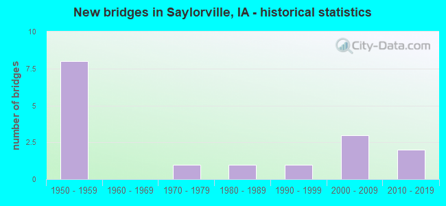
- New bridges - historical statistics
- 81950-1959
- 11970-1979
- 11980-1989
- 11990-1999
- 32000-2009
- 22010-2019

- Reconstructed bridges - Historical Statistics
- 31980-1989
- 31990-1999


- Bridge Condition - Deck
- 25.0%Good
- 25.0%Satisfactory
- 50.0%Fair

- Bridge Condition - Superstructure
- 12.5%Very good
- 75.0%Good
- 12.5%Satisfactory

- Bridge Condition - Substructure
- 12.5%Very good
- 12.5%Good
- 50.0%Satisfactory
- 25.0%Fair

- Bridge Condition - Channel
- 8.3%Very good
- 75.0%Good
- 16.7%Satisfactory

- Bridge Condition - Culverts
- 16.7%Very good
- 66.7%Good
- 16.7%Satisfactory
Find on map >> Show street view
Structure Number: 4153, Location: 0.8 MI. W OF JCT. IA 415 (Lat: 41.649383, Lng: -93.634856), Route carried "on" structure: Interstate 80, Year Built: 1958, Year Reconstructed: 1990, Status: Open, Structure Length: 3.41m (11.19ft), Average Daily Traffic: 42,800 (year 2020), Truck Traffic: 19%, Average Future Daily Traffic: 42,800 (year 2040), Design Load: HS 20, Features Intersected: DRAINAGE DITCH
Minimum Vertical Clearance: 30+ m (98+ ft), Kilometerpoint: 216.325, Lanes on structure: 3, Base Highway Network: Yes, Owner: State Highway Agency, Approaching Roadway Width: 21.0m (68.9ft), Material/Design: Prestressed concrete, Design/Construction: Stringer/Multi-beam, Number Of Spans In Main Unit: 3, Length of Maximum Span: 12.2m (40.0ft), Curb-To-Curb Width: 19.1m (62.7ft), Out-to-Out Width: 20.4m (66.9ft)
Condition: Deck: Fair, Superstructure: Good, Substructure: Satisfactory, Channel: Satisfactory, Operating Rating: 60.5 metric tons, Method Used To Determine Operating Rating: Load Factor (LF), Inventory Rating: 32.1 metric tons, Method Used To Determine Inventory Rating: Load Factor (LF), Structural Evaluation: Equal to present minimum criteria, Deck Geometry: Superior to present desirable criteria, Waterway Adequacy: Better than present minimum criteria, Approach Roadway Alignment: Equal to present desirable criteria, Designated Inspection Frequency: Every 24 months, Inspection Date: September 2020, Deck Structure Type: Concrete Cast-file-Place, Wearing Surface/Protective System: Wearing Surface: Low Slump Concrete, Deck Protection: Epoxy Coated Reinforcing
Find on map >> Show street view
Structure Number: 4154, Location: 0.8 mi. W of Jct. IA #415 (Lat: 41.649561, Lng: -93.634447), Route carried "on" structure: Interstate 80, Year Built: 1958, Year Reconstructed: 1990, Status: Open, Structure Length: 3.41m (11.19ft), Average Daily Traffic: 42,800 (year 2020), Truck Traffic: 19%, Average Future Daily Traffic: 42,800 (year 2040), Design Load: HS 20, Features Intersected: DRAINAGE DITCH
Minimum Vertical Clearance: 30+ m (98+ ft), Kilometerpoint: 276.781, Lanes on structure: 3, Owner: State Highway Agency, Approaching Roadway Width: 21.0m (68.9ft), Material/Design: Prestressed concrete, Design/Construction: Stringer/Multi-beam, Number Of Spans In Main Unit: 3, Length of Maximum Span: 12.2m (40.0ft), Curb-To-Curb Width: 19.1m (62.7ft), Out-to-Out Width: 20.4m (66.9ft)
Condition: Deck: Satisfactory, Superstructure: Good, Substructure: Fair, Channel: Good, Operating Rating: 66.6 metric tons, Method Used To Determine Operating Rating: Load Factor (LF), Inventory Rating: 40.0 metric tons, Method Used To Determine Inventory Rating: Load Factor (LF), Structural Evaluation: Somewhat better than minimum adequacy, Deck Geometry: Superior to present desirable criteria, Waterway Adequacy: Better than present minimum criteria, Approach Roadway Alignment: Equal to present desirable criteria, Designated Inspection Frequency: Every 24 months, Inspection Date: September 2020, Deck Structure Type: Concrete Cast-file-Place, Wearing Surface/Protective System: Wearing Surface: Low Slump Concrete, Deck Protection: Epoxy Coated Reinforcing
Find on map >> Show street view
Structure Number: 4155, Location: 0.5 MI. W OF JCT. 415 (Lat: 41.649389, Lng: -93.629150), Route carried "on" structure: Interstate 80, Year Built: 1958, Year Reconstructed: 1991, Status: Open, Structure Length: 5.18m (16.99ft), Average Daily Traffic: 39,150 (year 2020), Truck Traffic: 20%, Average Future Daily Traffic: 39,150 (year 2041), Design Load: HS 20, Features Intersected: SAYLOR CREEK
Minimum Vertical Clearance: 30+ m (98+ ft), Kilometerpoint: 216.800, Lanes on structure: 3, Base Highway Network: Yes, Owner: State Highway Agency, Approaching Roadway Width: 20.7m (67.9ft), Material/Design: Prestressed concrete, Design/Construction: Stringer/Multi-beam, Number Of Spans In Main Unit: 3, Length of Maximum Span: 16.8m (55.1ft), Curb-To-Curb Width: 19.0m (62.3ft), Out-to-Out Width: 20.4m (66.9ft)
Condition: Deck: Fair, Superstructure: Good, Substructure: Satisfactory, Channel: Satisfactory, Operating Rating: 65.9 metric tons, Method Used To Determine Operating Rating: Load Factor (LF), Inventory Rating: 23.4 metric tons, Method Used To Determine Inventory Rating: Load Factor (LF), Structural Evaluation: Somewhat better than minimum adequacy, Deck Geometry: Superior to present desirable criteria, Waterway Adequacy: Better than present minimum criteria, Approach Roadway Alignment: Equal to present desirable criteria, Designated Inspection Frequency: Every 24 months, Inspection Date: May 2021, Deck Structure Type: Concrete Cast-file-Place, Wearing Surface/Protective System: Wearing Surface: Low Slump Concrete, Deck Protection: Epoxy Coated Reinforcing
Find on map >> Show street view
Structure Number: 4156, Location: 0.5 mi. W of Jct. IA 415 (Lat: 41.649569, Lng: -93.628508), Route carried "on" structure: Interstate 80, Year Built: 1958, Year Reconstructed: 1990, Status: Open, Structure Length: 5.18m (16.99ft), Average Daily Traffic: 39,150 (year 2020), Truck Traffic: 20%, Average Future Daily Traffic: 39,150 (year 2040), Design Load: HS 20, Features Intersected: SAYLOR CREEK
Minimum Vertical Clearance: 30+ m (98+ ft), Kilometerpoint: 276.286, Lanes on structure: 3, Owner: State Highway Agency, Approaching Roadway Width: 26.2m (86.0ft), Material/Design: Prestressed concrete, Design/Construction: Stringer/Multi-beam, Number Of Spans In Main Unit: 3, Length of Maximum Span: 16.8m (55.1ft), Curb-To-Curb Width: 19.0m (62.3ft), Out-to-Out Width: 20.3m (66.6ft)
Condition: Deck: Satisfactory, Superstructure: Satisfactory, Substructure: Satisfactory, Channel: Good, Operating Rating: 63.9 metric tons, Method Used To Determine Operating Rating: Load Factor (LF), Inventory Rating: 25.7 metric tons, Method Used To Determine Inventory Rating: Load Factor (LF), Structural Evaluation: Equal to present minimum criteria, Deck Geometry: Superior to present desirable criteria, Waterway Adequacy: Better than present minimum criteria, Approach Roadway Alignment: Equal to present desirable criteria, Designated Inspection Frequency: Every 24 months, Inspection Date: August 2020, Deck Structure Type: Concrete Cast-file-Place, Wearing Surface/Protective System: Wearing Surface: Low Slump Concrete
Find on map >> Show street view
Structure Number: 4157, Location: 0.4 mi. W of Jct. IA 415 (Lat: 41.649389, Lng: -93.628164), Route carried "on" structure: Interstate 80, Year Built: 1958, Year Reconstructed: 1991, Status: Open, Structure Length: 4.30m (14.11ft), Average Daily Traffic: 39,150 (year 2020), Truck Traffic: 20%, Average Future Daily Traffic: 39,150 (year 2041), Design Load: HS 20, Features Intersected: 6TH AVE
Minimum Vertical Clearance: 30+ m (98+ ft), Kilometerpoint: 216.882, Lanes on structure: 3, Lanes under structure: 2, Base Highway Network: Yes, Owner: State Highway Agency, Approaching Roadway Width: 20.7m (67.9ft), Material/Design: Prestressed concrete, Design/Construction: Stringer/Multi-beam, Number Of Spans In Main Unit: 3, Length of Maximum Span: 15.9m (52.2ft), Curb-To-Curb Width: 19.0m (62.3ft), Out-to-Out Width: 20.3m (66.6ft)
Condition: Deck: Fair, Superstructure: Good, Substructure: Fair, Operating Rating: 63.9 metric tons, Method Used To Determine Operating Rating: Load Factor (LF), Inventory Rating: 29.0 metric tons, Method Used To Determine Inventory Rating: Load Factor (LF), Structural Evaluation: Somewhat better than minimum adequacy, Deck Geometry: Superior to present desirable criteria, Underclear: Equal to present minimum criteria, Approach Roadway Alignment: Equal to present desirable criteria, Designated Inspection Frequency: Every 24 months, Inspection Date: May 2021, Deck Structure Type: Concrete Cast-file-Place, Wearing Surface/Protective System: Wearing Surface: Low Slump Concrete, Deck Protection: Epoxy Coated Reinforcing
Find on map >> Show street view
Structure Number: 4158, Location: 0.4 mi. W of Jct. IA 415 (Lat: 41.649569, Lng: -93.627647), Route carried "on" structure: Interstate 80, Year Built: 1958, Year Reconstructed: 1991, Status: Open, Structure Length: 4.30m (14.11ft), Average Daily Traffic: 39,150 (year 2020), Truck Traffic: 20%, Average Future Daily Traffic: 39,150 (year 2041), Design Load: HS 20, Features Intersected: 6TH AVE
Minimum Vertical Clearance: 30+ m (98+ ft), Kilometerpoint: 276.215, Lanes on structure: 3, Lanes under structure: 2, Owner: State Highway Agency, Approaching Roadway Width: 20.7m (67.9ft), Material/Design: Prestressed concrete, Design/Construction: Stringer/Multi-beam, Number Of Spans In Main Unit: 3, Length of Maximum Span: 15.5m (50.9ft), Curb-To-Curb Width: 19.0m (62.3ft), Out-to-Out Width: 20.3m (66.6ft)
Condition: Deck: Fair, Superstructure: Very good, Substructure: Satisfactory, Operating Rating: 65.0 metric tons, Method Used To Determine Operating Rating: Load Factor (LF), Inventory Rating: 30.5 metric tons, Method Used To Determine Inventory Rating: Load Factor (LF), Structural Evaluation: Equal to present minimum criteria, Deck Geometry: Superior to present desirable criteria, Underclear: Equal to present minimum criteria, Approach Roadway Alignment: Equal to present desirable criteria, Designated Inspection Frequency: Every 24 months, Inspection Date: May 2021, Deck Structure Type: Concrete Cast-file-Place, Wearing Surface/Protective System: Wearing Surface: Low Slump Concrete, Deck Protection: Epoxy Coated Reinforcing
Find on map >> Show street view
Structure Number: 281341, Location: 079240338 (Lat: 41.673239, Lng: -93.628744), Route carried "on" structure: County highway , Year Built: 2003, Status: Open, Structure Length: 1.74m (5.71ft), Average Daily Traffic: 3,850 (year 2016), Average Future Daily Traffic: 3,850 (year 2040), Design Load: HS 20, Features Intersected: SAYLOR CREEK, Facility Carried by Structure: FM
Minimum Vertical Clearance: 30+ m (98+ ft), Kilometerpoint: 4.142, Lanes on structure: 2, Owner: County Highway Agency, Approaching Roadway Width: 11.0m (36.1ft), Material/Design: Concrete continuous, Design/Construction: Culvert, Number Of Spans In Main Unit: 3, Length of Maximum Span: 3.7m (12.1ft)
Condition: Channel: Good, Culverts: Good, Operating Rating: 59.6 metric tons, Method Used To Determine Operating Rating: Load Factor (LF), Inventory Rating: 35.6 metric tons, Method Used To Determine Inventory Rating: Load Factor (LF), Structural Evaluation: Better than present minimum criteria, Waterway Adequacy: Equal to present desirable criteria, Approach Roadway Alignment: Equal to present minimum criteria, Designated Inspection Frequency: Every 24 months, Inspection Date: June 2020
Find on map >> Show street view
Structure Number: 281351, Location: 079240351 (Lat: 41.680358, Lng: -93.621108), Route carried "on" structure: County highway , Year Built: 1972, Status: Open, Structure Length: 1.31m (4.30ft), Average Daily Traffic: 5,200 (year 2016), Truck Traffic: 3%, Average Future Daily Traffic: 5,200 (year 2041), Design Load: HS 20, Features Intersected: SMALL STREAM, Facility Carried by Structure: FM
Minimum Vertical Clearance: 30+ m (98+ ft), Kilometerpoint: 4.212, Lanes on structure: 2, Owner: County Highway Agency, Approaching Roadway Width: 10.4m (34.1ft), Skew: 3 degrees, Material/Design: Concrete continuous, Design/Construction: Culvert, Number Of Spans In Main Unit: 3, Length of Maximum Span: 3.7m (12.1ft)
Condition: Channel: Good, Culverts: Satisfactory, Operating Rating: 48.2 metric tons, Method Used To Determine Operating Rating: Load Factor (LF), Inventory Rating: 28.8 metric tons, Method Used To Determine Inventory Rating: Load Factor (LF), Structural Evaluation: Equal to present minimum criteria, Waterway Adequacy: Better than present minimum criteria, Approach Roadway Alignment: Equal to present desirable criteria, Length Of Structure Improvement: 4.30m (14.11ft), Designated Inspection Frequency: Every 24 months, Inspection Date: March 2021, Bridge Improvement Cost: $65,000, Roadway Improvement Cost: $10,000
Find on map >> Show street view
Structure Number: 281361, Location: 079240421 (Lat: 41.680342, Lng: -93.639514), Route carried "on" structure: County highway , Year Built: 2005, Status: Open, Structure Length: 1.22m (4.00ft), Average Daily Traffic: 3,770 (year 2016), Average Future Daily Traffic: 3,770 (year 2041), Design Load: HS 20, Features Intersected: DRAINAGE DITCH, Facility Carried by Structure: FM
Minimum Vertical Clearance: 30+ m (98+ ft), Kilometerpoint: 3.034, Lanes on structure: 2, Owner: County Highway Agency, Approaching Roadway Width: 10.4m (34.1ft), Material/Design: Concrete continuous, Design/Construction: Culvert, Number Of Spans In Main Unit: 3, Length of Maximum Span: 3.7m (12.1ft)
Condition: Channel: Good, Culverts: Good, Operating Rating: 59.8 metric tons, Method Used To Determine Operating Rating: Load Factor (LF), Inventory Rating: 35.7 metric tons, Method Used To Determine Inventory Rating: Load Factor (LF), Structural Evaluation: Better than present minimum criteria, Waterway Adequacy: Better than present minimum criteria, Approach Roadway Alignment: Equal to present desirable criteria, Designated Inspection Frequency: Every 24 months, Inspection Date: March 2021
Find on map >> Show street view
Structure Number: 281421, Location: 079241501 (Lat: 41.658767, Lng: -93.629689), Route carried "on" structure: County highway , Year Built: 2003, Status: Open, Structure Length: 1.43m (4.69ft), Average Daily Traffic: 960 (year 2016), Truck Traffic: 29%, Average Future Daily Traffic: 960 (year 2041), Design Load: HS 20, Features Intersected: CREEK, Facility Carried by Structure: FM
Minimum Vertical Clearance: 30+ m (98+ ft), Kilometerpoint: 2.990, Lanes on structure: 2, Owner: County Highway Agency, Approaching Roadway Width: 11.6m (38.1ft), Material/Design: Concrete continuous, Design/Construction: Culvert, Number Of Spans In Main Unit: 3, Length of Maximum Span: 3.7m (12.1ft)
Condition: Channel: Good, Culverts: Good, Operating Rating: 60.0 metric tons, Method Used To Determine Operating Rating: Load Factor (LF), Inventory Rating: 35.9 metric tons, Method Used To Determine Inventory Rating: Load Factor (LF), Structural Evaluation: Better than present minimum criteria, Waterway Adequacy: Equal to present desirable criteria, Approach Roadway Alignment: Better than present minimum criteria, Designated Inspection Frequency: Every 24 months, Inspection Date: March 2021
Find on map >> Show street view
Structure Number: 282041, Location: 080243204 (Lat: 41.700186, Lng: -93.668386), Route carried "on" structure: County highway , Year Built: 1981, Status: Open, Structure Length: 5.00m (16.40ft), Average Daily Traffic: 1,760 (year 2016), Average Future Daily Traffic: 1,760 (year 2041), Design Load: HS 20, Features Intersected: ROCK CREEK, Facility Carried by Structure: FM
Minimum Vertical Clearance: 30+ m (98+ ft), Kilometerpoint: 0.480, Lanes on structure: 2, Owner: County Highway Agency, Approaching Roadway Width: 12.2m (40.0ft), Material/Design: Prestressed concrete continuous, Design/Construction: Stringer/Multi-beam, Number Of Spans In Main Unit: 3, Length of Maximum Span: 18.6m (61.0ft), Curb-To-Curb Width: 9.1m (29.9ft), Out-to-Out Width: 10.2m (33.5ft)
Condition: Deck: Good, Superstructure: Good, Substructure: Good, Channel: Good, Operating Rating: 46.3 metric tons, Method Used To Determine Operating Rating: Load Factor (LF), Inventory Rating: 27.7 metric tons, Method Used To Determine Inventory Rating: Load Factor (LF), Structural Evaluation: Equal to present minimum criteria, Deck Geometry: Somewhat better than minimum adequacy, Waterway Adequacy: Better than present minimum criteria, Approach Roadway Alignment: Equal to present desirable criteria, Length Of Structure Improvement: 16.40m (53.81ft), Designated Inspection Frequency: Every 24 months, Inspection Date: June 2021, Bridge Improvement Cost: $15,000, Roadway Improvement Cost: $10,000, Deck Structure Type: Concrete Cast-file-Place, Wearing Surface/Protective System: Wearing Surface: Monolithic Concrete
Find on map >> Show street view
Structure Number: 282061, Location: 080243409 (Lat: 41.692389, Lng: -93.641286), Route carried "on" structure: County highway , Year Built: 2015, Status: Open, Structure Length: 0.98m (3.22ft), Average Daily Traffic: 40 (year 2016), Average Future Daily Traffic: 40 (year 2042), Design Load: HL 93, Features Intersected: CREEK, Facility Carried by Structure: NW 72ND PLACE
Minimum Vertical Clearance: 30+ m (98+ ft), Kilometerpoint: 0.459, Lanes on structure: 2, Owner: County Highway Agency, Approaching Roadway Width: 10.4m (34.1ft), Material/Design: Concrete continuous, Design/Construction: Culvert, Number Of Spans In Main Unit: 3, Length of Maximum Span: 3.0m (9.8ft)
Condition: Channel: Very good, Culverts: Very good, Operating Rating: 58.6 metric tons, Method Used To Determine Operating Rating: Load and Resistance Factor Rating (LRFR) rating reported by rating factor(RF) method using HL-93 loadings, Inventory Rating: 45.4 metric tons, Method Used To Determine Inventory Rating: Load and Resistance Factor Rating (LRFR) rating reported by rating factor(RF) method using HL-93 loadings, Structural Evaluation: Equal to present desirable criteria, Waterway Adequacy: Equal to present desirable criteria, Approach Roadway Alignment: Equal to present desirable criteria, Designated Inspection Frequency: Every 24 months, Inspection Date: January 2022
Find on map >> Show street view
Structure Number: 36574, Location: 0107924 (Lat: 41.658536, Lng: -93.634928), Route carried "on" structure: County highway , Year Built: 2011, Status: Open, Structure Length: 1.15m (3.77ft), Average Daily Traffic: 960 (year 2016), Truck Traffic: 29%, Average Future Daily Traffic: 960 (year 2040), Design Load: HS 20, Features Intersected: DRAINAGE DISTRICT 1, Facility Carried by Structure: NW 54TH AVE
Minimum Vertical Clearance: 30+ m (98+ ft), Kilometerpoint: 2.548, Lanes on structure: 2, Owner: County Highway Agency, Approaching Roadway Width: 12.2m (40.0ft), Material/Design: Concrete continuous, Design/Construction: Culvert, Number Of Spans In Main Unit: 3, Length of Maximum Span: 3.7m (12.1ft)
Condition: Channel: Good, Culverts: Good, Operating Rating: 45.0 metric tons, Method Used To Determine Operating Rating: Load Factor (LF), Inventory Rating: 26.9 metric tons, Method Used To Determine Inventory Rating: Load Factor (LF), Structural Evaluation: Equal to present minimum criteria, Approach Roadway Alignment: Equal to present minimum criteria, Designated Inspection Frequency: Every 24 months, Inspection Date: June 2020
Find on map >> Show street view
Structure Number: 601295, Location: 1.9 MILES N OF JCT IA 160 (Lat: 41.703158, Lng: -93.657719), Route carried "on" structure: State highway 415, Year Built: 1993, Status: Open, Structure Length: 8.87m (29.10ft), Average Daily Traffic: 8,200 (year 2020), Truck Traffic: 4%, Average Future Daily Traffic: 8,200 (year 2040), Design Load: HS 20, Features Intersected: ROCK CREEK
Minimum Vertical Clearance: 30+ m (98+ ft), Kilometerpoint: 11.454, Lanes on structure: 2, Base Highway Network: Yes, Owner: State Highway Agency, Approaching Roadway Width: 13.4m (44.0ft), Material/Design: Prestressed concrete, Design/Construction: Stringer/Multi-beam, Number Of Spans In Main Unit: 3, Length of Maximum Span: 29.0m (95.1ft), Curb-To-Curb Width: 13.4m (44.0ft), Out-to-Out Width: 14.4m (47.2ft)
Condition: Deck: Good, Superstructure: Good, Substructure: Very good, Channel: Good, Operating Rating: 90.5 metric tons, Method Used To Determine Operating Rating: Load Factor (LF), Inventory Rating: 43.9 metric tons, Method Used To Determine Inventory Rating: Load Factor (LF), Structural Evaluation: Better than present minimum criteria, Deck Geometry: Equal to present minimum criteria, Waterway Adequacy: Equal to present desirable criteria, Approach Roadway Alignment: Better than present minimum criteria, Designated Inspection Frequency: Every 24 months, Inspection Date: March 2020, Deck Structure Type: Concrete Cast-file-Place, Wearing Surface/Protective System: Wearing Surface: Monolithic Concrete, Deck Protection: Epoxy Coated Reinforcing
Find on map >> Show street view
Structure Number: 4157, Location: 0.4 mi. W of Jct. IA 415 (Lat: 41.649389, Lng: -93.628164), Route carried "under" structure: County highway , Year Built: 1958, Structure Length: 0. m, Average Daily Traffic: 2,025 (year 2016), Features Intersected: 6TH AVE, Facility Carried by Structure: NB I-35,EB I-80
Minimum Vertical Clearance: 30+ m (98+ ft), Kilometerpoint: 1.460, Lanes on structure: 3, Lanes under structure: 2, Material/Design: Prestressed concrete, Design/Construction: Stringer/Multi-beam, Length of Maximum Span: 15.9m (52.2ft)
Find on map >> Show street view
Structure Number: 4158, Location: 0.4 mi. W of Jct. IA 415 (Lat: 41.649569, Lng: -93.627647), Route carried "under" structure: County highway , Year Built: 1958, Structure Length: 0. m, Average Daily Traffic: 2,025 (year 2016), Features Intersected: 6TH AVE, Facility Carried by Structure: SB I-35,WB I-80
Minimum Vertical Clearance: 30+ m (98+ ft), Kilometerpoint: 1.481, Lanes on structure: 3, Lanes under structure: 2, Material/Design: Prestressed concrete, Design/Construction: Stringer/Multi-beam, Length of Maximum Span: 15.5m (50.9ft)