Bridge Statistics for Seagrove, North Carolina (NC)
Condition, Traffic, Stress, Structural Evaluation, Project Costs
- National Bridge Inventory (NBI) Statistics
- 28Number of bridges
- 220ft / 67.5mTotal length
- 89,480Total average daily traffic
- 18,332Total average daily truck traffic
- National Bridge Inventory (NBI) Registered Bridges for Seagrove
- No street view available for this location
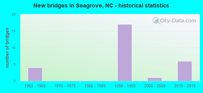
- New bridges - historical statistics
- 41960-1969
- 171990-1999
- 12000-2009
- 62010-2019


- Bridge Condition - Deck
- 28.6%Very good
- 42.9%Good
- 28.6%Satisfactory

- Bridge Condition - Superstructure
- 28.6%Very good
- 50.0%Good
- 14.3%Satisfactory
- 7.1%Fair

- Bridge Condition - Substructure
- 28.6%Very good
- 42.9%Good
- 14.3%Satisfactory
- 14.3%Fair

- Bridge Condition - Channel
- 85.7%Good
- 14.3%Fair

- Bridge Condition - Culverts
- 20.0%Good
- 60.0%Satisfactory
- 20.0%Fair
Find on map >> Show street view
Structure Number: 1230214, Location: 0.7 MI. W. JCT. US220 (Lat: 35.489914, Lng: -79.786197), Route carried "on" structure: State highway 1354, Year Built: 1969, Status: Open, Structure Length: 6.91m (22.67ft), Average Daily Traffic: 260 (year 2018), Truck Traffic: 6%, Average Future Daily Traffic: 520 (year 2040), Design Load: HS 15, Features Intersected: LITTLE RIVER
Minimum Vertical Clearance: 30+ m (98+ ft), Kilometerpoint: 0.000, Lanes on structure: 2, Owner: State Highway Agency, Approaching Roadway Width: 8.2m (26.9ft), Skew: 4 degrees, Material/Design: Prestressed concrete, Design/Construction: Slab, Number Of Spans In Main Unit: 5, Length of Maximum Span: 13.4m (44.0ft), Curb-To-Curb Width: 8.9m (29.2ft), Out-to-Out Width: 9.2m (30.2ft)
Condition: Deck: Satisfactory, Superstructure: Satisfactory, Substructure: Satisfactory, Channel: Good, Operating Rating: 48.9 metric tons, Method Used To Determine Operating Rating: Load Factor (LF), Inventory Rating: 29.0 metric tons, Method Used To Determine Inventory Rating: Load Factor (LF), Structural Evaluation: Equal to present minimum criteria, Deck Geometry: Equal to present minimum criteria, Waterway Adequacy: Better than present minimum criteria, Approach Roadway Alignment: Equal to present desirable criteria, Designated Inspection Frequency: Every 24 months, Underwater Inspection Frequency: Every 60 months, Inspection Date: December 2021, Underwater Inspection Date: July 2018, Deck Structure Type: Concrete Precast Panels, Wearing Surface/Protective System: Wearing Surface: Bituminous
Find on map >> Show street view
Structure Number: 1230242, Location: 0.3 MI. E. JCT. SR1409 (Lat: 35.489322, Lng: -79.780106), Route carried "on" structure: State highway 1354, Year Built: 1993, Status: Open, Structure Length: 6.55m (21.49ft), Average Daily Traffic: 470 (year 2016), Truck Traffic: 6%, Average Future Daily Traffic: 940 (year 2040), Design Load: HS 20+Mod, Features Intersected: I73/I74,US220
Minimum Vertical Clearance: 30+ m (98+ ft), Kilometerpoint: 0.000, Lanes on structure: 2, Lanes under structure: 6, Owner: State Highway Agency, Approaching Roadway Width: 14.6m (47.9ft), Skew: 1 degrees, Material/Design: Steel continuous, Design/Construction: Stringer/Multi-beam, Number Of Spans In Main Unit: 2, Number Of Approach Spans: 2, Length of Maximum Span: 33.8m (110.9ft), Curb-To-Curb Width: 14.5m (47.6ft), Out-to-Out Width: 15.5m (50.9ft)
Condition: Deck: Good, Superstructure: Good, Substructure: Good, Operating Rating: 84.3 metric tons, Method Used To Determine Operating Rating: Load Factor (LF), Inventory Rating: 50.8 metric tons, Method Used To Determine Inventory Rating: Load Factor (LF), Structural Evaluation: Better than present minimum criteria, Deck Geometry: Superior to present desirable criteria, Underclear: Somewhat better than minimum adequacy, Approach Roadway Alignment: Equal to present desirable criteria, Designated Inspection Frequency: Every 24 months, Inspection Date: May 2020, Deck Structure Type: Concrete Cast-file-Place, Wearing Surface/Protective System: Wearing Surface: Monolithic Concrete, Deck Protection: Epoxy Coated Reinforcing
Find on map >> Show street view
Structure Number: 1230248, Location: 0.8 MI. N. JCT. SR1354 (Lat: 35.502658, Lng: -79.781392), Route carried "on" structure: Interstate 73, Year Built: 1994, Status: Open, Structure Length: 5.54m (18.18ft), Average Daily Traffic: 9,000 (year 2019), Truck Traffic: 23%, Average Future Daily Traffic: 18,000 (year 2040), Design Load: HS 20+Mod, Features Intersected: SR1356
Minimum Vertical Clearance: 30+ m (98+ ft), Kilometerpoint: 12.923, Lanes on structure: 2, Lanes under structure: 2, Base Highway Network: Yes (Inventory Route: 1, Subroute: 73), Owner: State Highway Agency, Approaching Roadway Width: 11.5m (37.7ft), Skew: 14 degrees, Material/Design: Prestressed concrete, Design/Construction: Stringer/Multi-beam, Number Of Spans In Main Unit: 3, Length of Maximum Span: 18.8m (61.7ft), Curb-To-Curb Width: 11.6m (38.1ft), Out-to-Out Width: 12.4m (40.7ft)
Condition: Deck: Good, Superstructure: Good, Substructure: Good, Operating Rating: 64.4 metric tons, Method Used To Determine Operating Rating: Load Factor (LF), Inventory Rating: 29.0 metric tons, Method Used To Determine Inventory Rating: Load Factor (LF), Structural Evaluation: Better than present minimum criteria, Deck Geometry: Equal to present minimum criteria, Underclear: Somewhat better than minimum adequacy, Approach Roadway Alignment: Equal to present desirable criteria, Designated Inspection Frequency: Every 24 months, Inspection Date: May 2020, Deck Structure Type: Concrete Cast-file-Place, Wearing Surface/Protective System: Wearing Surface: Monolithic Concrete, Deck Protection: Epoxy Coated Reinforcing
Find on map >> Show street view
Structure Number: 1230249, Location: 0.8 MI. N. JCT. SR1354 (Lat: 35.502342, Lng: -79.781056), Route carried "on" structure: Interstate 73, Year Built: 1994, Status: Open, Structure Length: 4.75m (15.58ft), Average Daily Traffic: 9,000 (year 2019), Truck Traffic: 23%, Average Future Daily Traffic: 18,000 (year 2040), Design Load: HS 20+Mod, Features Intersected: SR1356
Minimum Vertical Clearance: 30+ m (98+ ft), Kilometerpoint: 12.923, Lanes on structure: 2, Lanes under structure: 2, Base Highway Network: Yes (Inventory Route: 1, Subroute: 73), Owner: State Highway Agency, Approaching Roadway Width: 11.5m (37.7ft), Skew: 14 degrees, Material/Design: Prestressed concrete, Design/Construction: Stringer/Multi-beam, Number Of Spans In Main Unit: 3, Length of Maximum Span: 19.2m (63.0ft), Curb-To-Curb Width: 11.6m (38.1ft), Out-to-Out Width: 12.4m (40.7ft)
Condition: Deck: Good, Superstructure: Good, Substructure: Good, Operating Rating: 59.8 metric tons, Method Used To Determine Operating Rating: Load Factor (LF), Inventory Rating: 29.0 metric tons, Method Used To Determine Inventory Rating: Load Factor (LF), Structural Evaluation: Better than present minimum criteria, Deck Geometry: Equal to present minimum criteria, Underclear: Somewhat better than minimum adequacy, Approach Roadway Alignment: Equal to present desirable criteria, Designated Inspection Frequency: Every 24 months, Inspection Date: May 2020, Deck Structure Type: Concrete Cast-file-Place, Wearing Surface/Protective System: Wearing Surface: Monolithic Concrete, Deck Protection: Epoxy Coated Reinforcing
Find on map >> Show street view
Structure Number: 1250169, Location: 0.6 MI. N. JCT. SR1410 (Lat: 35.489194, Lng: -79.741883), Route carried "on" structure: State highway 1411, Year Built: 2013, Status: Open, Structure Length: 2.19m (7.19ft), Average Daily Traffic: 100 (year 2000), Average Future Daily Traffic: 200 (year 2025), Design Load: HL 93, Features Intersected: WEST BRANCH BEAR CREEK
Minimum Vertical Clearance: 30+ m (98+ ft), Kilometerpoint: 0.000, Lanes on structure: 2, Owner: State Highway Agency, Approaching Roadway Width: 8.5m (27.9ft), Skew: 1 degrees, Material/Design: Prestressed concrete, Design/Construction: Slab, Number Of Spans In Main Unit: 1, Length of Maximum Span: 21.0m (68.9ft), Curb-To-Curb Width: 8.3m (27.2ft), Out-to-Out Width: 9.1m (29.9ft)
Condition: Deck: Very good, Superstructure: Very good, Substructure: Very good, Channel: Good, Operating Rating: 57.1 metric tons, Method Used To Determine Operating Rating: Load and Resistance Factor (LRFR), Inventory Rating: 42.6 metric tons, Method Used To Determine Inventory Rating: Load and Resistance Factor (LRFR), Structural Evaluation: Equal to present desirable criteria, Deck Geometry: Equal to present minimum criteria, Waterway Adequacy: Better than present minimum criteria, Approach Roadway Alignment: Equal to present desirable criteria, Designated Inspection Frequency: Every 24 months, Inspection Date: January 2022, Deck Structure Type: Concrete Precast Panels, Wearing Surface/Protective System: Wearing Surface: Bituminous
Find on map >> Show street view
Structure Number: 1250201, Location: 0.6 MI. N. JCT. SR1412 (Lat: 35.486814, Lng: -79.760500), Route carried "on" structure: State highway 1413, Year Built: 1992, Status: Open, Structure Length: 0.70m (2.30ft), Average Daily Traffic: 1,200 (year 2016), Truck Traffic: 6%, Average Future Daily Traffic: 2,400 (year 2040), Design Load: HS 20+Mod, Features Intersected: WEST BRANCH BEAR CREEK
Minimum Vertical Clearance: 30+ m (98+ ft), Kilometerpoint: 0.000, Lanes on structure: 2, Owner: State Highway Agency, Approaching Roadway Width: 6.0m (19.7ft), Material/Design: Steel, Design/Construction: Culvert, Number Of Spans In Main Unit: 2, Length of Maximum Span: 3.0m (9.8ft)
Condition: Channel: Good, Culverts: Satisfactory, Operating Rating: 89.8 metric tons, Method Used To Determine Operating Rating: Load and Resistance Factor (LRFR), Inventory Rating: 89.8 metric tons, Method Used To Determine Inventory Rating: Load and Resistance Factor (LRFR), Structural Evaluation: Equal to present minimum criteria, Waterway Adequacy: Better than present minimum criteria, Approach Roadway Alignment: Equal to present desirable criteria, Designated Inspection Frequency: Every 24 months, Inspection Date: August 2020
Find on map >> Show street view
Structure Number: 1250262, Location: .5 MILES WEST OF NC 705 (Lat: 35.508108, Lng: -79.732114), Route carried "on" structure: State highway 1412, Year Built: 2017, Status: Open, Structure Length: 0.64m (2.10ft), Average Daily Traffic: 480 (year 2015), Truck Traffic: 6%, Average Future Daily Traffic: 960 (year 2040), Features Intersected: BEAR CREEK
Minimum Vertical Clearance: 30+ m (98+ ft), Kilometerpoint: 0.000, Lanes on structure: 2, Owner: State Highway Agency, Approaching Roadway Width: 6.4m (21.0ft), Material/Design: Steel, Design/Construction: Culvert, Number Of Spans In Main Unit: 2, Length of Maximum Span: 3.0m (9.8ft)
Condition: Channel: Good, Culverts: Good, Operating Rating: 41.7 metric tons, Method Used To Determine Operating Rating: Field evaluation and documented engineering judgment, Inventory Rating: 32.6 metric tons, Method Used To Determine Inventory Rating: Field evaluation and documented engineering judgment, Structural Evaluation: Better than present minimum criteria, Waterway Adequacy: Equal to present minimum criteria, Approach Roadway Alignment: Equal to present desirable criteria, Designated Inspection Frequency: Every 24 months, Inspection Date: May 2021
Find on map >> Show street view
Structure Number: 1510002, Location: 0.4 MI. E. JCT. SR1188 (Lat: 35.530333, Lng: -79.814458), Route carried "on" structure: State highway 1119, Year Built: 2013, Status: Open, Structure Length: 5.12m (16.80ft), Average Daily Traffic: 780 (year 2016), Truck Traffic: 6%, Average Future Daily Traffic: 1,560 (year 2040), Design Load: HL 93, Features Intersected: LITTLE RIVER
Minimum Vertical Clearance: 30+ m (98+ ft), Kilometerpoint: 0.000, Lanes on structure: 2, Owner: State Highway Agency, Approaching Roadway Width: 8.8m (28.9ft), Material/Design: Prestressed concrete, Design/Construction: Slab, Number Of Spans In Main Unit: 3, Length of Maximum Span: 21.0m (68.9ft), Curb-To-Curb Width: 8.2m (26.9ft), Out-to-Out Width: 9.1m (29.9ft)
Condition: Deck: Good, Superstructure: Good, Substructure: Good, Channel: Good, Operating Rating: 56.2 metric tons, Method Used To Determine Operating Rating: Load and Resistance Factor (LRFR), Inventory Rating: 41.7 metric tons, Method Used To Determine Inventory Rating: Load and Resistance Factor (LRFR), Structural Evaluation: Better than present minimum criteria, Deck Geometry: Somewhat better than minimum adequacy, Waterway Adequacy: Better than present minimum criteria, Approach Roadway Alignment: Equal to present desirable criteria, Designated Inspection Frequency: Every 24 months, Inspection Date: November 2021, Deck Structure Type: Concrete Precast Panels, Wearing Surface/Protective System: Wearing Surface: Bituminous
Find on map >> Show street view
Structure Number: 1510007, Location: 0.2 MI. E. JCT. NC134 (Lat: 35.557825, Lng: -79.835131), Route carried "on" structure: State highway 1127, Year Built: 1992, Status: Open, Structure Length: 0.97m (3.18ft), Average Daily Traffic: 750 (year 2017), Truck Traffic: 6%, Average Future Daily Traffic: 1,500 (year 2040), Design Load: HS 20+Mod, Features Intersected: REED CREEK
Minimum Vertical Clearance: 30+ m (98+ ft), Kilometerpoint: 0.000, Lanes on structure: 2, Owner: State Highway Agency, Approaching Roadway Width: 5.7m (18.7ft), Material/Design: Concrete continuous, Design/Construction: Culvert, Number Of Spans In Main Unit: 3, Length of Maximum Span: 3.0m (9.8ft)
Condition: Channel: Fair, Culverts: Fair, Operating Rating: 72.5 metric tons, Method Used To Determine Operating Rating: Load and Resistance Factor (LRFR), Inventory Rating: 56.2 metric tons, Method Used To Determine Inventory Rating: Load and Resistance Factor (LRFR), Structural Evaluation: Somewhat better than minimum adequacy, Waterway Adequacy: Better than present minimum criteria, Approach Roadway Alignment: Equal to present minimum criteria, Designated Inspection Frequency: Every 24 months, Inspection Date: March 2021
Find on map >> Show street view
Structure Number: 1510008, Location: 0.1 MI. E. JCT. SR1123 (Lat: 35.557200, Lng: -79.803442), Route carried "on" structure: State highway 1127, Year Built: 2014, Status: Open, Structure Length: 2.80m (9.19ft), Average Daily Traffic: 1,100 (year 2016), Truck Traffic: 6%, Average Future Daily Traffic: 2,200 (year 2040), Design Load: HL 93, Features Intersected: KINGS CREEK
Minimum Vertical Clearance: 30+ m (98+ ft), Kilometerpoint: 0.000, Lanes on structure: 2, Owner: State Highway Agency, Approaching Roadway Width: 7.9m (25.9ft), Material/Design: Prestressed concrete, Design/Construction: Box Beam or Girders - Multiple, Number Of Spans In Main Unit: 1, Length of Maximum Span: 27.1m (88.9ft), Curb-To-Curb Width: 8.2m (26.9ft), Out-to-Out Width: 9.1m (29.9ft)
Condition: Deck: Very good, Superstructure: Very good, Substructure: Very good, Channel: Good, Operating Rating: 69.8 metric tons, Method Used To Determine Operating Rating: Load and Resistance Factor (LRFR), Inventory Rating: 48.9 metric tons, Method Used To Determine Inventory Rating: Load and Resistance Factor (LRFR), Structural Evaluation: Equal to present desirable criteria, Deck Geometry: Meets minimum limits, Waterway Adequacy: Better than present minimum criteria, Approach Roadway Alignment: Equal to present desirable criteria, Designated Inspection Frequency: Every 24 months, Inspection Date: April 2020, Deck Structure Type: Concrete Cast-file-Place, Wearing Surface/Protective System: Wearing Surface: Bituminous
Find on map >> Show street view
Structure Number: 1510072, Location: 0.5 MI. S. JCT. SR1127 (Lat: 35.551947, Lng: -79.839089), Route carried "on" structure: State highway 134, Year Built: 1967, Status: Open, Structure Length: 6.40m (21.00ft), Average Daily Traffic: 3,600 (year 2018), Truck Traffic: 8%, Average Future Daily Traffic: 7,200 (year 2040), Design Load: H 15, Features Intersected: LITTLE RIVER
Minimum Vertical Clearance: 30+ m (98+ ft), Kilometerpoint: 0.000, Lanes on structure: 2, Base Highway Network: Yes (Inventory Route: 3, Subroute: 34), Owner: State Highway Agency, Approaching Roadway Width: 6.7m (22.0ft), Skew: 3 degrees, Material/Design: Steel, Design/Construction: Stringer/Multi-beam, Number Of Spans In Main Unit: 3, Length of Maximum Span: 21.0m (68.9ft), Curb-To-Curb Width: 10.3m (33.8ft), Out-to-Out Width: 11.1m (36.4ft)
Condition: Deck: Satisfactory, Superstructure: Fair, Substructure: Satisfactory, Channel: Good, Operating Rating: 51.7 metric tons, Method Used To Determine Operating Rating: Load Factor (LF), Inventory Rating: 30.8 metric tons, Method Used To Determine Inventory Rating: Load Factor (LF), Structural Evaluation: Somewhat better than minimum adequacy, Deck Geometry: Meets minimum limits, Waterway Adequacy: Better than present minimum criteria, Approach Roadway Alignment: Equal to present desirable criteria, Designated Inspection Frequency: Every 24 months, Inspection Date: Febuary 2021, Deck Structure Type: Concrete Cast-file-Place, Wearing Surface/Protective System: Wearing Surface: Monolithic Concrete
Find on map >> Show street view
Structure Number: 1510206, Location: 0.5 MI. E. JCT.SR2849 (Lat: 35.551806, Lng: -79.723711), Route carried "on" structure: State highway 1002, Year Built: 2015, Status: Open, Structure Length: 3.10m (10.17ft), Average Daily Traffic: 340 (year 2016), Truck Traffic: 6%, Average Future Daily Traffic: 680 (year 2040), Design Load: H 10, Features Intersected: FORK CREEK
Minimum Vertical Clearance: 30+ m (98+ ft), Kilometerpoint: 0.000, Lanes on structure: 2, Owner: State Highway Agency, Approaching Roadway Width: 9.1m (29.9ft), Material/Design: Prestressed concrete, Design/Construction: Box Beam or Girders - Multiple, Number Of Spans In Main Unit: 1, Length of Maximum Span: 30.4m (99.7ft), Curb-To-Curb Width: 8.9m (29.2ft), Out-to-Out Width: 10.0m (32.8ft)
Condition: Deck: Very good, Superstructure: Very good, Substructure: Very good, Channel: Good, Operating Rating: 73.4 metric tons, Method Used To Determine Operating Rating: Load and Resistance Factor (LRFR), Inventory Rating: 46.2 metric tons, Method Used To Determine Inventory Rating: Load and Resistance Factor (LRFR), Structural Evaluation: Equal to present desirable criteria, Deck Geometry: Equal to present minimum criteria, Waterway Adequacy: Better than present minimum criteria, Approach Roadway Alignment: Equal to present desirable criteria, Designated Inspection Frequency: Every 24 months, Inspection Date: December 2021, Deck Structure Type: Concrete Precast Panels, Wearing Surface/Protective System: Wearing Surface: Bituminous, Deck Protection: Epoxy Coated Reinforcing
Find on map >> Show street view
Structure Number: 1510221, Location: 0.4 MI. N. JCT. SR1002 (Lat: 35.558911, Lng: -79.731833), Route carried "on" structure: State highway 2849, Year Built: 2008, Status: Open, Structure Length: 3.87m (12.70ft), Average Daily Traffic: 170 (year 2017), Truck Traffic: 6%, Average Future Daily Traffic: 340 (year 2040), Design Load: HS 20+Mod, Features Intersected: FORK CREEK
Minimum Vertical Clearance: 30+ m (98+ ft), Kilometerpoint: 0.000, Lanes on structure: 2, Owner: State Highway Agency, Approaching Roadway Width: 9.7m (31.8ft), Material/Design: Prestressed concrete, Design/Construction: Slab, Number Of Spans In Main Unit: 3, Number Of Approach Spans: 2, Length of Maximum Span: 17.9m (58.7ft), Curb-To-Curb Width: 9.1m (29.9ft), Out-to-Out Width: 10.0m (32.8ft)
Condition: Deck: Very good, Superstructure: Very good, Substructure: Very good, Channel: Good, Operating Rating: 81.6 metric tons, Method Used To Determine Operating Rating: Load Factor (LF), Inventory Rating: 48.9 metric tons, Method Used To Determine Inventory Rating: Load Factor (LF), Structural Evaluation: Equal to present desirable criteria, Deck Geometry: Equal to present minimum criteria, Waterway Adequacy: Better than present minimum criteria, Approach Roadway Alignment: High priority of corrective action, Designated Inspection Frequency: Every 24 months, Inspection Date: June 2021, Deck Structure Type: Concrete Precast Panels, Wearing Surface/Protective System: Wearing Surface: Bituminous
Find on map >> Show street view
Structure Number: 1510223, Location: 0.7 MI. S. JCT. SR2853 (Lat: 35.570128, Lng: -79.744208), Route carried "on" structure: State highway 2843, Year Built: 2019, Status: Open, Structure Length: 1.03m (3.38ft), Average Daily Traffic: 530 (year 2017), Truck Traffic: 6%, Average Future Daily Traffic: 1,060 (year 2040), Design Load: HL 93, Features Intersected: BEEZER CREEK
Minimum Vertical Clearance: 30+ m (98+ ft), Kilometerpoint: 0.000, Lanes on structure: 2, Owner: State Highway Agency, Approaching Roadway Width: 7.0m (23.0ft), Skew: 2 degrees, Material/Design: Aluminum, Iron, Design/Construction: Culvert, Number Of Spans In Main Unit: 2, Length of Maximum Span: 4.2m (13.8ft)
Condition: Channel: Good, Culverts: Satisfactory, Operating Rating: 89.8 metric tons, Method Used To Determine Operating Rating: Load and Resistance Factor (LRFR), Inventory Rating: 89.8 metric tons, Method Used To Determine Inventory Rating: Load and Resistance Factor (LRFR), Structural Evaluation: Equal to present minimum criteria, Waterway Adequacy: Better than present minimum criteria, Approach Roadway Alignment: Equal to present desirable criteria, Designated Inspection Frequency: Every 24 months, Inspection Date: Febuary 2021
Find on map >> Show street view
Structure Number: 1510306, Location: 0.4 MI. N. JCT. SR1120 (Lat: 35.542989, Lng: -79.828608), Route carried "on" structure: State highway 1121, Year Built: 1962, Status: Posted for load, Structure Length: 4.35m (14.27ft), Average Daily Traffic: 530 (year 2017), Truck Traffic: 6%, Average Future Daily Traffic: 1,060 (year 2040), Design Load: H 15, Features Intersected: LITTLE RIVER
Minimum Vertical Clearance: 30+ m (98+ ft), Kilometerpoint: 0.000, Lanes on structure: 2, Owner: State Highway Agency, Approaching Roadway Width: 7.6m (24.9ft), Material/Design: Steel, Design/Construction: Stringer/Multi-beam, Number Of Spans In Main Unit: 3, Length of Maximum Span: 14.3m (46.9ft), Curb or Sidewalk Widths: Left: 0.3m (1.0ft), Right: 0.3m (1.0ft), Curb-To-Curb Width: 7.3m (24.0ft), Out-to-Out Width: 8.6m (28.2ft)
Condition: Deck: Satisfactory, Superstructure: Good, Substructure: Fair, Channel: Good, Operating Rating: 37.1 metric tons, Method Used To Determine Operating Rating: Load Factor (LF), Inventory Rating: 21.7 metric tons, Method Used To Determine Inventory Rating: Load Factor (LF), Structural Evaluation: Somewhat better than minimum adequacy, Deck Geometry: Meets minimum limits, Waterway Adequacy: Better than present minimum criteria, Approach Roadway Alignment: Equal to present desirable criteria, Bridge Posting: Required (Relationship of Operating Rating to Maximum Legal Load: 10.0 - 19.9% below), Designated Inspection Frequency: Every 24 months, Inspection Date: March 2021, Deck Structure Type: Concrete Cast-file-Place, Wearing Surface/Protective System: Wearing Surface: Monolithic Concrete
Find on map >> Show street view
Structure Number: 1510372, Location: 0.5 MI. E. JCT. NC134 (Lat: 35.582853, Lng: -79.824744), Route carried "on" structure: State highway 1133, Year Built: 1961, Status: Posted for load, Structure Length: 1.09m (3.58ft), Average Daily Traffic: 30 (year 2000), Truck Traffic: 6%, Average Future Daily Traffic: 60 (year 2040), Features Intersected: REED CREEK
Minimum Vertical Clearance: 30+ m (98+ ft), Kilometerpoint: 0.000, Lanes on structure: 2, Owner: State Highway Agency, Approaching Roadway Width: 4.8m (15.7ft), Material/Design: Steel, Design/Construction: Stringer/Multi-beam, Number Of Spans In Main Unit: 1, Length of Maximum Span: 10.6m (34.8ft), Curb or Sidewalk Widths: Left: 0.1m (0.3ft), Right: 0.1m (0.3ft), Curb-To-Curb Width: 5.8m (19.0ft), Out-to-Out Width: 6.1m (20.0ft)
Condition: Deck: Satisfactory, Superstructure: Satisfactory, Substructure: Fair, Channel: Good, Operating Rating: 24.4 metric tons, Method Used To Determine Operating Rating: Load Factor (LF), Inventory Rating: 14.5 metric tons, Method Used To Determine Inventory Rating: Load Factor (LF), Structural Evaluation: Meets minimum limits, Deck Geometry: Meets minimum limits, Waterway Adequacy: Better than present minimum criteria, Approach Roadway Alignment: Equal to present desirable criteria, Bridge Posting: Required (Relationship of Operating Rating to Maximum Legal Load: > 39.9% below), Designated Inspection Frequency: Every 24 months, Inspection Date: March 2021, Deck Structure Type: Wood or Timber, Wearing Surface/Protective System: Wearing Surface: Bituminous
Find on map >> Show street view
Structure Number: 1510496, Location: 0.1 MI. E. JCT. SR1125 (Lat: 35.536053, Lng: -79.790522), Route carried "on" structure: State highway 1119, Year Built: 1994, Status: Open, Structure Length: 7.01m (23.00ft), Average Daily Traffic: 1,100 (year 2018), Truck Traffic: 6%, Average Future Daily Traffic: 2,200 (year 2040), Design Load: HS 20+Mod, Features Intersected: I73/74, US220
Minimum Vertical Clearance: 30+ m (98+ ft), Kilometerpoint: 0.000, Lanes on structure: 3, Lanes under structure: 4, Owner: State Highway Agency, Approaching Roadway Width: 13.7m (44.9ft), Material/Design: Steel continuous, Design/Construction: Stringer/Multi-beam, Number Of Spans In Main Unit: 2, Length of Maximum Span: 37.7m (123.7ft), Curb-To-Curb Width: 14.6m (47.9ft), Out-to-Out Width: 15.5m (50.9ft)
Condition: Deck: Good, Superstructure: Good, Substructure: Good, Operating Rating: 48.9 metric tons, Method Used To Determine Operating Rating: Load Factor (LF), Inventory Rating: 29.0 metric tons, Method Used To Determine Inventory Rating: Load Factor (LF), Structural Evaluation: Better than present minimum criteria, Deck Geometry: Somewhat better than minimum adequacy, Underclear: Somewhat better than minimum adequacy, Approach Roadway Alignment: Equal to present desirable criteria, Designated Inspection Frequency: Every 24 months, Inspection Date: June 2020, Deck Structure Type: Concrete Cast-file-Place, Wearing Surface/Protective System: Wearing Surface: Monolithic Concrete, Deck Protection: Epoxy Coated Reinforcing
Find on map >> Show street view
Structure Number: 15105, Location: 1.7 MI. N. JCT. SR1119 (Lat: 35.557553, Lng: -79.801503), Route carried "on" structure: Interstate 73, Year Built: 1995, Status: Open, Structure Length: 3.71m (12.17ft), Average Daily Traffic: 9,500 (year 2018), Truck Traffic: 23%, Average Future Daily Traffic: 19,000 (year 2040), Design Load: HS 20+Mod, Features Intersected: SR1127
Minimum Vertical Clearance: 30+ m (98+ ft), Kilometerpoint: 18.836, Lanes on structure: 2, Lanes under structure: 2, Base Highway Network: Yes (Inventory Route: 1, Subroute: 73), Owner: State Highway Agency, Approaching Roadway Width: 11.5m (37.7ft), Skew: 12 degrees, Material/Design: Steel continuous, Design/Construction: Stringer/Multi-beam, Number Of Spans In Main Unit: 3, Length of Maximum Span: 19.2m (63.0ft), Curb-To-Curb Width: 11.5m (37.7ft), Out-to-Out Width: 12.4m (40.7ft)
Condition: Deck: Good, Superstructure: Good, Substructure: Good, Operating Rating: 89.8 metric tons, Method Used To Determine Operating Rating: Load Factor (LF), Inventory Rating: 59.8 metric tons, Method Used To Determine Inventory Rating: Load Factor (LF), Structural Evaluation: Better than present minimum criteria, Deck Geometry: Somewhat better than minimum adequacy, Underclear: Better than present minimum criteria, Approach Roadway Alignment: Equal to present desirable criteria, Designated Inspection Frequency: Every 24 months, Inspection Date: June 2020, Deck Structure Type: Concrete Cast-file-Place, Wearing Surface/Protective System: Wearing Surface: Monolithic Concrete, Deck Protection: Epoxy Coated Reinforcing
Find on map >> Show street view
Structure Number: 1510503, Location: 1.8 MI. N. JCT. SR1119 (Lat: 35.560156, Lng: -79.802858), Route carried "on" structure: Interstate 73, Year Built: 1995, Status: Open, Structure Length: 0.73m (2.40ft), Average Daily Traffic: 10,500 (year 2019), Truck Traffic: 23%, Average Future Daily Traffic: 21,000 (year 2040), Design Load: HS 20+Mod, Features Intersected: KINGS CREEK
Minimum Vertical Clearance: 30+ m (98+ ft), Kilometerpoint: 19.385, Lanes on structure: 4, Base Highway Network: Yes (Inventory Route: 1, Subroute: 73), Owner: State Highway Agency, Approaching Roadway Width: 24.3m (79.7ft), Skew: 22 degrees, Material/Design: Concrete continuous, Design/Construction: Culvert, Number Of Spans In Main Unit: 2, Length of Maximum Span: 3.0m (9.8ft)
Condition: Channel: Fair, Culverts: Satisfactory, Operating Rating: 41.7 metric tons, Method Used To Determine Operating Rating: Field evaluation and documented engineering judgment, Inventory Rating: 32.6 metric tons, Method Used To Determine Inventory Rating: Field evaluation and documented engineering judgment, Structural Evaluation: Equal to present minimum criteria, Waterway Adequacy: Better than present minimum criteria, Approach Roadway Alignment: Equal to present desirable criteria, Designated Inspection Frequency: Every 24 months, Inspection Date: Febuary 2021
Find on map >> Show street view
Structure Number: 1230242, Location: 0.3 MI. E. JCT. SR1409 (Lat: 35.489322, Lng: -79.780106), Route carried "under" structure: Interstate 73, Year Built: 1993, Structure Length: 0. m, Average Daily Traffic: 6,500 (year 2013), Truck Traffic: 23%, Features Intersected: SR1354
Minimum Vertical Clearance: 5.77m (18.93ft), Kilometerpoint: 0.000, Lanes on structure: 2, Lanes under structure: 2, Material/Design: Steel continuous, Design/Construction: Stringer/Multi-beam, Length of Maximum Span: 33.8m (110.9ft)
Find on map >> Show street view
Structure Number: 1230242, Location: 0.3 MI. E. JCT. SR1409 (Lat: 35.489322, Lng: -79.780106), Route carried "under" structure: Interstate 73, Year Built: 1993, Structure Length: 0. m, Average Daily Traffic: 8,000 (year 2013), Truck Traffic: 23%, Features Intersected: SR1354
Minimum Vertical Clearance: 5.13m (16.83ft), Kilometerpoint: 0.000, Lanes on structure: 2, Lanes under structure: 2, Material/Design: Steel continuous, Design/Construction: Stringer/Multi-beam, Length of Maximum Span: 33.8m (110.9ft)
Find on map >> Show street view
Structure Number: 1230242, Location: 0.3 MI. E. JCT. SR1409 (Lat: 35.489322, Lng: -79.780106), Route carried "under" structure: Interstate 73, Year Built: 1993, Structure Length: 0. m, Average Daily Traffic: 8,000 (year 2018), Truck Traffic: 23%, Features Intersected: SR1354
Minimum Vertical Clearance: 5.77m (18.93ft), Kilometerpoint: 0.000, Lanes on structure: 2, Lanes under structure: 2, Material/Design: Steel continuous, Design/Construction: Stringer/Multi-beam, Length of Maximum Span: 33.8m (110.9ft)
Find on map >> Show street view
Structure Number: 1230248, Location: 0.8 MI. N. JCT. SR1354 (Lat: 35.502658, Lng: -79.781392), Route carried "under" structure: State highway 1356, Year Built: 1994, Structure Length: 0. m, Average Daily Traffic: 70 (year 2013), Truck Traffic: 6%, Features Intersected: I73S,I74E, US220S
Minimum Vertical Clearance: 8.02m (26.31ft), Kilometerpoint: 0.000, Lanes on structure: 2, Lanes under structure: 2, Material/Design: Prestressed concrete, Design/Construction: Stringer/Multi-beam, Length of Maximum Span: 18.8m (61.7ft)
Find on map >> Show street view
Structure Number: 1230249, Location: 0.8 MI. N. JCT. SR1354 (Lat: 35.502342, Lng: -79.781056), Route carried "under" structure: State highway 1356, Year Built: 1994, Structure Length: 0. m, Average Daily Traffic: 70 (year 2013), Truck Traffic: 6%, Features Intersected: I73, I74, US220N
Minimum Vertical Clearance: 4.92m (16.14ft), Kilometerpoint: 0.000, Lanes on structure: 2, Lanes under structure: 2, Material/Design: Prestressed concrete, Design/Construction: Stringer/Multi-beam, Length of Maximum Span: 19.2m (63.0ft)
Find on map >> Show street view
Structure Number: 1510496, Location: 0.1 MI. E. JCT. SR1125 (Lat: 35.536053, Lng: -79.790522), Route carried "under" structure: Interstate 73, Year Built: 1994, Structure Length: 0. m, Average Daily Traffic: 7,700 (year 2018), Truck Traffic: 23%, Features Intersected: SR1119
Minimum Vertical Clearance: 5.30m (17.39ft), Kilometerpoint: 18.806, Lanes on structure: 3, Lanes under structure: 2, Material/Design: Steel continuous, Design/Construction: Stringer/Multi-beam, Length of Maximum Span: 37.7m (123.7ft)
Find on map >> Show street view
Structure Number: 1510496, Location: 0.1 MI. E. JCT. SR1125 (Lat: 35.536053, Lng: -79.790522), Route carried "under" structure: Interstate 73, Year Built: 1994, Structure Length: 0. m, Average Daily Traffic: 7,700 (year 2018), Truck Traffic: 23%, Features Intersected: SR1119
Minimum Vertical Clearance: 6.73m (22.08ft), Kilometerpoint: 18.806, Lanes on structure: 3, Lanes under structure: 2, Material/Design: Steel continuous, Design/Construction: Stringer/Multi-beam, Length of Maximum Span: 37.7m (123.7ft)
Find on map >> Show street view
Structure Number: 15105, Location: 1.7 MI. N. JCT. SR1119 (Lat: 35.557553, Lng: -79.801503), Route carried "under" structure: State highway 1127, Year Built: 1995, Structure Length: 0. m, Average Daily Traffic: 1,000 (year 2016), Truck Traffic: 6%, Features Intersected: I73/74,US220N
Minimum Vertical Clearance: 4.95m (16.24ft), Kilometerpoint: 0.000, Lanes on structure: 2, Lanes under structure: 2, Material/Design: Steel continuous, Design/Construction: Stringer/Multi-beam, Length of Maximum Span: 19.2m (63.0ft)
Find on map >> Show street view
Structure Number: 1510501, Location: 1.7 MI. N. JCT. SR1119 (Lat: 35.557558, Lng: -79.801886), Route carried "under" structure: State highway 1127, Year Built: 1995, Structure Length: 0. m, Average Daily Traffic: 1,000 (year 2016), Truck Traffic: 6%, Features Intersected: I73/74,US220S
Minimum Vertical Clearance: 7.11m (23.33ft), Kilometerpoint: 0.000, Lanes on structure: 2, Lanes under structure: 2, Material/Design: Steel continuous, Design/Construction: Stringer/Multi-beam, Length of Maximum Span: 19.2m (63.0ft)