Bridge Statistics for Sellersburg, Indiana (IN)
Condition, Traffic, Stress, Structural Evaluation, Project Costs
- National Bridge Inventory (NBI) Statistics
- 39Number of bridges
- 295ft / 89.6mTotal length
- $572,000Total costs
- 393,602Total average daily traffic
- 70,468Total average daily truck traffic
- National Bridge Inventory (NBI) Registered Bridges for Sellersburg
- No street view available for this location
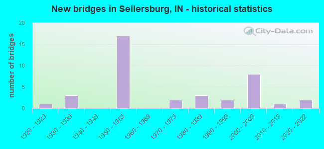
- New bridges - historical statistics
- 11920-1929
- 31930-1939
- 171950-1959
- 21970-1979
- 31980-1989
- 21990-1999
- 82000-2009
- 12010-2019
- 22020-2022
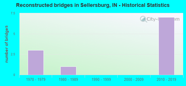
- Reconstructed bridges - Historical Statistics
- 31970-1979
- 11980-1989
- 01990-1999
- 02000-2009
- 72010-2019
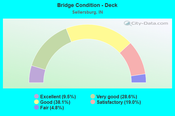
- Bridge Condition - Deck
- 9.5%Excellent
- 28.6%Very good
- 38.1%Good
- 19.0%Satisfactory
- 4.8%Fair

- Bridge Condition - Superstructure
- 9.5%Excellent
- 42.9%Very good
- 14.3%Good
- 23.8%Satisfactory
- 9.5%Fair
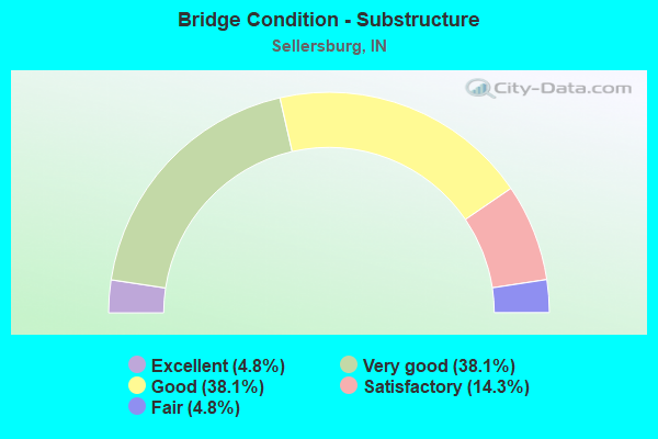
- Bridge Condition - Substructure
- 4.8%Excellent
- 38.1%Very good
- 38.1%Good
- 14.3%Satisfactory
- 4.8%Fair
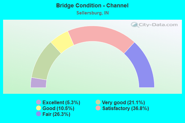
- Bridge Condition - Channel
- 5.3%Excellent
- 21.1%Very good
- 10.5%Good
- 36.8%Satisfactory
- 26.3%Fair
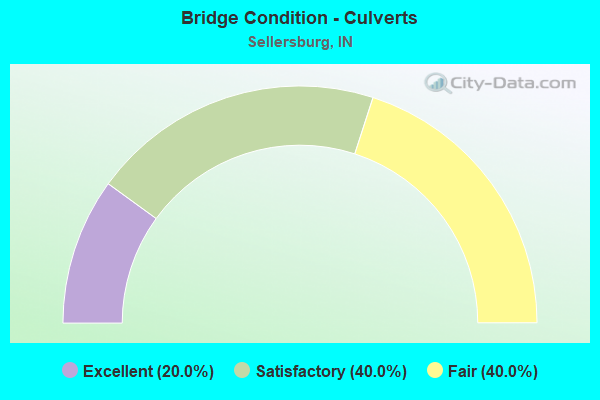
- Bridge Condition - Culverts
- 20.0%Excellent
- 40.0%Satisfactory
- 40.0%Fair
Find on map >> Show street view
Structure Number: 9, Location: 01.65 N SR 101 (Lat: 39.448431, Lng: -85.030461), Route carried "on" structure: State highway 1, Year Built: 1931, Status: Open, Structure Length: 0.94m (3.08ft), Average Daily Traffic: 3,563 (year 2014), Truck Traffic: 10%, Average Future Daily Traffic: 5,831 (year 2033), Design Load: H 20, Features Intersected: BUTLERS RUN
Minimum Vertical Clearance: 30+ m (98+ ft), Kilometerpoint: 18.749, Lanes on structure: 2, Owner: State Highway Agency, Approaching Roadway Width: 7.9m (25.9ft), Skew: 4 degrees, Material/Design: Concrete, Design/Construction: Culvert, Number Of Spans In Main Unit: 1, Length of Maximum Span: 8.5m (27.9ft), Curb-To-Curb Width: 11.0m (36.1ft), Out-to-Out Width: 11.0m (36.1ft)
Condition: Channel: Satisfactory, Culverts: Fair, Structural Evaluation: Somewhat better than minimum adequacy, Deck Geometry: Somewhat better than minimum adequacy, Waterway Adequacy: Better than present minimum criteria, Approach Roadway Alignment: Equal to present desirable criteria, Designated Inspection Frequency: Every 24 months, Inspection Date: July 2021
Find on map >> Show street view
Structure Number: 3481, Location: 00.60 S SR 14 (Lat: 41.065319, Lng: -85.742500), Route carried "on" structure: State highway 13, Year Built: 2021, Status: Open, Structure Length: 2.80m (9.19ft), Average Daily Traffic: 2,950 (year 2020), Truck Traffic: 15%, Average Future Daily Traffic: 3,210 (year 2040), Design Load: HL 93, Features Intersected: PLUNGE CREEK
Minimum Vertical Clearance: 30+ m (98+ ft), Kilometerpoint: 2.285, Lanes on structure: 2, Owner: State Highway Agency, Approaching Roadway Width: 11.0m (36.1ft), Skew: 1 degrees, Material/Design: Concrete continuous, Design/Construction: Slab, Number Of Spans In Main Unit: 3, Length of Maximum Span: 11.0m (36.1ft), Curb-To-Curb Width: 11.0m (36.1ft), Out-to-Out Width: 11.9m (39.0ft)
Condition: Deck: Excellent, Superstructure: Excellent, Substructure: Excellent, Channel: Excellent, Operating Rating: 49.6 metric tons, Method Used To Determine Operating Rating: Load and Resistance Factor Rating (LRFR) rating reported by rating factor(RF) method using HL-93 loadings, Inventory Rating: 38.2 metric tons, Method Used To Determine Inventory Rating: Load and Resistance Factor Rating (LRFR) rating reported by rating factor(RF) method using HL-93 loadings, Structural Evaluation: Superior to present desirable criteria, Deck Geometry: Somewhat better than minimum adequacy, Waterway Adequacy: Superior to present desirable criteria, Approach Roadway Alignment: Equal to present desirable criteria, Designated Inspection Frequency: Every 24 months, Inspection Date: June 2021, Deck Structure Type: Concrete Cast-file-Place, Wearing Surface/Protective System: Wearing Surface: Monolithic Concrete, Deck Protection: Epoxy Coated Reinforcing
Find on map >> Show street view
Structure Number: 9, Location: 00.68 N SR 403 (Lat: 38.415869, Lng: -85.752719), Route carried "on" structure: US 31, Year Built: 1932, Year Reconstructed: 1984, Status: Open, Structure Length: 5.52m (18.11ft), Average Daily Traffic: 8,780 (year 2019), Truck Traffic: 5%, Average Future Daily Traffic: 10,850 (year 2039), Design Load: H 20, Features Intersected: MUDDY FORK, CO RD
Minimum Vertical Clearance: 30+ m (98+ ft), Kilometerpoint: 17.268, Lanes on structure: 2, Lanes under structure: 2, Owner: State Highway Agency, Approaching Roadway Width: 10.4m (34.1ft), Skew: 1 degrees, Material/Design: Concrete, Design/Construction: Arch - Deck, Number Of Spans In Main Unit: 3, Length of Maximum Span: 13.7m (44.9ft), Curb-To-Curb Width: 10.2m (33.5ft), Out-to-Out Width: 11.1m (36.4ft)
Condition: Deck: Satisfactory, Superstructure: Satisfactory, Substructure: Good, Channel: Satisfactory, Operating Rating: 81.6 metric tons, Method Used To Determine Operating Rating: Load Factor (LF), Inventory Rating: 49.0 metric tons, Method Used To Determine Inventory Rating: Load Factor (LF), Structural Evaluation: Equal to present minimum criteria, Deck Geometry: Meets minimum limits, Underclear: High priority of corrective action, Waterway Adequacy: Better than present minimum criteria, Approach Roadway Alignment: Equal to present desirable criteria, Designated Inspection Frequency: Every 24 months, Inspection Date: April 2020, Deck Structure Type: Concrete Cast-file-Place, Wearing Surface/Protective System: Wearing Surface: Latex Concrete, Deck Protection: Epoxy Coated Reinforcing
Find on map >> Show street view
Structure Number: 1414, Location: 06.84 W US 27 (Lat: 39.816950, Lng: -85.015711), Route carried "on" structure: US 40, Year Built: 1925, Year Reconstructed: 1982, Status: Open, Structure Length: 4.40m (14.44ft), Average Daily Traffic: 9,609 (year 2004), Truck Traffic: 10%, Average Future Daily Traffic: 15,952 (year 2030), Design Load: H 20, Features Intersected: NOLANDS FORK
Minimum Vertical Clearance: 30+ m (98+ ft), Kilometerpoint: 17.719, Lanes on structure: 4, Owner: State Highway Agency, Approaching Roadway Width: 16.5m (54.1ft), Skew: 2 degrees, Material/Design: Concrete, Design/Construction: Culvert, Number Of Spans In Main Unit: 3, Length of Maximum Span: 14.0m (45.9ft), Curb or Sidewalk Widths: Left: 0.1m (0.3ft), Right: 0.1m (0.3ft), Curb-To-Curb Width: 18.3m (60.0ft), Out-to-Out Width: 19.2m (63.0ft)
Condition: Channel: Fair, Culverts: Fair, Operating Rating: 50.3 metric tons, Method Used To Determine Operating Rating: Field evaluation and documented engineering judgment, Inventory Rating: 30.0 metric tons, Method Used To Determine Inventory Rating: Field evaluation and documented engineering judgment, Structural Evaluation: Somewhat better than minimum adequacy, Deck Geometry: Somewhat better than minimum adequacy, Waterway Adequacy: Superior to present desirable criteria, Approach Roadway Alignment: Equal to present desirable criteria, Designated Inspection Frequency: Every 24 months, Inspection Date: November 2020
Find on map >> Show street view
Structure Number: 2155, Location: 01.97 W SR 311 (Lat: 38.404119, Lng: -85.787469), Route carried "on" structure: State highway 60, Year Built: 1952, Status: Open, Structure Length: 1.01m (3.31ft), Average Daily Traffic: 11,358 (year 2004), Truck Traffic: 10%, Average Future Daily Traffic: 16,648 (year 2031), Design Load: HS 20, Features Intersected: ELK RUN
Minimum Vertical Clearance: 30+ m (98+ ft), Kilometerpoint: 20.889, Lanes on structure: 2, Base Highway Network: Yes (, Subroute: 1), Owner: State Highway Agency, Approaching Roadway Width: 9.1m (29.9ft), Skew: 2 degrees, Material/Design: Concrete, Design/Construction: Culvert, Number Of Spans In Main Unit: 1, Length of Maximum Span: 9.1m (29.9ft), Curb or Sidewalk Widths: Left: 0.1m (0.3ft), Right: 0.1m (0.3ft), Curb-To-Curb Width: 11.9m (39.0ft), Out-to-Out Width: 12.6m (41.3ft)
Condition: Channel: Fair, Culverts: Satisfactory, Operating Rating: 54.5 metric tons, Method Used To Determine Operating Rating: Field evaluation and documented engineering judgment, Inventory Rating: 32.7 metric tons, Method Used To Determine Inventory Rating: Field evaluation and documented engineering judgment, Structural Evaluation: Equal to present minimum criteria, Deck Geometry: Somewhat better than minimum adequacy, Waterway Adequacy: Better than present minimum criteria, Approach Roadway Alignment: Equal to present desirable criteria, Designated Inspection Frequency: Every 24 months, Inspection Date: March 2022
Find on map >> Show street view
Structure Number: 2156, Location: 01.05 E SR 311 (Lat: 38.370300, Lng: -85.755781), Route carried "on" structure: State highway 60, Year Built: 2004, Status: Open, Structure Length: 5.64m (18.50ft), Average Daily Traffic: 10,467 (year 2004), Truck Traffic: 10%, Average Future Daily Traffic: 30,320 (year 2033), Design Load: HS 20+Mod, Features Intersected: I-65
Minimum Vertical Clearance: 30+ m (98+ ft), Kilometerpoint: 25.750, Lanes on structure: 3, Lanes under structure: 6, Base Highway Network: Yes (, Subroute: 1), Owner: State Highway Agency, Approaching Roadway Width: 14.3m (46.9ft), Skew: 1 degrees, Material/Design: Steel continuous, Design/Construction: Stringer/Multi-beam, Number Of Spans In Main Unit: 2, Length of Maximum Span: 28.0m (91.9ft), Curb-To-Curb Width: 14.6m (47.9ft), Out-to-Out Width: 15.6m (51.2ft)
Condition: Deck: Very good, Superstructure: Very good, Substructure: Very good, Operating Rating: 83.0 metric tons, Method Used To Determine Operating Rating: Load Factor (LF), Inventory Rating: 49.7 metric tons, Method Used To Determine Inventory Rating: Load Factor (LF), Structural Evaluation: Equal to present desirable criteria, Deck Geometry: Somewhat better than minimum adequacy, Underclear: Equal to present minimum criteria, Approach Roadway Alignment: Equal to present desirable criteria, Designated Inspection Frequency: Every 24 months, Inspection Date: March 2022, Deck Structure Type: Concrete Cast-file-Place, Wearing Surface/Protective System: Wearing Surface: Monolithic Concrete, Deck Protection: Epoxy Coated Reinforcing
Find on map >> Show street view
Structure Number: 21561, Location: 01.05 E of SR 311 (Lat: 38.370450, Lng: -85.755831), Route carried "on" structure: State highway 60, Year Built: 2004, Status: Open, Structure Length: 5.64m (18.50ft), Average Daily Traffic: 10,467 (year 2004), Truck Traffic: 10%, Average Future Daily Traffic: 14,751 (year 2033), Design Load: HS 20+Mod, Features Intersected: I-65
Minimum Vertical Clearance: 30+ m (98+ ft), Kilometerpoint: 25.750, Lanes on structure: 3, Lanes under structure: 6, Base Highway Network: Yes (, Subroute: 1), Owner: State Highway Agency, Approaching Roadway Width: 14.3m (46.9ft), Skew: 1 degrees, Material/Design: Steel continuous, Design/Construction: Stringer/Multi-beam, Number Of Spans In Main Unit: 2, Length of Maximum Span: 28.0m (91.9ft), Curb-To-Curb Width: 14.6m (47.9ft), Out-to-Out Width: 15.6m (51.2ft)
Condition: Deck: Good, Superstructure: Very good, Substructure: Very good, Operating Rating: 82.8 metric tons, Method Used To Determine Operating Rating: Load Factor (LF), Inventory Rating: 49.6 metric tons, Method Used To Determine Inventory Rating: Load Factor (LF), Structural Evaluation: Equal to present desirable criteria, Deck Geometry: Somewhat better than minimum adequacy, Underclear: Equal to present minimum criteria, Approach Roadway Alignment: Equal to present desirable criteria, Designated Inspection Frequency: Every 24 months, Inspection Date: March 2022, Deck Structure Type: Concrete Cast-file-Place, Wearing Surface/Protective System: Wearing Surface: Monolithic Concrete, Deck Protection: Epoxy Coated Reinforcing
Find on map >> Show street view
Structure Number: 3474, Location: 01.74 N SR 60 (Lat: 38.394131, Lng: -85.762439), Route carried "on" structure: Interstate 65, Year Built: 1958, Year Reconstructed: 2017, Status: Open, Structure Length: 6.02m (19.75ft), Average Daily Traffic: 27,144 (year 2015), Truck Traffic: 30%, Average Future Daily Traffic: 34,742 (year 2035), Design Load: HL 93, Features Intersected: SR 311X
Minimum Vertical Clearance: 30+ m (98+ ft), Kilometerpoint: 14.645, Lanes on structure: 4, Lanes under structure: 4, Base Highway Network: Yes (, Subroute: 1), Owner: State Highway Agency, Approaching Roadway Width: 21.2m (69.6ft), Skew: 2 degrees, Material/Design: Prestressed concrete continuous, Design/Construction: Box Beam or Girders - Single/Spread, Number Of Spans In Main Unit: 4, Length of Maximum Span: 16.7m (54.8ft), Curb-To-Curb Width: 20.5m (67.3ft), Out-to-Out Width: 21.4m (70.2ft)
Condition: Deck: Very good, Superstructure: Very good, Substructure: Very good, Operating Rating: 52.8 metric tons, Method Used To Determine Operating Rating: Load and Resistance Factor Rating (LRFR) rating reported by rating factor(RF) method using HL-93 loadings, Inventory Rating: 35.6 metric tons, Method Used To Determine Inventory Rating: Load and Resistance Factor Rating (LRFR) rating reported by rating factor(RF) method using HL-93 loadings, Structural Evaluation: Equal to present desirable criteria, Deck Geometry: Equal to present minimum criteria, Underclear: High priority of corrective action, Approach Roadway Alignment: Equal to present desirable criteria, Designated Inspection Frequency: Every 24 months, Inspection Date: August 2021, Deck Structure Type: Concrete Cast-file-Place, Wearing Surface/Protective System: Wearing Surface: Monolithic Concrete, Deck Protection: Epoxy Coated Reinforcing
Find on map >> Show street view
Structure Number: 3475, Location: 01.74 N SR 60 (Lat: 38.393911, Lng: -85.762739), Route carried "on" structure: Interstate 65, Year Built: 1958, Year Reconstructed: 2017, Status: Open, Structure Length: 6.02m (19.75ft), Average Daily Traffic: 29,406 (year 2015), Truck Traffic: 30%, Average Future Daily Traffic: 37,638 (year 2035), Design Load: HL 93, Features Intersected: SR 311X
Minimum Vertical Clearance: 30+ m (98+ ft), Kilometerpoint: 14.645, Lanes on structure: 4, Lanes under structure: 4, Base Highway Network: Yes (, Subroute: 1), Owner: State Highway Agency, Approaching Roadway Width: 21.2m (69.6ft), Skew: 2 degrees, Material/Design: Prestressed concrete continuous, Design/Construction: Box Beam or Girders - Single/Spread, Number Of Spans In Main Unit: 4, Length of Maximum Span: 16.7m (54.8ft), Curb-To-Curb Width: 20.5m (67.3ft), Out-to-Out Width: 21.4m (70.2ft)
Condition: Deck: Very good, Superstructure: Very good, Substructure: Very good, Operating Rating: 53.1 metric tons, Method Used To Determine Operating Rating: Load and Resistance Factor Rating (LRFR) rating reported by rating factor(RF) method using HL-93 loadings, Inventory Rating: 36.0 metric tons, Method Used To Determine Inventory Rating: Load and Resistance Factor Rating (LRFR) rating reported by rating factor(RF) method using HL-93 loadings, Structural Evaluation: Equal to present desirable criteria, Deck Geometry: Equal to present minimum criteria, Underclear: High priority of corrective action, Approach Roadway Alignment: Equal to present desirable criteria, Designated Inspection Frequency: Every 24 months, Inspection Date: August 2021, Deck Structure Type: Concrete Cast-file-Place, Wearing Surface/Protective System: Wearing Surface: Monolithic Concrete, Deck Protection: Epoxy Coated Reinforcing
Find on map >> Show street view
Structure Number: 3476, Location: 01.12 N SR 311 (Lat: 38.409881, Lng: -85.765011), Route carried "on" structure: Alternate County highway , Year Built: 1958, Year Reconstructed: 1985, Status: Open, Structure Length: 7.01m (23.00ft), Average Daily Traffic: 2,399 (year 2004), Truck Traffic: 10%, Average Future Daily Traffic: 4,006 (year 2030), Design Load: HS 20, Features Intersected: I-65, Facility Carried by Structure: ST JOE ROAD
Minimum Vertical Clearance: 30+ m (98+ ft), Kilometerpoint: 0.000, Lanes on structure: 2, Lanes under structure: 6, Owner: State Highway Agency, Approaching Roadway Width: 7.3m (24.0ft), Skew: 2 degrees, Material/Design: Concrete continuous, Design/Construction: Stringer/Multi-beam, Number Of Spans In Main Unit: 4, Length of Maximum Span: 21.4m (70.2ft), Curb or Sidewalk Widths: Left: 0.5m (1.6ft), Right: 0.5m (1.6ft), Curb-To-Curb Width: 7.3m (24.0ft), Out-to-Out Width: 9.1m (29.9ft)
Condition: Deck: Good, Superstructure: Fair, Substructure: Satisfactory, Operating Rating: 64.8 metric tons, Method Used To Determine Operating Rating: Load Factor (LF), Inventory Rating: 38.8 metric tons, Method Used To Determine Inventory Rating: Load Factor (LF), Structural Evaluation: Somewhat better than minimum adequacy, Deck Geometry: High priority of replacement, Underclear: Meets minimum limits, Approach Roadway Alignment: Equal to present minimum criteria, Designated Inspection Frequency: Every 24 months, Inspection Date: August 2021, Deck Structure Type: Concrete Cast-file-Place, Wearing Surface/Protective System: Wearing Surface: Latex Concrete
Find on map >> Show street view
Structure Number: 3478, Location: 02.38 N SR 311 (Lat: 38.428281, Lng: -85.764811), Route carried "on" structure: Interstate 65, Year Built: 1958, Year Reconstructed: 2017, Status: Open, Structure Length: 5.34m (17.52ft), Average Daily Traffic: 18,874 (year 2015), Truck Traffic: 30%, Average Future Daily Traffic: 22,190 (year 2035), Design Load: HL 93, Features Intersected: MUDDY FORK
Minimum Vertical Clearance: 30+ m (98+ ft), Kilometerpoint: 18.475, Lanes on structure: 3, Base Highway Network: Yes (, Subroute: 1), Owner: State Highway Agency, Approaching Roadway Width: 19.5m (64.0ft), Skew: 1 degrees, Material/Design: Prestressed concrete continuous, Design/Construction: Box Beam or Girders - Single/Spread, Number Of Spans In Main Unit: 3, Length of Maximum Span: 19.2m (63.0ft), Curb-To-Curb Width: 19.0m (62.3ft), Out-to-Out Width: 19.8m (65.0ft)
Condition: Deck: Very good, Superstructure: Very good, Substructure: Very good, Channel: Very good, Operating Rating: 56.1 metric tons, Method Used To Determine Operating Rating: Load and Resistance Factor Rating (LRFR) rating reported by rating factor(RF) method using HL-93 loadings, Inventory Rating: 29.5 metric tons, Method Used To Determine Inventory Rating: Load and Resistance Factor Rating (LRFR) rating reported by rating factor(RF) method using HL-93 loadings, Structural Evaluation: Better than present minimum criteria, Deck Geometry: Superior to present desirable criteria, Waterway Adequacy: Better than present minimum criteria, Approach Roadway Alignment: Equal to present desirable criteria, Designated Inspection Frequency: Every 24 months, Inspection Date: August 2021, Deck Structure Type: Concrete Cast-file-Place, Wearing Surface/Protective System: Wearing Surface: Monolithic Concrete, Deck Protection: Epoxy Coated Reinforcing
Find on map >> Show street view
Structure Number: 3479, Location: 02.38 N SR 311 (Lat: 38.428181, Lng: -85.765111), Route carried "on" structure: Interstate 65, Year Built: 1958, Year Reconstructed: 2017, Status: Open, Structure Length: 5.34m (17.52ft), Average Daily Traffic: 20,446 (year 2015), Truck Traffic: 30%, Average Future Daily Traffic: 24,040 (year 2035), Design Load: HL 93, Features Intersected: MUDDY FORK
Minimum Vertical Clearance: 30+ m (98+ ft), Kilometerpoint: 18.475, Lanes on structure: 3, Base Highway Network: Yes (, Subroute: 1), Owner: State Highway Agency, Approaching Roadway Width: 19.5m (64.0ft), Skew: 1 degrees, Material/Design: Prestressed concrete continuous, Design/Construction: Box Beam or Girders - Single/Spread, Number Of Spans In Main Unit: 3, Length of Maximum Span: 19.2m (63.0ft), Curb-To-Curb Width: 19.0m (62.3ft), Out-to-Out Width: 19.8m (65.0ft)
Condition: Deck: Very good, Superstructure: Very good, Substructure: Very good, Channel: Very good, Operating Rating: 56.1 metric tons, Method Used To Determine Operating Rating: Load and Resistance Factor Rating (LRFR) rating reported by rating factor(RF) method using HL-93 loadings, Inventory Rating: 29.5 metric tons, Method Used To Determine Inventory Rating: Load and Resistance Factor Rating (LRFR) rating reported by rating factor(RF) method using HL-93 loadings, Structural Evaluation: Better than present minimum criteria, Deck Geometry: Superior to present desirable criteria, Waterway Adequacy: Better than present minimum criteria, Approach Roadway Alignment: Equal to present desirable criteria, Designated Inspection Frequency: Every 24 months, Inspection Date: August 2021, Deck Structure Type: Concrete Cast-file-Place, Wearing Surface/Protective System: Wearing Surface: Monolithic Concrete, Deck Protection: Epoxy Coated Reinforcing
Find on map >> Show street view
Structure Number: 348, Location: 03.31 N SR 311 (Lat: 38.441600, Lng: -85.766131), Route carried "on" structure: Interstate 65, Year Built: 1958, Year Reconstructed: 2017, Status: Open, Structure Length: 3.94m (12.93ft), Average Daily Traffic: 20,446 (year 2015), Truck Traffic: 30%, Average Future Daily Traffic: 24,040 (year 2035), Design Load: HL 93, Features Intersected: PERRY CROSSING ROAD
Minimum Vertical Clearance: 30+ m (98+ ft), Kilometerpoint: 19.972, Lanes on structure: 3, Lanes under structure: 2, Base Highway Network: Yes (, Subroute: 1), Owner: State Highway Agency, Approaching Roadway Width: 17.1m (56.1ft), Skew: 2 degrees, Material/Design: Prestressed concrete continuous, Design/Construction: Box Beam or Girders - Single/Spread, Number Of Spans In Main Unit: 3, Length of Maximum Span: 12.8m (42.0ft), Curb-To-Curb Width: 16.9m (55.4ft), Out-to-Out Width: 17.8m (58.4ft)
Condition: Deck: Excellent, Superstructure: Excellent, Substructure: Good, Operating Rating: 57.0 metric tons, Method Used To Determine Operating Rating: Load and Resistance Factor Rating (LRFR) rating reported by rating factor(RF) method using HL-93 loadings, Inventory Rating: 28.8 metric tons, Method Used To Determine Inventory Rating: Load and Resistance Factor Rating (LRFR) rating reported by rating factor(RF) method using HL-93 loadings, Structural Evaluation: Better than present minimum criteria, Deck Geometry: Equal to present minimum criteria, Underclear: Meets minimum limits, Approach Roadway Alignment: Equal to present desirable criteria, Designated Inspection Frequency: Every 24 months, Inspection Date: August 2021, Deck Structure Type: Concrete Cast-file-Place, Wearing Surface/Protective System: Wearing Surface: Monolithic Concrete, Deck Protection: Epoxy Coated Reinforcing
Find on map >> Show street view
Structure Number: 3481, Location: 03.31 N SR 311 (Lat: 38.441439, Lng: -85.766389), Route carried "on" structure: Interstate 65, Year Built: 1958, Year Reconstructed: 2017, Status: Open, Structure Length: 3.94m (12.93ft), Average Daily Traffic: 18,874 (year 2015), Truck Traffic: 30%, Average Future Daily Traffic: 22,190 (year 2035), Design Load: HS 20, Features Intersected: PERRY CROSSING ROAD
Minimum Vertical Clearance: 30+ m (98+ ft), Kilometerpoint: 19.972, Lanes on structure: 3, Lanes under structure: 2, Base Highway Network: Yes (, Subroute: 1), Owner: State Highway Agency, Approaching Roadway Width: 17.1m (56.1ft), Skew: 2 degrees, Material/Design: Prestressed concrete continuous, Design/Construction: Box Beam or Girders - Single/Spread, Number Of Spans In Main Unit: 3, Length of Maximum Span: 12.8m (42.0ft), Curb-To-Curb Width: 16.9m (55.4ft), Out-to-Out Width: 17.8m (58.4ft)
Condition: Deck: Good, Superstructure: Very good, Substructure: Good, Operating Rating: 58.6 metric tons, Method Used To Determine Operating Rating: Load and Resistance Factor Rating (LRFR) rating reported by rating factor(RF) method using HL-93 loadings, Inventory Rating: 37.6 metric tons, Method Used To Determine Inventory Rating: Load and Resistance Factor Rating (LRFR) rating reported by rating factor(RF) method using HL-93 loadings, Structural Evaluation: Better than present minimum criteria, Deck Geometry: Equal to present minimum criteria, Underclear: Meets minimum limits, Approach Roadway Alignment: Equal to present desirable criteria, Designated Inspection Frequency: Every 24 months, Inspection Date: August 2021, Deck Structure Type: Concrete Cast-file-Place, Wearing Surface/Protective System: Wearing Surface: Monolithic Concrete, Deck Protection: Epoxy Coated Reinforcing
Find on map >> Show street view
Structure Number: 1000012, Location: 00.20 W COLUMBUS-MANN RD (Lat: 38.438239, Lng: -85.773514), Route carried "on" structure: Alternate County highway , Year Built: 1977, Year Reconstructed: 2010, Status: Open, Structure Length: 4.17m (13.68ft), Average Daily Traffic: 420 (year 2018), Truck Traffic: 5%, Average Future Daily Traffic: 730 (year 2038), Design Load: HS 20, Features Intersected: MUDDY FORK CREEK, Facility Carried by Structure: PERRY CROSSING RD
Minimum Vertical Clearance: 30+ m (98+ ft), Kilometerpoint: 0.000, Lanes on structure: 2, Owner: County Highway Agency, Approaching Roadway Width: 10.7m (35.1ft), Material/Design: Prestressed concrete continuous, Design/Construction: Box Beam or Girders - Single/Spread, Number Of Spans In Main Unit: 3, Length of Maximum Span: 14.4m (47.2ft), Curb-To-Curb Width: 11.3m (37.1ft), Out-to-Out Width: 11.9m (39.0ft)
Condition: Deck: Good, Superstructure: Satisfactory, Substructure: Good, Channel: Good, Operating Rating: 32.7 metric tons, Method Used To Determine Operating Rating: Field evaluation and documented engineering judgment, Inventory Rating: 32.7 metric tons, Method Used To Determine Inventory Rating: Field evaluation and documented engineering judgment, Structural Evaluation: Equal to present minimum criteria, Deck Geometry: Better than present minimum criteria, Waterway Adequacy: Equal to present desirable criteria, Approach Roadway Alignment: Equal to present desirable criteria, Designated Inspection Frequency: Every 24 months, Inspection Date: March 2020, Deck Structure Type: Concrete Cast-file-Place, Wearing Surface/Protective System: Wearing Surface: Monolithic Concrete
Find on map >> Show street view
Structure Number: 1000013, Location: 00.00 N of Weber Road (Lat: 38.436411, Lng: -85.748703), Route carried "on" structure: Alternate County highway , Year Built: 1994, Status: Open, Structure Length: 4.83m (15.85ft), Average Daily Traffic: 410 (year 2018), Truck Traffic: 3%, Average Future Daily Traffic: 710 (year 2038), Design Load: HS 20, Features Intersected: SILVER Creek, Facility Carried by Structure: BUD PRATHER ROAD
Minimum Vertical Clearance: 30+ m (98+ ft), Kilometerpoint: 0.000, Lanes on structure: 2, Owner: County Highway Agency, Approaching Roadway Width: 6.7m (22.0ft), Skew: 1 degrees, Material/Design: Concrete continuous, Design/Construction: Slab, Number Of Spans In Main Unit: 3, Length of Maximum Span: 17.5m (57.4ft), Curb-To-Curb Width: 7.4m (24.3ft), Out-to-Out Width: 8.3m (27.2ft)
Condition: Deck: Satisfactory, Superstructure: Satisfactory, Substructure: Good, Channel: Satisfactory, Operating Rating: 45.9 metric tons, Method Used To Determine Operating Rating: Load and Resistance Factor (LRFR), Inventory Rating: 34.1 metric tons, Method Used To Determine Inventory Rating: Load and Resistance Factor (LRFR), Structural Evaluation: Equal to present minimum criteria, Deck Geometry: Meets minimum limits, Waterway Adequacy: Better than present minimum criteria, Approach Roadway Alignment: Equal to present minimum criteria, Designated Inspection Frequency: Every 24 months, Inspection Date: March 2020, Deck Structure Type: Concrete Cast-file-Place, Wearing Surface/Protective System: Wearing Surface: Monolithic Concrete, Deck Protection: Epoxy Coated Reinforcing
Find on map >> Show street view
Structure Number: 1000014, Location: 00.60 S of Sterling Oaks (Lat: 38.412300, Lng: -85.772583), Route carried "on" structure: Alternate County highway , Year Built: 2002, Status: Open, Structure Length: 2.45m (8.04ft), Average Daily Traffic: 410 (year 2018), Truck Traffic: 5%, Average Future Daily Traffic: 710 (year 2038), Design Load: HS 20, Features Intersected: ELK RUN, Facility Carried by Structure: ALLENTOWN ROAD
Minimum Vertical Clearance: 30+ m (98+ ft), Kilometerpoint: 0.000, Lanes on structure: 2, Owner: County Highway Agency, Approaching Roadway Width: 6.7m (22.0ft), Skew: 3 degrees, Material/Design: Concrete continuous, Design/Construction: Slab, Number Of Spans In Main Unit: 3, Length of Maximum Span: 9.4m (30.8ft), Curb-To-Curb Width: 8.6m (28.2ft), Out-to-Out Width: 8.7m (28.5ft)
Condition: Deck: Good, Superstructure: Good, Substructure: Good, Channel: Good, Operating Rating: 55.3 metric tons, Method Used To Determine Operating Rating: Load and Resistance Factor (LRFR), Inventory Rating: 41.1 metric tons, Method Used To Determine Inventory Rating: Load and Resistance Factor (LRFR), Structural Evaluation: Better than present minimum criteria, Deck Geometry: Somewhat better than minimum adequacy, Waterway Adequacy: Better than present minimum criteria, Approach Roadway Alignment: Equal to present desirable criteria, Designated Inspection Frequency: Every 24 months, Inspection Date: March 2020, Deck Structure Type: Concrete Cast-file-Place, Wearing Surface/Protective System: Wearing Surface: Monolithic Concrete, Deck Protection: Epoxy Coated Reinforcing
Find on map >> Show street view
Structure Number: 1000069, Location: 00.10 E of Bennetsville R (Lat: 38.450500, Lng: -85.815292), Route carried "on" structure: Alternate County highway , Year Built: 1976, Status: Open, Structure Length: 2.51m (8.23ft), Average Daily Traffic: 420 (year 2018), Truck Traffic: 5%, Average Future Daily Traffic: 730 (year 2038), Features Intersected: MUDDY FORK, Facility Carried by Structure: EBENEZER CH ROAD
Minimum Vertical Clearance: 30+ m (98+ ft), Kilometerpoint: 0.000, Lanes on structure: 2, Owner: County Highway Agency, Approaching Roadway Width: 6.1m (20.0ft), Skew: 3 degrees, Material/Design: Prestressed concrete, Design/Construction: Stringer/Multi-beam, Number Of Spans In Main Unit: 1, Length of Maximum Span: 23.8m (78.1ft), Curb-To-Curb Width: 7.4m (24.3ft), Out-to-Out Width: 8.0m (26.2ft)
Condition: Deck: Satisfactory, Superstructure: Satisfactory, Substructure: Satisfactory, Channel: Fair, Operating Rating: 67.9 metric tons, Method Used To Determine Operating Rating: Load and Resistance Factor (LRFR), Inventory Rating: 55.3 metric tons, Method Used To Determine Inventory Rating: Load and Resistance Factor (LRFR), Structural Evaluation: Equal to present minimum criteria, Deck Geometry: Meets minimum limits, Waterway Adequacy: Equal to present desirable criteria, Approach Roadway Alignment: Equal to present minimum criteria, Designated Inspection Frequency: Every 24 months, Inspection Date: March 2020, Deck Structure Type: Concrete Cast-file-Place, Wearing Surface/Protective System: Wearing Surface: Monolithic Concrete
Find on map >> Show street view
Structure Number: 100007, Location: 00.40 N SR 60 (Lat: 38.450869, Lng: -85.827606), Route carried "on" structure: Alternate County highway , Year Built: 1986, Status: Open, Structure Length: 0.66m (2.17ft), Average Daily Traffic: 420 (year 2018), Truck Traffic: 3%, Average Future Daily Traffic: 730 (year 2038), Features Intersected: BRANCH OF MUDDY FORK, Facility Carried by Structure: WILSON SWITCH RD
Minimum Vertical Clearance: 30+ m (98+ ft), Kilometerpoint: 0.000, Lanes on structure: 2, Owner: County Highway Agency, Approaching Roadway Width: 6.1m (20.0ft), Material/Design: Steel, Design/Construction: Culvert, Number Of Spans In Main Unit: 3, Length of Maximum Span: 2.1m (6.9ft), Curb-To-Curb Width: 6.4m (21.0ft), Out-to-Out Width: 6.4m (21.0ft)
Condition: Channel: Fair, Culverts: Satisfactory, Operating Rating: 32.7 metric tons, Method Used To Determine Operating Rating: Field evaluation and documented engineering judgment, Inventory Rating: 32.7 metric tons, Method Used To Determine Inventory Rating: Field evaluation and documented engineering judgment, Structural Evaluation: Equal to present minimum criteria, Deck Geometry: High priority of corrective action, Waterway Adequacy: Somewhat better than minimum adequacy, Approach Roadway Alignment: Equal to present desirable criteria, Designated Inspection Frequency: Every 24 months, Inspection Date: March 2020, Wearing Surface/Protective System: Wearing Surface: Bituminous
Find on map >> Show street view
Structure Number: 1000071, Location: 00.10 N SR 60 (Lat: 38.447061, Lng: -85.827728), Route carried "on" structure: Alternate County highway , Year Built: 1991, Status: Open, Structure Length: 2.56m (8.40ft), Average Daily Traffic: 420 (year 2018), Truck Traffic: 3%, Average Future Daily Traffic: 730 (year 2038), Features Intersected: MUDDY FORK, Facility Carried by Structure: WILSON SWITCH RD
Minimum Vertical Clearance: 30+ m (98+ ft), Kilometerpoint: 0.000, Lanes on structure: 2, Owner: County Highway Agency, Approaching Roadway Width: 7.0m (23.0ft), Skew: 1 degrees, Material/Design: Concrete continuous, Design/Construction: Slab, Number Of Spans In Main Unit: 3, Length of Maximum Span: 10.1m (33.1ft), Curb-To-Curb Width: 8.5m (27.9ft), Out-to-Out Width: 9.4m (30.8ft)
Condition: Deck: Satisfactory, Superstructure: Satisfactory, Substructure: Satisfactory, Channel: Satisfactory, Operating Rating: 32.7 metric tons, Method Used To Determine Operating Rating: Field evaluation and documented engineering judgment, Inventory Rating: 32.7 metric tons, Method Used To Determine Inventory Rating: Field evaluation and documented engineering judgment, Structural Evaluation: Equal to present minimum criteria, Deck Geometry: Somewhat better than minimum adequacy, Waterway Adequacy: Better than present minimum criteria, Approach Roadway Alignment: Equal to present desirable criteria, Designated Inspection Frequency: Every 24 months, Inspection Date: March 2020, Deck Structure Type: Concrete Cast-file-Place, Wearing Surface/Protective System: Wearing Surface: Monolithic Concrete, Deck Protection: Epoxy Coated Reinforcing
Find on map >> Show street view
Structure Number: 1000076, Location: 00.40 E of Atkins Road (Lat: 38.407811, Lng: -85.837547), Route carried "on" structure: County highway , Year Built: 2004, Status: Open, Structure Length: 0.82m (2.69ft), Average Daily Traffic: 790 (year 2018), Truck Traffic: 6%, Average Future Daily Traffic: 1,370 (year 2038), Features Intersected: INDIAN CREEK, Facility Carried by Structure: ST JOHNS ROAD
Minimum Vertical Clearance: 30+ m (98+ ft), Kilometerpoint: 0.000, Lanes on structure: 2, Owner: County Highway Agency, Approaching Roadway Width: 6.1m (20.0ft), Material/Design: Steel, Design/Construction: Stringer/Multi-beam, Number Of Spans In Main Unit: 1, Length of Maximum Span: 7.2m (23.6ft), Curb-To-Curb Width: 8.6m (28.2ft), Out-to-Out Width: 9.1m (29.9ft)
Condition: Deck: Good, Superstructure: Good, Substructure: Good, Channel: Satisfactory, Operating Rating: 63.0 metric tons, Method Used To Determine Operating Rating: Load and Resistance Factor (LRFR), Inventory Rating: 46.8 metric tons, Method Used To Determine Inventory Rating: Load and Resistance Factor (LRFR), Structural Evaluation: Better than present minimum criteria, Deck Geometry: Somewhat better than minimum adequacy, Waterway Adequacy: Equal to present minimum criteria, Approach Roadway Alignment: Equal to present desirable criteria, Designated Inspection Frequency: Every 24 months, Inspection Date: March 2020, Deck Structure Type: Concrete Cast-file-Place, Wearing Surface/Protective System: Wearing Surface: Monolithic Concrete, Deck Protection: Epoxy Coated Reinforcing
Find on map >> Show street view
Structure Number: 1000081, Location: 00.20 N SR 60 (Lat: 38.447350, Lng: -85.865386), Route carried "on" structure: Alternate County highway , Year Built: 1984, Status: Open, Structure Length: 4.11m (13.48ft), Average Daily Traffic: 420 (year 2018), Truck Traffic: 4%, Average Future Daily Traffic: 730 (year 2038), Features Intersected: MUDDY FORK, Facility Carried by Structure: CARWOOD ROAD
Minimum Vertical Clearance: 30+ m (98+ ft), Kilometerpoint: 0.000, Lanes on structure: 2, Owner: County Highway Agency, Approaching Roadway Width: 6.7m (22.0ft), Skew: 1 degrees, Material/Design: Steel continuous, Design/Construction: Stringer/Multi-beam, Number Of Spans In Main Unit: 3, Length of Maximum Span: 15.5m (50.9ft), Curb-To-Curb Width: 8.5m (27.9ft), Out-to-Out Width: 9.3m (30.5ft)
Condition: Deck: Good, Superstructure: Very good, Substructure: Very good, Channel: Satisfactory, Operating Rating: 52.0 metric tons, Method Used To Determine Operating Rating: Load Factor (LF), Inventory Rating: 31.1 metric tons, Method Used To Determine Inventory Rating: Load Factor (LF), Structural Evaluation: Better than present minimum criteria, Deck Geometry: Somewhat better than minimum adequacy, Waterway Adequacy: Better than present minimum criteria, Approach Roadway Alignment: Equal to present desirable criteria, Designated Inspection Frequency: Every 24 months, Inspection Date: March 2020, Deck Structure Type: Concrete Cast-file-Place, Wearing Surface/Protective System: Wearing Surface: Monolithic Concrete, Deck Protection: Epoxy Coated Reinforcing
Find on map >> Show street view
Structure Number: 1000105, Location: 00.10 SW of U.S. 31 (Lat: 38.393831, Lng: -85.758828), Route carried "on" structure: Alternate City street , Year Built: 1957, Year Reconstructed: 1975, Status: Open, Structure Length: 0.78m (2.56ft), Average Daily Traffic: 210 (year 2018), Truck Traffic: 3%, Average Future Daily Traffic: 370 (year 2038), Features Intersected: CAMP RUN, Facility Carried by Structure: NEW ALBANY STREET
Minimum Vertical Clearance: 30+ m (98+ ft), Kilometerpoint: 0.000, Lanes on structure: 2, Owner: County Highway Agency, Approaching Roadway Width: 5.5m (18.0ft), Material/Design: Steel, Design/Construction: Stringer/Multi-beam, Number Of Spans In Main Unit: 1, Length of Maximum Span: 6.9m (22.6ft), Curb-To-Curb Width: 6.6m (21.7ft), Out-to-Out Width: 7.0m (23.0ft)
Condition: Deck: Fair, Superstructure: Fair, Substructure: Fair, Channel: Satisfactory, Operating Rating: 83.8 metric tons, Method Used To Determine Operating Rating: Load Factor (LF), Inventory Rating: 50.2 metric tons, Method Used To Determine Inventory Rating: Load Factor (LF), Structural Evaluation: Somewhat better than minimum adequacy, Deck Geometry: Meets minimum limits, Waterway Adequacy: Somewhat better than minimum adequacy, Approach Roadway Alignment: Equal to present desirable criteria, Length Of Structure Improvement: 0.91m (2.99ft), Designated Inspection Frequency: Every 24 months, Inspection Date: March 2020, Bridge Improvement Cost: $233,000, Roadway Improvement Cost: $220,000, Total Project Cost: $572,000 ( Estimate for 2020), Deck Structure Type: Concrete Cast-file-Place, Wearing Surface/Protective System: Wearing Surface: Bituminous
Find on map >> Show street view
Structure Number: 1000107, Location: 00.10 W of U.S. 31 (Lat: 38.391700, Lng: -85.756858), Route carried "on" structure: Alternate City street , Year Built: 1985, Status: Open, Structure Length: 0.72m (2.36ft), Average Daily Traffic: 1,020 (year 2018), Truck Traffic: 3%, Average Future Daily Traffic: 1,770 (year 2038), Features Intersected: CAMP Run, Facility Carried by Structure: POPP Ave
Minimum Vertical Clearance: 30+ m (98+ ft), Kilometerpoint: 0.000, Lanes on structure: 2, Owner: County Highway Agency, Approaching Roadway Width: 7.9m (25.9ft), Material/Design: Concrete, Design/Construction: Frame, Number Of Spans In Main Unit: 2, Length of Maximum Span: 3.0m (9.8ft), Curb-To-Curb Width: 8.8m (28.9ft), Out-to-Out Width: 9.4m (30.8ft)
Condition: Deck: Good, Superstructure: Good, Substructure: Good, Channel: Fair, Operating Rating: 32.7 metric tons, Method Used To Determine Operating Rating: Field evaluation and documented engineering judgment, Inventory Rating: 32.7 metric tons, Method Used To Determine Inventory Rating: Field evaluation and documented engineering judgment, Structural Evaluation: Better than present minimum criteria, Deck Geometry: Somewhat better than minimum adequacy, Waterway Adequacy: Somewhat better than minimum adequacy, Approach Roadway Alignment: Equal to present desirable criteria, Designated Inspection Frequency: Every 24 months, Inspection Date: March 2020, Deck Structure Type: Concrete Precast Panels, Wearing Surface/Protective System: Wearing Surface: Bituminous
Find on map >> Show street view
Structure Number: 1000151, Location: 00.10 E RR (Lat: 38.384339, Lng: -85.740450), Route carried "on" structure: Alternate County highway , Year Built: 2015, Status: Open, Structure Length: 1.46m (4.79ft), Average Daily Traffic: 800 (year 2018), Truck Traffic: 6%, Average Future Daily Traffic: 1,390 (year 2038), Design Load: HS 25 or greater, Features Intersected: CAMP RUN, Facility Carried by Structure: BEAN ROAD
Minimum Vertical Clearance: 30+ m (98+ ft), Kilometerpoint: 0.000, Lanes on structure: 2, Owner: County Highway Agency, Approaching Roadway Width: 7.9m (25.9ft), Skew: 4 degrees, Material/Design: Prestressed concrete, Design/Construction: Box Beam or Girders - Single/Spread, Number Of Spans In Main Unit: 1, Length of Maximum Span: 12.6m (41.3ft), Curb-To-Curb Width: 9.6m (31.5ft), Out-to-Out Width: 10.5m (34.4ft)
Condition: Deck: Very good, Superstructure: Very good, Substructure: Very good, Channel: Very good, Operating Rating: 93.2 metric tons, Method Used To Determine Operating Rating: Load and Resistance Factor (LRFR), Inventory Rating: 62.7 metric tons, Method Used To Determine Inventory Rating: Load and Resistance Factor (LRFR), Structural Evaluation: Equal to present desirable criteria, Deck Geometry: Equal to present minimum criteria, Waterway Adequacy: Equal to present desirable criteria, Approach Roadway Alignment: Equal to present desirable criteria, Designated Inspection Frequency: Every 24 months, Inspection Date: March 2020, Deck Structure Type: Concrete Cast-file-Place, Wearing Surface/Protective System: Wearing Surface: Monolithic Concrete, Deck Protection: Epoxy Coated Reinforcing
Find on map >> Show street view
Structure Number: 1000156, Location: 00.10 N OLD SR 60 (Lat: 38.385489, Lng: -85.766839), Route carried "on" structure: Alternate County highway , Year Built: 2020, Status: Open, Structure Length: 0.98m (3.22ft), Average Daily Traffic: 13,695 (year 2020), Truck Traffic: 10%, Average Future Daily Traffic: 22,730 (year 2040), Design Load: HS 20, Features Intersected: CAMP RUN, Facility Carried by Structure: CHARLESTOWN ROAD
Minimum Vertical Clearance: 30+ m (98+ ft), Kilometerpoint: 0.000, Lanes on structure: 2, Owner: County Highway Agency, Approaching Roadway Width: 9.8m (32.2ft), Skew: 2 degrees, Material/Design: Concrete, Design/Construction: Culvert, Number Of Spans In Main Unit: 1, Length of Maximum Span: 9.1m (29.9ft), Curb-To-Curb Width: 12.8m (42.0ft), Out-to-Out Width: 29.3m (96.1ft)
Condition: Channel: Very good, Culverts: Excellent, Operating Rating: 40.8 metric tons, Method Used To Determine Operating Rating: Field evaluation and documented engineering judgment, Inventory Rating: 32.7 metric tons, Method Used To Determine Inventory Rating: Field evaluation and documented engineering judgment, Structural Evaluation: Superior to present desirable criteria, Deck Geometry: Somewhat better than minimum adequacy, Waterway Adequacy: Better than present minimum criteria, Approach Roadway Alignment: Equal to present desirable criteria, Designated Inspection Frequency: Every 24 months, Inspection Date: Febuary 2021, Wearing Surface/Protective System: Membrane: Preformed Fabric
Find on map >> Show street view
Structure Number: 9, Location: 00.68 N SR 403 (Lat: 38.415869, Lng: -85.752725), Route carried "under" structure: County highway , Year Built: 1932, Structure Length: 0. m, Average Daily Traffic: 132 (year 2004), Truck Traffic: 25%, Features Intersected: COUNTY ROAD, Facility Carried by Structure: US 31
Minimum Vertical Clearance: 4.04m (13.25ft), Kilometerpoint: 0.000, Lanes on structure: 2, Lanes under structure: 2, Material/Design: Concrete, Design/Construction: Arch - Deck, Length of Maximum Span: 13.7m (44.9ft)
Find on map >> Show street view
Structure Number: 2156, Location: 01.05 E SR 311 (Lat: 38.370300, Lng: -85.755775), Route carried "under" structure: Interstate 65, Year Built: 2004, Structure Length: 0. m, Average Daily Traffic: 28,843 (year 2004), Truck Traffic: 15%, Features Intersected: I-65 NBL, Facility Carried by Structure: SR 60 EB
Minimum Vertical Clearance: 5.23m (17.16ft), Kilometerpoint: 11.845, Lanes on structure: 3, Lanes under structure: 6, Material/Design: Steel continuous, Design/Construction: Stringer/Multi-beam, Length of Maximum Span: 28.0m (91.9ft)
Find on map >> Show street view
Structure Number: 2156, Location: 01.05 E SR 311 (Lat: 38.370300, Lng: -85.755775), Route carried "under" structure: Interstate 65, Year Built: 2004, Structure Length: 0. m, Average Daily Traffic: 28,843 (year 2004), Truck Traffic: 15%, Features Intersected: I-65 SBL, Facility Carried by Structure: SR 60 EB
Minimum Vertical Clearance: 5.13m (16.83ft), Kilometerpoint: 11.845, Lanes on structure: 3, Lanes under structure: 6, Material/Design: Steel continuous, Design/Construction: Stringer/Multi-beam, Length of Maximum Span: 28.0m (91.9ft)
Find on map >> Show street view
Structure Number: 21561, Location: 01.05 E of SR 311 (Lat: 38.370450, Lng: -85.755828), Route carried "under" structure: Interstate 65, Year Built: 2004, Structure Length: 0. m, Average Daily Traffic: 28,843 (year 2004), Truck Traffic: 15%, Features Intersected: I-65 SBL, Facility Carried by Structure: SR 60 WB
Minimum Vertical Clearance: 5.16m (16.93ft), Kilometerpoint: 11.861, Lanes on structure: 3, Lanes under structure: 6, Material/Design: Steel continuous, Design/Construction: Stringer/Multi-beam, Length of Maximum Span: 28.0m (91.9ft)
Find on map >> Show street view
Structure Number: 21561, Location: 01.05 E of SR 311 (Lat: 38.370450, Lng: -85.755828), Route carried "under" structure: Interstate 65, Year Built: 2004, Structure Length: 0. m, Average Daily Traffic: 28,843 (year 2004), Truck Traffic: 15%, Features Intersected: I-65 NBL, Facility Carried by Structure: SR 60 WB
Minimum Vertical Clearance: 5.31m (17.42ft), Kilometerpoint: 11.861, Lanes on structure: 3, Lanes under structure: 6, Material/Design: Steel continuous, Design/Construction: Stringer/Multi-beam, Length of Maximum Span: 28.0m (91.9ft)
Find on map >> Show street view
Structure Number: 3474, Location: 01.74 N SR 60 (Lat: 38.394131, Lng: -85.762444), Route carried "under" structure: State highway 311, Year Built: 1958, Structure Length: 0. m, Average Daily Traffic: 4,726 (year 2004), Truck Traffic: 5%, Features Intersected: SR 311X EB, Facility Carried by Structure: I-65 NB
Minimum Vertical Clearance: 5.23m (17.16ft), Kilometerpoint: 3.219, Lanes on structure: 4, Lanes under structure: 4, Material/Design: Prestressed concrete continuous, Design/Construction: Box Beam or Girders - Single/Spread, Length of Maximum Span: 16.7m (54.8ft)
Find on map >> Show street view
Structure Number: 3474, Location: 01.74 N SR 60 (Lat: 38.394131, Lng: -85.762444), Route carried "under" structure: State highway 311, Year Built: 1958, Structure Length: 0. m, Average Daily Traffic: 4,726 (year 2004), Truck Traffic: 5%, Features Intersected: SR 311X WB, Facility Carried by Structure: I-65 NB
Minimum Vertical Clearance: 4.80m (15.75ft), Kilometerpoint: 3.219, Lanes on structure: 4, Lanes under structure: 4, Material/Design: Prestressed concrete continuous, Design/Construction: Box Beam or Girders - Single/Spread, Length of Maximum Span: 16.7m (54.8ft)
Find on map >> Show street view
Structure Number: 3475, Location: 01.74 N SR 60 (Lat: 38.393911, Lng: -85.762750), Route carried "under" structure: State highway 311, Year Built: 1958, Structure Length: 0. m, Average Daily Traffic: 4,726 (year 2004), Truck Traffic: 5%, Features Intersected: SR 311X EB, Facility Carried by Structure: I-65 SB
Minimum Vertical Clearance: 5.23m (17.16ft), Kilometerpoint: 3.187, Lanes on structure: 4, Lanes under structure: 4, Material/Design: Prestressed concrete continuous, Design/Construction: Box Beam or Girders - Single/Spread, Length of Maximum Span: 16.7m (54.8ft)
Find on map >> Show street view
Structure Number: 3475, Location: 01.74 N SR 60 (Lat: 38.393911, Lng: -85.762750), Route carried "under" structure: State highway 311, Year Built: 1958, Structure Length: 0. m, Average Daily Traffic: 4,726 (year 2004), Truck Traffic: 5%, Features Intersected: SR 311X WB, Facility Carried by Structure: I-65 SB
Minimum Vertical Clearance: 4.80m (15.75ft), Kilometerpoint: 3.187, Lanes on structure: 4, Lanes under structure: 4, Material/Design: Prestressed concrete continuous, Design/Construction: Box Beam or Girders - Single/Spread, Length of Maximum Span: 16.7m (54.8ft)
Find on map >> Show street view
Structure Number: 3476, Location: 01.12 N SR 311 (Lat: 38.409881, Lng: -85.765014), Route carried "under" structure: Interstate 65, Year Built: 1958, Structure Length: 0. m, Average Daily Traffic: 19,592 (year 2004), Truck Traffic: 10%, Features Intersected: I-65 NB, Facility Carried by Structure: ST JOE ROAD
Minimum Vertical Clearance: 5.36m (17.59ft), Kilometerpoint: 16.447, Lanes on structure: 2, Lanes under structure: 4, Material/Design: Concrete continuous, Design/Construction: Stringer/Multi-beam, Length of Maximum Span: 21.4m (70.2ft)
Find on map >> Show street view
Structure Number: 3476, Location: 01.12 N SR 311 (Lat: 38.409881, Lng: -85.765014), Route carried "under" structure: Interstate 65, Year Built: 1958, Structure Length: 0. m, Average Daily Traffic: 19,592 (year 2004), Truck Traffic: 10%, Features Intersected: I-65 SB, Facility Carried by Structure: ST JOE ROAD
Minimum Vertical Clearance: 5.26m (17.26ft), Kilometerpoint: 16.447, Lanes on structure: 2, Lanes under structure: 4, Material/Design: Concrete continuous, Design/Construction: Stringer/Multi-beam, Length of Maximum Span: 21.4m (70.2ft)
Find on map >> Show street view
Structure Number: 348, Location: 03.31 N SR 311 (Lat: 38.441600, Lng: -85.766128), Route carried "under" structure: County highway , Year Built: 1958, Structure Length: 0. m, Average Daily Traffic: 2,822 (year 2014), Truck Traffic: 5%, Features Intersected: PERRY CROSSING ROAD, Facility Carried by Structure: I-65 NB
Minimum Vertical Clearance: 4.52m (14.83ft), Kilometerpoint: 0.000, Lanes on structure: 2, Lanes under structure: 2, Material/Design: Concrete, Design/Construction: Stringer/Multi-beam, Length of Maximum Span: 11.6m (38.1ft)
Find on map >> Show street view
Structure Number: 3481, Location: 03.31 N SR 311 (Lat: 38.441439, Lng: -85.766389), Route carried "under" structure: County highway , Year Built: 1958, Structure Length: 0. m, Average Daily Traffic: 2,970 (year 2015), Truck Traffic: 10%, Features Intersected: PERRY CROSSING ROAD, Facility Carried by Structure: I-65 SB
Minimum Vertical Clearance: 4.43m (14.53ft), Kilometerpoint: 0.000, Lanes on structure: 3, Lanes under structure: 2, Material/Design: Prestressed concrete continuous, Design/Construction: Box Beam or Girders - Single/Spread, Length of Maximum Span: 12.8m (42.0ft)