Bridge Statistics for Selmont-West Selmont, Alabama (AL)
Condition, Traffic, Stress, Structural Evaluation, Project Costs
- National Bridge Inventory (NBI) Statistics
- 17Number of bridges
- 446ft / 136mTotal length
- $48,080,000Total costs
- 58,727Total average daily traffic
- 6,111Total average daily truck traffic
- 78,796Total future (year 2031) average daily traffic
- National Bridge Inventory (NBI) Registered Bridges for Selmont-West Selmont
- No street view available for this location
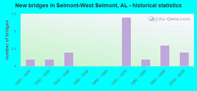
- New bridges - historical statistics
- 11920-1929
- 11930-1939
- 21940-1949
- 71970-1979
- 11980-1989
- 31990-1999
- 22000-2009

- Reconstructed bridges - Historical Statistics
- 11980-1989
- 11990-1999


- Bridge Condition - Deck
- 20.0%Very good
- 20.0%Good
- 40.0%Satisfactory
- 20.0%Fair

- Bridge Condition - Superstructure
- 10.0%Very good
- 30.0%Good
- 60.0%Satisfactory

- Bridge Condition - Substructure
- 10.0%Very good
- 50.0%Good
- 30.0%Satisfactory
- 10.0%Fair

- Bridge Condition - Channel
- 5.9%Very good
- 58.8%Good
- 29.4%Satisfactory
- 5.9%Fair

- Bridge Condition - Culverts
- 42.9%Good
- 57.1%Satisfactory
Find on map >> Show street view
Structure Number: 1199, Location: 1.3 MI E INT CHEROKEE #29 (Lat: 33.987194, Lng: -85.520469), Route carried "on" structure: County highway 8, Year Built: 1935, Status: Posted for load, Structure Length: 3.69m (12.11ft), Average Daily Traffic: 325 (year 2020), Truck Traffic: 5%, Average Future Daily Traffic: 450 (year 2040), Design Load: H 15, Features Intersected: HURRICANE CREEK
Minimum Vertical Clearance: 30+ m (98+ ft), Kilometerpoint: 0.010, Lanes on structure: 1, Owner: County Highway Agency, Approaching Roadway Width: 6.7m (22.0ft), Material/Design: Steel, Design/Construction: Stringer/Multi-beam, Number Of Spans In Main Unit: 3, Length of Maximum Span: 12.5m (41.0ft), Curb-To-Curb Width: 4.9m (16.1ft), Out-to-Out Width: 4.9m (16.1ft)
Condition: Deck: Good, Superstructure: Satisfactory, Substructure: Fair, Channel: Satisfactory, Operating Rating: 35.5 metric tons, Method Used To Determine Operating Rating: Load Factor (LF), Inventory Rating: 21.2 metric tons, Method Used To Determine Inventory Rating: Load Factor (LF), Structural Evaluation: Somewhat better than minimum adequacy, Deck Geometry: High priority of replacement, Waterway Adequacy: Better than present minimum criteria, Approach Roadway Alignment: Better than present minimum criteria, Bridge Posting: Required (Relationship of Operating Rating to Maximum Legal Load: 0.1 - 9.9% below), Length Of Structure Improvement: 4.61m (15.12ft), Designated Inspection Frequency: Every 24 months, Other Special Inspection Frequency: Every 12 months, Inspection Date: September 2020, Other Special Inspection Date: September 2021, Bridge Improvement Cost: $506,000, Roadway Improvement Cost: $51,000, Total Project Cost: $557,000 ( Estimate for 2022), Deck Structure Type: Concrete Cast-file-Place
Find on map >> Show street view
Structure Number: 2275, Location: 0.5 MI.W.OF AL.41 (Lat: 32.379017, Lng: -87.009817), Route carried "on" structure: US 80, Year Built: 1940, Status: Open, Structure Length: 10.06m (33.01ft), Average Daily Traffic: 5,235 (year 2013), Truck Traffic: 5%, Average Future Daily Traffic: 6,845 (year 2033), Design Load: H 20, Features Intersected: ALABAMA RIVER RELIEF
Minimum Vertical Clearance: 30+ m (98+ ft), Kilometerpoint: 140.330, Lanes on structure: 2, Base Highway Network: Yes, Owner: State Highway Agency, Approaching Roadway Width: 11.6m (38.1ft), Skew: 10 degrees, Material/Design: Concrete, Design/Construction: Tee Beam, Number Of Spans In Main Unit: 11, Length of Maximum Span: 9.1m (29.9ft), Curb or Sidewalk Widths: Left: 0.5m (1.6ft), Right: 1.2m (3.9ft), Curb-To-Curb Width: 7.3m (24.0ft), Out-to-Out Width: 9.0m (29.5ft)
Condition: Deck: Satisfactory, Superstructure: Satisfactory, Substructure: Satisfactory, Channel: Good, Operating Rating: 43.5 metric tons, Method Used To Determine Operating Rating: Field evaluation and documented engineering judgment, Inventory Rating: 32.7 metric tons, Method Used To Determine Inventory Rating: Field evaluation and documented engineering judgment, Structural Evaluation: Equal to present minimum criteria, Deck Geometry: High priority of replacement, Waterway Adequacy: Superior to present desirable criteria, Approach Roadway Alignment: Better than present minimum criteria, Length Of Structure Improvement: 10.99m (36.06ft), Designated Inspection Frequency: Every 24 months, Inspection Date: December 2021, Bridge Improvement Cost: $2,185,000, Roadway Improvement Cost: $219,000, Total Project Cost: $2,404,000 ( Estimate for 2022), Deck Structure Type: Concrete Cast-file-Place
Find on map >> Show street view
Structure Number: 2363, Location: 4.9 MI. N. SARDIS (Lat: 32.356525, Lng: -87.002017), Route carried "on" structure: State highway 41, Year Built: 1940, Status: Open, Structure Length: 0.67m (2.20ft), Average Daily Traffic: 4,830 (year 2013), Truck Traffic: 9%, Average Future Daily Traffic: 5,988 (year 2033), Design Load: H 15, Features Intersected: FOUR MILE CREEK
Minimum Vertical Clearance: 30+ m (98+ ft), Kilometerpoint: 196.042, Lanes on structure: 2, Owner: State Highway Agency, Approaching Roadway Width: 10.7m (35.1ft), Material/Design: Concrete continuous, Design/Construction: Culvert, Number Of Spans In Main Unit: 2, Length of Maximum Span: 3.0m (9.8ft)
Condition: Channel: Good, Culverts: Satisfactory, Operating Rating: 88.9 metric tons, Method Used To Determine Operating Rating: Load Factor (LF), Inventory Rating: 55.2 metric tons, Method Used To Determine Inventory Rating: Load Factor (LF), Structural Evaluation: Equal to present minimum criteria, Waterway Adequacy: Equal to present minimum criteria, Approach Roadway Alignment: Better than present minimum criteria, Length Of Structure Improvement: 1.30m (4.27ft), Designated Inspection Frequency: Every 24 months, Underwater Inspection Frequency: Every 24 months, Inspection Date: October 2020, Underwater Inspection Date: October 2020, Bridge Improvement Cost: $390,000, Roadway Improvement Cost: $39,000, Total Project Cost: $429,000 ( Estimate for 2022)
Find on map >> Show street view
Structure Number: 1034, Location: 1.0 MI.N.OF US 80 (Lat: 32.385117, Lng: -86.999917), Route carried "on" structure: State highway 41, Year Built: 1970, Status: Open, Structure Length: 46.15m (151.41ft), Average Daily Traffic: 10,540 (year 2013), Truck Traffic: 17%, Average Future Daily Traffic: 13,066 (year 2033), Design Load: HS 20, Features Intersected: ALABAMA RIVER
Minimum Vertical Clearance: 30+ m (98+ ft), Kilometerpoint: 199.395, Lanes on structure: 2, Owner: State Highway Agency, Approaching Roadway Width: 13.4m (44.0ft), Navigation Control: Yes ( Vertical Clearance: 12.8m (42.0ft), Horizontal Clearance: 63.4m (208.0ft)), Material/Design: Steel continuous, Design/Construction: Girder and Floorbeam System, Number Of Spans In Main Unit: 3, Number Of Approach Spans: 11, Length of Maximum Span: 67.1m (220.1ft), Curb-To-Curb Width: 11.9m (39.0ft), Out-to-Out Width: 13.0m (42.7ft)
Condition: Deck: Fair, Superstructure: Satisfactory, Substructure: Satisfactory, Channel: Good, Operating Rating: 37.5 metric tons, Method Used To Determine Operating Rating: Load Factor (LF), Inventory Rating: 22.4 metric tons, Method Used To Determine Inventory Rating: Load Factor (LF), Structural Evaluation: Somewhat better than minimum adequacy, Deck Geometry: Somewhat better than minimum adequacy, Waterway Adequacy: Superior to present desirable criteria, Approach Roadway Alignment: Better than present minimum criteria, Length Of Structure Improvement: 46.15m (151.41ft), Designated Inspection Frequency: Every 24 months, Critical Feature Inspection Frequency: Every 24 months, Underwater Inspection Frequency: Every 24 months, Inspection Date: October 2020, Critical Feature Inspection Date: October 2020, Underwater Inspection Date: December 2020, Bridge Improvement Cost: $13,291,000, Roadway Improvement Cost: $1,329,000, Total Project Cost: $14,620,000 ( Estimate for 2022), Deck Structure Type: Concrete Cast-file-Place
Find on map >> Show street view
Structure Number: 11631, Location: 3.0 MI.NORTH WETUMPKA (Lat: 32.602150, Lng: -86.214950), Route carried "on" structure: US 231, Year Built: 1976, Status: Open, Structure Length: 1.55m (5.09ft), Average Daily Traffic: 6,070 (year 2013), Truck Traffic: 5%, Average Future Daily Traffic: 7,570 (year 2033), Design Load: HS 20, Features Intersected: YELLOW WATER CREEK
Minimum Vertical Clearance: 30+ m (98+ ft), Kilometerpoint: 269.930, Lanes on structure: 2, Base Highway Network: Yes, Owner: State Highway Agency, Approaching Roadway Width: 13.4m (44.0ft), Material/Design: Concrete continuous, Design/Construction: Culvert, Number Of Spans In Main Unit: 4, Length of Maximum Span: 3.7m (12.1ft)
Condition: Channel: Satisfactory, Culverts: Satisfactory, Operating Rating: 88.9 metric tons, Method Used To Determine Operating Rating: Load Factor (LF), Inventory Rating: 57.0 metric tons, Method Used To Determine Inventory Rating: Load Factor (LF), Structural Evaluation: Equal to present minimum criteria, Waterway Adequacy: Superior to present desirable criteria, Approach Roadway Alignment: Better than present minimum criteria, Length Of Structure Improvement: 2.23m (7.32ft), Designated Inspection Frequency: Every 24 months, Inspection Date: May 2020, Bridge Improvement Cost: $1,367,000, Roadway Improvement Cost: $137,000, Total Project Cost: $1,504,000 ( Estimate for 2022)
Find on map >> Show street view
Structure Number: 11642, Location: SEC 32 T19N R19E (Lat: 32.586667, Lng: -86.195000), Route carried "on" structure: County highway 32, Year Built: 1976, Status: Open, Structure Length: 1.74m (5.71ft), Average Daily Traffic: 160 (year 1998), Truck Traffic: 20%, Average Future Daily Traffic: 180 (year 2031), Design Load: H 15, Features Intersected: TAYLOR CREEK, Facility Carried by Structure: Williams Road
Minimum Vertical Clearance: 30+ m (98+ ft), Kilometerpoint: 0.010, Lanes on structure: 2, Owner: County Highway Agency, Approaching Roadway Width: 8.5m (27.9ft), Material/Design: Concrete, Design/Construction: Channel Beam, Number Of Spans In Main Unit: 3, Length of Maximum Span: 5.8m (19.0ft), Curb-To-Curb Width: 7.9m (25.9ft), Out-to-Out Width: 8.5m (27.9ft)
Condition: Deck: Good, Superstructure: Good, Substructure: Good, Channel: Good, Operating Rating: 45.9 metric tons, Method Used To Determine Operating Rating: Load Factor (LF), Inventory Rating: 27.5 metric tons, Method Used To Determine Inventory Rating: Load Factor (LF), Structural Evaluation: Equal to present minimum criteria, Deck Geometry: Somewhat better than minimum adequacy, Waterway Adequacy: Somewhat better than minimum adequacy, Approach Roadway Alignment: Equal to present minimum criteria, Length Of Structure Improvement: 2.44m (8.01ft), Designated Inspection Frequency: Every 24 months, Inspection Date: Febuary 2022, Bridge Improvement Cost: $451,000, Roadway Improvement Cost: $45,000, Total Project Cost: $496,000 ( Estimate for 2022), Deck Structure Type: Concrete Precast Panels, Wearing Surface/Protective System: Wearing Surface: Bituminous
Find on map >> Show street view
Structure Number: 11643, Location: 7.8 MI E TALLADEGA LINE (Lat: 33.036900, Lng: -86.124200), Route carried "on" structure: State highway 38, Year Built: 1976, Status: Open, Structure Length: 13.60m (44.62ft), Average Daily Traffic: 5,547 (year 2018), Truck Traffic: 17%, Average Future Daily Traffic: 7,766 (year 2038), Design Load: HS 20, Features Intersected: HATCHET CREEK
Minimum Vertical Clearance: 30+ m (98+ ft), Kilometerpoint: 88.728, Lanes on structure: 2, Base Highway Network: Yes, Owner: State Highway Agency, Approaching Roadway Width: 13.4m (44.0ft), Skew: 4 degrees, Material/Design: Steel continuous, Design/Construction: Stringer/Multi-beam, Number Of Spans In Main Unit: 5, Length of Maximum Span: 30.5m (100.1ft), Curb-To-Curb Width: 12.0m (39.4ft), Out-to-Out Width: 12.5m (41.0ft)
Condition: Deck: Satisfactory, Superstructure: Good, Substructure: Good, Channel: Satisfactory, Operating Rating: 62.6 metric tons, Method Used To Determine Operating Rating: Allowable Stress (AS), Inventory Rating: 36.6 metric tons, Method Used To Determine Inventory Rating: Allowable Stress (AS), Structural Evaluation: Better than present minimum criteria, Deck Geometry: Better than present minimum criteria, Waterway Adequacy: Superior to present desirable criteria, Approach Roadway Alignment: Equal to present desirable criteria, Length Of Structure Improvement: 14.41m (47.28ft), Designated Inspection Frequency: Every 24 months, Inspection Date: June 2020, Bridge Improvement Cost: $4,050,000, Roadway Improvement Cost: $405,000, Total Project Cost: $4,455,000 ( Estimate for 2022), Deck Structure Type: Concrete Cast-file-Place
Find on map >> Show street view
Structure Number: 11989, Location: 0.8 MI W SPANISH FT (Lat: 30.668481, Lng: -87.927581), Route carried "on" structure: US 90, Year Built: 1978, Status: Open, Structure Length: 41.61m (136.52ft), Average Daily Traffic: 10,833 (year 2020), Truck Traffic: 4%, Average Future Daily Traffic: 16,249 (year 2040), Design Load: HS 20, Features Intersected: BLAKELEY RIVER
Minimum Vertical Clearance: 30+ m (98+ ft), Kilometerpoint: 68.333, Lanes on structure: 2, Owner: State Highway Agency, Approaching Roadway Width: 12.2m (40.0ft), Skew: 10 degrees, Material/Design: Prestressed concrete, Design/Construction: Stringer/Multi-beam, Number Of Spans In Main Unit: 21, Length of Maximum Span: 19.8m (65.0ft), Curb-To-Curb Width: 11.9m (39.0ft), Out-to-Out Width: 12.8m (42.0ft)
Condition: Deck: Satisfactory, Superstructure: Satisfactory, Substructure: Good, Channel: Satisfactory, Operating Rating: 52.6 metric tons, Method Used To Determine Operating Rating: Load Factor (LF), Inventory Rating: 34.6 metric tons, Method Used To Determine Inventory Rating: Load Factor (LF), Structural Evaluation: Equal to present minimum criteria, Deck Geometry: Better than present minimum criteria, Waterway Adequacy: Equal to present minimum criteria, Approach Roadway Alignment: Better than present minimum criteria, Length Of Structure Improvement: 41.61m (136.52ft), Designated Inspection Frequency: Every 24 months, Underwater Inspection Frequency: Every 24 months, Inspection Date: September 2021, Underwater Inspection Date: Febuary 2021, Bridge Improvement Cost: $11,982,000, Roadway Improvement Cost: $1,198,000, Total Project Cost: $13,180,000 ( Estimate for 2022), Deck Structure Type: Concrete Cast-file-Place
Find on map >> Show street view
Structure Number: 12183, Location: 0.2 E CO ROUTE 31 (Lat: 33.233283, Lng: -85.838356), Route carried "on" structure: County highway 45, Year Built: 1979, Status: Posted for load, Structure Length: 1.33m (4.36ft), Average Daily Traffic: 18 (year 2016), Average Future Daily Traffic: 27 (year 2036), Features Intersected: METCALF CREEK, Facility Carried by Structure: CREEK RD
Minimum Vertical Clearance: 30+ m (98+ ft), Kilometerpoint: 0.010, Lanes on structure: 1, Owner: County Highway Agency, Approaching Roadway Width: 4.9m (16.1ft), Material/Design: Steel, Design/Construction: Stringer/Multi-beam, Number Of Spans In Main Unit: 1, Length of Maximum Span: 12.4m (40.7ft), Curb-To-Curb Width: 4.6m (15.1ft), Out-to-Out Width: 4.6m (15.1ft)
Condition: Deck: Fair, Superstructure: Satisfactory, Substructure: Very good, Channel: Good, Operating Rating: 13.6 metric tons, Method Used To Determine Operating Rating: Load Factor (LF), Inventory Rating: 8.2 metric tons, Method Used To Determine Inventory Rating: Load Factor (LF), Structural Evaluation: High priority of replacement, Deck Geometry: Better than present minimum criteria, Waterway Adequacy: Better than present minimum criteria, Approach Roadway Alignment: Equal to present minimum criteria, Bridge Posting: Required (Relationship of Operating Rating to Maximum Legal Load: > 39.9% below), Length Of Structure Improvement: 2.01m (6.59ft), Designated Inspection Frequency: Every 24 months, Critical Feature Inspection Frequency: Every 6 months, Other Special Inspection Frequency: Every 6 months, Inspection Date: March 2021, Critical Feature Inspection Date: September 2021, Other Special Inspection Date: September 2021, Bridge Improvement Cost: $207,000, Roadway Improvement Cost: $21,000, Total Project Cost: $228,000 ( Estimate for 2022), Deck Structure Type: Wood or Timber, Wearing Surface/Protective System: Wearing Surface: Wood or Timber
Find on map >> Show street view
Structure Number: 12248, Location: 5.3 MI E OF AL 51 JCT (Lat: 32.085900, Lng: -85.542400), Route carried "on" structure: US 82, Year Built: 1927, Year Reconstructed: 1980, Status: Open, Structure Length: 1.01m (3.31ft), Average Daily Traffic: 2,270 (year 2013), Truck Traffic: 22%, Average Future Daily Traffic: 2,939 (year 2033), Design Load: H 15, Features Intersected: BRANCH
Minimum Vertical Clearance: 30+ m (98+ ft), Kilometerpoint: 339.195, Lanes on structure: 2, Owner: State Highway Agency, Approaching Roadway Width: 9.8m (32.2ft), Material/Design: Concrete continuous, Design/Construction: Culvert, Number Of Spans In Main Unit: 3, Length of Maximum Span: 3.0m (9.8ft)
Condition: Channel: Fair, Culverts: Satisfactory, Operating Rating: 80.7 metric tons, Method Used To Determine Operating Rating: Load Factor (LF), Inventory Rating: 48.4 metric tons, Method Used To Determine Inventory Rating: Load Factor (LF), Structural Evaluation: Equal to present minimum criteria, Waterway Adequacy: Better than present minimum criteria, Approach Roadway Alignment: Better than present minimum criteria, Length Of Structure Improvement: 1.68m (5.51ft), Designated Inspection Frequency: Every 24 months, Inspection Date: October 2021, Bridge Improvement Cost: $738,000, Roadway Improvement Cost: $74,000, Total Project Cost: $812,000 ( Estimate for 2022)
Find on map >> Show street view
Structure Number: 12512, Location: 2 MI W SR 41 S (Lat: 32.318786, Lng: -87.012375), Route carried "on" structure: County highway 139, Year Built: 1976, Status: Open, Structure Length: 1.52m (4.99ft), Average Daily Traffic: 50 (year 2012), Average Future Daily Traffic: 100 (year 2036), Design Load: H 10, Features Intersected: LIAS CREEK
Minimum Vertical Clearance: 30+ m (98+ ft), Kilometerpoint: 0.010, Lanes on structure: 2, Owner: County Highway Agency, Approaching Roadway Width: 7.9m (25.9ft), Skew: 3 degrees, Material/Design: Concrete, Design/Construction: Culvert, Number Of Spans In Main Unit: 4, Length of Maximum Span: 3.0m (9.8ft)
Condition: Channel: Satisfactory, Culverts: Good, Operating Rating: 88.9 metric tons, Method Used To Determine Operating Rating: Load Factor (LF), Inventory Rating: 88.9 metric tons, Method Used To Determine Inventory Rating: Load Factor (LF), Structural Evaluation: Better than present minimum criteria, Waterway Adequacy: Equal to present minimum criteria, Approach Roadway Alignment: Better than present minimum criteria, Length Of Structure Improvement: 2.20m (7.22ft), Designated Inspection Frequency: Every 24 months, Inspection Date: August 2020, Bridge Improvement Cost: $1,131,000, Roadway Improvement Cost: $113,000, Total Project Cost: $1,244,000 ( Estimate for 2022)
Find on map >> Show street view
Structure Number: 13443, Location: 3.5 MI W JCT SR 25 * 68 (Lat: 34.158019, Lng: -85.813747), Route carried "on" structure: US 411, Year Built: 1985, Year Reconstructed: 1998, Status: Open, Structure Length: 0.64m (2.10ft), Average Daily Traffic: 8,329 (year 2019), Truck Traffic: 12%, Average Future Daily Traffic: 11,661 (year 2039), Features Intersected: BRANCH
Minimum Vertical Clearance: 30+ m (98+ ft), Kilometerpoint: 374.485, Lanes on structure: 4, Owner: State Highway Agency, Approaching Roadway Width: 14.6m (47.9ft), Material/Design: Concrete, Design/Construction: Culvert, Number Of Spans In Main Unit: 2, Length of Maximum Span: 3.0m (9.8ft)
Condition: Channel: Good, Culverts: Good, Operating Rating: 88.9 metric tons, Method Used To Determine Operating Rating: Load Factor (LF), Inventory Rating: 57.2 metric tons, Method Used To Determine Inventory Rating: Load Factor (LF), Structural Evaluation: Better than present minimum criteria, Waterway Adequacy: Equal to present minimum criteria, Approach Roadway Alignment: Equal to present desirable criteria, Length Of Structure Improvement: 1.26m (4.13ft), Designated Inspection Frequency: Every 24 months, Inspection Date: May 2021, Bridge Improvement Cost: $1,907,000, Roadway Improvement Cost: $191,000, Total Project Cost: $2,098,000 ( Estimate for 2022), Wearing Surface/Protective System: Wearing Surface: Bituminous
Find on map >> Show street view
Structure Number: 1535, Location: 0.7 MI N OF CR 139 (Lat: 32.328881, Lng: -87.008319), Route carried "on" structure: County highway 77, Year Built: 1991, Status: Open, Structure Length: 6.22m (20.41ft), Average Daily Traffic: 200 (year 2012), Truck Traffic: 5%, Average Future Daily Traffic: 250 (year 2040), Design Load: HS 15, Features Intersected: SIX MILE CREEK
Minimum Vertical Clearance: 30+ m (98+ ft), Kilometerpoint: 0.010, Lanes on structure: 2, Owner: County Highway Agency, Approaching Roadway Width: 6.1m (20.0ft), Material/Design: Concrete, Design/Construction: Channel Beam, Number Of Spans In Main Unit: 6, Length of Maximum Span: 10.4m (34.1ft), Curb-To-Curb Width: 7.5m (24.6ft), Out-to-Out Width: 7.5m (24.6ft)
Condition: Deck: Satisfactory, Superstructure: Satisfactory, Substructure: Good, Channel: Very good, Operating Rating: 87.6 metric tons, Method Used To Determine Operating Rating: Load Factor (LF), Inventory Rating: 52.5 metric tons, Method Used To Determine Inventory Rating: Load Factor (LF), Structural Evaluation: Equal to present minimum criteria, Deck Geometry: Somewhat better than minimum adequacy, Waterway Adequacy: Equal to present desirable criteria, Approach Roadway Alignment: Better than present minimum criteria, Length Of Structure Improvement: 7.26m (23.82ft), Designated Inspection Frequency: Every 24 months, Inspection Date: June 2020, Bridge Improvement Cost: $1,194,000, Roadway Improvement Cost: $119,000, Total Project Cost: $1,313,000 ( Estimate for 2022), Deck Structure Type: Concrete Precast Panels
Find on map >> Show street view
Structure Number: 16827, Location: 0.2 MI S CR 139 (Lat: 32.307483, Lng: -86.992083), Route carried "on" structure: County highway 142, Year Built: 1996, Status: Posted for load, Structure Length: 1.22m (4.00ft), Average Daily Traffic: 30 (year 2011), Average Future Daily Traffic: 60 (year 2040), Design Load: H 15, Features Intersected: LIAS CREEK
Minimum Vertical Clearance: 30+ m (98+ ft), Kilometerpoint: 0.010, Lanes on structure: 1, Owner: County Highway Agency, Approaching Roadway Width: 6.1m (20.0ft), Material/Design: Steel continuous, Design/Construction: Stringer/Multi-beam, Number Of Spans In Main Unit: 2, Length of Maximum Span: 6.1m (20.0ft), Curb or Sidewalk Widths: Left: 0.2m (0.7ft), Right: 0.2m (0.7ft), Curb-To-Curb Width: 5.8m (19.0ft), Out-to-Out Width: 6.1m (20.0ft)
Condition: Deck: Very good, Superstructure: Good, Substructure: Satisfactory, Channel: Good, Operating Rating: 16.2 metric tons, Method Used To Determine Operating Rating: Load Factor (LF), Inventory Rating: 11.8 metric tons, Method Used To Determine Inventory Rating: Load Factor (LF), Structural Evaluation: Meets minimum limits, Deck Geometry: Meets minimum limits, Waterway Adequacy: Equal to present desirable criteria, Approach Roadway Alignment: Equal to present minimum criteria, Bridge Posting: Required (Relationship of Operating Rating to Maximum Legal Load: > 39.9% below), Length Of Structure Improvement: 1.89m (6.20ft), Designated Inspection Frequency: Every 24 months, Other Special Inspection Frequency: Every 12 months, Inspection Date: April 2020, Other Special Inspection Date: April 2021, Bridge Improvement Cost: $259,000, Roadway Improvement Cost: $26,000, Total Project Cost: $285,000 ( Estimate for 2022), Deck Structure Type: Wood or Timber, Wearing Surface/Protective System: Wearing Surface: Wood or Timber
Find on map >> Show street view
Structure Number: 1731, Location: 0.3 MI E CR 56 (Lat: 32.364167, Lng: -86.979094), Route carried "on" structure: County highway 74, Year Built: 1998, Status: Open, Structure Length: 1.04m (3.41ft), Average Daily Traffic: 350 (year 2010), Truck Traffic: 5%, Average Future Daily Traffic: 500 (year 2040), Design Load: H 15, Features Intersected: TARVER CREEK
Minimum Vertical Clearance: 30+ m (98+ ft), Kilometerpoint: 0.999, Lanes on structure: 2, Owner: County Highway Agency, Approaching Roadway Width: 6.1m (20.0ft), Material/Design: Concrete, Design/Construction: Channel Beam, Number Of Spans In Main Unit: 1, Length of Maximum Span: 10.4m (34.1ft), Curb or Sidewalk Widths: Left: 0.4m (1.3ft), Right: 0.4m (1.3ft), Curb-To-Curb Width: 8.7m (28.5ft), Out-to-Out Width: 9.4m (30.8ft)
Condition: Deck: Very good, Superstructure: Very good, Substructure: Good, Channel: Good, Operating Rating: 87.6 metric tons, Method Used To Determine Operating Rating: Load Factor (LF), Inventory Rating: 52.5 metric tons, Method Used To Determine Inventory Rating: Load Factor (LF), Structural Evaluation: Better than present minimum criteria, Deck Geometry: Equal to present minimum criteria, Waterway Adequacy: Equal to present minimum criteria, Approach Roadway Alignment: Better than present minimum criteria, Length Of Structure Improvement: 1.71m (5.61ft), Designated Inspection Frequency: Every 24 months, Inspection Date: April 2020, Bridge Improvement Cost: $351,000, Roadway Improvement Cost: $35,000, Total Project Cost: $386,000 ( Estimate for 2022), Deck Structure Type: Concrete Precast Panels
Find on map >> Show street view
Structure Number: 18344, Location: 2.5 MI. N. SARDIS (Lat: 32.321667, Lng: -86.993333), Route carried "on" structure: State highway 41, Year Built: 2004, Status: Open, Structure Length: 2.13m (6.99ft), Average Daily Traffic: 2,940 (year 2013), Truck Traffic: 10%, Average Future Daily Traffic: 3,645 (year 2033), Design Load: HS 20, Features Intersected: PINE FLAT CREEK
Minimum Vertical Clearance: 30+ m (98+ ft), Kilometerpoint: 191.832, Lanes on structure: 2, Owner: State Highway Agency, Approaching Roadway Width: 7.3m (24.0ft), Skew: 12 degrees, Material/Design: Concrete continuous, Design/Construction: Culvert, Number Of Spans In Main Unit: 4, Length of Maximum Span: 4.9m (16.1ft)
Condition: Channel: Good, Culverts: Satisfactory, Operating Rating: 88.9 metric tons, Method Used To Determine Operating Rating: Load Factor (LF), Inventory Rating: 88.9 metric tons, Method Used To Determine Inventory Rating: Load Factor (LF), Structural Evaluation: Equal to present minimum criteria, Waterway Adequacy: Superior to present desirable criteria, Approach Roadway Alignment: Better than present minimum criteria, Length Of Structure Improvement: 2.91m (9.55ft), Designated Inspection Frequency: Every 24 months, Inspection Date: November 2020, Bridge Improvement Cost: $2,844,000, Roadway Improvement Cost: $284,000, Total Project Cost: $3,128,000 ( Estimate for 2022)
Find on map >> Show street view
Structure Number: 19822, Location: 0.5 MI E SR 41 S (Lat: 32.322014, Lng: -86.979867), Route carried "on" structure: County highway , Year Built: 2005, Status: Open, Structure Length: 1.87m (6.14ft), Average Daily Traffic: 1,000 (year 2012), Truck Traffic: 8%, Average Future Daily Traffic: 1,500 (year 2040), Features Intersected: SIX MILE CREEK, Facility Carried by Structure: IND ACCESS ROAD
Minimum Vertical Clearance: 30+ m (98+ ft), Kilometerpoint: 0.010, Lanes on structure: 2, Owner: County Highway Agency, Approaching Roadway Width: 7.5m (24.6ft), Skew: 1 degrees, Material/Design: Concrete, Design/Construction: Culvert, Number Of Spans In Main Unit: 4, Length of Maximum Span: 4.3m (14.1ft)
Condition: Channel: Good, Culverts: Good, Operating Rating: 59.1 metric tons, Method Used To Determine Operating Rating: Load Factor (LF), Inventory Rating: 35.5 metric tons, Method Used To Determine Inventory Rating: Load Factor (LF), Structural Evaluation: Better than present minimum criteria, Waterway Adequacy: Equal to present desirable criteria, Approach Roadway Alignment: Equal to present desirable criteria, Length Of Structure Improvement: 2.60m (8.53ft), Designated Inspection Frequency: Every 24 months, Inspection Date: October 2020, Bridge Improvement Cost: $855,000, Roadway Improvement Cost: $86,000, Total Project Cost: $941,000 ( Estimate for 2022)