Bridge Statistics for Sewaren, New Jersey (NJ)
Condition, Traffic, Stress, Structural Evaluation, Project Costs
- National Bridge Inventory (NBI) Statistics
- 12Number of bridges
- 253ft / 77.0mTotal length
- $4,964,000Total costs
- 324,286Total average daily traffic
- 54,189Total average daily truck traffic
- National Bridge Inventory (NBI) Registered Bridges for Sewaren
- No street view available for this location
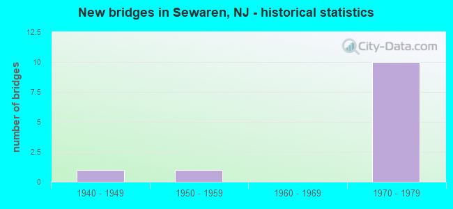
- New bridges - historical statistics
- 11940-1949
- 11950-1959
- 101970-1979


- Bridge Condition - Deck
- 33.3%Good
- 33.3%Satisfactory
- 33.3%Fair

- Bridge Condition - Superstructure
- 16.7%Good
- 66.7%Satisfactory
- 16.7%Poor

- Bridge Condition - Substructure
- 50.0%Satisfactory
- 50.0%Fair

- Bridge Condition - Channel
- 66.7%Very good
- 33.3%Good
Find on map >> Show street view
Structure Number: 121B049, Location: 0.1 MI. EAST OF NJ TURNPK (Lat: 40.553519, Lng: -74.266469), Route carried "on" structure: County highway 652, Year Built: 1950, Year Reconstructed: 1989, Status: Open, Structure Length: 2.68m (8.79ft), Average Daily Traffic: 7,883 (year 2021), Truck Traffic: 3%, Average Future Daily Traffic: 9,619 (year 2041), Design Load: HS 20+Mod, Features Intersected: WOODBRIDGE CREEK, Facility Carried by Structure: WOODBRIDGE AVENUE
Minimum Vertical Clearance: 30+ m (98+ ft), Kilometerpoint: 0.740, Lanes on structure: 2, Owner: County Highway Agency, Approaching Roadway Width: 12.2m (40.0ft), Material/Design: Prestressed concrete, Design/Construction: Box Beam or Girders - Multiple, Number Of Spans In Main Unit: 2, Length of Maximum Span: 12.8m (42.0ft), Curb or Sidewalk Widths: Left: 2.1m (6.9ft), Right: 1.9m (6.2ft), Curb-To-Curb Width: 12.2m (40.0ft), Out-to-Out Width: 16.9m (55.4ft)
Condition: Deck: Good, Superstructure: Good, Substructure: Satisfactory, Channel: Good, Operating Rating: 78.0 metric tons, Method Used To Determine Operating Rating: Load Factor (LF), Inventory Rating: 46.3 metric tons, Method Used To Determine Inventory Rating: Load Factor (LF), Structural Evaluation: Equal to present minimum criteria, Deck Geometry: Somewhat better than minimum adequacy, Waterway Adequacy: Better than present minimum criteria, Approach Roadway Alignment: Better than present minimum criteria, Designated Inspection Frequency: Every 24 months, Underwater Inspection Frequency: Every 48 months, Inspection Date: May 2021, Underwater Inspection Date: August 2019, Deck Structure Type: Concrete Cast-file-Place, Wearing Surface/Protective System: Wearing Surface: Monolithic Concrete, Deck Protection: Epoxy Coated Reinforcing
Find on map >> Show street view
Structure Number: 125016, Location: 0.33 mi S of CR 652 (Lat: 40.547119, Lng: -74.259250), Route carried "on" structure: County highway 611, Year Built: 1941, Status: Open, Structure Length: 6.19m (20.31ft), Average Daily Traffic: 15,164 (year 2021), Truck Traffic: 4%, Average Future Daily Traffic: 18,503 (year 2041), Design Load: H 20, Features Intersected: CHEMICAL COAST BRANCH
Minimum Vertical Clearance: 30+ m (98+ ft), Kilometerpoint: 4.554, Lanes on structure: 2, Maintenance Responsibility: State Highway Agency, Approaching Roadway Width: 12.8m (42.0ft), Skew: 6 degrees, Material/Design: Steel continuous, Design/Construction: Girder and Floorbeam System, Number Of Spans In Main Unit: 3, Length of Maximum Span: 27.7m (90.9ft), Curb or Sidewalk Widths: Left: 2.0m (6.6ft), Right: 2.0m (6.6ft), Curb-To-Curb Width: 12.8m (42.0ft), Out-to-Out Width: 13.0m (42.7ft)
Condition: Deck: Satisfactory, Superstructure: Poor, Substructure: Satisfactory, Operating Rating: 37.2 metric tons, Method Used To Determine Operating Rating: Load Factor (LF), Inventory Rating: 22.7 metric tons, Method Used To Determine Inventory Rating: Load Factor (LF), Structural Evaluation: Meets minimum limits, Deck Geometry: Somewhat better than minimum adequacy, Underclear: High priority of replacement, Approach Roadway Alignment: Somewhat better than minimum adequacy, Length Of Structure Improvement: 7.10m (23.29ft), Designated Inspection Frequency: Every 24 months, Critical Feature Inspection Frequency: Every 24 months, Inspection Date: September 2021, Critical Feature Inspection Date: September 2021, Bridge Improvement Cost: $3,260,000, Roadway Improvement Cost: $345,000, Total Project Cost: $4,964,000 ( Estimate for 2021), Deck Structure Type: Concrete Cast-file-Place, Wearing Surface/Protective System: Wearing Surface: Bituminous
Find on map >> Show street view
Structure Number: M09269A, Location: WOODBRIDGE SERVICE AREA (Lat: 40.555469, Lng: -74.266939), Route carried "on" structure: Ramp Interstate 95, Year Built: 1970, Year Reconstructed: 1991, Status: Open, Structure Length: 18.11m (59.42ft), Average Daily Traffic: 10,353 (year 2021), Truck Traffic: 1%, Average Future Daily Traffic: 12,633 (year 2041), Design Load: HS 20, Features Intersected: TPK SNO RDWY & RAMP SOSA, Facility Carried by Structure: SA 10N RAMP SISA
Minimum Vertical Clearance: 30+ m (98+ ft), Kilometerpoint: 76.219, Lanes on structure: 1, Lanes under structure: 5, Toll: On toll road, Owner: State Toll Authority, Approaching Roadway Width: 7.3m (24.0ft), Skew: 5 degrees, Material/Design: Steel, Design/Construction: Stringer/Multi-beam, Number Of Spans In Main Unit: 7, Length of Maximum Span: 79.6m (261.2ft), Curb or Sidewalk Widths: Left: 0.6m (2.0ft), Right: 0.6m (2.0ft), Curb-To-Curb Width: 7.3m (24.0ft), Out-to-Out Width: 9.1m (29.9ft)
Condition: Deck: Fair, Superstructure: Satisfactory, Substructure: Fair, Channel: Very good, Operating Rating: 65.1 metric tons, Method Used To Determine Operating Rating: Load and Resistance Factor Rating (LRFR) rating reported by rating factor(RF) method using HL-93 loadings, Inventory Rating: 50.2 metric tons, Method Used To Determine Inventory Rating: Load and Resistance Factor Rating (LRFR) rating reported by rating factor(RF) method using HL-93 loadings, Structural Evaluation: Somewhat better than minimum adequacy, Deck Geometry: Better than present minimum criteria, Underclear: Meets minimum limits, Waterway Adequacy: Superior to present desirable criteria, Approach Roadway Alignment: Better than present minimum criteria, Designated Inspection Frequency: Every 24 months, Critical Feature Inspection Frequency: Every 24 months, Inspection Date: May 2021, Critical Feature Inspection Date: May 2021, Deck Structure Type: Concrete Cast-file-Place, Wearing Surface/Protective System: Wearing Surface: Bituminous
Find on map >> Show street view
Structure Number: M09276A, Location: WOODBRIDGE SERVICE AREA (Lat: 40.556669, Lng: -74.266669), Route carried "on" structure: Ramp Interstate 95, Year Built: 1970, Year Reconstructed: 1991, Status: Open, Structure Length: 20.12m (66.01ft), Average Daily Traffic: 10,613 (year 2021), Truck Traffic: 1%, Average Future Daily Traffic: 12,950 (year 2041), Design Load: HS 20, Features Intersected: TURNPIKE NSO RDWY, Facility Carried by Structure: NJTPK SA 10S SASI
Minimum Vertical Clearance: 30+ m (98+ ft), Kilometerpoint: 76.267, Lanes on structure: 1, Lanes under structure: 4, Toll: On toll road, Owner: State Toll Authority, Approaching Roadway Width: 7.3m (24.0ft), Skew: 4 degrees, Material/Design: Steel, Design/Construction: Stringer/Multi-beam, Number Of Spans In Main Unit: 9, Length of Maximum Span: 51.2m (168.0ft), Curb or Sidewalk Widths: Left: 0.6m (2.0ft), Right: 0.6m (2.0ft), Curb-To-Curb Width: 7.3m (24.0ft), Out-to-Out Width: 9.1m (29.9ft)
Condition: Deck: Satisfactory, Superstructure: Satisfactory, Substructure: Satisfactory, Channel: Very good, Operating Rating: 53.1 metric tons, Method Used To Determine Operating Rating: Load and Resistance Factor Rating (LRFR) rating reported by rating factor(RF) method using HL-93 loadings, Inventory Rating: 40.8 metric tons, Method Used To Determine Inventory Rating: Load and Resistance Factor Rating (LRFR) rating reported by rating factor(RF) method using HL-93 loadings, Structural Evaluation: Equal to present minimum criteria, Deck Geometry: Better than present minimum criteria, Underclear: Meets minimum limits, Waterway Adequacy: Equal to present desirable criteria, Approach Roadway Alignment: Equal to present desirable criteria, Designated Inspection Frequency: Every 24 months, Critical Feature Inspection Frequency: Every 24 months, Inspection Date: April 2021, Critical Feature Inspection Date: April 2021, Deck Structure Type: Concrete Cast-file-Place, Wearing Surface/Protective System: Wearing Surface: Other
Find on map >> Show street view
Structure Number: M09311A, Location: WOODBRIDGE SERVICE AREA (Lat: 40.560169, Lng: -74.261550), Route carried "on" structure: Ramp Interstate 95, Year Built: 1970, Year Reconstructed: 1991, Status: Open, Structure Length: 14.39m (47.21ft), Average Daily Traffic: 9,989 (year 2021), Truck Traffic: 1%, Average Future Daily Traffic: 12,188 (year 2041), Design Load: HS 20, Features Intersected: NJ TPK SNO RDWY, Facility Carried by Structure: NJTPK SA 10N SANI
Minimum Vertical Clearance: 30+ m (98+ ft), Kilometerpoint: 76.894, Lanes on structure: 1, Lanes under structure: 4, Toll: On toll road, Owner: State Toll Authority, Approaching Roadway Width: 7.3m (24.0ft), Material/Design: Steel, Design/Construction: Stringer/Multi-beam, Number Of Spans In Main Unit: 6, Length of Maximum Span: 32.9m (107.9ft), Curb or Sidewalk Widths: Left: 0.6m (2.0ft), Right: 0.6m (2.0ft), Curb-To-Curb Width: 7.3m (24.0ft), Out-to-Out Width: 9.1m (29.9ft)
Condition: Deck: Fair, Superstructure: Satisfactory, Substructure: Fair, Operating Rating: 67.1 metric tons, Method Used To Determine Operating Rating: Load and Resistance Factor Rating (LRFR) rating reported by rating factor(RF) method using HL-93 loadings, Inventory Rating: 51.5 metric tons, Method Used To Determine Inventory Rating: Load and Resistance Factor Rating (LRFR) rating reported by rating factor(RF) method using HL-93 loadings, Structural Evaluation: Somewhat better than minimum adequacy, Deck Geometry: Better than present minimum criteria, Underclear: Meets minimum limits, Approach Roadway Alignment: Better than present minimum criteria, Designated Inspection Frequency: Every 24 months, Critical Feature Inspection Frequency: Every 24 months, Inspection Date: April 2021, Critical Feature Inspection Date: April 2021, Deck Structure Type: Concrete Cast-file-Place, Wearing Surface/Protective System: Wearing Surface: Bituminous
Find on map >> Show street view
Structure Number: M09314A, Location: WOODBRIDGE SERVICE AREA (Lat: 40.561189, Lng: -74.261989), Route carried "on" structure: Ramp Interstate 95, Year Built: 1970, Year Reconstructed: 1991, Status: Open, Structure Length: 15.48m (50.79ft), Average Daily Traffic: 9,552 (year 2021), Truck Traffic: 1%, Average Future Daily Traffic: 11,656 (year 2041), Design Load: HS 20, Features Intersected: TPK NSO RDWY & RAMP NOSA, Facility Carried by Structure: TPK RAMP NISA
Minimum Vertical Clearance: 30+ m (98+ ft), Kilometerpoint: 76.927, Lanes on structure: 1, Lanes under structure: 5, Toll: On toll road, Owner: State Toll Authority, Approaching Roadway Width: 7.3m (24.0ft), Material/Design: Steel, Design/Construction: Stringer/Multi-beam, Number Of Spans In Main Unit: 6, Length of Maximum Span: 41.5m (136.2ft), Curb or Sidewalk Widths: Left: 0.6m (2.0ft), Right: 0.6m (2.0ft), Curb-To-Curb Width: 7.3m (24.0ft), Out-to-Out Width: 9.1m (29.9ft)
Condition: Deck: Good, Superstructure: Satisfactory, Substructure: Fair, Operating Rating: 41.5 metric tons, Method Used To Determine Operating Rating: Load and Resistance Factor Rating (LRFR) rating reported by rating factor(RF) method using HL-93 loadings, Inventory Rating: 32.1 metric tons, Method Used To Determine Inventory Rating: Load and Resistance Factor Rating (LRFR) rating reported by rating factor(RF) method using HL-93 loadings, Structural Evaluation: Somewhat better than minimum adequacy, Deck Geometry: Better than present minimum criteria, Underclear: Somewhat better than minimum adequacy, Approach Roadway Alignment: Better than present minimum criteria, Designated Inspection Frequency: Every 24 months, Critical Feature Inspection Frequency: Every 24 months, Inspection Date: April 2021, Critical Feature Inspection Date: April 2021, Deck Structure Type: Concrete Cast-file-Place, Wearing Surface/Protective System: Wearing Surface: Other
Find on map >> Show street view
Structure Number: M09269A, Location: WOODBRIDGE SERVICE AREA (Lat: 40.555469, Lng: -74.266939), Route carried "under" structure: Interstate 95, Year Built: 1970, Structure Length: 0. m, Average Daily Traffic: 45,886 (year 2021), Truck Traffic: 18%, Features Intersected: TPK SNO RDWY & RAMP SOSA, Facility Carried by Structure: SA 10N RAMP SISA
Minimum Vertical Clearance: 5.51m (18.08ft), Kilometerpoint: 76.219, Lanes on structure: 1, Lanes under structure: 4, Toll: On toll road, Material/Design: Steel, Design/Construction: Stringer/Multi-beam, Length of Maximum Span: 79.6m (261.2ft)
Find on map >> Show street view
Structure Number: M09269A, Location: WOODBRIDGE SERVICE AREA (Lat: 40.555469, Lng: -74.266939), Route carried "under" structure: Ramp Interstate 95, Year Built: 1970, Structure Length: 0. m, Average Daily Traffic: 5,082 (year 2021), Truck Traffic: 18%, Features Intersected: TPK SNO RDWY & RAMP SOSA, Facility Carried by Structure: SA 10N RAMP SISA
Minimum Vertical Clearance: 6.00m (19.69ft), Kilometerpoint: 76.219, Lanes on structure: 1, Lanes under structure: 1, Toll: On toll road, Material/Design: Steel, Design/Construction: Stringer/Multi-beam, Length of Maximum Span: 79.6m (261.2ft)
Find on map >> Show street view
Structure Number: M09276A, Location: WOODBRIDGE SERVICE AREA (Lat: 40.556669, Lng: -74.266669), Route carried "under" structure: Interstate 95, Year Built: 1970, Structure Length: 0. m, Average Daily Traffic: 104,591 (year 2021), Truck Traffic: 23%, Features Intersected: TURNPIKE NSO RDWY, Facility Carried by Structure: NJTPK SA 10S SASI
Minimum Vertical Clearance: 4.90m (16.08ft), Kilometerpoint: 76.267, Lanes on structure: 1, Lanes under structure: 4, Toll: On toll road, Material/Design: Steel, Design/Construction: Stringer/Multi-beam, Length of Maximum Span: 51.2m (168.0ft)
Find on map >> Show street view
Structure Number: M09311A, Location: WOODBRIDGE SERVICE AREA (Lat: 40.560169, Lng: -74.261550), Route carried "under" structure: Interstate 95, Year Built: 1970, Structure Length: 0. m, Average Daily Traffic: 47,863 (year 2021), Truck Traffic: 22%, Features Intersected: NJ TPK SNO RDWY, Facility Carried by Structure: NJTPK SA 10N SANI
Minimum Vertical Clearance: 4.65m (15.26ft), Kilometerpoint: 76.894, Lanes on structure: 1, Lanes under structure: 4, Toll: On toll road, Material/Design: Steel, Design/Construction: Stringer/Multi-beam, Length of Maximum Span: 32.9m (107.9ft)
Find on map >> Show street view
Structure Number: M09314A, Location: WOODBRIDGE SERVICE AREA (Lat: 40.561189, Lng: -74.261989), Route carried "under" structure: Interstate 95, Year Built: 1970, Structure Length: 0. m, Average Daily Traffic: 47,863 (year 2021), Truck Traffic: 19%, Features Intersected: TPK NSO RDWY & RAMP NOSA, Facility Carried by Structure: TPK RAMP NISA
Minimum Vertical Clearance: 5.26m (17.26ft), Kilometerpoint: 76.927, Lanes on structure: 1, Lanes under structure: 4, Toll: On toll road, Material/Design: Steel, Design/Construction: Stringer/Multi-beam, Length of Maximum Span: 41.5m (136.2ft)
Find on map >> Show street view
Structure Number: M09314A, Location: WOODBRIDGE SERVICE AREA (Lat: 40.561189, Lng: -74.261989), Route carried "under" structure: Ramp Interstate 95, Year Built: 1970, Structure Length: 0. m, Average Daily Traffic: 9,447 (year 2021), Truck Traffic: 1%, Features Intersected: TPK NSO RDWY & RAMP NOSA, Facility Carried by Structure: TPK RAMP NISA
Minimum Vertical Clearance: 5.64m (18.50ft), Kilometerpoint: 76.927, Lanes on structure: 1, Lanes under structure: 1, Toll: On toll road, Material/Design: Steel, Design/Construction: Stringer/Multi-beam, Length of Maximum Span: 41.5m (136.2ft)