Bridge Statistics for Seymour, Texas (TX)
Condition, Traffic, Stress, Structural Evaluation, Project Costs
- National Bridge Inventory (NBI) Statistics
- 30Number of bridges
- 502ft / 153mTotal length
- $100,000Total costs
- 60,221Total average daily traffic
- 17,020Total average daily truck traffic
- National Bridge Inventory (NBI) Registered Bridges for Seymour
- No street view available for this location
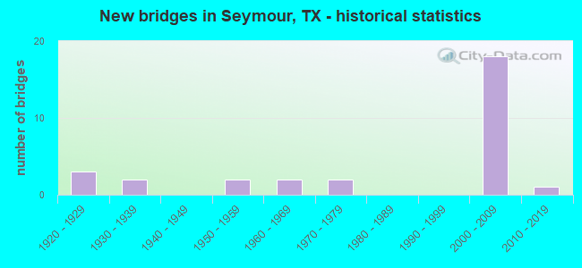
- New bridges - historical statistics
- 31920-1929
- 21930-1939
- 21950-1959
- 21960-1969
- 21970-1979
- 182000-2009
- 12010-2019

- Reconstructed bridges - Historical Statistics
- 11930-1939
- 11940-1949
- 11950-1959
- 01960-1969
- 11970-1979
- 01980-1989
- 11990-1999


- Bridge Condition - Superstructure
- 45.5%Very good
- 54.5%Good

- Bridge Condition - Substructure
- 81.8%Good
- 18.2%Satisfactory

- Bridge Condition - Channel
- 7.1%Very good
- 78.6%Good
- 14.3%Satisfactory

- Bridge Condition - Culverts
- 81.8%Good
- 18.2%Satisfactory
Find on map >> Show street view
Structure Number: 30120012405018, Location: 9.3MI N OF US 82/277 (Lat: 33.798325, Lng: -99.152267), Route carried "on" structure: US 183, Year Built: 1933, Year Reconstructed: 1996, Status: Open, Structure Length: 0.82m (2.69ft), Average Daily Traffic: 580 (year 2020), Truck Traffic: 24%, Average Future Daily Traffic: 812 (year 2040), Design Load: H 15, Features Intersected: WHISKEY CREEK
Minimum Vertical Clearance: 30+ m (98+ ft), Kilometerpoint: 4.862, Lanes on structure: 2, Owner: State Highway Agency, Approaching Roadway Width: 8.9m (29.2ft), Material/Design: Concrete, Design/Construction: Culvert, Number Of Spans In Main Unit: 3, Length of Maximum Span: 2.4m (7.9ft)
Condition: Channel: Good, Culverts: Good, Operating Rating: 32.7 metric tons, Method Used To Determine Operating Rating: No rating analysis performed, Inventory Rating: 24.5 metric tons, Method Used To Determine Inventory Rating: No rating analysis performed, Structural Evaluation: Equal to present minimum criteria, Waterway Adequacy: Equal to present minimum criteria, Approach Roadway Alignment: Equal to present desirable criteria, Designated Inspection Frequency: Every 24 months, Inspection Date: October 2021
Find on map >> Show street view
Structure Number: 30120013304007, Location: 0.7 MI W OF US 277 (Lat: 33.594175, Lng: -99.272600), Route carried "on" structure: US 82, Year Built: 1925, Year Reconstructed: 1953, Status: Open, Structure Length: 0.91m (2.99ft), Average Daily Traffic: 3,263 (year 2020), Truck Traffic: 14%, Average Future Daily Traffic: 4,568 (year 2040), Design Load: H 15, Features Intersected: PLANTS CREEK
Minimum Vertical Clearance: 30+ m (98+ ft), Kilometerpoint: 19.074, Lanes on structure: 3, Owner: State Highway Agency, Approaching Roadway Width: 20.2m (66.3ft), Material/Design: Concrete, Design/Construction: Culvert, Number Of Spans In Main Unit: 3, Length of Maximum Span: 3.0m (9.8ft), Curb-To-Curb Width: 20.2m (66.3ft), Out-to-Out Width: 21.0m (68.9ft)
Condition: Channel: Good, Culverts: Good, Operating Rating: 32.7 metric tons, Method Used To Determine Operating Rating: Field evaluation and documented engineering judgment, Inventory Rating: 24.5 metric tons, Method Used To Determine Inventory Rating: Field evaluation and documented engineering judgment, Structural Evaluation: Equal to present minimum criteria, Deck Geometry: Superior to present desirable criteria, Waterway Adequacy: Equal to present minimum criteria, Approach Roadway Alignment: Equal to present desirable criteria, Designated Inspection Frequency: Every 24 months, Inspection Date: October 2021, Deck Structure Type: Concrete Cast-file-Place, Wearing Surface/Protective System: Wearing Surface: Bituminous
Find on map >> Show street view
Structure Number: 30120013305008, Location: 0.5MI E OF US 277 (Lat: 33.584425, Lng: -99.252489), Route carried "on" structure: State highway 114, Year Built: 1929, Year Reconstructed: 1957, Status: Open, Structure Length: 1.28m (4.20ft), Average Daily Traffic: 1,198 (year 2020), Truck Traffic: 42%, Average Future Daily Traffic: 1,677 (year 2040), Design Load: H 15, Features Intersected: SEYMOUR CREEK
Minimum Vertical Clearance: 30+ m (98+ ft), Kilometerpoint: 0.811, Lanes on structure: 2, Owner: State Highway Agency, Approaching Roadway Width: 12.8m (42.0ft), Material/Design: Concrete, Design/Construction: Culvert, Number Of Spans In Main Unit: 4, Length of Maximum Span: 3.0m (9.8ft)
Condition: Channel: Good, Culverts: Satisfactory, Operating Rating: 39.9 metric tons, Method Used To Determine Operating Rating: Load Factor (LF), Inventory Rating: 23.6 metric tons, Method Used To Determine Inventory Rating: Load Factor (LF), Structural Evaluation: Equal to present minimum criteria, Waterway Adequacy: Equal to present minimum criteria, Approach Roadway Alignment: Equal to present desirable criteria, Designated Inspection Frequency: Every 24 months, Inspection Date: October 2021
Find on map >> Show street view
Structure Number: 30120013305009, Location: 3.3 MI SE OF US 277 (Lat: 33.561311, Lng: -99.213889), Route carried "on" structure: State highway 114, Year Built: 1929, Year Reconstructed: 1941, Status: Open, Structure Length: 1.04m (3.41ft), Average Daily Traffic: 952 (year 2020), Truck Traffic: 48%, Average Future Daily Traffic: 1,333 (year 2040), Features Intersected: ROCK CREEK
Minimum Vertical Clearance: 30+ m (98+ ft), Kilometerpoint: 5.269, Lanes on structure: 2, Owner: State Highway Agency, Approaching Roadway Width: 12.5m (41.0ft), Material/Design: Concrete, Design/Construction: Culvert, Number Of Spans In Main Unit: 4, Length of Maximum Span: 2.4m (7.9ft), Curb-To-Curb Width: 12.1m (39.7ft), Out-to-Out Width: 12.8m (42.0ft)
Condition: Channel: Good, Culverts: Satisfactory, Operating Rating: 32.7 metric tons, Method Used To Determine Operating Rating: Field evaluation and documented engineering judgment, Inventory Rating: 24.5 metric tons, Method Used To Determine Inventory Rating: Field evaluation and documented engineering judgment, Structural Evaluation: Equal to present minimum criteria, Deck Geometry: Better than present minimum criteria, Waterway Adequacy: Equal to present minimum criteria, Approach Roadway Alignment: Equal to present desirable criteria, Length Of Structure Improvement: 1.80m (5.91ft), Designated Inspection Frequency: Every 24 months, Inspection Date: October 2021, Bridge Improvement Cost: $80,000, Roadway Improvement Cost: $20,000, Total Project Cost: $100,000, Deck Structure Type: Concrete Cast-file-Place, Wearing Surface/Protective System: Wearing Surface: Bituminous
Find on map >> Show street view
Structure Number: 30120015606058, Location: 0.3 MI E OF FM 1919 (Lat: 33.611564, Lng: -99.254014), Route carried "on" structure: US 82, Year Built: 1970, Status: Open, Structure Length: 0.79m (2.59ft), Average Daily Traffic: 1,962 (year 2020), Truck Traffic: 26%, Average Future Daily Traffic: 2,530 (year 2033), Features Intersected: DRAW
Minimum Vertical Clearance: 30+ m (98+ ft), Kilometerpoint: 3.533, Lanes on structure: 2, Owner: State Highway Agency, Approaching Roadway Width: 13.0m (42.7ft), Material/Design: Concrete, Design/Construction: Culvert, Number Of Spans In Main Unit: 4, Length of Maximum Span: 1.8m (5.9ft), Curb-To-Curb Width: 21.3m (69.9ft), Out-to-Out Width: 21.9m (71.9ft)
Condition: Channel: Good, Culverts: Good, Operating Rating: 32.7 metric tons, Method Used To Determine Operating Rating: Field evaluation and documented engineering judgment, Inventory Rating: 24.5 metric tons, Method Used To Determine Inventory Rating: Field evaluation and documented engineering judgment, Structural Evaluation: Equal to present minimum criteria, Deck Geometry: Superior to present desirable criteria, Waterway Adequacy: Equal to present minimum criteria, Approach Roadway Alignment: Equal to present desirable criteria, Designated Inspection Frequency: Every 24 months, Inspection Date: October 2021, Deck Structure Type: Concrete Cast-file-Place, Wearing Surface/Protective System: Wearing Surface: Bituminous
Find on map >> Show street view
Structure Number: 30120015615016, Location: 0.2 MI N OF US 183/283 (Lat: 33.579122, Lng: -99.269372), Route carried "on" structure: US 277, Year Built: 2008, Status: Open, Structure Length: 29.57m (97.01ft), Average Daily Traffic: 3,731 (year 2020), Truck Traffic: 33%, Average Future Daily Traffic: 5,503 (year 2040), Design Load: HS 20, Features Intersected: BRAZOS RIVER
Minimum Vertical Clearance: 30+ m (98+ ft), Kilometerpoint: 36.001, Lanes on structure: 2, Owner: State Highway Agency, Approaching Roadway Width: 11.7m (38.4ft), Material/Design: Steel, Design/Construction: Stringer/Multi-beam, Number Of Spans In Main Unit: 1, Number Of Approach Spans: 8, Length of Maximum Span: 54.9m (180.1ft), Curb-To-Curb Width: 11.6m (38.1ft), Out-to-Out Width: 12.2m (40.0ft)
Condition: Deck: Good, Superstructure: Very good, Substructure: Satisfactory, Channel: Satisfactory, Operating Rating: 54.4 metric tons, Method Used To Determine Operating Rating: Assigned rating based on Load Factor Design (LFD) reported in metric tons, Inventory Rating: 32.7 metric tons, Method Used To Determine Inventory Rating: Assigned rating based on Load Factor Design (LFD) reported in metric tons, Structural Evaluation: Equal to present minimum criteria, Deck Geometry: Better than present minimum criteria, Waterway Adequacy: Superior to present desirable criteria, Approach Roadway Alignment: Equal to present desirable criteria, Designated Inspection Frequency: Every 24 months, Inspection Date: October 2021, Deck Structure Type: Concrete Precast Panels, Wearing Surface/Protective System: Wearing Surface: Monolithic Concrete, Deck Protection: Epoxy Coated Reinforcing
Find on map >> Show street view
Structure Number: 30120015615018, Location: 0.2 MI N OF US 183/283 (Lat: 33.579444, Lng: -99.266389), Route carried "on" structure: US 277, Year Built: 2008, Status: Open, Structure Length: 29.57m (97.01ft), Average Daily Traffic: 3,531 (year 2020), Truck Traffic: 33%, Average Future Daily Traffic: 5,503 (year 2040), Design Load: HS 20, Features Intersected: BRAZOS RIVER
Minimum Vertical Clearance: 30+ m (98+ ft), Kilometerpoint: 36.001, Lanes on structure: 2, Owner: State Highway Agency, Approaching Roadway Width: 11.5m (37.7ft), Material/Design: Steel, Design/Construction: Stringer/Multi-beam, Number Of Spans In Main Unit: 1, Number Of Approach Spans: 8, Length of Maximum Span: 54.9m (180.1ft), Curb-To-Curb Width: 11.6m (38.1ft), Out-to-Out Width: 12.2m (40.0ft)
Condition: Deck: Good, Superstructure: Very good, Substructure: Good, Channel: Good, Operating Rating: 54.4 metric tons, Method Used To Determine Operating Rating: Assigned rating based on Load Factor Design (LFD) reported in metric tons, Inventory Rating: 32.7 metric tons, Method Used To Determine Inventory Rating: Assigned rating based on Load Factor Design (LFD) reported in metric tons, Structural Evaluation: Better than present minimum criteria, Deck Geometry: Better than present minimum criteria, Waterway Adequacy: Superior to present desirable criteria, Approach Roadway Alignment: Equal to present desirable criteria, Designated Inspection Frequency: Every 24 months, Inspection Date: October 2021, Deck Structure Type: Concrete Precast Panels, Wearing Surface/Protective System: Wearing Surface: Monolithic Concrete, Deck Protection: Epoxy Coated Reinforcing
Find on map >> Show street view
Structure Number: 30120015615093, Location: 4.03 MI N OF US 183/283 (Lat: 33.615417, Lng: -99.242633), Route carried "on" structure: US 277, Year Built: 2008, Status: Open, Structure Length: 6.13m (20.11ft), Average Daily Traffic: 361 (year 2020), Truck Traffic: 38%, Average Future Daily Traffic: 6,122 (year 2040), Design Load: HS 20, Features Intersected: BU 277
Minimum Vertical Clearance: 30+ m (98+ ft), Kilometerpoint: 30.145, Lanes on structure: 2, Lanes under structure: 2, Owner: State Highway Agency, Approaching Roadway Width: 11.6m (38.1ft), Material/Design: Prestressed concrete continuous, Design/Construction: Stringer/Multi-beam, Number Of Spans In Main Unit: 3, Length of Maximum Span: 20.4m (66.9ft), Curb-To-Curb Width: 11.6m (38.1ft), Out-to-Out Width: 12.2m (40.0ft)
Condition: Deck: Good, Superstructure: Very good, Substructure: Good, Operating Rating: 54.4 metric tons, Method Used To Determine Operating Rating: Assigned rating based on Load Factor Design (LFD) reported in metric tons, Inventory Rating: 32.7 metric tons, Method Used To Determine Inventory Rating: Assigned rating based on Load Factor Design (LFD) reported in metric tons, Structural Evaluation: Better than present minimum criteria, Deck Geometry: Better than present minimum criteria, Underclear: Equal to present minimum criteria, Approach Roadway Alignment: Equal to present desirable criteria, Designated Inspection Frequency: Every 24 months, Inspection Date: October 2021, Deck Structure Type: Concrete Precast Panels, Wearing Surface/Protective System: Wearing Surface: Monolithic Concrete
Find on map >> Show street view
Structure Number: 30120015615094, Location: 4.03 MI N OF US 183/283 (Lat: 33.615556, Lng: -99.242778), Route carried "on" structure: US 277, Year Built: 2008, Status: Open, Structure Length: 6.13m (20.11ft), Average Daily Traffic: 1,503 (year 2020), Truck Traffic: 38%, Average Future Daily Traffic: 6,122 (year 2040), Design Load: HS 20, Features Intersected: BU 277
Minimum Vertical Clearance: 30+ m (98+ ft), Kilometerpoint: 30.145, Lanes on structure: 2, Lanes under structure: 2, Owner: State Highway Agency, Approaching Roadway Width: 11.6m (38.1ft), Material/Design: Prestressed concrete, Design/Construction: Stringer/Multi-beam, Number Of Spans In Main Unit: 3, Length of Maximum Span: 20.4m (66.9ft), Curb-To-Curb Width: 11.6m (38.1ft), Out-to-Out Width: 12.2m (40.0ft)
Condition: Deck: Good, Superstructure: Very good, Substructure: Good, Operating Rating: 54.4 metric tons, Method Used To Determine Operating Rating: Assigned rating based on Load Factor Design (LFD) reported in metric tons, Inventory Rating: 32.7 metric tons, Method Used To Determine Inventory Rating: Assigned rating based on Load Factor Design (LFD) reported in metric tons, Structural Evaluation: Better than present minimum criteria, Deck Geometry: Better than present minimum criteria, Underclear: Equal to present minimum criteria, Approach Roadway Alignment: Equal to present desirable criteria, Designated Inspection Frequency: Every 24 months, Inspection Date: October 2021, Deck Structure Type: Concrete Precast Panels, Wearing Surface/Protective System: Wearing Surface: Monolithic Concrete
Find on map >> Show street view
Structure Number: 30120015615095, Location: 2.66 MI N OF US 183/283 (Lat: 33.596017, Lng: -99.241078), Route carried "on" structure: US 277, Year Built: 2008, Status: Open, Structure Length: 7.16m (23.49ft), Average Daily Traffic: 1,558 (year 2020), Truck Traffic: 42%, Average Future Daily Traffic: 4,100 (year 2032), Design Load: HS 20, Features Intersected: FM 422
Minimum Vertical Clearance: 30+ m (98+ ft), Kilometerpoint: 32.345, Lanes on structure: 2, Lanes under structure: 2, Owner: State Highway Agency, Approaching Roadway Width: 11.6m (38.1ft), Material/Design: Prestressed concrete continuous, Design/Construction: Stringer/Multi-beam, Number Of Spans In Main Unit: 1, Number Of Approach Spans: 2, Length of Maximum Span: 30.5m (100.1ft), Curb-To-Curb Width: 11.6m (38.1ft), Out-to-Out Width: 12.2m (40.0ft)
Condition: Deck: Good, Superstructure: Good, Substructure: Good, Operating Rating: 54.4 metric tons, Method Used To Determine Operating Rating: Assigned rating based on Load Factor Design (LFD) reported in metric tons, Inventory Rating: 32.7 metric tons, Method Used To Determine Inventory Rating: Assigned rating based on Load Factor Design (LFD) reported in metric tons, Structural Evaluation: Better than present minimum criteria, Deck Geometry: Better than present minimum criteria, Underclear: Superior to present desirable criteria, Approach Roadway Alignment: Equal to present desirable criteria, Designated Inspection Frequency: Every 24 months, Inspection Date: October 2021, Deck Structure Type: Concrete Precast Panels, Wearing Surface/Protective System: Wearing Surface: Monolithic Concrete
Find on map >> Show street view
Structure Number: 30120015615111, Location: 2.66 MI N OF US 183/283 (Lat: 33.596111, Lng: -99.241389), Route carried "on" structure: US 277, Year Built: 2008, Status: Open, Structure Length: 7.16m (23.49ft), Average Daily Traffic: 1,503 (year 2020), Truck Traffic: 42%, Average Future Daily Traffic: 5,114 (year 2040), Design Load: HS 20, Features Intersected: FM 422
Minimum Vertical Clearance: 30+ m (98+ ft), Kilometerpoint: 32.345, Lanes on structure: 2, Lanes under structure: 2, Owner: State Highway Agency, Approaching Roadway Width: 11.6m (38.1ft), Material/Design: Prestressed concrete continuous, Design/Construction: Stringer/Multi-beam, Number Of Spans In Main Unit: 1, Number Of Approach Spans: 2, Length of Maximum Span: 30.5m (100.1ft), Curb-To-Curb Width: 11.6m (38.1ft), Out-to-Out Width: 12.2m (40.0ft)
Condition: Deck: Good, Superstructure: Very good, Substructure: Good, Operating Rating: 54.4 metric tons, Method Used To Determine Operating Rating: Assigned rating based on Load Factor Design (LFD) reported in metric tons, Inventory Rating: 32.7 metric tons, Method Used To Determine Inventory Rating: Assigned rating based on Load Factor Design (LFD) reported in metric tons, Structural Evaluation: Better than present minimum criteria, Deck Geometry: Better than present minimum criteria, Underclear: Superior to present desirable criteria, Approach Roadway Alignment: Equal to present desirable criteria, Designated Inspection Frequency: Every 24 months, Inspection Date: October 2021, Deck Structure Type: Concrete Precast Panels, Wearing Surface/Protective System: Wearing Surface: Monolithic Concrete
Find on map >> Show street view
Structure Number: 30120015615112, Location: 0.76 MI N OF US 183/283 (Lat: 33.579167, Lng: -99.260278), Route carried "on" structure: US 277, Year Built: 2008, Status: Open, Structure Length: 6.55m (21.49ft), Average Daily Traffic: 3,931 (year 2020), Truck Traffic: 25%, Average Future Daily Traffic: 5,503 (year 2040), Design Load: HS 20, Features Intersected: MAIN STREET
Minimum Vertical Clearance: 30+ m (98+ ft), Kilometerpoint: 35.367, Lanes on structure: 2, Lanes under structure: 4, Owner: State Highway Agency, Approaching Roadway Width: 11.6m (38.1ft), Material/Design: Prestressed concrete continuous, Design/Construction: Stringer/Multi-beam, Number Of Spans In Main Unit: 3, Length of Maximum Span: 25.9m (85.0ft), Curb-To-Curb Width: 11.6m (38.1ft), Out-to-Out Width: 12.2m (40.0ft)
Condition: Deck: Good, Superstructure: Good, Substructure: Good, Operating Rating: 54.4 metric tons, Method Used To Determine Operating Rating: Assigned rating based on Load Factor Design (LFD) reported in metric tons, Inventory Rating: 32.7 metric tons, Method Used To Determine Inventory Rating: Assigned rating based on Load Factor Design (LFD) reported in metric tons, Structural Evaluation: Better than present minimum criteria, Deck Geometry: Better than present minimum criteria, Underclear: Superior to present desirable criteria, Approach Roadway Alignment: Equal to present desirable criteria, Designated Inspection Frequency: Every 24 months, Inspection Date: October 2021, Deck Structure Type: Concrete Precast Panels, Wearing Surface/Protective System: Wearing Surface: Monolithic Concrete
Find on map >> Show street view
Structure Number: 30120015615113, Location: 0.76 MI N OF US 183/283 (Lat: 33.579500, Lng: -99.259811), Route carried "on" structure: US 277, Year Built: 2008, Status: Open, Structure Length: 6.55m (21.49ft), Average Daily Traffic: 3,731 (year 2020), Truck Traffic: 33%, Average Future Daily Traffic: 5,503 (year 2040), Design Load: HS 20, Features Intersected: MAIN STREET
Minimum Vertical Clearance: 30+ m (98+ ft), Kilometerpoint: 35.367, Lanes on structure: 2, Lanes under structure: 4, Owner: State Highway Agency, Approaching Roadway Width: 11.6m (38.1ft), Material/Design: Prestressed concrete continuous, Design/Construction: Stringer/Multi-beam, Number Of Spans In Main Unit: 3, Length of Maximum Span: 25.9m (85.0ft), Curb-To-Curb Width: 11.6m (38.1ft), Out-to-Out Width: 12.2m (40.0ft)
Condition: Deck: Good, Superstructure: Good, Substructure: Good, Operating Rating: 54.4 metric tons, Method Used To Determine Operating Rating: Assigned rating based on Load Factor Design (LFD) reported in metric tons, Inventory Rating: 32.7 metric tons, Method Used To Determine Inventory Rating: Assigned rating based on Load Factor Design (LFD) reported in metric tons, Structural Evaluation: Better than present minimum criteria, Deck Geometry: Better than present minimum criteria, Underclear: Superior to present desirable criteria, Approach Roadway Alignment: Equal to present desirable criteria, Designated Inspection Frequency: Every 24 months, Inspection Date: October 2021, Deck Structure Type: Concrete Precast Panels, Wearing Surface/Protective System: Wearing Surface: Monolithic Concrete
Find on map >> Show street view
Structure Number: 30120015615114, Location: 1.6 MI N OF US 183/283 (Lat: 33.582006, Lng: -99.246453), Route carried "on" structure: US 277, Year Built: 2008, Status: Open, Structure Length: 9.27m (30.41ft), Average Daily Traffic: 3,731 (year 2020), Truck Traffic: 35%, Average Future Daily Traffic: 5,503 (year 2040), Design Load: HS 20, Features Intersected: SH 114
Minimum Vertical Clearance: 30+ m (98+ ft), Kilometerpoint: 34.017, Lanes on structure: 2, Lanes under structure: 2, Owner: State Highway Agency, Approaching Roadway Width: 11.6m (38.1ft), Skew: 9 degrees, Material/Design: Prestressed concrete continuous, Design/Construction: Stringer/Multi-beam, Number Of Spans In Main Unit: 3, Length of Maximum Span: 34.7m (113.8ft), Curb-To-Curb Width: 11.6m (38.1ft), Out-to-Out Width: 12.2m (40.0ft)
Condition: Deck: Good, Superstructure: Good, Substructure: Good, Operating Rating: 54.4 metric tons, Method Used To Determine Operating Rating: Assigned rating based on Load Factor Design (LFD) reported in metric tons, Inventory Rating: 32.7 metric tons, Method Used To Determine Inventory Rating: Assigned rating based on Load Factor Design (LFD) reported in metric tons, Structural Evaluation: Better than present minimum criteria, Deck Geometry: Better than present minimum criteria, Underclear: Equal to present minimum criteria, Approach Roadway Alignment: Equal to present desirable criteria, Designated Inspection Frequency: Every 24 months, Inspection Date: October 2021, Deck Structure Type: Concrete Precast Panels, Wearing Surface/Protective System: Wearing Surface: Monolithic Concrete
Find on map >> Show street view
Structure Number: 30120015615115, Location: 1.6 MI N OF US 183/283 (Lat: 33.582236, Lng: -99.246586), Route carried "on" structure: US 277, Year Built: 2008, Status: Open, Structure Length: 9.27m (30.41ft), Average Daily Traffic: 3,731 (year 2020), Truck Traffic: 33%, Average Future Daily Traffic: 5,508 (year 2040), Design Load: HS 20, Features Intersected: SH 114
Minimum Vertical Clearance: 30+ m (98+ ft), Kilometerpoint: 34.017, Lanes on structure: 2, Lanes under structure: 2, Owner: State Highway Agency, Approaching Roadway Width: 11.6m (38.1ft), Skew: 9 degrees, Material/Design: Prestressed concrete continuous, Design/Construction: Stringer/Multi-beam, Number Of Spans In Main Unit: 3, Length of Maximum Span: 34.7m (113.8ft), Curb-To-Curb Width: 11.6m (38.1ft), Out-to-Out Width: 12.2m (40.0ft)
Condition: Deck: Good, Superstructure: Good, Substructure: Good, Operating Rating: 54.4 metric tons, Method Used To Determine Operating Rating: Assigned rating based on Load Factor Design (LFD) reported in metric tons, Inventory Rating: 32.7 metric tons, Method Used To Determine Inventory Rating: Assigned rating based on Load Factor Design (LFD) reported in metric tons, Structural Evaluation: Better than present minimum criteria, Deck Geometry: Better than present minimum criteria, Underclear: Equal to present minimum criteria, Approach Roadway Alignment: Equal to present desirable criteria, Designated Inspection Frequency: Every 24 months, Inspection Date: October 2021, Deck Structure Type: Concrete Precast Panels, Wearing Surface/Protective System: Wearing Surface: Monolithic Concrete
Find on map >> Show street view
Structure Number: 30120015701032, Location: 0.4 MI W OF BU 183 (Lat: 33.580692, Lng: -99.268397), Route carried "on" structure: Spur State highway 334, Year Built: 1937, Year Reconstructed: 1981, Status: Open, Structure Length: 25.15m (82.51ft), Average Daily Traffic: 167 (year 2020), Truck Traffic: 8%, Average Future Daily Traffic: 234 (year 2040), Design Load: HS 20, Features Intersected: BRAZOS RIVER
Minimum Vertical Clearance: 30+ m (98+ ft), Kilometerpoint: 34.150, Lanes on structure: 4, Owner: State Highway Agency, Approaching Roadway Width: 24.6m (80.7ft), Material/Design: Prestressed concrete, Design/Construction: Stringer/Multi-beam, Number Of Spans In Main Unit: 5, Number Of Approach Spans: 7, Length of Maximum Span: 39.0m (128.0ft), Curb-To-Curb Width: 23.9m (78.4ft), Out-to-Out Width: 24.4m (80.1ft)
Condition: Deck: Good, Superstructure: Good, Substructure: Satisfactory, Channel: Satisfactory, Operating Rating: 44.4 metric tons, Method Used To Determine Operating Rating: Assigned rating based on Load Factor Design (LFD) reported in metric tons, Inventory Rating: 32.7 metric tons, Method Used To Determine Inventory Rating: Assigned rating based on Load Factor Design (LFD) reported in metric tons, Structural Evaluation: Equal to present minimum criteria, Deck Geometry: Superior to present desirable criteria, Waterway Adequacy: Superior to present desirable criteria, Approach Roadway Alignment: Equal to present desirable criteria, Designated Inspection Frequency: Every 24 months, Inspection Date: October 2021, Deck Structure Type: Concrete Cast-file-Place, Wearing Surface/Protective System: Wearing Surface: Bituminous
Find on map >> Show street view
Structure Number: 30120081401008, Location: 0.3 MI E OF US 277 (Lat: 33.592186, Lng: -99.254825), Route carried "on" structure: State highway 422, Year Built: 1971, Status: Open, Structure Length: 0.94m (3.08ft), Average Daily Traffic: 967 (year 2020), Truck Traffic: 7%, Average Future Daily Traffic: 1,160 (year 2040), Design Load: HS 20, Features Intersected: SEYMOUR CREEK
Minimum Vertical Clearance: 30+ m (98+ ft), Kilometerpoint: 0.510, Lanes on structure: 2, Owner: State Highway Agency, Approaching Roadway Width: 12.8m (42.0ft), Material/Design: Concrete, Design/Construction: Culvert, Number Of Spans In Main Unit: 3, Length of Maximum Span: 3.0m (9.8ft), Curb-To-Curb Width: 12.8m (42.0ft), Out-to-Out Width: 17.5m (57.4ft)
Condition: Channel: Good, Culverts: Good, Operating Rating: 39.9 metric tons, Method Used To Determine Operating Rating: Load Factor (LF), Inventory Rating: 23.6 metric tons, Method Used To Determine Inventory Rating: Load Factor (LF), Structural Evaluation: Equal to present minimum criteria, Deck Geometry: Superior to present desirable criteria, Waterway Adequacy: Equal to present minimum criteria, Approach Roadway Alignment: Equal to present desirable criteria, Designated Inspection Frequency: Every 24 months, Inspection Date: October 2021, Deck Structure Type: Concrete Cast-file-Place, Wearing Surface/Protective System: Wearing Surface: Bituminous
Find on map >> Show street view
Structure Number: 30120081401011, Location: 0.69 MI W OF US 277/82 (Lat: 33.596147, Lng: -99.253583), Route carried "on" structure: State highway 422, Year Built: 2014, Status: Open, Structure Length: 1.04m (3.41ft), Average Daily Traffic: 1,091 (year 2020), Truck Traffic: 13%, Average Future Daily Traffic: 1,527 (year 2040), Design Load: HL 93, Features Intersected: SEYMOUR CREEK
Minimum Vertical Clearance: 30+ m (98+ ft), Kilometerpoint: 1.012, Lanes on structure: 2, Owner: State Highway Agency, Approaching Roadway Width: 13.7m (44.9ft), Material/Design: Concrete, Design/Construction: Culvert, Number Of Spans In Main Unit: 3, Length of Maximum Span: 3.0m (9.8ft), Curb or Sidewalk Widths: Left: 0.0m, Right: 1.5m (4.9ft), Curb-To-Curb Width: 13.7m (44.9ft), Out-to-Out Width: 19.5m (64.0ft)
Condition: Channel: Very good, Culverts: Good, Operating Rating: 54.4 metric tons, Method Used To Determine Operating Rating: Assigned ratings based on Load and Resistance Factor Design (LRFD) reported in metric tons, Inventory Rating: 32.7 metric tons, Method Used To Determine Inventory Rating: Assigned ratings based on Load and Resistance Factor Design (LRFD) reported in metric tons, Structural Evaluation: Better than present minimum criteria, Deck Geometry: Superior to present desirable criteria, Waterway Adequacy: Equal to present minimum criteria, Approach Roadway Alignment: Equal to present desirable criteria, Designated Inspection Frequency: Every 24 months, Inspection Date: October 2021, Deck Structure Type: Concrete Cast-file-Place, Wearing Surface/Protective System: Wearing Surface: Bituminous
Find on map >> Show street view
Structure Number: 30120081403009, Location: 1.1 MI W OF FM 1919 (Lat: 33.626425, Lng: -99.279794), Route carried "on" structure: State highway 1153, Year Built: 1951, Status: Open, Structure Length: 0.64m (2.10ft), Average Daily Traffic: 100 (year 2020), Truck Traffic: 5%, Average Future Daily Traffic: 80 (year 2033), Features Intersected: PLANTS CREEK
Minimum Vertical Clearance: 30+ m (98+ ft), Kilometerpoint: 17.679, Lanes on structure: 2, Owner: State Highway Agency, Approaching Roadway Width: 5.5m (18.0ft), Material/Design: Concrete, Design/Construction: Culvert, Number Of Spans In Main Unit: 3, Length of Maximum Span: 2.1m (6.9ft), Curb-To-Curb Width: 5.8m (19.0ft), Out-to-Out Width: 7.9m (25.9ft)
Condition: Channel: Good, Culverts: Good, Operating Rating: 39.9 metric tons, Method Used To Determine Operating Rating: Load Factor (LF), Inventory Rating: 23.6 metric tons, Method Used To Determine Inventory Rating: Load Factor (LF), Structural Evaluation: Equal to present minimum criteria, Deck Geometry: Meets minimum limits, Waterway Adequacy: Better than present minimum criteria, Approach Roadway Alignment: Equal to present desirable criteria, Designated Inspection Frequency: Every 24 months, Inspection Date: October 2021, Deck Structure Type: Concrete Cast-file-Place, Wearing Surface/Protective System: Wearing Surface: Bituminous
Find on map >> Show street view
Structure Number: 30120152301004, Location: 2.3 MI NW OF FM 2582 (Lat: 33.667522, Lng: -99.300275), Route carried "on" structure: State highway 1919, Year Built: 1958, Status: Open, Structure Length: 0.64m (2.10ft), Average Daily Traffic: 191 (year 2019), Truck Traffic: 26%, Average Future Daily Traffic: 310 (year 2033), Features Intersected: DRAW
Minimum Vertical Clearance: 30+ m (98+ ft), Kilometerpoint: 21.370, Lanes on structure: 2, Owner: State Highway Agency, Approaching Roadway Width: 7.3m (24.0ft), Material/Design: Concrete, Design/Construction: Culvert, Number Of Spans In Main Unit: 2, Length of Maximum Span: 3.0m (9.8ft)
Condition: Channel: Good, Culverts: Good, Operating Rating: 39.9 metric tons, Method Used To Determine Operating Rating: Load Factor (LF), Inventory Rating: 23.6 metric tons, Method Used To Determine Inventory Rating: Load Factor (LF), Structural Evaluation: Equal to present minimum criteria, Waterway Adequacy: Equal to present minimum criteria, Approach Roadway Alignment: Equal to present desirable criteria, Designated Inspection Frequency: Every 24 months, Inspection Date: October 2021
Find on map >> Show street view
Structure Number: 30120257901001, Location: 2.5 MI N OF FM 1919 (Lat: 33.690042, Lng: -99.254272), Route carried "on" structure: State highway 2582, Year Built: 1961, Status: Open, Structure Length: 0.67m (2.20ft), Average Daily Traffic: 100 (year 2020), Truck Traffic: 7%, Average Future Daily Traffic: 100 (year 2033), Features Intersected: DRAW
Minimum Vertical Clearance: 30+ m (98+ ft), Kilometerpoint: 1.790, Lanes on structure: 2, Owner: State Highway Agency, Approaching Roadway Width: 6.3m (20.7ft), Material/Design: Concrete, Design/Construction: Culvert, Number Of Spans In Main Unit: 3, Length of Maximum Span: 2.1m (6.9ft)
Condition: Channel: Good, Culverts: Good, Operating Rating: 32.7 metric tons, Method Used To Determine Operating Rating: No rating analysis performed, Inventory Rating: 24.5 metric tons, Method Used To Determine Inventory Rating: No rating analysis performed, Structural Evaluation: Equal to present minimum criteria, Waterway Adequacy: Equal to present minimum criteria, Approach Roadway Alignment: Equal to present desirable criteria, Designated Inspection Frequency: Every 24 months, Inspection Date: October 2021
Find on map >> Show street view
Structure Number: 30120286101001, Location: 1.4 MI S OF SH 114 (Lat: 33.560458, Lng: -99.243006), Route carried "on" structure: State highway 1286, Year Built: 1966, Status: Open, Structure Length: 1.40m (4.59ft), Average Daily Traffic: 239 (year 2020), Truck Traffic: 6%, Average Future Daily Traffic: 335 (year 2040), Design Load: HS 20, Features Intersected: ROCK CREEK
Minimum Vertical Clearance: 30+ m (98+ ft), Kilometerpoint: 2.268, Lanes on structure: 2, Owner: State Highway Agency, Approaching Roadway Width: 6.4m (21.0ft), Skew: 4 degrees, Material/Design: Concrete, Design/Construction: Culvert, Number Of Spans In Main Unit: 3, Length of Maximum Span: 3.0m (9.8ft), Curb-To-Curb Width: 7.9m (25.9ft), Out-to-Out Width: 11.4m (37.4ft)
Condition: Channel: Good, Culverts: Good, Operating Rating: 39.9 metric tons, Method Used To Determine Operating Rating: Load Factor (LF), Inventory Rating: 23.6 metric tons, Method Used To Determine Inventory Rating: Load Factor (LF), Structural Evaluation: Equal to present minimum criteria, Deck Geometry: Somewhat better than minimum adequacy, Waterway Adequacy: Meets minimum limits, Approach Roadway Alignment: Equal to present desirable criteria, Designated Inspection Frequency: Every 24 months, Inspection Date: October 2021, Deck Structure Type: Concrete Cast-file-Place, Wearing Surface/Protective System: Wearing Surface: Bituminous
Find on map >> Show street view
Structure Number: 30120015615093, Location: 4.03 MI N OF US 183/283 (Lat: 33.615417, Lng: -99.242633), Route carried "under" structure: Business State highway 277, Year Built: 2008, Structure Length: 0. m, Average Daily Traffic: 3,530 (year 2015), Truck Traffic: 25%, Features Intersected: None
Minimum Vertical Clearance: 5.61m (18.41ft), Kilometerpoint: 6.050, Lanes on structure: 2, Lanes under structure: 2, Material/Design: Prestressed concrete continuous, Design/Construction: Stringer/Multi-beam, Length of Maximum Span: 20.4m (66.9ft)
Find on map >> Show street view
Structure Number: 30120015615094, Location: 4.03 MI N OF US 183/283 (Lat: 33.615556, Lng: -99.242778), Route carried "under" structure: Business State highway 277, Year Built: 2008, Structure Length: 0. m, Average Daily Traffic: 3,530 (year 2015), Truck Traffic: 25%, Features Intersected: None
Minimum Vertical Clearance: 5.77m (18.93ft), Kilometerpoint: 6.050, Lanes on structure: 2, Lanes under structure: 2, Material/Design: Prestressed concrete, Design/Construction: Stringer/Multi-beam, Length of Maximum Span: 20.4m (66.9ft)
Find on map >> Show street view
Structure Number: 30120015615095, Location: 2.66 MI N OF US 183/283 (Lat: 33.596017, Lng: -99.241078), Route carried "under" structure: State highway 422, Year Built: 2008, Structure Length: 0. m, Average Daily Traffic: 540 (year 2015), Truck Traffic: 25%, Features Intersected: None, Facility Carried by Structure: US 277 NB
Minimum Vertical Clearance: 5.54m (18.18ft), Kilometerpoint: 2.176, Lanes on structure: 2, Lanes under structure: 2, Material/Design: Prestressed concrete continuous, Design/Construction: Stringer/Multi-beam, Length of Maximum Span: 30.5m (100.1ft)
Find on map >> Show street view
Structure Number: 30120015615111, Location: 2.66 MI N OF US 183/283 (Lat: 33.596111, Lng: -99.241389), Route carried "under" structure: State highway 422, Year Built: 2008, Structure Length: 0. m, Average Daily Traffic: 540 (year 2015), Truck Traffic: 25%, Features Intersected: None, Facility Carried by Structure: US 277 SB
Minimum Vertical Clearance: 5.41m (17.75ft), Kilometerpoint: 2.176, Lanes on structure: 2, Lanes under structure: 2, Material/Design: Prestressed concrete continuous, Design/Construction: Stringer/Multi-beam, Length of Maximum Span: 30.5m (100.1ft)
Find on map >> Show street view
Structure Number: 30120015615112, Location: 0.76 MI N OF US 183/283 (Lat: 33.579167, Lng: -99.260278), Route carried "under" structure: City street 235, Year Built: 2008, Structure Length: 0. m, Average Daily Traffic: 5,470 (year 2015), Truck Traffic: 25%, Features Intersected: None, Facility Carried by Structure: US 277 NB
Minimum Vertical Clearance: 5.54m (18.18ft), Kilometerpoint: 0.002, Lanes on structure: 2, Lanes under structure: 4, Material/Design: Prestressed concrete continuous, Design/Construction: Stringer/Multi-beam, Length of Maximum Span: 25.9m (85.0ft)
Find on map >> Show street view
Structure Number: 30120015615113, Location: 0.76 MI N OF US 183/283 (Lat: 33.579500, Lng: -99.259811), Route carried "under" structure: City street 235, Year Built: 2008, Structure Length: 0. m, Average Daily Traffic: 5,470 (year 2015), Truck Traffic: 25%, Features Intersected: None, Facility Carried by Structure: US 277 SB
Minimum Vertical Clearance: 5.39m (17.68ft), Kilometerpoint: 0.002, Lanes on structure: 2, Lanes under structure: 4, Material/Design: Prestressed concrete continuous, Design/Construction: Stringer/Multi-beam, Length of Maximum Span: 25.9m (85.0ft)
Find on map >> Show street view
Structure Number: 30120015615114, Location: 1.6 MI N OF US 183/283 (Lat: 33.582006, Lng: -99.246453), Route carried "under" structure: State highway 114, Year Built: 2008, Structure Length: 0. m, Average Daily Traffic: 1,510 (year 2015), Truck Traffic: 25%, Features Intersected: None, Facility Carried by Structure: US 277 NB
Minimum Vertical Clearance: 6.83m (22.41ft), Kilometerpoint: 22.293, Lanes on structure: 2, Lanes under structure: 2, Material/Design: Prestressed concrete continuous, Design/Construction: Stringer/Multi-beam, Length of Maximum Span: 34.7m (113.8ft)
Find on map >> Show street view
Structure Number: 30120015615115, Location: 1.6 MI N OF US 183/283 (Lat: 33.582236, Lng: -99.246586), Route carried "under" structure: State highway 114, Year Built: 2008, Structure Length: 0. m, Average Daily Traffic: 1,510 (year 2015), Truck Traffic: 25%, Features Intersected: None, Facility Carried by Structure: US 277 SB
Minimum Vertical Clearance: 6.71m (22.01ft), Kilometerpoint: 22.293, Lanes on structure: 2, Lanes under structure: 2, Material/Design: Prestressed concrete continuous, Design/Construction: Stringer/Multi-beam, Length of Maximum Span: 34.7m (113.8ft)