Bridge Statistics for Shawsville, Virginia (VA)
Condition, Traffic, Stress, Structural Evaluation, Project Costs
- National Bridge Inventory (NBI) Statistics
- 27Number of bridges
- 223ft / 67.8mTotal length
- $36,756,000Total costs
- 169,442Total average daily traffic
- 31,047Total average daily truck traffic
- National Bridge Inventory (NBI) Registered Bridges for Shawsville
- No street view available for this location
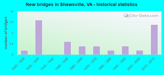
- New bridges - historical statistics
- 11920-1929
- 81930-1939
- 31950-1959
- 21960-1969
- 21970-1979
- 11980-1989
- 21990-1999
- 12000-2009
- 72010-2019

- Reconstructed bridges - Historical Statistics
- 11990-1999
- 12000-2009
- 02010-2019
- 12020-2022


- Bridge Condition - Deck
- 6.7%Excellent
- 60.0%Good
- 33.3%Satisfactory

- Bridge Condition - Superstructure
- 6.7%Excellent
- 6.7%Very good
- 46.7%Good
- 26.7%Satisfactory
- 13.3%Fair

- Bridge Condition - Substructure
- 6.7%Very good
- 53.3%Good
- 33.3%Satisfactory
- 6.7%Fair

- Bridge Condition - Channel
- 9.1%Very good
- 18.2%Good
- 45.5%Satisfactory
- 27.3%Fair

- Bridge Condition - Culverts
- 22.2%Good
- 55.6%Satisfactory
- 22.2%Fair
Find on map >> Show street view
Structure Number: 12109, Location: 5.25-RKE CO; 7.67-RT I 81 (Lat: 37.175975, Lng: -80.238150), Route carried "on" structure: US 11, Year Built: 1926, Status: Open, Structure Length: 4.39m (14.40ft), Average Daily Traffic: 3,206 (year 2020), Truck Traffic: 4%, Average Future Daily Traffic: 3,528 (year 2040), Design Load: H 15, Features Intersected: S FORK ROANOKE RIVER, Facility Carried by Structure: RKE RD & 460WBL
Minimum Vertical Clearance: 30+ m (98+ ft), Kilometerpoint: 207.131, Lanes on structure: 2, Owner: State Highway Agency, Approaching Roadway Width: 6.7m (22.0ft), Material/Design: Concrete, Design/Construction: Tee Beam, Number Of Spans In Main Unit: 3, Length of Maximum Span: 14.6m (47.9ft), Curb or Sidewalk Widths: Left: 0.2m (0.7ft), Right: 0.2m (0.7ft), Curb-To-Curb Width: 7.0m (23.0ft), Out-to-Out Width: 7.9m (25.9ft)
Condition: Deck: Satisfactory, Superstructure: Satisfactory, Substructure: Satisfactory, Channel: Satisfactory, Operating Rating: 44.5 metric tons, Method Used To Determine Operating Rating: Load and Resistance Factor (LRFR), Inventory Rating: 34.5 metric tons, Method Used To Determine Inventory Rating: Load and Resistance Factor (LRFR), Structural Evaluation: Equal to present minimum criteria, Deck Geometry: High priority of replacement, Waterway Adequacy: Equal to present desirable criteria, Approach Roadway Alignment: Equal to present minimum criteria, Length Of Structure Improvement: 5.18m (16.99ft), Designated Inspection Frequency: Every 24 months, Inspection Date: March 2021, Bridge Improvement Cost: $2,996,000, Roadway Improvement Cost: $1,046,000, Total Project Cost: $10,035,000 ( Estimate for 2019), Deck Structure Type: Concrete Cast-file-Place, Wearing Surface/Protective System: Wearing Surface: Epoxy Overlay
Find on map >> Show street view
Structure Number: 12117, Location: .35 Rte 637; 6.14 Rte 81 (Lat: 37.169347, Lng: -80.262119), Route carried "on" structure: US 11, Year Built: 1932, Status: Open, Structure Length: 1.34m (4.40ft), Average Daily Traffic: 5,916 (year 2020), Truck Traffic: 4%, Average Future Daily Traffic: 6,508 (year 2040), Features Intersected: Spring Branch
Minimum Vertical Clearance: 30+ m (98+ ft), Kilometerpoint: 204.668, Lanes on structure: 4, Owner: State Highway Agency, Approaching Roadway Width: 14.6m (47.9ft), Skew: 24 degrees, Material/Design: Concrete, Design/Construction: Culvert, Number Of Spans In Main Unit: 3, Length of Maximum Span: 3.0m (9.8ft)
Condition: Channel: Fair, Culverts: Fair, Operating Rating: 54.4 metric tons, Method Used To Determine Operating Rating: Field evaluation and documented engineering judgment, Inventory Rating: 32.7 metric tons, Method Used To Determine Inventory Rating: Field evaluation and documented engineering judgment, Structural Evaluation: Somewhat better than minimum adequacy, Waterway Adequacy: Equal to present minimum criteria, Approach Roadway Alignment: Equal to present desirable criteria, Length Of Structure Improvement: 1.83m (6.00ft), Designated Inspection Frequency: Every 24 months, Inspection Date: December 2020, Bridge Improvement Cost: $712,000, Roadway Improvement Cost: $249,000, Total Project Cost: $2,101,000 ( Estimate for 2015)
Find on map >> Show street view
Structure Number: 12123, Location: 5.39-ROANOKE C; 7.67-RT81 (Lat: 37.175642, Lng: -80.237906), Route carried "on" structure: US 11, Year Built: 1952, Year Reconstructed: 1998, Status: Open, Structure Length: 5.30m (17.39ft), Average Daily Traffic: 3,206 (year 2020), Truck Traffic: 4%, Average Future Daily Traffic: 3,528 (year 2040), Design Load: HS 20+Mod, Features Intersected: S FORK ROANOKE RIVER, Facility Carried by Structure: ROANOKE RD/EBL-460
Minimum Vertical Clearance: 30+ m (98+ ft), Kilometerpoint: 206.950, Lanes on structure: 2, Base Highway Network: Yes, Owner: State Highway Agency, Approaching Roadway Width: 7.3m (24.0ft), Skew: 3 degrees, Material/Design: Steel, Design/Construction: Stringer/Multi-beam, Number Of Spans In Main Unit: 3, Length of Maximum Span: 18.0m (59.1ft), Curb or Sidewalk Widths: Left: 0.5m (1.6ft), Right: 0.5m (1.6ft), Curb-To-Curb Width: 8.5m (27.9ft), Out-to-Out Width: 10.1m (33.1ft)
Condition: Deck: Satisfactory, Superstructure: Fair, Substructure: Fair, Channel: Fair, Operating Rating: 43.5 metric tons, Method Used To Determine Operating Rating: Load and Resistance Factor (LRFR), Inventory Rating: 33.6 metric tons, Method Used To Determine Inventory Rating: Load and Resistance Factor (LRFR), Structural Evaluation: Somewhat better than minimum adequacy, Deck Geometry: High priority of corrective action, Waterway Adequacy: Equal to present minimum criteria, Approach Roadway Alignment: Equal to present minimum criteria, Length Of Structure Improvement: 3.78m (12.40ft), Designated Inspection Frequency: Every 24 months, Inspection Date: March 2020, Bridge Improvement Cost: $3,617,000, Roadway Improvement Cost: $1,266,000, Total Project Cost: $12,115,000 ( Estimate for 2019), Deck Structure Type: Concrete Cast-file-Place, Wearing Surface/Protective System: Wearing Surface: Latex Concrete
Find on map >> Show street view
Structure Number: 12127, Location: 0.9 Rte 753; 0.4 Rte 636 (Lat: 37.168158, Lng: -80.284844), Route carried "on" structure: US 11, Year Built: 1932, Status: Open, Structure Length: 0.64m (2.10ft), Average Daily Traffic: 2,958 (year 2020), Truck Traffic: 4%, Average Future Daily Traffic: 3,828 (year 2040), Design Load: HS 20, Features Intersected: Spring Branch
Minimum Vertical Clearance: 30+ m (98+ ft), Kilometerpoint: 202.504, Lanes on structure: 2, Owner: State Highway Agency, Approaching Roadway Width: 7.3m (24.0ft), Material/Design: Concrete, Design/Construction: Culvert, Number Of Spans In Main Unit: 2, Length of Maximum Span: 3.0m (9.8ft)
Condition: Channel: Good, Culverts: Good, Operating Rating: 54.4 metric tons, Method Used To Determine Operating Rating: Field evaluation and documented engineering judgment, Inventory Rating: 32.7 metric tons, Method Used To Determine Inventory Rating: Field evaluation and documented engineering judgment, Structural Evaluation: Better than present minimum criteria, Waterway Adequacy: Meets minimum limits, Approach Roadway Alignment: Equal to present desirable criteria, Length Of Structure Improvement: 0.64m (2.10ft), Designated Inspection Frequency: Every 24 months, Inspection Date: Febuary 2021, Bridge Improvement Cost: $52,000, Roadway Improvement Cost: $5,000, Total Project Cost: $78,000
Find on map >> Show street view
Structure Number: 12128, Location: 0.02 Rt 636; 4.33 Rt 81. (Lat: 37.165117, Lng: -80.292178), Route carried "on" structure: US 11, Year Built: 1932, Status: Open, Structure Length: 0.64m (2.10ft), Average Daily Traffic: 2,958 (year 2020), Truck Traffic: 4%, Average Future Daily Traffic: 3,828 (year 2040), Design Load: HS 20, Features Intersected: Spring Branch
Minimum Vertical Clearance: 30+ m (98+ ft), Kilometerpoint: 201.764, Lanes on structure: 2, Owner: State Highway Agency, Approaching Roadway Width: 7.3m (24.0ft), Material/Design: Concrete, Design/Construction: Culvert, Number Of Spans In Main Unit: 2, Length of Maximum Span: 3.0m (9.8ft)
Condition: Channel: Fair, Culverts: Satisfactory, Operating Rating: 54.4 metric tons, Method Used To Determine Operating Rating: Field evaluation and documented engineering judgment, Inventory Rating: 32.7 metric tons, Method Used To Determine Inventory Rating: Field evaluation and documented engineering judgment, Structural Evaluation: Equal to present minimum criteria, Waterway Adequacy: High priority of corrective action, Approach Roadway Alignment: Equal to present desirable criteria, Length Of Structure Improvement: 0.64m (2.10ft), Designated Inspection Frequency: Every 24 months, Inspection Date: December 2020, Bridge Improvement Cost: $189,000, Roadway Improvement Cost: $66,000, Total Project Cost: $557,000 ( Estimate for 2018)
Find on map >> Show street view
Structure Number: 12129, Location: .02-Rte636; 1.0 Rte641 (Lat: 37.164900, Lng: -80.292500), Route carried "on" structure: US 11, Year Built: 1932, Year Reconstructed: 2020, Status: Open, Structure Length: 0.64m (2.10ft), Average Daily Traffic: 2,958 (year 2020), Truck Traffic: 4%, Average Future Daily Traffic: 3,828 (year 2040), Design Load: HL 93, Features Intersected: Spring Branch
Minimum Vertical Clearance: 30+ m (98+ ft), Kilometerpoint: 201.762, Lanes on structure: 2, Owner: State Highway Agency, Approaching Roadway Width: 8.8m (28.9ft), Material/Design: Concrete, Design/Construction: Slab, Number Of Spans In Main Unit: 1, Length of Maximum Span: 6.4m (21.0ft), Curb or Sidewalk Widths: Left: 0.4m (1.3ft), Right: 0.4m (1.3ft), Curb-To-Curb Width: 8.8m (28.9ft), Out-to-Out Width: 9.5m (31.2ft)
Condition: Deck: Excellent, Superstructure: Excellent, Substructure: Good, Channel: Good, Operating Rating: 89.8 metric tons, Method Used To Determine Operating Rating: Load and Resistance Factor (LRFR), Inventory Rating: 71.7 metric tons, Method Used To Determine Inventory Rating: Load and Resistance Factor (LRFR), Structural Evaluation: Better than present minimum criteria, Deck Geometry: High priority of corrective action, Waterway Adequacy: High priority of corrective action, Approach Roadway Alignment: Equal to present desirable criteria, Length Of Structure Improvement: 0.67m (2.20ft), Designated Inspection Frequency: Every 24 months, Inspection Date: December 2020, Bridge Improvement Cost: $400,000, Roadway Improvement Cost: $120,000, Total Project Cost: $1,280,000 ( Estimate for 2019), Deck Structure Type: Concrete Precast Panels, Wearing Surface/Protective System: Wearing Surface: Bituminous, Membrane: Other, Deck Protection: Other
Find on map >> Show street view
Structure Number: 12202, Location: .80-Rte11; 1.40-Rte634 (Lat: 37.166444, Lng: -80.237972), Route carried "on" structure: County highway 609, Year Built: 1956, Status: Open, Structure Length: 0.85m (2.79ft), Average Daily Traffic: 176 (year 2019), Average Future Daily Traffic: 250 (year 2040), Features Intersected: Spring Branch
Minimum Vertical Clearance: 30+ m (98+ ft), Kilometerpoint: 17.723, Lanes on structure: 2, Owner: State Highway Agency, Approaching Roadway Width: 4.9m (16.1ft), Skew: 1 degrees, Material/Design: Steel, Design/Construction: Stringer/Multi-beam, Number Of Spans In Main Unit: 1, Length of Maximum Span: 8.5m (27.9ft), Curb or Sidewalk Widths: Left: 0.3m (1.0ft), Right: 0.3m (1.0ft), Curb-To-Curb Width: 6.1m (20.0ft), Out-to-Out Width: 7.0m (23.0ft)
Condition: Deck: Satisfactory, Superstructure: Satisfactory, Substructure: Satisfactory, Channel: Fair, Operating Rating: 59.0 metric tons, Method Used To Determine Operating Rating: Load and Resistance Factor (LRFR), Inventory Rating: 45.4 metric tons, Method Used To Determine Inventory Rating: Load and Resistance Factor (LRFR), Structural Evaluation: Equal to present minimum criteria, Deck Geometry: Meets minimum limits, Waterway Adequacy: Equal to present minimum criteria, Approach Roadway Alignment: Equal to present minimum criteria, Length Of Structure Improvement: 1.52m (4.99ft), Designated Inspection Frequency: Every 24 months, Inspection Date: August 2020, Bridge Improvement Cost: $262,000, Roadway Improvement Cost: $92,000, Total Project Cost: $852,000 ( Estimate for 2018), Deck Structure Type: Concrete Cast-file-Place, Wearing Surface/Protective System: Wearing Surface: Epoxy Overlay
Find on map >> Show street view
Structure Number: 12203, Location: 1.20-Rt11; 1.00-Rt634 (Lat: 37.162578, Lng: -80.241731), Route carried "on" structure: State highway 609, Year Built: 1932, Year Reconstructed: 2012, Status: Open, Structure Length: 3.03m (9.94ft), Average Daily Traffic: 176 (year 2019), Average Future Daily Traffic: 250 (year 2040), Design Load: HL 93, Features Intersected: S. FORK ROANOKE RIVER
Minimum Vertical Clearance: 30+ m (98+ ft), Kilometerpoint: 17.057, Lanes on structure: 1, Owner: State Highway Agency, Approaching Roadway Width: 5.0m (16.4ft), Material/Design: Steel, Design/Construction: Stringer/Multi-beam, Number Of Spans In Main Unit: 3, Length of Maximum Span: 12.4m (40.7ft), Curb or Sidewalk Widths: Left: 0.3m (1.0ft), Right: 0.3m (1.0ft), Curb-To-Curb Width: 3.4m (11.2ft), Out-to-Out Width: 4.1m (13.5ft)
Condition: Deck: Good, Superstructure: Good, Substructure: Good, Channel: Satisfactory, Operating Rating: 70.8 metric tons, Method Used To Determine Operating Rating: Load and Resistance Factor (LRFR), Inventory Rating: 54.4 metric tons, Method Used To Determine Inventory Rating: Load and Resistance Factor (LRFR), Structural Evaluation: Better than present minimum criteria, Deck Geometry: High priority of replacement, Waterway Adequacy: Equal to present minimum criteria, Approach Roadway Alignment: High priority of corrective action, Length Of Structure Improvement: 3.05m (10.01ft), Designated Inspection Frequency: Every 24 months, Inspection Date: October 2020, Bridge Improvement Cost: $576,000, Roadway Improvement Cost: $202,000, Total Project Cost: $1,873,000 ( Estimate for 2016), Deck Structure Type: Wood or Timber, Wearing Surface/Protective System: Wearing Surface: Bituminous, Membrane: Other
Find on map >> Show street view
Structure Number: 12204, Location: 0.20-Rt637; 6.00-Floyd Co (Lat: 37.108225, Lng: -80.257042), Route carried "on" structure: County highway 609, Year Built: 1985, Status: Open, Structure Length: 2.56m (8.40ft), Average Daily Traffic: 90 (year 2020), Average Future Daily Traffic: 126 (year 2040), Design Load: HS 20, Features Intersected: South Fork Roanoke RIver
Minimum Vertical Clearance: 30+ m (98+ ft), Kilometerpoint: 9.646, Lanes on structure: 2, Owner: State Highway Agency, Approaching Roadway Width: 4.3m (14.1ft), Skew: 3 degrees, Material/Design: Concrete continuous, Design/Construction: Slab, Number Of Spans In Main Unit: 2, Length of Maximum Span: 12.8m (42.0ft), Curb-To-Curb Width: 7.3m (24.0ft), Out-to-Out Width: 8.1m (26.6ft)
Condition: Deck: Good, Superstructure: Good, Substructure: Good, Channel: Satisfactory, Operating Rating: 87.1 metric tons, Method Used To Determine Operating Rating: Load and Resistance Factor (LRFR), Inventory Rating: 67.1 metric tons, Method Used To Determine Inventory Rating: Load and Resistance Factor (LRFR), Structural Evaluation: Better than present minimum criteria, Deck Geometry: Equal to present minimum criteria, Waterway Adequacy: Meets minimum limits, Approach Roadway Alignment: Equal to present desirable criteria, Length Of Structure Improvement: 2.56m (8.40ft), Designated Inspection Frequency: Every 24 months, Inspection Date: August 2021, Bridge Improvement Cost: $825,000, Roadway Improvement Cost: $83,000, Total Project Cost: $1,238,000, Deck Structure Type: Concrete Cast-file-Place, Wearing Surface/Protective System: Deck Protection: Epoxy Coated Reinforcing
Find on map >> Show street view
Structure Number: 12248, Location: 2.40-RT690; 0.40-RT638 (Lat: 37.141583, Lng: -80.265719), Route carried "on" structure: County highway 637, Year Built: 1975, Status: Open, Structure Length: 3.81m (12.50ft), Average Daily Traffic: 1,303 (year 2020), Truck Traffic: 1%, Average Future Daily Traffic: 1,433 (year 2040), Features Intersected: S FORK ROANOKE RIVER
Minimum Vertical Clearance: 30+ m (98+ ft), Kilometerpoint: 4.280, Lanes on structure: 2, Owner: State Highway Agency, Approaching Roadway Width: 6.7m (22.0ft), Material/Design: Steel, Design/Construction: Stringer/Multi-beam, Number Of Spans In Main Unit: 3, Length of Maximum Span: 12.8m (42.0ft), Curb-To-Curb Width: 9.8m (32.2ft), Out-to-Out Width: 11.0m (36.1ft)
Condition: Deck: Good, Superstructure: Satisfactory, Substructure: Good, Channel: Satisfactory, Operating Rating: 62.6 metric tons, Method Used To Determine Operating Rating: Load and Resistance Factor (LRFR), Inventory Rating: 48.1 metric tons, Method Used To Determine Inventory Rating: Load and Resistance Factor (LRFR), Structural Evaluation: Equal to present minimum criteria, Deck Geometry: Somewhat better than minimum adequacy, Waterway Adequacy: Better than present minimum criteria, Approach Roadway Alignment: Equal to present desirable criteria, Designated Inspection Frequency: Every 24 months, Inspection Date: December 2021, Deck Structure Type: Concrete Cast-file-Place, Wearing Surface/Protective System: Wearing Surface: Epoxy Overlay
Find on map >> Show street view
Structure Number: 12252, Location: .14-Rte 11; .02-Rte 690 (Lat: 37.166408, Lng: -80.254514), Route carried "on" structure: County highway 637, Year Built: 1962, Status: Open, Structure Length: 0.70m (2.30ft), Average Daily Traffic: 1,808 (year 2020), Truck Traffic: 3%, Average Future Daily Traffic: 1,989 (year 2040), Design Load: HS 20, Features Intersected: Spring Branch
Minimum Vertical Clearance: 30+ m (98+ ft), Kilometerpoint: 0.386, Lanes on structure: 2, Owner: State Highway Agency, Approaching Roadway Width: 6.7m (22.0ft), Skew: 4 degrees, Material/Design: Concrete, Design/Construction: Culvert, Number Of Spans In Main Unit: 2, Length of Maximum Span: 2.4m (7.9ft)
Condition: Channel: Satisfactory, Culverts: Satisfactory, Operating Rating: 54.4 metric tons, Method Used To Determine Operating Rating: Field evaluation and documented engineering judgment, Inventory Rating: 32.7 metric tons, Method Used To Determine Inventory Rating: Field evaluation and documented engineering judgment, Structural Evaluation: Equal to present minimum criteria, Waterway Adequacy: Better than present minimum criteria, Approach Roadway Alignment: Equal to present desirable criteria, Designated Inspection Frequency: Every 24 months, Inspection Date: January 2021
Find on map >> Show street view
Structure Number: 12253, Location: .40-Rte 639; .10-Rte 757 (Lat: 37.129414, Lng: -80.264883), Route carried "on" structure: County highway 637, Year Built: 1932, Status: Open, Structure Length: 0.64m (2.10ft), Average Daily Traffic: 1,303 (year 2020), Truck Traffic: 3%, Average Future Daily Traffic: 1,433 (year 2040), Features Intersected: Calhoun Run
Minimum Vertical Clearance: 30+ m (98+ ft), Kilometerpoint: 5.760, Lanes on structure: 2, Owner: State Highway Agency, Approaching Roadway Width: 6.4m (21.0ft), Material/Design: Steel, Design/Construction: Culvert, Number Of Spans In Main Unit: 2, Length of Maximum Span: 2.7m (8.9ft)
Condition: Channel: Satisfactory, Culverts: Satisfactory, Operating Rating: 89.8 metric tons, Method Used To Determine Operating Rating: Load Factor (LF), Inventory Rating: 88.9 metric tons, Method Used To Determine Inventory Rating: Load Factor (LF), Structural Evaluation: Equal to present minimum criteria, Waterway Adequacy: Somewhat better than minimum adequacy, Approach Roadway Alignment: Equal to present desirable criteria, Designated Inspection Frequency: Every 24 months, Inspection Date: January 2021
Find on map >> Show street view
Structure Number: 12259, Location: 0.00-Rt637; 2.00-Rt722 (Lat: 37.123872, Lng: -80.268281), Route carried "on" structure: County highway 639, Year Built: 1932, Status: Open, Structure Length: 2.30m (7.55ft), Average Daily Traffic: 326 (year 2020), Average Future Daily Traffic: 359 (year 2040), Features Intersected: S. Fork Roanoke River
Minimum Vertical Clearance: 30+ m (98+ ft), Kilometerpoint: 7.685, Lanes on structure: 2, Owner: State Highway Agency, Approaching Roadway Width: 4.9m (16.1ft), Material/Design: Steel, Design/Construction: Stringer/Multi-beam, Number Of Spans In Main Unit: 2, Length of Maximum Span: 14.5m (47.6ft), Curb or Sidewalk Widths: Left: 0.3m (1.0ft), Right: 0.3m (1.0ft), Curb-To-Curb Width: 6.1m (20.0ft), Out-to-Out Width: 6.8m (22.3ft)
Condition: Deck: Good, Superstructure: Good, Substructure: Satisfactory, Channel: Satisfactory, Operating Rating: 43.5 metric tons, Method Used To Determine Operating Rating: Load and Resistance Factor (LRFR), Inventory Rating: 33.6 metric tons, Method Used To Determine Inventory Rating: Load and Resistance Factor (LRFR), Structural Evaluation: Equal to present minimum criteria, Deck Geometry: Meets minimum limits, Waterway Adequacy: Equal to present desirable criteria, Approach Roadway Alignment: Equal to present desirable criteria, Length Of Structure Improvement: 2.29m (7.51ft), Designated Inspection Frequency: Every 24 months, Inspection Date: August 2021, Bridge Improvement Cost: $738,000, Roadway Improvement Cost: $74,000, Total Project Cost: $1,107,000, Deck Structure Type: Concrete Cast-file-Place, Wearing Surface/Protective System: Wearing Surface: Epoxy Overlay
Find on map >> Show street view
Structure Number: 12337, Location: 0.00 Rt 11; 0.14 Rt 822 (Lat: 37.171844, Lng: -80.268139), Route carried "on" structure: County highway 753, Year Built: 1932, Status: Open, Structure Length: 1.34m (4.40ft), Average Daily Traffic: 374 (year 2020), Truck Traffic: 2%, Average Future Daily Traffic: 400 (year 2040), Features Intersected: Spring Branch
Minimum Vertical Clearance: 30+ m (98+ ft), Kilometerpoint: 0.016, Lanes on structure: 2, Owner: State Highway Agency, Approaching Roadway Width: 5.5m (18.0ft), Skew: 3 degrees, Material/Design: Concrete, Design/Construction: Culvert, Number Of Spans In Main Unit: 3, Length of Maximum Span: 3.0m (9.8ft)
Condition: Channel: Satisfactory, Culverts: Satisfactory, Operating Rating: 54.4 metric tons, Method Used To Determine Operating Rating: Field evaluation and documented engineering judgment, Inventory Rating: 32.7 metric tons, Method Used To Determine Inventory Rating: Field evaluation and documented engineering judgment, Structural Evaluation: Equal to present minimum criteria, Waterway Adequacy: Somewhat better than minimum adequacy, Approach Roadway Alignment: Equal to present desirable criteria, Designated Inspection Frequency: Every 24 months, Inspection Date: Febuary 2021
Find on map >> Show street view
Structure Number: 12365, Location: 0.30-RT603; 1.40-RT636 (Lat: 37.202456, Lng: -80.297264), Route carried "on" structure: County highway 821, Year Built: 1990, Status: Open, Structure Length: 4.65m (15.26ft), Average Daily Traffic: 405 (year 2013), Average Future Daily Traffic: 624 (year 2040), Features Intersected: N Fork Roanoke River, Facility Carried by Structure: Seneca Hollow Rd
Minimum Vertical Clearance: 30+ m (98+ ft), Kilometerpoint: 2.288, Lanes on structure: 2, Owner: State Highway Agency, Approaching Roadway Width: 6.1m (20.0ft), Skew: 3 degrees, Material/Design: Steel, Design/Construction: Stringer/Multi-beam, Number Of Spans In Main Unit: 2, Length of Maximum Span: 23.2m (76.1ft), Curb-To-Curb Width: 6.9m (22.6ft), Out-to-Out Width: 7.9m (25.9ft)
Condition: Deck: Good, Superstructure: Good, Substructure: Good, Channel: Satisfactory, Operating Rating: 69.9 metric tons, Method Used To Determine Operating Rating: Load and Resistance Factor (LRFR), Inventory Rating: 53.5 metric tons, Method Used To Determine Inventory Rating: Load and Resistance Factor (LRFR), Structural Evaluation: Better than present minimum criteria, Deck Geometry: Meets minimum limits, Waterway Adequacy: Equal to present minimum criteria, Approach Roadway Alignment: Equal to present minimum criteria, Length Of Structure Improvement: 4.69m (15.39ft), Designated Inspection Frequency: Every 24 months, Inspection Date: March 2022, Bridge Improvement Cost: $2,000, Roadway Improvement Cost: $1,000, Total Project Cost: $7,000 ( Estimate for 2022), Deck Structure Type: Concrete Cast-file-Place, Wearing Surface/Protective System: Deck Protection: Epoxy Coated Reinforcing
Find on map >> Show street view
Structure Number: 19686, Location: .05M TO 602& 1.15M TO 646 (Lat: 36.828236, Lng: -81.099467), Route carried "on" structure: County highway 619, Year Built: 1962, Status: Open, Structure Length: 7.32m (24.02ft), Average Daily Traffic: 162 (year 2020), Truck Traffic: 3%, Average Future Daily Traffic: 227 (year 2040), Design Load: HS 20, Features Intersected: CRIPPLE CREEK, Facility Carried by Structure: GLEAVES RD.
Minimum Vertical Clearance: 30+ m (98+ ft), Kilometerpoint: 7.723, Lanes on structure: 2, Owner: State Highway Agency, Approaching Roadway Width: 5.8m (19.0ft), Skew: 2 degrees, Material/Design: Concrete, Design/Construction: Tee Beam, Number Of Spans In Main Unit: 5, Length of Maximum Span: 14.9m (48.9ft), Curb or Sidewalk Widths: Left: 0.5m (1.6ft), Right: 0.5m (1.6ft), Curb-To-Curb Width: 7.3m (24.0ft), Out-to-Out Width: 8.8m (28.9ft)
Condition: Deck: Satisfactory, Superstructure: Fair, Substructure: Satisfactory, Channel: Fair, Operating Rating: 49.0 metric tons, Method Used To Determine Operating Rating: Load and Resistance Factor (LRFR), Inventory Rating: 37.2 metric tons, Method Used To Determine Inventory Rating: Load and Resistance Factor (LRFR), Structural Evaluation: Somewhat better than minimum adequacy, Deck Geometry: Somewhat better than minimum adequacy, Waterway Adequacy: Better than present minimum criteria, Approach Roadway Alignment: Better than present minimum criteria, Designated Inspection Frequency: Every 24 months, Inspection Date: May 2020, Deck Structure Type: Concrete Cast-file-Place, Wearing Surface/Protective System: Wearing Surface: Latex Concrete
Find on map >> Show street view
Structure Number: 19689, Location: .0M TO 631 & 1.0M TO 634 (Lat: 36.859106, Lng: -80.929039), Route carried "on" structure: County highway 619, Year Built: 1959, Status: Open, Structure Length: 1.37m (4.49ft), Average Daily Traffic: 471 (year 2020), Truck Traffic: 5%, Average Future Daily Traffic: 518 (year 2040), Design Load: H 20, Features Intersected: MILL CREEK, Facility Carried by Structure: AUSTINVILLE RD.
Minimum Vertical Clearance: 30+ m (98+ ft), Kilometerpoint: 25.390, Lanes on structure: 2, Owner: State Highway Agency, Approaching Roadway Width: 6.1m (20.0ft), Skew: 4 degrees, Material/Design: Concrete, Design/Construction: Culvert, Number Of Spans In Main Unit: 3, Length of Maximum Span: 4.3m (14.1ft)
Condition: Channel: Satisfactory, Culverts: Satisfactory, Operating Rating: 44.5 metric tons, Method Used To Determine Operating Rating: Field evaluation and documented engineering judgment, Inventory Rating: 32.7 metric tons, Method Used To Determine Inventory Rating: Field evaluation and documented engineering judgment, Structural Evaluation: Equal to present minimum criteria, Waterway Adequacy: Better than present minimum criteria, Approach Roadway Alignment: Better than present minimum criteria, Designated Inspection Frequency: Every 24 months, Inspection Date: April 2021
Find on map >> Show street view
Structure Number: 19856, Location: 0.00 Mi To Hampton City (Lat: 37.095889, Lng: -76.400397), Route carried "on" structure: State highway 134, Year Built: 1973, Status: Open, Structure Length: 2.93m (9.61ft), Average Daily Traffic: 9,621 (year 2020), Truck Traffic: 1%, Average Future Daily Traffic: 13,469 (year 2040), Design Load: HS 20+Mod, Features Intersected: Brick Kiln Creek, Facility Carried by Structure: Magruder Blvd SBL
Minimum Vertical Clearance: 30+ m (98+ ft), Kilometerpoint: 6.545, Lanes on structure: 2, Base Highway Network: Yes, Owner: State Highway Agency, Approaching Roadway Width: 7.9m (25.9ft), Material/Design: Concrete, Design/Construction: Slab, Number Of Spans In Main Unit: 3, Length of Maximum Span: 9.8m (32.2ft), Curb-To-Curb Width: 11.6m (38.1ft), Out-to-Out Width: 12.8m (42.0ft)
Condition: Deck: Satisfactory, Superstructure: Satisfactory, Substructure: Satisfactory, Channel: Very good, Operating Rating: 38.0 metric tons, Method Used To Determine Operating Rating: Load and Resistance Factor (LRFR), Inventory Rating: 29.3 metric tons, Method Used To Determine Inventory Rating: Load and Resistance Factor (LRFR), Structural Evaluation: Equal to present minimum criteria, Deck Geometry: Better than present minimum criteria, Waterway Adequacy: Better than present minimum criteria, Approach Roadway Alignment: Equal to present desirable criteria, Designated Inspection Frequency: Every 24 months, Underwater Inspection Frequency: Every 60 months, Inspection Date: December 2021, Underwater Inspection Date: November 2020, Deck Structure Type: Concrete Cast-file-Place, Wearing Surface/Protective System: Wearing Surface: Epoxy Overlay, Membrane: Epoxy
Find on map >> Show street view
Structure Number: 23553, Location: 0.00 End Mnt; 0.10 Rt 637 (Lat: 37.116769, Lng: -80.267489), Route carried "on" structure: County highway 755, Year Built: 1992, Status: Open, Structure Length: 2.74m (8.99ft), Average Daily Traffic: 36 (year 2020), Average Future Daily Traffic: 50 (year 2040), Design Load: HS 20, Features Intersected: South Fork Roa River
Minimum Vertical Clearance: 30+ m (98+ ft), Kilometerpoint: 0.000, Lanes on structure: 1, Owner: State Highway Agency, Approaching Roadway Width: 4.3m (14.1ft), Material/Design: Concrete, Design/Construction: Culvert, Number Of Spans In Main Unit: 16, Length of Maximum Span: 0.9m (3.0ft), Curb-To-Curb Width: 4.9m (16.1ft), Out-to-Out Width: 4.9m (16.1ft)
Condition: Channel: Fair, Culverts: Fair, Operating Rating: 32.7 metric tons, Method Used To Determine Operating Rating: Field evaluation and documented engineering judgment, Inventory Rating: 32.7 metric tons, Method Used To Determine Inventory Rating: Field evaluation and documented engineering judgment, Structural Evaluation: Somewhat better than minimum adequacy, Deck Geometry: High priority of corrective action, Waterway Adequacy: High priority of corrective action, Approach Roadway Alignment: Equal to present minimum criteria, Length Of Structure Improvement: 2.74m (8.99ft), Designated Inspection Frequency: Every 24 months, Inspection Date: August 2020, Bridge Improvement Cost: $730,000, Roadway Improvement Cost: $109,000, Total Project Cost: $2,153,000 ( Estimate for 2018)
Find on map >> Show street view
Structure Number: 26089, Location: 3.50-RT639; .0-RT637 (Lat: 37.136517, Lng: -80.267967), Route carried "on" structure: County highway 638, Year Built: 2003, Status: Open, Structure Length: 3.35m (10.99ft), Average Daily Traffic: 144 (year 2020), Average Future Daily Traffic: 202 (year 2040), Features Intersected: S Fork Roanoke River
Minimum Vertical Clearance: 30+ m (98+ ft), Kilometerpoint: 0.016, Lanes on structure: 2, Owner: State Highway Agency, Approaching Roadway Width: 6.1m (20.0ft), Material/Design: Concrete, Design/Construction: Slab, Number Of Spans In Main Unit: 3, Length of Maximum Span: 12.8m (42.0ft), Curb or Sidewalk Widths: Left: 0.3m (1.0ft), Right: 0.3m (1.0ft), Curb-To-Curb Width: 6.7m (22.0ft), Out-to-Out Width: 7.5m (24.6ft)
Condition: Deck: Good, Superstructure: Good, Substructure: Very good, Channel: Good, Operating Rating: 58.1 metric tons, Method Used To Determine Operating Rating: Load and Resistance Factor (LRFR), Inventory Rating: 44.5 metric tons, Method Used To Determine Inventory Rating: Load and Resistance Factor (LRFR), Structural Evaluation: Better than present minimum criteria, Deck Geometry: Meets minimum limits, Waterway Adequacy: Equal to present minimum criteria, Approach Roadway Alignment: Equal to present desirable criteria, Length Of Structure Improvement: 3.35m (10.99ft), Designated Inspection Frequency: Every 24 months, Inspection Date: October 2021, Bridge Improvement Cost: $1,033,000, Roadway Improvement Cost: $362,000, Total Project Cost: $3,357,000 ( Estimate for 2017), Deck Structure Type: Concrete Cast-file-Place
Find on map >> Show street view
Structure Number: 29484, Location: 0.03 Route 11/.10 End SM (Lat: 37.198594, Lng: -80.285172), Route carried "on" structure: Spur County highway 9257, Year Built: 2010, Status: Open, Structure Length: 0.73m (2.40ft), Average Daily Traffic: 759 (year 2020), Average Future Daily Traffic: 835 (year 2040), Design Load: HS 20+Mod, Features Intersected: Br S.F. Roanoke River
Minimum Vertical Clearance: 30.18m (99.02ft), Kilometerpoint: 0.000, Lanes on structure: 2, Base Highway Network: Yes, Owner: State Highway Agency, Approaching Roadway Width: 7.3m (24.0ft), Material/Design: Concrete, Design/Construction: Culvert, Number Of Spans In Main Unit: 3, Length of Maximum Span: 1.8m (5.9ft)
Condition: Channel: Good, Culverts: Good, Operating Rating: 89.8 metric tons, Method Used To Determine Operating Rating: Load Factor (LF), Inventory Rating: 89.8 metric tons, Method Used To Determine Inventory Rating: Load Factor (LF), Structural Evaluation: Better than present minimum criteria, Waterway Adequacy: Equal to present desirable criteria, Approach Roadway Alignment: Equal to present desirable criteria, Designated Inspection Frequency: Every 24 months, Inspection Date: October 2020
Find on map >> Show street view
Structure Number: 29535, Location: 1.15-Rt 11;0.15-Rt820 (Lat: 37.174750, Lng: -80.300833), Route carried "on" structure: Alternate County highway 636, Year Built: 2012, Status: Open, Structure Length: 6.53m (21.42ft), Average Daily Traffic: 280 (year 2020), Average Future Daily Traffic: 392 (year 2040), Design Load: HL 93, Features Intersected: Rte. I 81
Minimum Vertical Clearance: 30+ m (98+ ft), Kilometerpoint: 1.674, Lanes on structure: 2, Lanes under structure: 5, Owner: State Highway Agency, Approaching Roadway Width: 7.3m (24.0ft), Material/Design: Prestressed concrete, Design/Construction: Stringer/Multi-beam, Number Of Spans In Main Unit: 2, Length of Maximum Span: 32.6m (107.0ft), Curb-To-Curb Width: 7.9m (25.9ft), Out-to-Out Width: 8.9m (29.2ft)
Condition: Deck: Good, Superstructure: Good, Substructure: Good, Operating Rating: 89.8 metric tons, Method Used To Determine Operating Rating: Load and Resistance Factor (LRFR), Inventory Rating: 51.7 metric tons, Method Used To Determine Inventory Rating: Load and Resistance Factor (LRFR), Structural Evaluation: Better than present minimum criteria, Deck Geometry: Somewhat better than minimum adequacy, Underclear: Equal to present minimum criteria, Approach Roadway Alignment: Equal to present minimum criteria, Designated Inspection Frequency: Every 24 months, Inspection Date: April 2021, Deck Structure Type: Concrete Cast-file-Place, Wearing Surface/Protective System: Deck Protection: Other Coated Reinforcing
Find on map >> Show street view
Structure Number: 29536, Location: 0.75-Rt 821;2.0-Rt 11&460 (Lat: 37.196139, Lng: -80.269833), Route carried "on" structure: County highway 636, Year Built: 2012, Status: Open, Structure Length: 6.62m (21.72ft), Average Daily Traffic: 430 (year 2020), Average Future Daily Traffic: 473 (year 2040), Design Load: HL 93, Features Intersected: Rte. I-81
Minimum Vertical Clearance: 30+ m (98+ ft), Kilometerpoint: 6.162, Lanes on structure: 2, Lanes under structure: 5, Owner: State Highway Agency, Approaching Roadway Width: 8.1m (26.6ft), Skew: 1 degrees, Material/Design: Prestressed concrete continuous, Design/Construction: Stringer/Multi-beam, Number Of Spans In Main Unit: 2, Length of Maximum Span: 33.1m (108.6ft), Curb-To-Curb Width: 7.9m (25.9ft), Out-to-Out Width: 8.9m (29.2ft)
Condition: Deck: Good, Superstructure: Good, Substructure: Good, Operating Rating: 89.8 metric tons, Method Used To Determine Operating Rating: Load and Resistance Factor (LRFR), Inventory Rating: 51.7 metric tons, Method Used To Determine Inventory Rating: Load and Resistance Factor (LRFR), Structural Evaluation: Better than present minimum criteria, Deck Geometry: Somewhat better than minimum adequacy, Underclear: Better than present minimum criteria, Approach Roadway Alignment: Equal to present minimum criteria, Designated Inspection Frequency: Every 24 months, Inspection Date: April 2021, Deck Structure Type: Concrete Cast-file-Place, Wearing Surface/Protective System: Deck Protection: Epoxy Coated Reinforcing
Find on map >> Show street view
Structure Number: 29558, Location: 0.60 Rte 637;1.45 Rte 722 (Lat: 37.119308, Lng: -80.276125), Route carried "on" structure: County highway 639, Year Built: 2019, Status: Open, Structure Length: 3.40m (11.15ft), Average Daily Traffic: 326 (year 2020), Average Future Daily Traffic: 359 (year 2040), Design Load: HL 93, Features Intersected: Elliot Creek
Minimum Vertical Clearance: 30+ m (98+ ft), Kilometerpoint: 6.727, Lanes on structure: 2, Owner: State Highway Agency, Approaching Roadway Width: 7.9m (25.9ft), Skew: 3 degrees, Material/Design: Concrete continuous, Design/Construction: Stringer/Multi-beam, Number Of Spans In Main Unit: 2, Length of Maximum Span: 18.4m (60.4ft), Curb or Sidewalk Widths: Left: 0.5m (1.6ft), Right: 0.5m (1.6ft), Curb-To-Curb Width: 6.6m (21.7ft), Out-to-Out Width: 7.6m (24.9ft)
Condition: Deck: Good, Superstructure: Very good, Substructure: Good, Channel: Very good, Operating Rating: 68.0 metric tons, Method Used To Determine Operating Rating: Load and Resistance Factor (LRFR), Inventory Rating: 52.6 metric tons, Method Used To Determine Inventory Rating: Load and Resistance Factor (LRFR), Structural Evaluation: Better than present minimum criteria, Deck Geometry: Meets minimum limits, Waterway Adequacy: Equal to present desirable criteria, Approach Roadway Alignment: Meets minimum limits, Length Of Structure Improvement: 3.44m (11.29ft), Designated Inspection Frequency: Every 24 months, Inspection Date: December 2021, Bridge Improvement Cost: $1,000, Roadway Improvement Cost: $1,000, Total Project Cost: $3,000 ( Estimate for 2019), Deck Structure Type: Concrete Cast-file-Place, Wearing Surface/Protective System: Deck Protection: Galvanized Reinforcing
Find on map >> Show street view
Structure Number: 29535, Location: 1.15-Rt 11;0.15-Rt820 (Lat: 37.174750, Lng: -80.300833), Route carried "under" structure: Alternate County highway 81, Year Built: 2012, Structure Length: 0. m, Average Daily Traffic: 53,000 (year 2019), Truck Traffic: 26%, Features Intersected: Rte. I 81, Facility Carried by Structure: Friendship Rd.636
Minimum Vertical Clearance: 7.57m (24.84ft), Kilometerpoint: 28.624, Lanes on structure: 2, Lanes under structure: 5, Material/Design: Prestressed concrete, Design/Construction: Stringer/Multi-beam, Length of Maximum Span: 32.6m (107.0ft)
Find on map >> Show street view
Structure Number: 29536, Location: 0.75-Rt 821;2.0-Rt 11&460 (Lat: 37.196139, Lng: -80.269833), Route carried "under" structure: Interstate 81, Year Built: 2012, Structure Length: 0. m, Average Daily Traffic: 53,000 (year 2019), Truck Traffic: 26%, Features Intersected: Rte. I-81, Facility Carried by Structure: Rte. 636
Minimum Vertical Clearance: 7.16m (23.49ft), Kilometerpoint: 32.406, Lanes on structure: 2, Lanes under structure: 2, Material/Design: Prestressed concrete continuous, Design/Construction: Stringer/Multi-beam, Length of Maximum Span: 33.1m (108.6ft)
Find on map >> Show street view
Structure Number: 29536, Location: 0.75-Rt 821;2.0-Rt 11&460 (Lat: 37.196139, Lng: -80.269833), Route carried "under" structure: Interstate 81, Year Built: 2012, Structure Length: 0. m, Average Daily Traffic: 24,050 (year 1994), Truck Traffic: 10%, Features Intersected: Rte. I-81, Facility Carried by Structure: Rte. 636
Minimum Vertical Clearance: 6.98m (22.90ft), Kilometerpoint: 32.406, Lanes on structure: 2, Lanes under structure: 3, Material/Design: Prestressed concrete continuous, Design/Construction: Stringer/Multi-beam, Length of Maximum Span: 33.1m (108.6ft)