Bridge Statistics for Shenandoah, Iowa (IA)
Condition, Traffic, Stress, Structural Evaluation, Project Costs
- National Bridge Inventory (NBI) Statistics
- 15Number of bridges
- 174ft / 52.6mTotal length
- 11,435Total average daily traffic
- 966Total average daily truck traffic
- 11,435Total future (year 2038) average daily traffic
- National Bridge Inventory (NBI) Registered Bridges for Shenandoah
- No street view available for this location
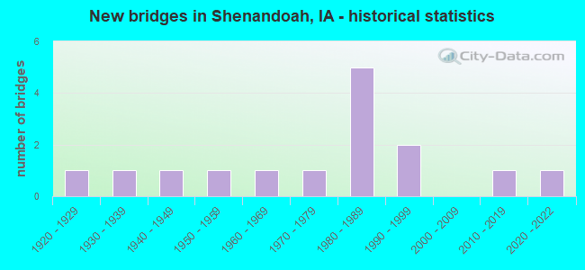
- New bridges - historical statistics
- 11920-1929
- 11930-1939
- 11940-1949
- 11950-1959
- 11960-1969
- 11970-1979
- 51980-1989
- 21990-1999
- 12010-2019
- 12020-2022

- Reconstructed bridges - Historical Statistics
- 11950-1959
- 01960-1969
- 01970-1979
- 01980-1989
- 11990-1999

- Bridge Condition - Deck
- 11.1%Excellent
- 22.2%Good
- 44.4%Satisfactory
- 22.2%Fair

- Bridge Condition - Superstructure
- 11.1%Excellent
- 11.1%Very good
- 11.1%Good
- 44.4%Satisfactory
- 22.2%Fair

- Bridge Condition - Substructure
- 11.1%Excellent
- 11.1%Very good
- 22.2%Good
- 22.2%Satisfactory
- 11.1%Fair
- 22.2%Poor

- Bridge Condition - Channel
- 13.3%Very good
- 20.0%Good
- 53.3%Satisfactory
- 13.3%Fair

- Bridge Condition - Culverts
- 16.7%Very good
- 50.0%Good
- 16.7%Satisfactory
- 16.7%Poor
Find on map >> Show street view
Structure Number: 1032, Location: 000000000 (Lat: 40.758831, Lng: -95.383553), Route carried "on" structure: City street , Year Built: 1930, Status: Posted for load, Structure Length: 0.76m (2.49ft), Average Daily Traffic: 1,500 (year 2016), Average Future Daily Traffic: 1,500 (year 2041), Features Intersected: JOHNSONS RUN, Facility Carried by Structure: SOUTHWEST RD
Minimum Vertical Clearance: 30+ m (98+ ft), Kilometerpoint: 0.188, Lanes on structure: 2, Owner: City or Municipal Highway Agency, Approaching Roadway Width: 7.3m (24.0ft), Material/Design: Concrete, Design/Construction: Culvert, Number Of Spans In Main Unit: 2, Length of Maximum Span: 3.7m (12.1ft)
Condition: Channel: Fair, Culverts: Poor, Operating Rating: 14.5 metric tons, Method Used To Determine Operating Rating: Field evaluation and documented engineering judgment, Inventory Rating: 10.9 metric tons, Method Used To Determine Inventory Rating: Field evaluation and documented engineering judgment, Structural Evaluation: High priority of corrective action, Waterway Adequacy: Somewhat better than minimum adequacy, Approach Roadway Alignment: Somewhat better than minimum adequacy, Bridge Posting: Required (Relationship of Operating Rating to Maximum Legal Load: > 39.9% below), Designated Inspection Frequency: Every 24 months, Inspection Date: March 2021
Find on map >> Show street view
Structure Number: 1035, Location: 000000000 (Lat: 40.769036, Lng: -95.362208), Route carried "on" structure: City street , Year Built: 1950, Status: Posted for load, Structure Length: 2.13m (6.99ft), Average Daily Traffic: 415 (year 1979), Average Future Daily Traffic: 415 (year 2041), Features Intersected: FOUR MILE CREEK, Facility Carried by Structure: ARGUS RD
Minimum Vertical Clearance: 30+ m (98+ ft), Kilometerpoint: 0.283, Lanes on structure: 1, Owner: City or Municipal Highway Agency, Approaching Roadway Width: 7.3m (24.0ft), Skew: 1 degrees, Material/Design: Wood or Timber, Design/Construction: Stringer/Multi-beam, Number Of Spans In Main Unit: 3, Length of Maximum Span: 7.0m (23.0ft), Curb-To-Curb Width: 5.5m (18.0ft), Out-to-Out Width: 5.8m (19.0ft)
Condition: Deck: Satisfactory, Superstructure: Satisfactory, Substructure: Poor, Channel: Satisfactory, Operating Rating: 21.1 metric tons, Method Used To Determine Operating Rating: Allowable Stress (AS), Inventory Rating: 14.8 metric tons, Method Used To Determine Inventory Rating: Allowable Stress (AS), Structural Evaluation: Meets minimum limits, Deck Geometry: High priority of replacement, Waterway Adequacy: Better than present minimum criteria, Approach Roadway Alignment: Equal to present minimum criteria, Bridge Posting: Required (Relationship of Operating Rating to Maximum Legal Load: 30.0 - 39.9% below), Length Of Structure Improvement: 7.50m (24.61ft), Designated Inspection Frequency: Every 24 months, Inspection Date: March 2021, Bridge Improvement Cost: $113,000, Roadway Improvement Cost: $12,000, Deck Structure Type: Wood or Timber, Wearing Surface/Protective System: Wearing Surface: Wood or Timber
Find on map >> Show street view
Structure Number: 25231, Location: 1.5 MI. S OF IA 2 (Lat: 40.721897, Lng: -95.388664), Route carried "on" structure: US 59, Year Built: 1985, Status: Open, Structure Length: 4.45m (14.60ft), Average Daily Traffic: 1,610 (year 2020), Truck Traffic: 16%, Average Future Daily Traffic: 1,610 (year 2041), Design Load: HS 20, Features Intersected: FISHERS CREEK
Minimum Vertical Clearance: 30+ m (98+ ft), Kilometerpoint: 15.698, Lanes on structure: 2, Base Highway Network: Yes, Owner: State Highway Agency, Approaching Roadway Width: 12.2m (40.0ft), Material/Design: Prestressed concrete, Design/Construction: Stringer/Multi-beam, Number Of Spans In Main Unit: 3, Length of Maximum Span: 17.4m (57.1ft), Curb-To-Curb Width: 12.2m (40.0ft), Out-to-Out Width: 13.1m (43.0ft)
Condition: Deck: Good, Superstructure: Very good, Substructure: Very good, Channel: Good, Operating Rating: 70.6 metric tons, Method Used To Determine Operating Rating: Load Factor (LF), Inventory Rating: 32.8 metric tons, Method Used To Determine Inventory Rating: Load Factor (LF), Structural Evaluation: Equal to present desirable criteria, Deck Geometry: Better than present minimum criteria, Waterway Adequacy: Equal to present minimum criteria, Approach Roadway Alignment: Equal to present desirable criteria, Designated Inspection Frequency: Every 24 months, Inspection Date: January 2021, Deck Structure Type: Concrete Cast-file-Place, Wearing Surface/Protective System: Wearing Surface: Monolithic Concrete, Deck Protection: Epoxy Coated Reinforcing
Find on map >> Show street view
Structure Number: 25401, Location: 069402403 (Lat: 40.772000, Lng: -95.400758), Route carried "on" structure: County highway , Year Built: 1977, Status: Open, Structure Length: 11.31m (37.11ft), Average Daily Traffic: 850 (year 2016), Truck Traffic: 11%, Average Future Daily Traffic: 850 (year 2041), Design Load: HS 20, Features Intersected: E NISHNABOTNA RIVER, Facility Carried by Structure: 190 STREET
Minimum Vertical Clearance: 30+ m (98+ ft), Kilometerpoint: 25.552, Lanes on structure: 2, Owner: County Highway Agency, Approaching Roadway Width: 11.0m (36.1ft), Skew: 3 degrees, Material/Design: Prestressed concrete, Design/Construction: Stringer/Multi-beam, Number Of Spans In Main Unit: 4, Length of Maximum Span: 28.0m (91.9ft), Curb-To-Curb Width: 9.1m (29.9ft), Out-to-Out Width: 10.1m (33.1ft)
Condition: Deck: Satisfactory, Superstructure: Satisfactory, Substructure: Good, Channel: Fair, Operating Rating: 65.2 metric tons, Method Used To Determine Operating Rating: Load Factor (LF), Inventory Rating: 39.1 metric tons, Method Used To Determine Inventory Rating: Load Factor (LF), Structural Evaluation: Equal to present minimum criteria, Deck Geometry: Equal to present minimum criteria, Waterway Adequacy: Somewhat better than minimum adequacy, Approach Roadway Alignment: Equal to present desirable criteria, Designated Inspection Frequency: Every 24 months, Inspection Date: May 2021, Deck Structure Type: Concrete Cast-file-Place, Wearing Surface/Protective System: Wearing Surface: Monolithic Concrete
Find on map >> Show street view
Structure Number: 3861, Location: 1.0 MI. N. OF IA. 48 (Lat: 40.785208, Lng: -95.384800), Route carried "on" structure: US 59, Year Built: 1929, Year Reconstructed: 1958, Status: Open, Structure Length: 11.49m (37.70ft), Average Daily Traffic: 1,600 (year 2020), Truck Traffic: 16%, Average Future Daily Traffic: 1,600 (year 2041), Design Load: H 20, Features Intersected: EAST NISHNABOTNA RIVER
Minimum Vertical Clearance: 30+ m (98+ ft), Kilometerpoint: 22.761, Lanes on structure: 2, Base Highway Network: Yes, Owner: State Highway Agency, Approaching Roadway Width: 13.4m (44.0ft), Skew: 2 degrees, Material/Design: Steel continuous, Design/Construction: Stringer/Multi-beam, Number Of Spans In Main Unit: 3, Length of Maximum Span: 44.2m (145.0ft), Curb-To-Curb Width: 8.5m (27.9ft), Out-to-Out Width: 10.4m (34.1ft)
Condition: Deck: Fair, Superstructure: Fair, Substructure: Fair, Channel: Satisfactory, Operating Rating: 62.5 metric tons, Method Used To Determine Operating Rating: Load Factor (LF), Inventory Rating: 37.5 metric tons, Method Used To Determine Inventory Rating: Load Factor (LF), Structural Evaluation: Somewhat better than minimum adequacy, Deck Geometry: Somewhat better than minimum adequacy, Waterway Adequacy: Equal to present minimum criteria, Approach Roadway Alignment: Equal to present desirable criteria, Designated Inspection Frequency: Every 24 months, Inspection Date: July 2021, Deck Structure Type: Concrete Cast-file-Place, Wearing Surface/Protective System: Wearing Surface: Low Slump Concrete
Find on map >> Show street view
Structure Number: 38841, Location: 1.0 E OF Jct. U.S. 59 (Lat: 40.771828, Lng: -95.366139), Route carried "on" structure: State highway 48, Year Built: 1995, Status: Open, Structure Length: 1.80m (5.91ft), Average Daily Traffic: 2,680 (year 2020), Truck Traffic: 6%, Average Future Daily Traffic: 2,680 (year 2041), Design Load: HS 20, Features Intersected: FOUR MILE CREEK
Minimum Vertical Clearance: 30+ m (98+ ft), Kilometerpoint: 1.592, Lanes on structure: 2, Base Highway Network: Yes, Owner: State Highway Agency, Approaching Roadway Width: 10.1m (33.1ft), Skew: 5 degrees, Material/Design: Concrete continuous, Design/Construction: Culvert, Number Of Spans In Main Unit: 3, Length of Maximum Span: 5.8m (19.0ft)
Condition: Channel: Satisfactory, Culverts: Satisfactory, Operating Rating: 50.6 metric tons, Method Used To Determine Operating Rating: Load Factor (LF), Inventory Rating: 30.3 metric tons, Method Used To Determine Inventory Rating: Load Factor (LF), Structural Evaluation: Equal to present minimum criteria, Waterway Adequacy: Equal to present desirable criteria, Approach Roadway Alignment: Equal to present desirable criteria, Designated Inspection Frequency: Every 24 months, Inspection Date: October 2021
Find on map >> Show street view
Structure Number: 3885, Location: 2.2 MI. N OF JCT. 59 (Lat: 40.783108, Lng: -95.358994), Route carried "on" structure: State highway 48, Year Built: 1969, Status: Open, Structure Length: 0.76m (2.49ft), Average Daily Traffic: 2,190 (year 2020), Truck Traffic: 8%, Average Future Daily Traffic: 2,190 (year 2040), Design Load: HS 20, Features Intersected: FISHBAUGH DITCH
Minimum Vertical Clearance: 30+ m (98+ ft), Kilometerpoint: 3.042, Lanes on structure: 2, Base Highway Network: Yes, Owner: State Highway Agency, Approaching Roadway Width: 13.4m (44.0ft), Material/Design: Concrete continuous, Design/Construction: Culvert, Number Of Spans In Main Unit: 2, Length of Maximum Span: 3.7m (12.1ft)
Condition: Channel: Good, Culverts: Good, Operating Rating: 48.2 metric tons, Method Used To Determine Operating Rating: Load Factor (LF), Inventory Rating: 28.8 metric tons, Method Used To Determine Inventory Rating: Load Factor (LF), Structural Evaluation: Better than present minimum criteria, Waterway Adequacy: Somewhat better than minimum adequacy, Approach Roadway Alignment: Equal to present desirable criteria, Designated Inspection Frequency: Every 24 months, Inspection Date: April 2020
Find on map >> Show street view
Structure Number: 265971, Location: 068390702 (Lat: 40.717169, Lng: -95.371147), Route carried "on" structure: County highway , Year Built: 1985, Status: Open, Structure Length: 3.51m (11.52ft), Average Daily Traffic: 40 (year 2016), Average Future Daily Traffic: 40 (year 2041), Design Load: H 20, Features Intersected: FISHER CREEK, Facility Carried by Structure: FREMONT AVE
Minimum Vertical Clearance: 30+ m (98+ ft), Kilometerpoint: 15.186, Lanes on structure: 2, Owner: County Highway Agency, Approaching Roadway Width: 9.4m (30.8ft), Skew: 3 degrees, Material/Design: Concrete continuous, Design/Construction: Slab, Number Of Spans In Main Unit: 3, Length of Maximum Span: 13.4m (44.0ft), Curb-To-Curb Width: 7.3m (24.0ft), Out-to-Out Width: 8.3m (27.2ft)
Condition: Deck: Good, Superstructure: Good, Substructure: Satisfactory, Channel: Satisfactory, Operating Rating: 56.7 metric tons, Method Used To Determine Operating Rating: Allowable Stress (AS), Inventory Rating: 30.8 metric tons, Method Used To Determine Inventory Rating: Allowable Stress (AS), Structural Evaluation: Equal to present minimum criteria, Deck Geometry: Equal to present minimum criteria, Waterway Adequacy: Better than present minimum criteria, Approach Roadway Alignment: Better than present minimum criteria, Designated Inspection Frequency: Every 24 months, Inspection Date: May 2021, Deck Structure Type: Concrete Cast-file-Place, Wearing Surface/Protective System: Wearing Surface: Monolithic Concrete
Find on map >> Show street view
Structure Number: 265991, Location: 068390804 (Lat: 40.723269, Lng: -95.351850), Route carried "on" structure: County highway , Year Built: 2017, Status: Open, Structure Length: 1.34m (4.40ft), Average Daily Traffic: 150 (year 2016), Truck Traffic: 17%, Average Future Daily Traffic: 150 (year 2040), Design Load: HL 93, Features Intersected: FISHER CREEK, Facility Carried by Structure: J40 B AVE
Minimum Vertical Clearance: 30+ m (98+ ft), Kilometerpoint: 15.933, Lanes on structure: 2, Owner: County Highway Agency, Approaching Roadway Width: 13.4m (44.0ft), Skew: 3 degrees, Material/Design: Concrete continuous, Design/Construction: Culvert, Number Of Spans In Main Unit: 3, Length of Maximum Span: 4.3m (14.1ft)
Condition: Channel: Very good, Culverts: Very good, Operating Rating: 58.0 metric tons, Method Used To Determine Operating Rating: Load and Resistance Factor Rating (LRFR) rating reported by rating factor(RF) method using HL-93 loadings, Inventory Rating: 44.7 metric tons, Method Used To Determine Inventory Rating: Load and Resistance Factor Rating (LRFR) rating reported by rating factor(RF) method using HL-93 loadings, Structural Evaluation: Equal to present desirable criteria, Waterway Adequacy: Equal to present desirable criteria, Approach Roadway Alignment: Equal to present desirable criteria, Designated Inspection Frequency: Every 48 months, Inspection Date: November 2020
Find on map >> Show street view
Structure Number: 267311, Location: 069390802 (Lat: 40.790244, Lng: -95.366075), Route carried "on" structure: County highway , Year Built: 2020, Status: Open, Structure Length: 11.03m (36.19ft), Average Daily Traffic: 110 (year 2016), Average Future Daily Traffic: 110 (year 2040), Design Load: HL 93, Features Intersected: NISHNABOTNA RIVER, Facility Carried by Structure: A AVENUE
Minimum Vertical Clearance: 30+ m (98+ ft), Kilometerpoint: 4.027, Lanes on structure: 2, Owner: County Highway Agency, Approaching Roadway Width: 8.5m (27.9ft), Skew: 2 degrees, Material/Design: Prestressed concrete, Design/Construction: Stringer/Multi-beam, Number Of Spans In Main Unit: 3, Length of Maximum Span: 41.8m (137.1ft), Curb-To-Curb Width: 9.1m (29.9ft), Out-to-Out Width: 10.0m (32.8ft)
Condition: Deck: Excellent, Superstructure: Excellent, Substructure: Excellent, Channel: Very good, Operating Rating: 42.1 metric tons, Method Used To Determine Operating Rating: Assigned ratings based on Load and Resistance Factor Design (LRFD) reported by rating factor (RF) using HL93 loadings, Inventory Rating: 32.4 metric tons, Method Used To Determine Inventory Rating: Assigned ratings based on Load and Resistance Factor Design (LRFD) reported by rating factor (RF) using HL93 loadings, Structural Evaluation: Equal to present desirable criteria, Deck Geometry: Equal to present minimum criteria, Waterway Adequacy: Better than present minimum criteria, Approach Roadway Alignment: Equal to present desirable criteria, Designated Inspection Frequency: Every 24 months, Inspection Date: November 2020, Deck Structure Type: Concrete Cast-file-Place, Wearing Surface/Protective System: Wearing Surface: Monolithic Concrete, Deck Protection: Epoxy Coated Reinforcing
Find on map >> Show street view
Structure Number: 26734, Location: 069390906 (Lat: 40.791311, Lng: -95.347017), Route carried "on" structure: County highway , Year Built: 1990, Year Reconstructed: 2003, Status: Open, Structure Length: 0.73m (2.40ft), Average Daily Traffic: 30 (year 2016), Average Future Daily Traffic: 30 (year 2040), Features Intersected: STREAM, Facility Carried by Structure: B AVENUE
Minimum Vertical Clearance: 30+ m (98+ ft), Kilometerpoint: 21.885, Lanes on structure: 2, Owner: County Highway Agency, Approaching Roadway Width: 8.5m (27.9ft), Skew: 3 degrees, Material/Design: Wood or Timber, Design/Construction: Slab, Number Of Spans In Main Unit: 1, Length of Maximum Span: 7.0m (23.0ft), Curb-To-Curb Width: 7.3m (24.0ft), Out-to-Out Width: 7.8m (25.6ft)
Condition: Deck: Satisfactory, Superstructure: Satisfactory, Substructure: Good, Channel: Satisfactory, Operating Rating: 75.1 metric tons, Method Used To Determine Operating Rating: Allowable Stress (AS), Inventory Rating: 54.1 metric tons, Method Used To Determine Inventory Rating: Allowable Stress (AS), Structural Evaluation: Equal to present minimum criteria, Deck Geometry: Equal to present minimum criteria, Waterway Adequacy: Better than present minimum criteria, Approach Roadway Alignment: Equal to present desirable criteria, Designated Inspection Frequency: Every 24 months, Inspection Date: November 2020, Deck Structure Type: Wood or Timber, Wearing Surface/Protective System: Wearing Surface: Wood or Timber
Find on map >> Show street view
Structure Number: 267431, Location: 069391702 (Lat: 40.783883, Lng: -95.366131), Route carried "on" structure: County highway , Year Built: 1980, Status: Open, Structure Length: 0.94m (3.08ft), Average Daily Traffic: 110 (year 2016), Average Future Daily Traffic: 110 (year 2040), Features Intersected: STREAM, Facility Carried by Structure: A AVENUE
Minimum Vertical Clearance: 30+ m (98+ ft), Kilometerpoint: 3.320, Lanes on structure: 2, Owner: County Highway Agency, Approaching Roadway Width: 7.3m (24.0ft), Material/Design: Prestressed concrete, Design/Construction: Tee Beam, Number Of Spans In Main Unit: 1, Length of Maximum Span: 8.8m (28.9ft), Curb-To-Curb Width: 7.5m (24.6ft), Out-to-Out Width: 7.7m (25.3ft)
Condition: Deck: Fair, Superstructure: Fair, Substructure: Poor, Channel: Satisfactory, Operating Rating: 25.1 metric tons, Method Used To Determine Operating Rating: Field evaluation and documented engineering judgment, Inventory Rating: 18.4 metric tons, Method Used To Determine Inventory Rating: Field evaluation and documented engineering judgment, Structural Evaluation: Meets minimum limits, Deck Geometry: Somewhat better than minimum adequacy, Waterway Adequacy: Equal to present minimum criteria, Approach Roadway Alignment: Equal to present desirable criteria, Length Of Structure Improvement: 5.00m (16.40ft), Designated Inspection Frequency: Every 24 months, Inspection Date: November 2020, Bridge Improvement Cost: $100,000, Roadway Improvement Cost: $10,000, Deck Structure Type: Concrete Precast Panels, Wearing Surface/Protective System: Wearing Surface: Monolithic Concrete
Find on map >> Show street view
Structure Number: 267441, Location: 069392102 (Lat: 40.766014, Lng: -95.347067), Route carried "on" structure: County highway , Year Built: 1988, Status: Open, Structure Length: 0.76m (2.49ft), Average Daily Traffic: 60 (year 2016), Average Future Daily Traffic: 60 (year 2038), Design Load: HS 20, Features Intersected: FOURMILE CREEK, Facility Carried by Structure: B AVENUE
Minimum Vertical Clearance: 30+ m (98+ ft), Kilometerpoint: 19.077, Lanes on structure: 2, Owner: County Highway Agency, Approaching Roadway Width: 9.1m (29.9ft), Skew: 1 degrees, Material/Design: Concrete continuous, Design/Construction: Culvert, Number Of Spans In Main Unit: 2, Length of Maximum Span: 3.7m (12.1ft)
Condition: Channel: Good, Culverts: Good, Operating Rating: 44.1 metric tons, Method Used To Determine Operating Rating: Assigned rating based on Load Factor Design (LFD) reported in metric tons, Inventory Rating: 32.7 metric tons, Method Used To Determine Inventory Rating: Assigned rating based on Load Factor Design (LFD) reported in metric tons, Structural Evaluation: Better than present minimum criteria, Waterway Adequacy: Better than present minimum criteria, Approach Roadway Alignment: Equal to present desirable criteria, Designated Inspection Frequency: Every 48 months, Inspection Date: December 2018
Find on map >> Show street view
Structure Number: 267451, Location: 069392202 (Lat: 40.757642, Lng: -95.327975), Route carried "on" structure: County highway , Year Built: 1989, Status: Open, Structure Length: 0.91m (2.99ft), Average Daily Traffic: 90 (year 2016), Average Future Daily Traffic: 90 (year 2038), Design Load: HS 20, Features Intersected: FOUR MILE CREEK, Facility Carried by Structure: C AVENUE
Minimum Vertical Clearance: 30+ m (98+ ft), Kilometerpoint: 19.977, Lanes on structure: 2, Owner: County Highway Agency, Approaching Roadway Width: 8.5m (27.9ft), Skew: 4 degrees, Material/Design: Concrete continuous, Design/Construction: Culvert, Number Of Spans In Main Unit: 2, Length of Maximum Span: 4.3m (14.1ft)
Condition: Channel: Satisfactory, Culverts: Good, Operating Rating: 44.1 metric tons, Method Used To Determine Operating Rating: Assigned rating based on Load Factor Design (LFD) reported in metric tons, Inventory Rating: 32.7 metric tons, Method Used To Determine Inventory Rating: Assigned rating based on Load Factor Design (LFD) reported in metric tons, Structural Evaluation: Better than present minimum criteria, Waterway Adequacy: Better than present minimum criteria, Approach Roadway Alignment: Better than present minimum criteria, Designated Inspection Frequency: Every 48 months, Inspection Date: December 2018
Find on map >> Show street view
Structure Number: 505565, Location: 69403601 (Lat: 40.728253, Lng: -95.404114), Route carried "on" structure: State lands road , Year Built: 1940, Status: Posted for load, Structure Length: 0.73m (2.40ft), Features Intersected: UNNAMED CREEK, Facility Carried by Structure: MANTI PARK
Minimum Vertical Clearance: 30+ m (98+ ft), Kilometerpoint: 0.103, Lanes on structure: 2, Owner: City or Municipal Highway Agency, Approaching Roadway Width: 3.4m (11.2ft), Material/Design: Wood or Timber, Design/Construction: Stringer/Multi-beam, Number Of Spans In Main Unit: 1, Length of Maximum Span: 6.8m (22.3ft), Curb-To-Curb Width: 7.3m (24.0ft), Out-to-Out Width: 7.6m (24.9ft)
Condition: Deck: Satisfactory, Superstructure: Satisfactory, Substructure: Satisfactory, Channel: Satisfactory, Operating Rating: 14.0 metric tons, Method Used To Determine Operating Rating: Allowable Stress (AS), Inventory Rating: 9.5 metric tons, Method Used To Determine Inventory Rating: Allowable Stress (AS), Structural Evaluation: High priority of corrective action, Deck Geometry: Equal to present minimum criteria, Waterway Adequacy: Equal to present minimum criteria, Approach Roadway Alignment: Meets minimum limits, Bridge Posting: Required (Relationship of Operating Rating to Maximum Legal Load: > 39.9% below), Designated Inspection Frequency: Every 24 months, Inspection Date: March 2021, Deck Structure Type: Wood or Timber