Bridge Statistics for Sherman, Illinois (IL)
Condition, Traffic, Stress, Structural Evaluation, Project Costs
- National Bridge Inventory (NBI) Statistics
- 18Number of bridges
- 486ft / 148mTotal length
- $600,000Total costs
- 180,350Total average daily traffic
- 48,647Total average daily truck traffic
- National Bridge Inventory (NBI) Registered Bridges for Sherman
- No street view available for this location
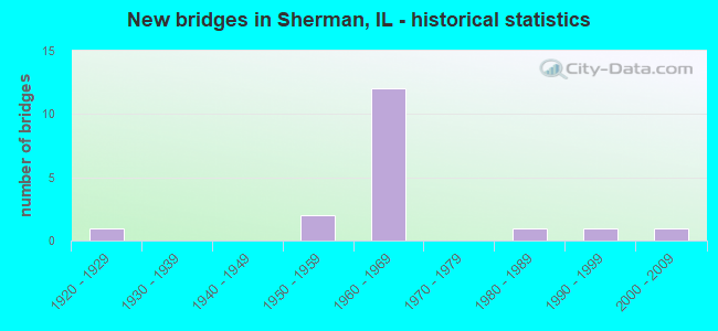
- New bridges - historical statistics
- 11920-1929
- 21950-1959
- 121960-1969
- 11980-1989
- 11990-1999
- 12000-2009

- Reconstructed bridges - Historical Statistics
- 81980-1989
- 01990-1999
- 12000-2009
- 12010-2019


- Bridge Condition - Deck
- 7.7%Very good
- 53.8%Good
- 38.5%Satisfactory

- Bridge Condition - Superstructure
- 7.7%Very good
- 30.8%Good
- 53.8%Satisfactory
- 7.7%Poor

- Bridge Condition - Substructure
- 92.3%Good
- 7.7%Satisfactory

- Bridge Condition - Channel
- 11.1%Very good
- 66.7%Good
- 22.2%Satisfactory
Find on map >> Show street view
Structure Number: 840018, Location: 2.8M N IL54/SANG. AV (Lat: 39.870136, Lng: -89.596028), Route carried "on" structure: Interstate 55, Year Built: 1963, Year Reconstructed: 1993, Status: Open, Structure Length: 34.29m (112.50ft), Average Daily Traffic: 13,650 (year 2021), Truck Traffic: 34%, Average Future Daily Traffic: 15,169 (year 2032), Design Load: HS 20+Mod, Features Intersected: SANGAMON RIVER
Minimum Vertical Clearance: 30+ m (98+ ft), Kilometerpoint: 164.374, Lanes on structure: 2, Base Highway Network: Yes, Owner: State Highway Agency, Approaching Roadway Width: 13.4m (44.0ft), Material/Design: Steel continuous, Design/Construction: Stringer/Multi-beam, Number Of Spans In Main Unit: 3, Number Of Approach Spans: 11, Length of Maximum Span: 54.9m (180.1ft), Curb-To-Curb Width: 13.4m (44.0ft), Out-to-Out Width: 14.4m (47.2ft)
Condition: Deck: Satisfactory, Superstructure: Satisfactory, Substructure: Good, Channel: Satisfactory, Operating Rating: 97.2 metric tons, Method Used To Determine Operating Rating: Load Factor (LF) rating reported by rating factor (RF) method using MS18 loading, Inventory Rating: 51.2 metric tons, Method Used To Determine Inventory Rating: Load Factor (LF) rating reported by rating factor (RF) method using MS18 loading, Structural Evaluation: Equal to present minimum criteria, Deck Geometry: Superior to present desirable criteria, Waterway Adequacy: Superior to present desirable criteria, Approach Roadway Alignment: Equal to present desirable criteria, Designated Inspection Frequency: Every 24 months, Underwater Inspection Frequency: Every 60 months, Inspection Date: November 2020, Underwater Inspection Date: July 2018, Deck Structure Type: Concrete Cast-file-Place, Wearing Surface/Protective System: Deck Protection: Epoxy Coated Reinforcing
Find on map >> Show street view
Structure Number: 840019, Location: 2.8M N IL54/SANG. AV (Lat: 39.870281, Lng: -89.596039), Route carried "on" structure: Interstate 55, Year Built: 1963, Year Reconstructed: 1993, Status: Open, Structure Length: 34.29m (112.50ft), Average Daily Traffic: 13,650 (year 2021), Truck Traffic: 34%, Average Future Daily Traffic: 15,169 (year 2032), Design Load: HS 20+Mod, Features Intersected: SANGAMON RIVER
Minimum Vertical Clearance: 30+ m (98+ ft), Kilometerpoint: 164.390, Lanes on structure: 2, Base Highway Network: Yes, Owner: State Highway Agency, Approaching Roadway Width: 13.4m (44.0ft), Material/Design: Steel continuous, Design/Construction: Stringer/Multi-beam, Number Of Spans In Main Unit: 3, Number Of Approach Spans: 8, Length of Maximum Span: 54.9m (180.1ft), Curb-To-Curb Width: 13.4m (44.0ft), Out-to-Out Width: 14.4m (47.2ft)
Condition: Deck: Satisfactory, Superstructure: Satisfactory, Substructure: Good, Channel: Good, Operating Rating: 97.2 metric tons, Method Used To Determine Operating Rating: Load Factor (LF) rating reported by rating factor (RF) method using MS18 loading, Inventory Rating: 51.2 metric tons, Method Used To Determine Inventory Rating: Load Factor (LF) rating reported by rating factor (RF) method using MS18 loading, Structural Evaluation: Equal to present minimum criteria, Deck Geometry: Superior to present desirable criteria, Waterway Adequacy: Superior to present desirable criteria, Approach Roadway Alignment: Equal to present desirable criteria, Designated Inspection Frequency: Every 24 months, Underwater Inspection Frequency: Every 60 months, Inspection Date: November 2020, Underwater Inspection Date: July 2018, Deck Structure Type: Concrete Cast-file-Place, Wearing Surface/Protective System: Deck Protection: Epoxy Coated Reinforcing
Find on map >> Show street view
Structure Number: 84002, Location: SHERMAN INTERCHANGE (Lat: 39.902808, Lng: -89.594339), Route carried "on" structure: Interstate 55, Year Built: 1962, Year Reconstructed: 1993, Status: Open, Structure Length: 11.01m (36.12ft), Average Daily Traffic: 13,650 (year 2021), Truck Traffic: 34%, Average Future Daily Traffic: 17,098 (year 2032), Design Load: HS 20+Mod, Features Intersected: BL 55 & UP RR
Minimum Vertical Clearance: 30+ m (98+ ft), Kilometerpoint: 167.898, Lanes on structure: 2, Lanes under structure: 2, Base Highway Network: Yes, Owner: State Highway Agency, Approaching Roadway Width: 13.4m (44.0ft), Skew: 3 degrees, Material/Design: Steel continuous, Design/Construction: Stringer/Multi-beam, Number Of Spans In Main Unit: 5, Length of Maximum Span: 23.6m (77.4ft), Curb-To-Curb Width: 13.4m (44.0ft), Out-to-Out Width: 14.4m (47.2ft)
Condition: Deck: Satisfactory, Superstructure: Poor, Substructure: Good, Operating Rating: 89.1 metric tons, Method Used To Determine Operating Rating: Load Factor (LF) rating reported by rating factor (RF) method using MS18 loading, Inventory Rating: 54.1 metric tons, Method Used To Determine Inventory Rating: Load Factor (LF) rating reported by rating factor (RF) method using MS18 loading, Structural Evaluation: Meets minimum limits, Deck Geometry: Superior to present desirable criteria, Underclear: Superior to present desirable criteria, Approach Roadway Alignment: Equal to present desirable criteria, Designated Inspection Frequency: Every 12 months, Inspection Date: May 2021, Deck Structure Type: Concrete Cast-file-Place, Wearing Surface/Protective System: Wearing Surface: Other, Deck Protection: Epoxy Coated Reinforcing
Find on map >> Show street view
Structure Number: 840021, Location: SHERMAN INTERCHANGE (Lat: 39.902978, Lng: -89.594400), Route carried "on" structure: Interstate 55, Year Built: 1962, Year Reconstructed: 2015, Status: Open, Structure Length: 11.02m (36.15ft), Average Daily Traffic: 13,650 (year 2021), Truck Traffic: 34%, Average Future Daily Traffic: 17,098 (year 2032), Design Load: HS 20+Mod, Features Intersected: BL 55 & UP RR
Minimum Vertical Clearance: 30+ m (98+ ft), Kilometerpoint: 167.914, Lanes on structure: 3, Lanes under structure: 2, Base Highway Network: Yes, Owner: State Highway Agency, Approaching Roadway Width: 1.9m (6.2ft), Skew: 3 degrees, Material/Design: Steel continuous, Design/Construction: Stringer/Multi-beam, Number Of Spans In Main Unit: 5, Length of Maximum Span: 23.6m (77.4ft), Curb-To-Curb Width: 17.8m (58.4ft), Out-to-Out Width: 18.8m (61.7ft)
Condition: Deck: Satisfactory, Superstructure: Satisfactory, Substructure: Good, Operating Rating: 97.2 metric tons, Method Used To Determine Operating Rating: Load Factor (LF) rating reported by rating factor (RF) method using MS18 loading, Inventory Rating: 53.8 metric tons, Method Used To Determine Inventory Rating: Load Factor (LF) rating reported by rating factor (RF) method using MS18 loading, Structural Evaluation: Equal to present minimum criteria, Deck Geometry: Better than present minimum criteria, Underclear: Superior to present desirable criteria, Approach Roadway Alignment: Equal to present desirable criteria, Designated Inspection Frequency: Every 24 months, Inspection Date: May 2021, Deck Structure Type: Concrete Cast-file-Place, Wearing Surface/Protective System: Deck Protection: Epoxy Coated Reinforcing
Find on map >> Show street view
Structure Number: 840022, Location: 1M N SHERMAN INTCHG (Lat: 39.914761, Lng: -89.587211), Route carried "on" structure: Interstate 55, Year Built: 1962, Year Reconstructed: 1993, Status: Open, Structure Length: 4.59m (15.06ft), Average Daily Traffic: 13,650 (year 2021), Truck Traffic: 34%, Average Future Daily Traffic: 17,098 (year 2032), Design Load: HS 20+Mod, Features Intersected: FANCY CREEK
Minimum Vertical Clearance: 30+ m (98+ ft), Kilometerpoint: 169.733, Lanes on structure: 2, Base Highway Network: Yes, Owner: State Highway Agency, Approaching Roadway Width: 13.4m (44.0ft), Material/Design: Steel continuous, Design/Construction: Stringer/Multi-beam, Number Of Spans In Main Unit: 3, Length of Maximum Span: 16.5m (54.1ft), Curb-To-Curb Width: 13.6m (44.6ft), Out-to-Out Width: 14.5m (47.6ft)
Condition: Deck: Good, Superstructure: Satisfactory, Substructure: Good, Channel: Good, Operating Rating: 77.4 metric tons, Method Used To Determine Operating Rating: Load Factor (LF) rating reported by rating factor (RF) method using MS18 loading, Inventory Rating: 46.3 metric tons, Method Used To Determine Inventory Rating: Load Factor (LF) rating reported by rating factor (RF) method using MS18 loading, Structural Evaluation: Equal to present minimum criteria, Deck Geometry: Superior to present desirable criteria, Waterway Adequacy: Superior to present desirable criteria, Approach Roadway Alignment: Equal to present desirable criteria, Designated Inspection Frequency: Every 24 months, Inspection Date: October 2020, Deck Structure Type: Concrete Cast-file-Place, Wearing Surface/Protective System: Deck Protection: Epoxy Coated Reinforcing
Find on map >> Show street view
Structure Number: 840023, Location: 1M N SHERMAN INTCHG (Lat: 39.914808, Lng: -89.587039), Route carried "on" structure: Interstate 55, Year Built: 1962, Year Reconstructed: 1993, Status: Open, Structure Length: 4.59m (15.06ft), Average Daily Traffic: 13,650 (year 2021), Truck Traffic: 34%, Average Future Daily Traffic: 17,098 (year 2032), Design Load: HS 20+Mod, Features Intersected: FANCY CREEK
Minimum Vertical Clearance: 30+ m (98+ ft), Kilometerpoint: 169.749, Lanes on structure: 3, Base Highway Network: Yes, Owner: State Highway Agency, Approaching Roadway Width: 18.3m (60.0ft), Material/Design: Steel continuous, Design/Construction: Stringer/Multi-beam, Number Of Spans In Main Unit: 3, Length of Maximum Span: 16.5m (54.1ft), Curb-To-Curb Width: 17.1m (56.1ft), Out-to-Out Width: 18.0m (59.1ft)
Condition: Deck: Good, Superstructure: Satisfactory, Substructure: Good, Channel: Good, Operating Rating: 71.3 metric tons, Method Used To Determine Operating Rating: Load Factor (LF) rating reported by rating factor (RF) method using MS18 loading, Inventory Rating: 42.8 metric tons, Method Used To Determine Inventory Rating: Load Factor (LF) rating reported by rating factor (RF) method using MS18 loading, Structural Evaluation: Equal to present minimum criteria, Deck Geometry: Equal to present minimum criteria, Waterway Adequacy: Superior to present desirable criteria, Approach Roadway Alignment: Equal to present desirable criteria, Designated Inspection Frequency: Every 24 months, Inspection Date: October 2020, Deck Structure Type: Concrete Cast-file-Place, Wearing Surface/Protective System: Deck Protection: Epoxy Coated Reinforcing
Find on map >> Show street view
Structure Number: 840025, Location: 1M N SHERMAN INTCHG (Lat: 39.914889, Lng: -89.588392), Route carried "on" structure: Other road , Year Built: 1959, Year Reconstructed: 2008, Status: Open, Structure Length: 4.58m (15.03ft), Average Daily Traffic: 950 (year 2012), Truck Traffic: 4%, Average Future Daily Traffic: 965 (year 2032), Design Load: HS 20+Mod, Features Intersected: FANCY CREEK, Facility Carried by Structure: I-55 W FR/W OUTER
Minimum Vertical Clearance: 30+ m (98+ ft), Kilometerpoint: 1.400, Lanes on structure: 2, Owner: State Highway Agency, Approaching Roadway Width: 8.5m (27.9ft), Material/Design: Steel continuous, Design/Construction: Stringer/Multi-beam, Number Of Spans In Main Unit: 3, Length of Maximum Span: 16.5m (54.1ft), Curb-To-Curb Width: 8.9m (29.2ft), Out-to-Out Width: 9.7m (31.8ft)
Condition: Deck: Very good, Superstructure: Good, Substructure: Good, Channel: Satisfactory, Operating Rating: 71.6 metric tons, Method Used To Determine Operating Rating: Load Factor (LF) rating reported by rating factor (RF) method using MS18 loading, Inventory Rating: 42.8 metric tons, Method Used To Determine Inventory Rating: Load Factor (LF) rating reported by rating factor (RF) method using MS18 loading, Structural Evaluation: Better than present minimum criteria, Deck Geometry: Somewhat better than minimum adequacy, Waterway Adequacy: Superior to present desirable criteria, Approach Roadway Alignment: Equal to present desirable criteria, Designated Inspection Frequency: Every 48 months, Inspection Date: September 2020, Deck Structure Type: Concrete Cast-file-Place, Wearing Surface/Protective System: Deck Protection: Epoxy Coated Reinforcing
Find on map >> Show street view
Structure Number: 84003, Location: .9M N DIRKSEN PKWY (Lat: 39.869706, Lng: -89.613872), Route carried "on" structure: Business Interstate 55, Year Built: 1926, Year Reconstructed: 1988, Status: Open, Structure Length: 19.28m (63.25ft), Average Daily Traffic: 16,100 (year 2021), Truck Traffic: 4%, Average Future Daily Traffic: 16,294 (year 2032), Design Load: HS 20, Features Intersected: SANGAMON RIVER
Minimum Vertical Clearance: 30+ m (98+ ft), Kilometerpoint: 16.399, Lanes on structure: 4, Base Highway Network: Yes, Owner: State Highway Agency, Approaching Roadway Width: 19.5m (64.0ft), Material/Design: Steel continuous, Design/Construction: Stringer/Multi-beam, Number Of Spans In Main Unit: 3, Number Of Approach Spans: 4, Length of Maximum Span: 48.6m (159.4ft), Curb-To-Curb Width: 19.5m (64.0ft), Out-to-Out Width: 20.5m (67.3ft)
Condition: Deck: Good, Superstructure: Satisfactory, Substructure: Good, Channel: Very good, Operating Rating: 52.2 metric tons, Method Used To Determine Operating Rating: Load Factor (LF) rating reported by rating factor (RF) method using MS18 loading, Inventory Rating: 29.8 metric tons, Method Used To Determine Inventory Rating: Load Factor (LF) rating reported by rating factor (RF) method using MS18 loading, Structural Evaluation: Equal to present minimum criteria, Deck Geometry: Better than present minimum criteria, Waterway Adequacy: Superior to present desirable criteria, Approach Roadway Alignment: Equal to present desirable criteria, Designated Inspection Frequency: Every 24 months, Underwater Inspection Frequency: Every 60 months, Inspection Date: October 2020, Underwater Inspection Date: July 2018, Deck Structure Type: Concrete Cast-file-Place, Wearing Surface/Protective System: Wearing Surface: Other, Deck Protection: Epoxy Coated Reinforcing
Find on map >> Show street view
Structure Number: 840031, Location: .9M N SHERMAN INTCHG (Lat: 39.913414, Lng: -89.585725), Route carried "on" structure: Business Interstate 55, Year Built: 1953, Status: Open, Structure Length: 2.67m (8.76ft), Average Daily Traffic: 4,700 (year 2021), Truck Traffic: 7%, Average Future Daily Traffic: 4,610 (year 2032), Design Load: HS 20, Features Intersected: FANCY CREEK
Minimum Vertical Clearance: 30+ m (98+ ft), Kilometerpoint: 21.967, Lanes on structure: 1, Base Highway Network: Yes, Owner: State Highway Agency, Approaching Roadway Width: 9.8m (32.2ft), Material/Design: Concrete continuous, Design/Construction: Slab, Number Of Spans In Main Unit: 3, Number Of Approach Spans: 3, Length of Maximum Span: 10.1m (33.1ft), Curb or Sidewalk Widths: Left: 0.6m (2.0ft), Right: 0.6m (2.0ft), Curb-To-Curb Width: 8.5m (27.9ft), Out-to-Out Width: 10.5m (34.4ft)
Condition: Deck: Satisfactory, Superstructure: Satisfactory, Substructure: Satisfactory, Channel: Good, Operating Rating: 58.0 metric tons, Method Used To Determine Operating Rating: Load Factor (LF) rating reported by rating factor (RF) method using MS18 loading, Inventory Rating: 35.0 metric tons, Method Used To Determine Inventory Rating: Load Factor (LF) rating reported by rating factor (RF) method using MS18 loading, Structural Evaluation: Equal to present minimum criteria, Deck Geometry: Meets minimum limits, Waterway Adequacy: Superior to present desirable criteria, Approach Roadway Alignment: Equal to present desirable criteria, Length Of Structure Improvement: 3.47m (11.38ft), Designated Inspection Frequency: Every 24 months, Inspection Date: May 2021, Bridge Improvement Cost: $400,000, Roadway Improvement Cost: $40,000, Total Project Cost: $600,000, Deck Structure Type: Concrete Cast-file-Place, Wearing Surface/Protective System: Wearing Surface: Other
Find on map >> Show street view
Structure Number: 840088, Location: .5M S SHERMAN INTCHG (Lat: 39.895792, Lng: -89.595667), Route carried "on" structure: Other road , Year Built: 1963, Year Reconstructed: 1989, Status: Open, Structure Length: 6.93m (22.74ft), Average Daily Traffic: 3,350 (year 2012), Truck Traffic: 7%, Average Future Daily Traffic: 3,806 (year 2032), Design Load: HS 20, Features Intersected: I-55, Facility Carried by Structure: CH 1 / SHERMAN RD.
Minimum Vertical Clearance: 30+ m (98+ ft), Kilometerpoint: 2.189, Lanes on structure: 2, Lanes under structure: 4, Owner: State Highway Agency, Approaching Roadway Width: 11.0m (36.1ft), Skew: 1 degrees, Material/Design: Steel continuous, Design/Construction: Stringer/Multi-beam, Number Of Spans In Main Unit: 4, Length of Maximum Span: 21.0m (68.9ft), Curb-To-Curb Width: 9.1m (29.9ft), Out-to-Out Width: 10.1m (33.1ft)
Condition: Deck: Good, Superstructure: Very good, Substructure: Good, Operating Rating: 59.3 metric tons, Method Used To Determine Operating Rating: Load Factor (LF) rating reported by rating factor (RF) method using MS18 loading, Inventory Rating: 35.6 metric tons, Method Used To Determine Inventory Rating: Load Factor (LF) rating reported by rating factor (RF) method using MS18 loading, Structural Evaluation: Better than present minimum criteria, Deck Geometry: Meets minimum limits, Underclear: Somewhat better than minimum adequacy, Approach Roadway Alignment: Equal to present desirable criteria, Designated Inspection Frequency: Every 24 months, Inspection Date: May 2021, Deck Structure Type: Concrete Cast-file-Place, Wearing Surface/Protective System: Deck Protection: Epoxy Coated Reinforcing
Find on map >> Show street view
Structure Number: 8401, Location: .5M N SHERMAN INTCHG (Lat: 39.910325, Lng: -89.595175), Route carried "on" structure: County highway , Year Built: 1962, Year Reconstructed: 1989, Status: Open, Structure Length: 7.54m (24.74ft), Average Daily Traffic: 950 (year 2012), Truck Traffic: 2%, Average Future Daily Traffic: 348 (year 2032), Design Load: HS 20, Features Intersected: I-55, Facility Carried by Structure: SUDDUTH RD. FAU 80
Minimum Vertical Clearance: 30+ m (98+ ft), Kilometerpoint: 4.281, Lanes on structure: 2, Lanes under structure: 4, Owner: State Highway Agency, Approaching Roadway Width: 9.1m (29.9ft), Skew: 2 degrees, Material/Design: Steel continuous, Design/Construction: Stringer/Multi-beam, Number Of Spans In Main Unit: 4, Length of Maximum Span: 22.8m (74.8ft), Curb-To-Curb Width: 8.5m (27.9ft), Out-to-Out Width: 9.5m (31.2ft)
Condition: Deck: Good, Superstructure: Good, Substructure: Good, Operating Rating: 66.7 metric tons, Method Used To Determine Operating Rating: Load Factor (LF) rating reported by rating factor (RF) method using MS18 loading, Inventory Rating: 39.9 metric tons, Method Used To Determine Inventory Rating: Load Factor (LF) rating reported by rating factor (RF) method using MS18 loading, Structural Evaluation: Better than present minimum criteria, Deck Geometry: Somewhat better than minimum adequacy, Underclear: Somewhat better than minimum adequacy, Approach Roadway Alignment: Equal to present desirable criteria, Designated Inspection Frequency: Every 24 months, Inspection Date: October 2020, Deck Structure Type: Concrete Cast-file-Place, Wearing Surface/Protective System: Deck Protection: Epoxy Coated Reinforcing
Find on map >> Show street view
Structure Number: 843427, Location: 1.0 E OF SHERMAN (Lat: 39.895831, Lng: -89.586128), Route carried "on" structure: Other road , Year Built: 1984, Status: Open, Structure Length: 3.13m (10.27ft), Average Daily Traffic: 1,800 (year 2012), Truck Traffic: 6%, Average Future Daily Traffic: 2,090 (year 2032), Design Load: HS 20, Features Intersected: FANCY CREEK, Facility Carried by Structure: SHERMAN RD CH 1
Minimum Vertical Clearance: 30+ m (98+ ft), Kilometerpoint: 3.009, Lanes on structure: 2, Owner: County Highway Agency, Approaching Roadway Width: 6.7m (22.0ft), Material/Design: Prestressed concrete, Design/Construction: Box Beam or Girders - Multiple, Number Of Spans In Main Unit: 3, Length of Maximum Span: 9.9m (32.5ft), Curb-To-Curb Width: 10.1m (33.1ft), Out-to-Out Width: 10.1m (33.1ft)
Condition: Deck: Good, Superstructure: Good, Substructure: Good, Channel: Good, Operating Rating: 60.9 metric tons, Method Used To Determine Operating Rating: Load Factor (LF) rating reported by rating factor (RF) method using MS18 loading, Inventory Rating: 36.6 metric tons, Method Used To Determine Inventory Rating: Load Factor (LF) rating reported by rating factor (RF) method using MS18 loading, Structural Evaluation: Better than present minimum criteria, Deck Geometry: Somewhat better than minimum adequacy, Waterway Adequacy: Equal to present desirable criteria, Approach Roadway Alignment: Equal to present desirable criteria, Designated Inspection Frequency: Every 48 months, Inspection Date: March 2019, Deck Structure Type: Concrete Precast Panels, Wearing Surface/Protective System: Wearing Surface: Bituminous, Membrane: Built-up, Deck Protection: Internally Sealed
Find on map >> Show street view
Structure Number: 843468, Location: 3.0 W WILLIAMSVILLE (Lat: 39.910286, Lng: -89.582842), Route carried "on" structure: County highway , Year Built: 1991, Status: Open, Structure Length: 4.39m (14.40ft), Average Daily Traffic: 950 (year 2012), Truck Traffic: 2%, Average Future Daily Traffic: 348 (year 2032), Design Load: HS 20, Features Intersected: FANCY CREEK, Facility Carried by Structure: TR 33 (7.5N)
Minimum Vertical Clearance: 30+ m (98+ ft), Kilometerpoint: 5.343, Lanes on structure: 2, Owner: Town or Township Highway Agency, Approaching Roadway Width: 6.1m (20.0ft), Material/Design: Prestressed concrete, Design/Construction: Box Beam or Girders - Multiple, Number Of Spans In Main Unit: 3, Length of Maximum Span: 14.5m (47.6ft), Curb-To-Curb Width: 8.2m (26.9ft), Out-to-Out Width: 8.2m (26.9ft)
Condition: Deck: Good, Superstructure: Good, Substructure: Good, Channel: Good, Operating Rating: 44.4 metric tons, Method Used To Determine Operating Rating: Assigned rating based on Load Factor Design (LFD) reported by rating factor (RF) using MS18 loading, Inventory Rating: 32.4 metric tons, Method Used To Determine Inventory Rating: Assigned rating based on Load Factor Design (LFD) reported by rating factor (RF) using MS18 loading, Structural Evaluation: Better than present minimum criteria, Deck Geometry: Somewhat better than minimum adequacy, Waterway Adequacy: Better than present minimum criteria, Approach Roadway Alignment: Equal to present desirable criteria, Designated Inspection Frequency: Every 48 months, Inspection Date: March 2019, Deck Structure Type: Concrete Precast Panels, Wearing Surface/Protective System: Wearing Surface: Bituminous
Find on map >> Show street view
Structure Number: 84002, Location: SHERMAN INTERCHANGE (Lat: 39.903414, Lng: -89.594578), Route carried "under" structure: Business Interstate 55, Year Built: 1962, Structure Length: 0. m, Average Daily Traffic: 4,700 (year 2021), Truck Traffic: 7%, Features Intersected: BL 55 & UP RR
Minimum Vertical Clearance: 7.14m (23.43ft), Kilometerpoint: 20.631, Lanes on structure: 2, Lanes under structure: 2, Material/Design: Steel continuous, Design/Construction: Stringer/Multi-beam, Length of Maximum Span: 23.6m (77.4ft)
Find on map >> Show street view
Structure Number: 840021, Location: SHERMAN INTERCHANGE (Lat: 39.903181, Lng: -89.594792), Route carried "under" structure: Business Interstate 55, Year Built: 1962, Structure Length: 0. m, Average Daily Traffic: 8,200 (year 2021), Truck Traffic: 5%, Features Intersected: BL 55 & UP RR
Minimum Vertical Clearance: 7.09m (23.26ft), Kilometerpoint: 20.615, Lanes on structure: 3, Lanes under structure: 2, Material/Design: Steel continuous, Design/Construction: Stringer/Multi-beam, Length of Maximum Span: 23.6m (77.4ft)
Find on map >> Show street view
Structure Number: 840088, Location: .5M S SHERMAN INTCHG (Lat: 39.895794, Lng: -89.595033), Route carried "under" structure: Interstate 55, Year Built: 1963, Structure Length: 0. m, Average Daily Traffic: 27,300 (year 2021), Truck Traffic: 34%, Features Intersected: I-55, Facility Carried by Structure: CH 1 / SHERMAN RD.
Minimum Vertical Clearance: 5.13m (16.83ft), Kilometerpoint: 167.238, Lanes on structure: 2, Lanes under structure: 4, Material/Design: Steel continuous, Design/Construction: Stringer/Multi-beam, Length of Maximum Span: 21.0m (68.9ft)
Find on map >> Show street view
Structure Number: 8401, Location: .5M N SHERMAN INTCHG (Lat: 39.910328, Lng: -89.594561), Route carried "under" structure: Interstate 55, Year Built: 1962, Structure Length: 0. m, Average Daily Traffic: 27,300 (year 2021), Truck Traffic: 34%, Features Intersected: I-55, Facility Carried by Structure: SUDDUTH RD. FAU 80
Minimum Vertical Clearance: 5.28m (17.32ft), Kilometerpoint: 168.880, Lanes on structure: 2, Lanes under structure: 4, Material/Design: Steel continuous, Design/Construction: Stringer/Multi-beam, Length of Maximum Span: 22.8m (74.8ft)
Find on map >> Show street view
Structure Number: 849946, Location: E OF BL55 IN SHERMAN (Lat: 39.881414, Lng: -89.609147), Route carried "under" structure: Other road , Year Built: 2005, Structure Length: 0. m, Average Daily Traffic: 2,150 (year 2012), Truck Traffic: 5%, Features Intersected: MEREDITH DRIVE, Facility Carried by Structure: UNION PACIFIC RR
Minimum Vertical Clearance: 5.03m (16.50ft), Kilometerpoint: 2.285, Lanes under structure: 2, Material/Design: Steel, Design/Construction: Stringer/Multi-beam, Length of Maximum Span: 20.1m (65.9ft)