Bridge Statistics for Sidney, New York (NY)
Condition, Traffic, Stress, Structural Evaluation, Project Costs
- National Bridge Inventory (NBI) Statistics
- 17Number of bridges
- 256ft / 77.7mTotal length
- $64,347,000Total costs
- 67,015Total average daily traffic
- 5,647Total average daily truck traffic
- National Bridge Inventory (NBI) Registered Bridges for Sidney
- No street view available for this location
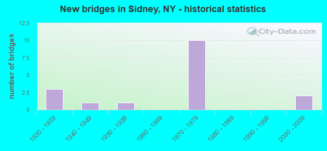
- New bridges - historical statistics
- 31930-1939
- 11940-1949
- 11950-1959
- 101970-1979
- 22000-2009

- Reconstructed bridges - Historical Statistics
- 11970-1979
- 01980-1989
- 11990-1999
- 12000-2009


- Bridge Condition - Deck
- 15.4%Very good
- 30.8%Good
- 38.5%Satisfactory
- 15.4%Fair

- Bridge Condition - Superstructure
- 23.1%Very good
- 38.5%Good
- 38.5%Fair

- Bridge Condition - Substructure
- 7.7%Very good
- 38.5%Good
- 23.1%Satisfactory
- 23.1%Fair
- 7.7%Poor

- Bridge Condition - Channel
- 28.6%Good
- 28.6%Satisfactory
- 28.6%Fair
- 14.3%Poor
Find on map >> Show street view
Structure Number: 100385, Location: 2.7 MI NE JCT SH7 & SH206 (Lat: 42.300042, Lng: -75.433422), Route carried "on" structure: State highway 7, Year Built: 1936, Status: Open, Structure Length: 2.68m (8.79ft), Average Daily Traffic: 3,094 (year 2015), Truck Traffic: 7%, Average Future Daily Traffic: 3,227 (year 2040), Features Intersected: D&H RR
Minimum Vertical Clearance: 30+ m (98+ ft), Kilometerpoint: 22.027, Lanes on structure: 2, Base Highway Network: Yes, Owner: State Highway Agency, Approaching Roadway Width: 9.1m (29.9ft), Skew: 4 degrees, Material/Design: Steel, Design/Construction: Girder and Floorbeam System, Number Of Spans In Main Unit: 1, Length of Maximum Span: 26.2m (86.0ft), Curb or Sidewalk Widths: Left: 0.3m (1.0ft), Right: 0.3m (1.0ft), Curb-To-Curb Width: 9.9m (32.5ft), Out-to-Out Width: 11.3m (37.1ft)
Condition: Deck: Fair, Superstructure: Fair, Substructure: Fair, Operating Rating: 48.0 metric tons, Method Used To Determine Operating Rating: Load and Resistance Factor Rating (LRFR) rating reported by rating factor(RF) method using HL-93 loadings, Inventory Rating: 36.9 metric tons, Method Used To Determine Inventory Rating: Load and Resistance Factor Rating (LRFR) rating reported by rating factor(RF) method using HL-93 loadings, Structural Evaluation: Somewhat better than minimum adequacy, Deck Geometry: Meets minimum limits, Underclear: Somewhat better than minimum adequacy, Approach Roadway Alignment: Meets minimum limits, Length Of Structure Improvement: 2.68m (8.79ft), Designated Inspection Frequency: Every 24 months, Critical Feature Inspection Frequency: Every 24 months, Inspection Date: September 2021, Critical Feature Inspection Date: September 2021, Bridge Improvement Cost: $1,714,000, Roadway Improvement Cost: $1,003,000, Total Project Cost: $2,717,000 ( Estimate for 2021), Deck Structure Type: Concrete Cast-file-Place, Wearing Surface/Protective System: Wearing Surface: Monolithic Concrete
Find on map >> Show street view
Structure Number: 100386, Location: JCT SH 7 & UNADILLA RIVER (Lat: 42.317442, Lng: -75.409833), Route carried "on" structure: State highway 7, Year Built: 2002, Status: Open, Structure Length: 9.02m (29.59ft), Average Daily Traffic: 3,179 (year 2019), Truck Traffic: 5%, Average Future Daily Traffic: 3,933 (year 2040), Design Load: HS 25 or greater, Features Intersected: UNADILLA RIVER
Minimum Vertical Clearance: 30+ m (98+ ft), Kilometerpoint: 0.499, Lanes on structure: 2, Base Highway Network: Yes, Owner: State Highway Agency, Approaching Roadway Width: 11.9m (39.0ft), Skew: 2 degrees, Material/Design: Steel continuous, Design/Construction: Stringer/Multi-beam, Number Of Spans In Main Unit: 2, Length of Maximum Span: 46.3m (151.9ft), Curb-To-Curb Width: 12.0m (39.4ft), Out-to-Out Width: 13.0m (42.7ft)
Condition: Deck: Good, Superstructure: Very good, Substructure: Very good, Channel: Good, Operating Rating: 56.2 metric tons, Method Used To Determine Operating Rating: Load Factor (LF), Inventory Rating: 33.6 metric tons, Method Used To Determine Inventory Rating: Load Factor (LF), Structural Evaluation: Equal to present desirable criteria, Deck Geometry: Somewhat better than minimum adequacy, Waterway Adequacy: Equal to present desirable criteria, Approach Roadway Alignment: Equal to present desirable criteria, Length Of Structure Improvement: 9.02m (29.59ft), Designated Inspection Frequency: Every 24 months, Inspection Date: July 2020, Bridge Improvement Cost: $2,533,000, Roadway Improvement Cost: $1,483,000, Total Project Cost: $4,016,000 ( Estimate for 2021), Deck Structure Type: Concrete Cast-file-Place, Wearing Surface/Protective System: Wearing Surface: Integral Concrete, Deck Protection: Epoxy Coated Reinforcing
Find on map >> Show street view
Structure Number: 100447, Location: JCT RTE 8 + SUSQUEHANNA R (Lat: 42.317853, Lng: -75.394447), Route carried "on" structure: County highway , Year Built: 1936, Year Reconstructed: 1979, Status: Open, Structure Length: 11.73m (38.48ft), Average Daily Traffic: 4,712 (year 2017), Truck Traffic: 4%, Average Future Daily Traffic: 5,830 (year 2040), Features Intersected: SUSQUEHANNA RIVER, Facility Carried by Structure: MAIN STREET
Minimum Vertical Clearance: 30+ m (98+ ft), Kilometerpoint: 0.451, Lanes on structure: 2, Owner: County Highway Agency, Approaching Roadway Width: 8.5m (27.9ft), Skew: 2 degrees, Material/Design: Steel, Design/Construction: Truss - Thru, Number Of Spans In Main Unit: 3, Length of Maximum Span: 38.1m (125.0ft), Curb or Sidewalk Widths: Left: 1.9m (6.2ft), Right: 1.9m (6.2ft), Curb-To-Curb Width: 9.1m (29.9ft), Out-to-Out Width: 14.0m (45.9ft)
Condition: Deck: Satisfactory, Superstructure: Fair, Substructure: Poor, Channel: Poor, Operating Rating: 50.8 metric tons, Method Used To Determine Operating Rating: Load Factor (LF), Inventory Rating: 29.9 metric tons, Method Used To Determine Inventory Rating: Load Factor (LF), Structural Evaluation: Meets minimum limits, Deck Geometry: Meets minimum limits, Waterway Adequacy: Meets minimum limits, Approach Roadway Alignment: Equal to present desirable criteria, Length Of Structure Improvement: 11.73m (38.48ft), Designated Inspection Frequency: Every 24 months, Critical Feature Inspection Frequency: Every 24 months, Underwater Inspection Frequency: Every 60 months, Inspection Date: September 2020, Critical Feature Inspection Date: September 2020, Underwater Inspection Date: April 2021, Bridge Improvement Cost: $11,404,000, Roadway Improvement Cost: $6,678,000, Total Project Cost: $18,082,000 ( Estimate for 2021), Deck Structure Type: Concrete Cast-file-Place, Wearing Surface/Protective System: Wearing Surface: Integral Concrete, Deck Protection: Epoxy Coated Reinforcing
Find on map >> Show street view
Structure Number: 104041, Location: 1.2 MI SE JCT SH 206 & SH (Lat: 42.249608, Lng: -75.430339), Route carried "on" structure: State highway 206, Year Built: 1959, Year Reconstructed: 2012, Status: Open, Structure Length: 0.82m (2.69ft), Average Daily Traffic: 1,297 (year 2016), Truck Traffic: 9%, Average Future Daily Traffic: 1,305 (year 2040), Design Load: H 20, Features Intersected: UNNAMED CREEK
Minimum Vertical Clearance: 30+ m (98+ ft), Kilometerpoint: 40.450, Lanes on structure: 2, Base Highway Network: Yes, Owner: State Highway Agency, Approaching Roadway Width: 11.6m (38.1ft), Material/Design: Concrete, Design/Construction: Channel Beam, Number Of Spans In Main Unit: 1, Length of Maximum Span: 7.9m (25.9ft), Curb-To-Curb Width: 9.8m (32.2ft), Out-to-Out Width: 11.3m (37.1ft)
Condition: Deck: Satisfactory, Superstructure: Fair, Substructure: Fair, Channel: Good, Operating Rating: 70.0 metric tons, Method Used To Determine Operating Rating: Field evaluation and documented engineering judgment, Inventory Rating: 27.5 metric tons, Method Used To Determine Inventory Rating: Field evaluation and documented engineering judgment, Structural Evaluation: Somewhat better than minimum adequacy, Deck Geometry: Somewhat better than minimum adequacy, Waterway Adequacy: Somewhat better than minimum adequacy, Approach Roadway Alignment: Equal to present desirable criteria, Length Of Structure Improvement: 0.82m (2.69ft), Designated Inspection Frequency: Every 24 months, Inspection Date: September 2020, Bridge Improvement Cost: $1,475,000, Roadway Improvement Cost: $864,000, Total Project Cost: $2,338,000 ( Estimate for 2021), Wearing Surface/Protective System: Wearing Surface: Bituminous
Find on map >> Show street view
Structure Number: 1094999, Location: JCT RTS 8 & I-88 (Lat: 42.293458, Lng: -75.406358), Route carried "on" structure: State highway 8, Year Built: 1977, Status: Open, Structure Length: 7.19m (23.59ft), Average Daily Traffic: 7,084 (year 2020), Truck Traffic: 13%, Average Future Daily Traffic: 7,225 (year 2040), Design Load: HS 20, Features Intersected: 88I 88I93031005 WB, RTE
Minimum Vertical Clearance: 30+ m (98+ ft), Kilometerpoint: 31.874, Lanes on structure: 5, Lanes under structure: 8, Base Highway Network: Yes, Owner: State Highway Agency, Approaching Roadway Width: 23.2m (76.1ft), Skew: 21 degrees, Material/Design: Steel continuous, Design/Construction: Stringer/Multi-beam, Number Of Spans In Main Unit: 2, Length of Maximum Span: 35.6m (116.8ft), Curb-To-Curb Width: 23.6m (77.4ft), Out-to-Out Width: 25.0m (82.0ft)
Condition: Deck: Satisfactory, Superstructure: Good, Substructure: Satisfactory, Operating Rating: 79.8 metric tons, Method Used To Determine Operating Rating: Load Factor (LF), Inventory Rating: 48.1 metric tons, Method Used To Determine Inventory Rating: Load Factor (LF), Structural Evaluation: Equal to present minimum criteria, Deck Geometry: Better than present minimum criteria, Underclear: Somewhat better than minimum adequacy, Approach Roadway Alignment: Equal to present desirable criteria, Length Of Structure Improvement: 7.19m (23.59ft), Designated Inspection Frequency: Every 24 months, Inspection Date: June 2020, Bridge Improvement Cost: $4,380,000, Roadway Improvement Cost: $2,565,000, Total Project Cost: $6,946,000 ( Estimate for 2021), Deck Structure Type: Concrete Cast-file-Place, Wearing Surface/Protective System: Wearing Surface: Integral Concrete
Find on map >> Show street view
Structure Number: 1095, Location: JCT SH 8 & SUSQUEHANNA RV (Lat: 42.315853, Lng: -75.412308), Route carried "on" structure: State highway 8, Year Built: 1977, Status: Open, Structure Length: 15.39m (50.49ft), Average Daily Traffic: 6,353 (year 2018), Truck Traffic: 10%, Average Future Daily Traffic: 6,480 (year 2040), Design Load: HS 20, Features Intersected: SUSQUEHANNA RIVER
Minimum Vertical Clearance: 30+ m (98+ ft), Kilometerpoint: 0.000, Lanes on structure: 2, Base Highway Network: Yes, Owner: State Highway Agency, Approaching Roadway Width: 14.6m (47.9ft), Material/Design: Steel, Design/Construction: Stringer/Multi-beam, Number Of Spans In Main Unit: 4, Length of Maximum Span: 45.1m (148.0ft), Curb-To-Curb Width: 14.6m (47.9ft), Out-to-Out Width: 15.2m (49.9ft)
Condition: Deck: Satisfactory, Superstructure: Good, Substructure: Satisfactory, Channel: Satisfactory, Inventory Rating: 60.8 metric tons, Method Used To Determine Inventory Rating: Load Factor (LF), Structural Evaluation: Equal to present minimum criteria, Deck Geometry: Superior to present desirable criteria, Waterway Adequacy: Somewhat better than minimum adequacy, Approach Roadway Alignment: Equal to present desirable criteria, Length Of Structure Improvement: 15.39m (50.49ft), Designated Inspection Frequency: Every 24 months, Underwater Inspection Frequency: Every 60 months, Inspection Date: July 2020, Underwater Inspection Date: September 2018, Bridge Improvement Cost: $5,099,000, Roadway Improvement Cost: $2,986,000, Total Project Cost: $8,085,000 ( Estimate for 2021), Deck Structure Type: Concrete Cast-file-Place, Wearing Surface/Protective System: Wearing Surface: Integral Concrete
Find on map >> Show street view
Structure Number: 1095019, Location: .8 MI N JCT RTS 8 & I-88 (Lat: 42.306614, Lng: -75.403178), Route carried "on" structure: State highway 8, Year Built: 1977, Status: Open, Structure Length: 7.10m (23.29ft), Average Daily Traffic: 7,084 (year 2018), Truck Traffic: 11%, Average Future Daily Traffic: 7,225 (year 2040), Design Load: HS 20, Features Intersected: NORFOLK SOUTHERN RR
Minimum Vertical Clearance: 30+ m (98+ ft), Kilometerpoint: 33.338, Lanes on structure: 4, Base Highway Network: Yes, Owner: State Highway Agency, Approaching Roadway Width: 26.8m (87.9ft), Skew: 33 degrees, Material/Design: Prestressed concrete, Design/Construction: Stringer/Multi-beam, Number Of Spans In Main Unit: 3, Length of Maximum Span: 28.9m (94.8ft), Curb-To-Curb Width: 26.6m (87.3ft), Out-to-Out Width: 27.5m (90.2ft)
Condition: Deck: Good, Superstructure: Good, Substructure: Good, Operating Rating: 62.6 metric tons, Method Used To Determine Operating Rating: Load Factor (LF), Inventory Rating: 33.6 metric tons, Method Used To Determine Inventory Rating: Load Factor (LF), Structural Evaluation: Better than present minimum criteria, Deck Geometry: Superior to present desirable criteria, Underclear: Somewhat better than minimum adequacy, Approach Roadway Alignment: Equal to present desirable criteria, Length Of Structure Improvement: 7.10m (23.29ft), Designated Inspection Frequency: Every 24 months, Inspection Date: June 2020, Bridge Improvement Cost: $4,058,000, Roadway Improvement Cost: $2,376,000, Total Project Cost: $6,434,000 ( Estimate for 2021), Deck Structure Type: Concrete Cast-file-Place, Wearing Surface/Protective System: Wearing Surface: Integral Concrete
Find on map >> Show street view
Structure Number: 1095121, Location: .8 MILE E JCT I88 & SH 8 (Lat: 42.294789, Lng: -75.388628), Route carried "on" structure: Interstate 88, Year Built: 1974, Status: Open, Structure Length: 3.38m (11.09ft), Average Daily Traffic: 5,395 (year 2009), Truck Traffic: 27%, Average Future Daily Traffic: 7,552 (year 2029), Design Load: HS 20, Features Intersected: West Main Street / Co. R
Minimum Vertical Clearance: 30+ m (98+ ft), Kilometerpoint: 2.253, Lanes on structure: 2, Lanes under structure: 2, Base Highway Network: Yes, Owner: State Highway Agency, Approaching Roadway Width: 12.2m (40.0ft), Skew: 2 degrees, Material/Design: Steel, Design/Construction: Stringer/Multi-beam, Number Of Spans In Main Unit: 1, Length of Maximum Span: 32.6m (107.0ft), Curb-To-Curb Width: 12.5m (41.0ft), Out-to-Out Width: 13.6m (44.6ft)
Condition: Deck: Good, Superstructure: Good, Substructure: Good, Operating Rating: 78.0 metric tons, Method Used To Determine Operating Rating: Load Factor (LF), Inventory Rating: 46.3 metric tons, Method Used To Determine Inventory Rating: Load Factor (LF), Structural Evaluation: Better than present minimum criteria, Deck Geometry: Better than present minimum criteria, Underclear: High priority of corrective action, Approach Roadway Alignment: Equal to present desirable criteria, Length Of Structure Improvement: 3.38m (11.09ft), Designated Inspection Frequency: Every 24 months, Inspection Date: March 2020, Bridge Improvement Cost: $1,326,000, Roadway Improvement Cost: $777,000, Total Project Cost: $2,103,000 ( Estimate for 2021), Deck Structure Type: Concrete Cast-file-Place, Wearing Surface/Protective System: Wearing Surface: Integral Concrete
Find on map >> Show street view
Structure Number: 1095122, Location: .8 MILE E JCT I88 & SH 8 (Lat: 42.294406, Lng: -75.388603), Route carried "on" structure: Interstate 88, Year Built: 1974, Status: Open, Structure Length: 3.38m (11.09ft), Average Daily Traffic: 4,545 (year 2019), Truck Traffic: 23%, Average Future Daily Traffic: 5,978 (year 2040), Design Load: HS 20, Features Intersected: West Main Street / Co. R
Minimum Vertical Clearance: 30+ m (98+ ft), Kilometerpoint: 2.253, Lanes on structure: 2, Lanes under structure: 2, Base Highway Network: Yes, Owner: State Highway Agency, Approaching Roadway Width: 12.2m (40.0ft), Skew: 2 degrees, Material/Design: Steel, Design/Construction: Stringer/Multi-beam, Number Of Spans In Main Unit: 1, Length of Maximum Span: 32.6m (107.0ft), Curb-To-Curb Width: 12.5m (41.0ft), Out-to-Out Width: 13.6m (44.6ft)
Condition: Deck: Good, Superstructure: Good, Substructure: Good, Operating Rating: 78.0 metric tons, Method Used To Determine Operating Rating: Load Factor (LF), Inventory Rating: 46.3 metric tons, Method Used To Determine Inventory Rating: Load Factor (LF), Structural Evaluation: Better than present minimum criteria, Deck Geometry: Better than present minimum criteria, Underclear: High priority of corrective action, Approach Roadway Alignment: Equal to present desirable criteria, Length Of Structure Improvement: 3.38m (11.09ft), Designated Inspection Frequency: Every 24 months, Inspection Date: March 2020, Bridge Improvement Cost: $1,326,000, Roadway Improvement Cost: $777,000, Total Project Cost: $2,103,000 ( Estimate for 2021), Deck Structure Type: Concrete Cast-file-Place, Wearing Surface/Protective System: Wearing Surface: Integral Concrete
Find on map >> Show street view
Structure Number: 109513, Location: 26 MI E JCT RTS I-88 + 8 (Lat: 42.311092, Lng: -75.362597), Route carried "on" structure: City street , Year Built: 1974, Status: Open, Structure Length: 8.72m (28.61ft), Average Daily Traffic: 149 (year 2019), Truck Traffic: 5%, Average Future Daily Traffic: 209 (year 2039), Design Load: HS 20, Features Intersected: 88I 88I93031032, RTE I88, Facility Carried by Structure: PINE HILL ROAD
Minimum Vertical Clearance: 30+ m (98+ ft), Kilometerpoint: 3.475, Lanes on structure: 2, Lanes under structure: 4, Owner: State Highway Agency, Approaching Roadway Width: 10.4m (34.1ft), Skew: 2 degrees, Material/Design: Steel, Design/Construction: Stringer/Multi-beam, Number Of Spans In Main Unit: 2, Length of Maximum Span: 45.1m (148.0ft), Curb-To-Curb Width: 10.1m (33.1ft), Out-to-Out Width: 11.0m (36.1ft)
Condition: Deck: Very good, Superstructure: Very good, Substructure: Good, Operating Rating: 59.0 metric tons, Method Used To Determine Operating Rating: Load Factor (LF), Inventory Rating: 34.5 metric tons, Method Used To Determine Inventory Rating: Load Factor (LF), Structural Evaluation: Better than present minimum criteria, Deck Geometry: Better than present minimum criteria, Underclear: Somewhat better than minimum adequacy, Approach Roadway Alignment: Equal to present desirable criteria, Length Of Structure Improvement: 8.71m (28.58ft), Designated Inspection Frequency: Every 24 months, Inspection Date: July 2020, Bridge Improvement Cost: $2,361,000, Roadway Improvement Cost: $1,382,000, Total Project Cost: $3,743,000 ( Estimate for 2021), Deck Structure Type: Concrete Cast-file-Place, Wearing Surface/Protective System: Wearing Surface: Integral Concrete
Find on map >> Show street view
Structure Number: 335017, Location: 4.6 MI OF BAINBRIDGE (Lat: 42.253247, Lng: -75.423247), Route carried "on" structure: Other road , Year Built: 2000, Status: Open, Structure Length: 1.13m (3.71ft), Average Daily Traffic: 157 (year 2016), Truck Traffic: 6%, Average Future Daily Traffic: 220 (year 2036), Design Load: HS 25 or greater, Features Intersected: BIG BROOK, Facility Carried by Structure: BUTTS ROAD TR11
Minimum Vertical Clearance: 30+ m (98+ ft), Kilometerpoint: 0.644, Lanes on structure: 2, Owner: County Highway Agency, Approaching Roadway Width: 7.6m (24.9ft), Skew: 1 degrees, Material/Design: Prestressed concrete, Design/Construction: Box Beam or Girders - Multiple, Number Of Spans In Main Unit: 1, Length of Maximum Span: 10.7m (35.1ft), Curb-To-Curb Width: 6.9m (22.6ft), Out-to-Out Width: 7.4m (24.3ft)
Condition: Deck: Very good, Superstructure: Very good, Substructure: Good, Channel: Fair, Operating Rating: 77.1 metric tons, Method Used To Determine Operating Rating: Load Factor (LF), Inventory Rating: 46.3 metric tons, Method Used To Determine Inventory Rating: Load Factor (LF), Structural Evaluation: Better than present minimum criteria, Deck Geometry: Meets minimum limits, Waterway Adequacy: Meets minimum limits, Approach Roadway Alignment: Equal to present desirable criteria, Length Of Structure Improvement: 1.12m (3.67ft), Designated Inspection Frequency: Every 24 months, Inspection Date: June 2020, Bridge Improvement Cost: $336,000, Roadway Improvement Cost: $197,000, Total Project Cost: $532,000 ( Estimate for 2021), Wearing Surface/Protective System: Wearing Surface: Bituminous, Membrane: Other
Find on map >> Show street view
Structure Number: 335364, Location: .5 MI E OF EAST GUILFORD (Lat: 42.341842, Lng: -75.393803), Route carried "on" structure: County highway , Year Built: 1948, Status: Open, Structure Length: 1.68m (5.51ft), Average Daily Traffic: 925 (year 2018), Truck Traffic: 5%, Average Future Daily Traffic: 1,295 (year 2038), Features Intersected: ROGERS HOLLOW BRK, Facility Carried by Structure: COUNTY ROAD 1
Minimum Vertical Clearance: 30+ m (98+ ft), Kilometerpoint: 2.397, Lanes on structure: 2, Owner: County Highway Agency, Approaching Roadway Width: 7.6m (24.9ft), Skew: 2 degrees, Material/Design: Steel, Design/Construction: Stringer/Multi-beam, Number Of Spans In Main Unit: 1, Length of Maximum Span: 16.5m (54.1ft), Curb-To-Curb Width: 7.3m (24.0ft), Out-to-Out Width: 7.8m (25.6ft)
Condition: Deck: Fair, Superstructure: Fair, Substructure: Fair, Channel: Fair, Operating Rating: 56.2 metric tons, Method Used To Determine Operating Rating: Load Factor (LF), Inventory Rating: 33.6 metric tons, Method Used To Determine Inventory Rating: Load Factor (LF), Structural Evaluation: Somewhat better than minimum adequacy, Deck Geometry: Meets minimum limits, Waterway Adequacy: Meets minimum limits, Approach Roadway Alignment: Meets minimum limits, Length Of Structure Improvement: 1.67m (5.48ft), Designated Inspection Frequency: Every 24 months, Inspection Date: December 2021, Bridge Improvement Cost: $441,000, Roadway Improvement Cost: $258,000, Total Project Cost: $699,000 ( Estimate for 2021), Deck Structure Type: Open Grating, Wearing Surface/Protective System: Wearing Surface: Other
Find on map >> Show street view
Structure Number: 335365, Location: .5 MI E OF EAST GUILFORD (Lat: 42.341131, Lng: -75.398478), Route carried "on" structure: County highway , Year Built: 1935, Year Reconstructed: 1995, Status: Open, Structure Length: 5.43m (17.81ft), Average Daily Traffic: 956 (year 2019), Truck Traffic: 7%, Average Future Daily Traffic: 1,338 (year 2039), Features Intersected: UNADILLA RIVER, Facility Carried by Structure: COUNTY ROAD 1
Minimum Vertical Clearance: 4.57m (14.99ft), Kilometerpoint: 22.767, Lanes on structure: 2, Owner: County Highway Agency, Approaching Roadway Width: 7.9m (25.9ft), Material/Design: Steel, Design/Construction: Truss - Thru, Number Of Spans In Main Unit: 1, Length of Maximum Span: 53.3m (174.9ft), Curb-To-Curb Width: 8.8m (28.9ft), Out-to-Out Width: 9.6m (31.5ft)
Condition: Deck: Satisfactory, Superstructure: Fair, Substructure: Satisfactory, Channel: Satisfactory, Operating Rating: 44.5 metric tons, Method Used To Determine Operating Rating: Load Factor (LF), Inventory Rating: 27.2 metric tons, Method Used To Determine Inventory Rating: Load Factor (LF), Structural Evaluation: Somewhat better than minimum adequacy, Deck Geometry: Somewhat better than minimum adequacy, Waterway Adequacy: Meets minimum limits, Approach Roadway Alignment: Equal to present desirable criteria, Length Of Structure Improvement: 5.42m (17.78ft), Designated Inspection Frequency: Every 24 months, Critical Feature Inspection Frequency: Every 24 months, Inspection Date: June 2021, Critical Feature Inspection Date: June 2021, Bridge Improvement Cost: $4,131,000, Roadway Improvement Cost: $2,419,000, Total Project Cost: $6,549,000 ( Estimate for 2021), Deck Structure Type: Concrete Cast-file-Place, Wearing Surface/Protective System: Wearing Surface: Integral Concrete
Find on map >> Show street view
Structure Number: 1094999, Location: JCT RTS 8 & I-88 (Lat: 42.293458, Lng: -75.406358), Route carried "under" structure: Interstate 88, Year Built: 1977, Structure Length: 0. m, Average Daily Traffic: 10,596 (year 1999), Features Intersected: 88I 88I93031005 WB, RTE, Facility Carried by Structure: RTE 8
Minimum Vertical Clearance: 5.31m (17.42ft), Kilometerpoint: 0.772, Lanes on structure: 5, Lanes under structure: 4, Material/Design: Steel continuous, Design/Construction: Stringer/Multi-beam, Length of Maximum Span: 35.6m (116.8ft)
Find on map >> Show street view
Structure Number: 1095121, Location: .8 MILE E JCT I88 & SH 8 (Lat: 42.294789, Lng: -75.388628), Route carried "under" structure: Other road , Year Built: 1974, Structure Length: 0. m, Average Daily Traffic: 172 (year 2020), Truck Traffic: 2%, Features Intersected: West Main Street / Co. R, Facility Carried by Structure: RTE I88
Minimum Vertical Clearance: 4.95m (16.24ft), Kilometerpoint: 3.009, Lanes on structure: 2, Lanes under structure: 2, Material/Design: Steel, Design/Construction: Stringer/Multi-beam, Length of Maximum Span: 32.6m (107.0ft)
Find on map >> Show street view
Structure Number: 1095122, Location: .8 MILE E JCT I88 & SH 8 (Lat: 42.294406, Lng: -75.388603), Route carried "under" structure: Other road , Year Built: 1974, Structure Length: 0. m, Average Daily Traffic: 172 (year 2020), Truck Traffic: 2%, Features Intersected: West Main Street / Co. R, Facility Carried by Structure: RTE I88
Minimum Vertical Clearance: 4.69m (15.39ft), Kilometerpoint: 2.977, Lanes on structure: 2, Lanes under structure: 2, Material/Design: Steel, Design/Construction: Stringer/Multi-beam, Length of Maximum Span: 32.6m (107.0ft)
Find on map >> Show street view
Structure Number: 109513, Location: 26 MI E JCT RTS I-88 + 8 (Lat: 42.311092, Lng: -75.362597), Route carried "under" structure: Interstate 88, Year Built: 1974, Structure Length: 0. m, Average Daily Traffic: 11,145 (year 2000), Features Intersected: 88I 88I93031032, RTE I88, Facility Carried by Structure: PINE HILL ROAD
Minimum Vertical Clearance: 7.01m (23.00ft), Kilometerpoint: 5.197, Lanes on structure: 2, Lanes under structure: 2, Material/Design: Steel, Design/Construction: Stringer/Multi-beam, Length of Maximum Span: 45.1m (148.0ft)