Bridge Statistics for Silver Creek, New York (NY)
Condition, Traffic, Stress, Structural Evaluation, Project Costs
- National Bridge Inventory (NBI) Statistics
- 10Number of bridges
- 36ft / 10.8mTotal length
- $10,776,000Total costs
- 29,503Total average daily traffic
- 1,253Total average daily truck traffic
- National Bridge Inventory (NBI) Registered Bridges for Silver Creek
- No street view available for this location
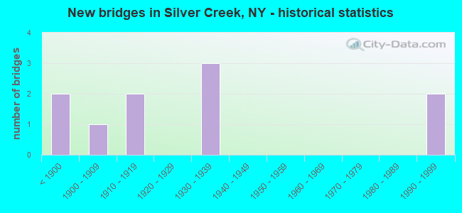
- New bridges - historical statistics
- 2Before 1900
- 11900-1909
- 21910-1919
- 31930-1939
- 21990-1999


- Bridge Condition - Deck
- 50.0%Very good
- 25.0%Good
- 25.0%Satisfactory

- Bridge Condition - Superstructure
- 75.0%Very good
- 25.0%Good

- Bridge Condition - Substructure
- 25.0%Very good
- 25.0%Good
- 50.0%Satisfactory

- Bridge Condition - Channel
- 50.0%Very good
- 25.0%Good
- 25.0%Satisfactory
Find on map >> Show street view
Structure Number: 100129, Location: 0.1 MI NW JCT RTS 5 & 20 (Lat: 42.544644, Lng: -79.168372), Route carried "on" structure: State highway 5, Year Built: 1990, Status: Open, Structure Length: 2.65m (8.69ft), Average Daily Traffic: 3,418 (year 2018), Truck Traffic: 8%, Average Future Daily Traffic: 3,450 (year 2040), Design Load: HS 20, Features Intersected: WALNUT CREEK
Minimum Vertical Clearance: 30+ m (98+ ft), Kilometerpoint: 60.096, Lanes on structure: 2, Base Highway Network: Yes, Owner: State Highway Agency, Approaching Roadway Width: 10.7m (35.1ft), Skew: 2 degrees, Material/Design: Prestressed concrete, Design/Construction: Box Beam or Girders - Multiple, Number Of Spans In Main Unit: 1, Length of Maximum Span: 24.9m (81.7ft), Curb or Sidewalk Widths: Left: 1.8m (5.9ft), Right: 1.8m (5.9ft), Curb-To-Curb Width: 12.2m (40.0ft), Out-to-Out Width: 16.5m (54.1ft)
Condition: Deck: Satisfactory, Superstructure: Good, Substructure: Satisfactory, Channel: Satisfactory, Operating Rating: 68.9 metric tons, Method Used To Determine Operating Rating: Load Factor (LF), Inventory Rating: 39.0 metric tons, Method Used To Determine Inventory Rating: Load Factor (LF), Structural Evaluation: Equal to present minimum criteria, Deck Geometry: Equal to present minimum criteria, Waterway Adequacy: High priority of corrective action, Approach Roadway Alignment: Equal to present desirable criteria, Length Of Structure Improvement: 2.65m (8.69ft), Designated Inspection Frequency: Every 24 months, Inspection Date: April 2020, Bridge Improvement Cost: $1,377,000, Roadway Improvement Cost: $807,000, Total Project Cost: $2,184,000 ( Estimate for 2021), Wearing Surface/Protective System: Wearing Surface: Monolithic Concrete
Find on map >> Show street view
Structure Number: 10013, Location: 0.1 MI NE JCT RTS 5 + 20 (Lat: 42.546047, Lng: -79.167019), Route carried "on" structure: State highway 5, Year Built: 1916, Year Reconstructed: 1997, Status: Open, Structure Length: 3.20m (10.50ft), Average Daily Traffic: 5,346 (year 2018), Truck Traffic: 10%, Average Future Daily Traffic: 5,396 (year 2040), Design Load: HS 25 or greater, Features Intersected: SILVER CREEK
Minimum Vertical Clearance: 30+ m (98+ ft), Kilometerpoint: 60.338, Lanes on structure: 2, Base Highway Network: Yes, Owner: State Highway Agency, Approaching Roadway Width: 13.4m (44.0ft), Skew: 1 degrees, Material/Design: Steel, Design/Construction: Stringer/Multi-beam, Number Of Spans In Main Unit: 1, Length of Maximum Span: 31.0m (101.7ft), Curb or Sidewalk Widths: Left: 1.5m (4.9ft), Right: 1.5m (4.9ft), Curb-To-Curb Width: 13.4m (44.0ft), Out-to-Out Width: 17.1m (56.1ft)
Condition: Deck: Very good, Superstructure: Very good, Substructure: Good, Channel: Good, Operating Rating: 75.3 metric tons, Method Used To Determine Operating Rating: Load Factor (LF), Inventory Rating: 45.4 metric tons, Method Used To Determine Inventory Rating: Load Factor (LF), Structural Evaluation: Better than present minimum criteria, Deck Geometry: Equal to present minimum criteria, Waterway Adequacy: Somewhat better than minimum adequacy, Approach Roadway Alignment: Equal to present desirable criteria, Length Of Structure Improvement: 3.20m (10.50ft), Designated Inspection Frequency: Every 24 months, Inspection Date: November 2021, Bridge Improvement Cost: $2,802,000, Roadway Improvement Cost: $1,641,000, Total Project Cost: $4,443,000 ( Estimate for 2021), Deck Structure Type: Concrete Cast-file-Place, Wearing Surface/Protective System: Wearing Surface: Integral Concrete, Deck Protection: Epoxy Coated Reinforcing
Find on map >> Show street view
Structure Number: 101542, Location: 2.1 MILE NE JCT RT 20&I90 (Lat: 42.538228, Lng: -79.169136), Route carried "on" structure: US 20, Year Built: 1991, Status: Open, Structure Length: 2.90m (9.51ft), Average Daily Traffic: 4,277 (year 2020), Truck Traffic: 6%, Average Future Daily Traffic: 4,317 (year 2040), Design Load: HS 20, Features Intersected: WALNUT CREEK
Minimum Vertical Clearance: 30+ m (98+ ft), Kilometerpoint: 59.823, Lanes on structure: 2, Base Highway Network: Yes, Owner: State Highway Agency, Approaching Roadway Width: 12.2m (40.0ft), Skew: 1 degrees, Material/Design: Prestressed concrete, Design/Construction: Box Beam or Girders - Multiple, Number Of Spans In Main Unit: 1, Length of Maximum Span: 27.7m (90.9ft), Curb or Sidewalk Widths: Left: 2.0m (6.6ft), Right: 0.0m, Curb-To-Curb Width: 12.2m (40.0ft), Out-to-Out Width: 15.3m (50.2ft)
Condition: Deck: Very good, Superstructure: Very good, Substructure: Very good, Channel: Very good, Operating Rating: 89.8 metric tons, Method Used To Determine Operating Rating: Load Factor (LF), Inventory Rating: 43.5 metric tons, Method Used To Determine Inventory Rating: Load Factor (LF), Structural Evaluation: Equal to present desirable criteria, Deck Geometry: Equal to present minimum criteria, Waterway Adequacy: Somewhat better than minimum adequacy, Approach Roadway Alignment: Equal to present desirable criteria, Length Of Structure Improvement: 2.89m (9.48ft), Designated Inspection Frequency: Every 24 months, Inspection Date: July 2021, Bridge Improvement Cost: $1,319,000, Roadway Improvement Cost: $772,000, Total Project Cost: $2,091,000 ( Estimate for 2021), Wearing Surface/Protective System: Wearing Surface: Monolithic Concrete
Find on map >> Show street view
Structure Number: 101543, Location: 2.6 MI NE JCT RT 20 + I90 (Lat: 42.543853, Lng: -79.164736), Route carried "on" structure: US 20, Year Built: 1915, Year Reconstructed: 1990, Status: Open, Structure Length: 2.04m (6.69ft), Average Daily Traffic: 4,760 (year 2018), Truck Traffic: 4%, Average Future Daily Traffic: 4,805 (year 2040), Design Load: HS 20, Features Intersected: SILVER CREEK
Minimum Vertical Clearance: 30+ m (98+ ft), Kilometerpoint: 60.691, Lanes on structure: 2, Base Highway Network: Yes, Owner: State Highway Agency, Approaching Roadway Width: 12.2m (40.0ft), Skew: 1 degrees, Material/Design: Prestressed concrete, Design/Construction: Box Beam or Girders - Multiple, Number Of Spans In Main Unit: 1, Length of Maximum Span: 20.1m (65.9ft), Curb or Sidewalk Widths: Left: 1.8m (5.9ft), Right: 1.8m (5.9ft), Curb-To-Curb Width: 12.2m (40.0ft), Out-to-Out Width: 16.5m (54.1ft)
Condition: Deck: Good, Superstructure: Very good, Substructure: Satisfactory, Channel: Very good, Operating Rating: 68.9 metric tons, Method Used To Determine Operating Rating: Load Factor (LF), Inventory Rating: 32.7 metric tons, Method Used To Determine Inventory Rating: Load Factor (LF), Structural Evaluation: Equal to present minimum criteria, Deck Geometry: Equal to present minimum criteria, Waterway Adequacy: Equal to present desirable criteria, Approach Roadway Alignment: Equal to present desirable criteria, Length Of Structure Improvement: 2.04m (6.69ft), Designated Inspection Frequency: Every 24 months, Inspection Date: April 2020, Bridge Improvement Cost: $1,298,000, Roadway Improvement Cost: $760,000, Total Project Cost: $2,058,000 ( Estimate for 2021), Wearing Surface/Protective System: Wearing Surface: Monolithic Concrete
Find on map >> Show street view
Structure Number: 700126, Location: .4 MI NW JCT SH 5 & US 20 (Lat: 42.546133, Lng: -79.175269), Route carried "under" structure: State highway 5, Year Built: 1907, Structure Length: 0. m, Average Daily Traffic: 4,898 (year 2000), Features Intersected: RTE 5, Facility Carried by Structure: CSX TRANS/ AMTRAK
Minimum Vertical Clearance: 4.39m (14.40ft), Kilometerpoint: 12.502, Lanes under structure: 2, Material/Design: Steel, Design/Construction: Girder and Floorbeam System, Length of Maximum Span: 13.7m (44.9ft)
Find on map >> Show street view
Structure Number: 700128, Location: .4 MI NW JCT SH 5 & US 20 (Lat: 42.545994, Lng: -79.174544), Route carried "under" structure: State highway 5, Year Built: 1937, Structure Length: 0. m, Average Daily Traffic: 4,898 (year 2000), Features Intersected: RTE 5, Facility Carried by Structure: NORFOLK SOUTHERN
Minimum Vertical Clearance: 4.34m (14.24ft), Kilometerpoint: 12.631, Lanes under structure: 2, Material/Design: Steel continuous, Design/Construction: Girder and Floorbeam System, Length of Maximum Span: 18.5m (60.7ft)
Find on map >> Show street view
Structure Number: 770741, Location: AT SILVER CK,JACKSON ST (Lat: 42.546933, Lng: -79.172258), Route carried "under" structure: Other road , Year Built: 1935, Structure Length: 0. m, Average Daily Traffic: 448 (year 2021), Features Intersected: JACKSON STREET, Facility Carried by Structure: NORFOLK & WESTERN
Minimum Vertical Clearance: 9.44m (30.97ft), Kilometerpoint: 0.145, Lanes under structure: 2, Material/Design: Steel, Design/Construction: Stringer/Multi-beam, Length of Maximum Span: 23.7m (77.8ft)
Find on map >> Show street view
Structure Number: 770742, Location: AT SILVER CREEK,LAKE AVE (Lat: 42.548456, Lng: -79.168600), Route carried "under" structure: Other road , Year Built: 1935, Structure Length: 0. m, Average Daily Traffic: 505 (year 2021), Features Intersected: LAKE AVENUE, Facility Carried by Structure: NORFOLK SOUTHERN
Minimum Vertical Clearance: 8.00m (26.25ft), Kilometerpoint: 0.290, Lanes under structure: 2, Material/Design: Steel, Design/Construction: Stringer/Multi-beam, Length of Maximum Span: 17.6m (57.7ft)
Find on map >> Show street view
Structure Number: 770743, Location: AT SILVER CK,JACKSON ST (Lat: 42.547353, Lng: -79.172314), Route carried "under" structure: Other road , Year Built: 1869, Structure Length: 0. m, Average Daily Traffic: 448 (year 2021), Features Intersected: JACKSON STREET, Facility Carried by Structure: CSX TRANSPRTATION
Minimum Vertical Clearance: 6.70m (21.98ft), Kilometerpoint: 0.209, Lanes under structure: 2, Material/Design: Masonry, Design/Construction: Arch - Deck, Length of Maximum Span: 11.2m (36.7ft)
Find on map >> Show street view
Structure Number: 770744, Location: AT SILVER CREEK,LAKE AVE (Lat: 42.548833, Lng: -79.168758), Route carried "under" structure: Other road , Year Built: 1869, Structure Length: 0. m, Average Daily Traffic: 505 (year 2021), Features Intersected: LAKE AVENUE, Facility Carried by Structure: CSX TRANSPRTATION
Minimum Vertical Clearance: 5.33m (17.49ft), Kilometerpoint: 0.338, Lanes under structure: 2, Material/Design: Masonry, Design/Construction: Arch - Deck, Length of Maximum Span: 9.1m (29.9ft)