Bridge Statistics for South Burlington, Vermont (VT)
Condition, Traffic, Stress, Structural Evaluation, Project Costs
- National Bridge Inventory (NBI) Statistics
- 27Number of bridges
- 456ft / 139mTotal length
- $22,339,000Total costs
- 752,650Total average daily traffic
- 58,992Total average daily truck traffic
- National Bridge Inventory (NBI) Registered Bridges for South Burlington
- No street view available for this location
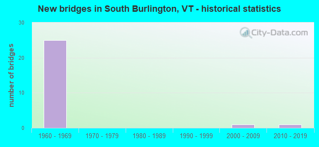
- New bridges - historical statistics
- 251960-1969
- 12000-2009
- 12010-2019

- Reconstructed bridges - Historical Statistics
- 11980-1989
- 51990-1999


- Bridge Condition - Deck
- 18.8%Very good
- 50.0%Good
- 31.3%Satisfactory

- Bridge Condition - Superstructure
- 18.8%Very good
- 62.5%Good
- 18.8%Satisfactory

- Bridge Condition - Substructure
- 12.5%Very good
- 68.8%Good
- 18.8%Satisfactory

- Bridge Condition - Channel
- 75.0%Very good
- 25.0%Good
Find on map >> Show street view
Structure Number: 200021000601032, Location: 2.7 MI S JCT. VT.17 W (Lat: 44.093833, Lng: -73.090947), Route carried "on" structure: State highway 116, Year Built: 2015, Status: Open, Structure Length: 1.52m (4.99ft), Average Daily Traffic: 2,500 (year 2018), Truck Traffic: 9%, Average Future Daily Traffic: 2,625 (year 2028), Design Load: HL 93, Features Intersected: NOTCH BROOK
Minimum Vertical Clearance: 30+ m (98+ ft), Kilometerpoint: 15.429, Lanes on structure: 2, Base Highway Network: Yes, Owner: State Highway Agency, Approaching Roadway Width: 9.8m (32.2ft), Skew: 2 degrees, Material/Design: Prestressed concrete, Design/Construction: Slab, Number Of Spans In Main Unit: 1, Length of Maximum Span: 14.6m (47.9ft), Curb-To-Curb Width: 9.8m (32.2ft), Out-to-Out Width: 10.7m (35.1ft)
Condition: Deck: Very good, Superstructure: Very good, Substructure: Very good, Channel: Good, Operating Rating: 52.6 metric tons, Method Used To Determine Operating Rating: Load and Resistance Factor (LRFR), Inventory Rating: 40.8 metric tons, Method Used To Determine Inventory Rating: Load and Resistance Factor (LRFR), Structural Evaluation: Equal to present desirable criteria, Deck Geometry: Meets minimum limits, Waterway Adequacy: Better than present minimum criteria, Approach Roadway Alignment: Equal to present desirable criteria, Designated Inspection Frequency: Every 24 months, Inspection Date: May 2021, Deck Structure Type: Concrete Precast Panels, Wearing Surface/Protective System: Wearing Surface: Bituminous, Membrane: Preformed Fabric
Find on map >> Show street view
Structure Number: 200021003104142, Location: 1.1 MI S JCT. U.S.2 (Lat: 44.448003, Lng: -73.157728), Route carried "on" structure: State highway 116, Year Built: 1963, Status: Open, Structure Length: 7.19m (23.59ft), Average Daily Traffic: 5,900 (year 2018), Truck Traffic: 9%, Average Future Daily Traffic: 6,195 (year 2028), Features Intersected: I 89 UNDER VT 116
Minimum Vertical Clearance: 30+ m (98+ ft), Kilometerpoint: 63.251, Lanes on structure: 2, Lanes under structure: 4, Base Highway Network: Yes, Owner: State Highway Agency, Approaching Roadway Width: 10.1m (33.1ft), Skew: 1 degrees, Material/Design: Steel, Design/Construction: Stringer/Multi-beam, Number Of Spans In Main Unit: 4, Length of Maximum Span: 19.8m (65.0ft), Curb or Sidewalk Widths: Left: 0.2m (0.7ft), Right: 0.2m (0.7ft), Curb-To-Curb Width: 9.1m (29.9ft), Out-to-Out Width: 10.7m (35.1ft)
Condition: Deck: Satisfactory, Superstructure: Good, Substructure: Good, Operating Rating: 85.3 metric tons, Method Used To Determine Operating Rating: Load Factor (LF), Inventory Rating: 50.8 metric tons, Method Used To Determine Inventory Rating: Load Factor (LF), Structural Evaluation: Better than present minimum criteria, Deck Geometry: Meets minimum limits, Underclear: Somewhat better than minimum adequacy, Approach Roadway Alignment: Equal to present desirable criteria, Designated Inspection Frequency: Every 24 months, Inspection Date: June 2020, Deck Structure Type: Concrete Cast-file-Place, Wearing Surface/Protective System: Wearing Surface: Bituminous, Membrane: Preformed Fabric
Find on map >> Show street view
Structure Number: 200089065N04142, Location: DORSET STREET (Lat: 44.449844, Lng: -73.178125), Route carried "on" structure: Interstate 89, Year Built: 1963, Status: Open, Structure Length: 5.09m (16.70ft), Average Daily Traffic: 41,000 (year 2018), Truck Traffic: 8%, Average Future Daily Traffic: 43,050 (year 2028), Design Load: HS 20, Features Intersected: I 89 OVER DORSET ST
Minimum Vertical Clearance: 30+ m (98+ ft), Kilometerpoint: 140.321, Lanes on structure: 2, Lanes under structure: 2, Base Highway Network: Yes, Owner: State Highway Agency, Approaching Roadway Width: 11.6m (38.1ft), Skew: 12 degrees, Material/Design: Steel, Design/Construction: Stringer/Multi-beam, Number Of Spans In Main Unit: 3, Length of Maximum Span: 23.5m (77.1ft), Curb or Sidewalk Widths: Left: 0.2m (0.7ft), Right: 0.2m (0.7ft), Curb-To-Curb Width: 9.1m (29.9ft), Out-to-Out Width: 10.7m (35.1ft)
Condition: Deck: Good, Superstructure: Good, Substructure: Good, Operating Rating: 64.4 metric tons, Method Used To Determine Operating Rating: Load Factor (LF), Inventory Rating: 38.1 metric tons, Method Used To Determine Inventory Rating: Load Factor (LF), Structural Evaluation: Better than present minimum criteria, Deck Geometry: High priority of replacement, Underclear: Equal to present minimum criteria, Approach Roadway Alignment: Equal to present desirable criteria, Length Of Structure Improvement: 5.09m (16.70ft), Designated Inspection Frequency: Every 24 months, Inspection Date: June 2020, Bridge Improvement Cost: $2,046,000, Roadway Improvement Cost: $50,000, Total Project Cost: $2,096,000 ( Estimate for 2020), Deck Structure Type: Concrete Cast-file-Place, Wearing Surface/Protective System: Wearing Surface: Bituminous, Membrane: Preformed Fabric
Find on map >> Show street view
Structure Number: 200089065S04142, Location: DORSET STREET (Lat: 44.449592, Lng: -73.178119), Route carried "on" structure: Interstate 89, Year Built: 1963, Status: Open, Structure Length: 5.09m (16.70ft), Average Daily Traffic: 41,000 (year 2018), Truck Traffic: 8%, Average Future Daily Traffic: 43,050 (year 2028), Design Load: HS 20, Features Intersected: I 89 OVER DORSET ST
Minimum Vertical Clearance: 30+ m (98+ ft), Kilometerpoint: 140.313, Lanes on structure: 3, Lanes under structure: 2, Base Highway Network: Yes, Owner: State Highway Agency, Approaching Roadway Width: 13.4m (44.0ft), Skew: 12 degrees, Material/Design: Steel, Design/Construction: Stringer/Multi-beam, Number Of Spans In Main Unit: 3, Length of Maximum Span: 23.5m (77.1ft), Curb or Sidewalk Widths: Left: 0.2m (0.7ft), Right: 0.2m (0.7ft), Curb-To-Curb Width: 12.8m (42.0ft), Out-to-Out Width: 14.3m (46.9ft)
Condition: Deck: Satisfactory, Superstructure: Good, Substructure: Good, Operating Rating: 69.9 metric tons, Method Used To Determine Operating Rating: Load Factor (LF), Inventory Rating: 41.7 metric tons, Method Used To Determine Inventory Rating: Load Factor (LF), Structural Evaluation: Better than present minimum criteria, Deck Geometry: High priority of replacement, Underclear: Better than present minimum criteria, Approach Roadway Alignment: Equal to present desirable criteria, Length Of Structure Improvement: 5.09m (16.70ft), Designated Inspection Frequency: Every 24 months, Inspection Date: June 2020, Bridge Improvement Cost: $2,747,000, Roadway Improvement Cost: $50,000, Total Project Cost: $2,797,000 ( Estimate for 2020), Deck Structure Type: Concrete Cast-file-Place, Wearing Surface/Protective System: Wearing Surface: Bituminous, Membrane: Preformed Fabric
Find on map >> Show street view
Structure Number: 200089066N04142, Location: EXIT 13 I 89-I 189 INTERS (Lat: 44.451411, Lng: -73.181222), Route carried "on" structure: Interstate 89, Year Built: 1962, Status: Open, Structure Length: 5.33m (17.49ft), Average Daily Traffic: 41,000 (year 2018), Truck Traffic: 8%, Average Future Daily Traffic: 43,050 (year 2028), Design Load: HS 20, Features Intersected: I 89 OVER EB I189
Minimum Vertical Clearance: 30+ m (98+ ft), Kilometerpoint: 140.611, Lanes on structure: 2, Lanes under structure: 2, Base Highway Network: Yes, Owner: State Highway Agency, Approaching Roadway Width: 11.6m (38.1ft), Skew: 10 degrees, Material/Design: Steel, Design/Construction: Stringer/Multi-beam, Number Of Spans In Main Unit: 3, Length of Maximum Span: 26.8m (87.9ft), Curb or Sidewalk Widths: Left: 0.2m (0.7ft), Right: 0.2m (0.7ft), Curb-To-Curb Width: 9.1m (29.9ft), Out-to-Out Width: 10.7m (35.1ft)
Condition: Deck: Good, Superstructure: Good, Substructure: Satisfactory, Operating Rating: 60.8 metric tons, Method Used To Determine Operating Rating: Load Factor (LF), Inventory Rating: 36.3 metric tons, Method Used To Determine Inventory Rating: Load Factor (LF), Structural Evaluation: Equal to present minimum criteria, Deck Geometry: High priority of replacement, Underclear: Meets minimum limits, Approach Roadway Alignment: Equal to present desirable criteria, Length Of Structure Improvement: 5.33m (17.49ft), Designated Inspection Frequency: Every 24 months, Inspection Date: June 2020, Bridge Improvement Cost: $2,144,000, Roadway Improvement Cost: $50,000, Total Project Cost: $2,194,000 ( Estimate for 2020), Deck Structure Type: Concrete Cast-file-Place, Wearing Surface/Protective System: Wearing Surface: Bituminous, Membrane: Preformed Fabric
Find on map >> Show street view
Structure Number: 200089066S04142, Location: EXIT 13 I 89-I 189 INTERS (Lat: 44.451300, Lng: -73.181442), Route carried "on" structure: Interstate 89, Year Built: 1962, Status: Open, Structure Length: 5.15m (16.90ft), Average Daily Traffic: 41,000 (year 2018), Truck Traffic: 8%, Average Future Daily Traffic: 43,050 (year 2028), Design Load: HS 20, Features Intersected: I 89 OVER EB I189
Minimum Vertical Clearance: 30+ m (98+ ft), Kilometerpoint: 140.611, Lanes on structure: 2, Lanes under structure: 2, Base Highway Network: Yes, Owner: State Highway Agency, Approaching Roadway Width: 11.6m (38.1ft), Skew: 10 degrees, Material/Design: Steel, Design/Construction: Stringer/Multi-beam, Number Of Spans In Main Unit: 3, Length of Maximum Span: 26.2m (86.0ft), Curb or Sidewalk Widths: Left: 0.2m (0.7ft), Right: 0.2m (0.7ft), Curb-To-Curb Width: 9.1m (29.9ft), Out-to-Out Width: 10.7m (35.1ft)
Condition: Deck: Good, Superstructure: Good, Substructure: Good, Operating Rating: 60.8 metric tons, Method Used To Determine Operating Rating: Load Factor (LF), Inventory Rating: 36.3 metric tons, Method Used To Determine Inventory Rating: Load Factor (LF), Structural Evaluation: Better than present minimum criteria, Deck Geometry: High priority of replacement, Underclear: Better than present minimum criteria, Approach Roadway Alignment: Equal to present desirable criteria, Length Of Structure Improvement: 5.15m (16.90ft), Designated Inspection Frequency: Every 24 months, Inspection Date: June 2020, Bridge Improvement Cost: $2,070,000, Roadway Improvement Cost: $50,000, Total Project Cost: $2,120,000 ( Estimate for 2020), Deck Structure Type: Concrete Cast-file-Place, Wearing Surface/Protective System: Wearing Surface: Bituminous, Membrane: Preformed Fabric
Find on map >> Show street view
Structure Number: 200089067E04142, Location: 0.1 MI E EXIT 13 I 89 (Lat: 44.452636, Lng: -73.180461), Route carried "on" structure: Ramp Interstate 89, Year Built: 1963, Status: Open, Structure Length: 5.09m (16.70ft), Average Daily Traffic: 41,000 (year 2018), Truck Traffic: 8%, Average Future Daily Traffic: 43,050 (year 2028), Design Load: HS 20, Features Intersected: RAMP E OVER RAMP D
Minimum Vertical Clearance: 30+ m (98+ ft), Kilometerpoint: 140.691, Lanes on structure: 1, Lanes under structure: 1, Base Highway Network: Yes, Owner: State Highway Agency, Approaching Roadway Width: 9.1m (29.9ft), Skew: 11 degrees, Material/Design: Steel, Design/Construction: Stringer/Multi-beam, Number Of Spans In Main Unit: 3, Length of Maximum Span: 21.9m (71.9ft), Curb or Sidewalk Widths: Left: 0.2m (0.7ft), Right: 0.2m (0.7ft), Curb-To-Curb Width: 6.7m (22.0ft), Out-to-Out Width: 8.2m (26.9ft)
Condition: Deck: Satisfactory, Superstructure: Good, Substructure: Good, Operating Rating: 68.0 metric tons, Method Used To Determine Operating Rating: Load Factor (LF), Inventory Rating: 40.8 metric tons, Method Used To Determine Inventory Rating: Load Factor (LF), Structural Evaluation: Better than present minimum criteria, Deck Geometry: Equal to present minimum criteria, Underclear: Somewhat better than minimum adequacy, Approach Roadway Alignment: Equal to present desirable criteria, Designated Inspection Frequency: Every 24 months, Inspection Date: June 2020, Deck Structure Type: Concrete Cast-file-Place, Wearing Surface/Protective System: Wearing Surface: Bituminous, Membrane: Preformed Fabric
Find on map >> Show street view
Structure Number: 200089070N04142, Location: 1.3 MI N EXIT 14 (Lat: 44.486353, Lng: -73.173531), Route carried "on" structure: Interstate 89, Year Built: 1962, Year Reconstructed: 1990, Status: Open, Structure Length: 30.97m (101.61ft), Average Daily Traffic: 56,400 (year 2018), Truck Traffic: 8%, Average Future Daily Traffic: 59,220 (year 2028), Design Load: HS 20+Mod, Features Intersected: WINOOSKI RIVER
Minimum Vertical Clearance: 30+ m (98+ ft), Kilometerpoint: 144.810, Lanes on structure: 3, Base Highway Network: Yes, Owner: State Highway Agency, Approaching Roadway Width: 16.2m (53.1ft), Skew: 14 degrees, Material/Design: Steel continuous, Design/Construction: Stringer/Multi-beam, Number Of Spans In Main Unit: 7, Length of Maximum Span: 43.3m (142.1ft), Curb or Sidewalk Widths: Left: 0.2m (0.7ft), Right: 0.2m (0.7ft), Curb-To-Curb Width: 14.8m (48.6ft), Out-to-Out Width: 16.2m (53.1ft)
Condition: Deck: Very good, Superstructure: Very good, Substructure: Good, Channel: Very good, Operating Rating: 89.8 metric tons, Method Used To Determine Operating Rating: Load Factor (LF), Inventory Rating: 57.2 metric tons, Method Used To Determine Inventory Rating: Load Factor (LF), Structural Evaluation: Better than present minimum criteria, Deck Geometry: Meets minimum limits, Waterway Adequacy: Equal to present desirable criteria, Approach Roadway Alignment: Equal to present desirable criteria, Designated Inspection Frequency: Every 24 months, Inspection Date: June 2020, Deck Structure Type: Concrete Cast-file-Place, Wearing Surface/Protective System: Wearing Surface: Bituminous, Membrane: Preformed Fabric, Deck Protection: Epoxy Coated Reinforcing
Find on map >> Show street view
Structure Number: 200089070S04142, Location: 1.3 MI N EXIT 14 (Lat: 44.486378, Lng: -73.173856), Route carried "on" structure: Interstate 89, Year Built: 1962, Year Reconstructed: 1990, Status: Open, Structure Length: 30.97m (101.61ft), Average Daily Traffic: 56,400 (year 2018), Truck Traffic: 8%, Average Future Daily Traffic: 59,220 (year 2028), Design Load: HS 20+Mod, Features Intersected: WINOOSKI RIVER
Minimum Vertical Clearance: 30+ m (98+ ft), Kilometerpoint: 144.810, Lanes on structure: 3, Base Highway Network: Yes, Owner: State Highway Agency, Approaching Roadway Width: 16.2m (53.1ft), Skew: 14 degrees, Material/Design: Steel continuous, Design/Construction: Stringer/Multi-beam, Number Of Spans In Main Unit: 7, Length of Maximum Span: 43.3m (142.1ft), Curb or Sidewalk Widths: Left: 0.2m (0.7ft), Right: 0.2m (0.7ft), Curb-To-Curb Width: 14.8m (48.6ft), Out-to-Out Width: 16.2m (53.1ft)
Condition: Deck: Good, Superstructure: Good, Substructure: Good, Channel: Very good, Operating Rating: 89.8 metric tons, Method Used To Determine Operating Rating: Load Factor (LF), Inventory Rating: 57.2 metric tons, Method Used To Determine Inventory Rating: Load Factor (LF), Structural Evaluation: Better than present minimum criteria, Deck Geometry: Meets minimum limits, Waterway Adequacy: Equal to present desirable criteria, Approach Roadway Alignment: Equal to present desirable criteria, Designated Inspection Frequency: Every 24 months, Inspection Date: June 2020, Deck Structure Type: Concrete Cast-file-Place, Wearing Surface/Protective System: Wearing Surface: Bituminous, Membrane: Preformed Fabric, Deck Protection: Epoxy Coated Reinforcing
Find on map >> Show street view
Structure Number: 200189002W04142, Location: 1.1 MI W JCT.I89 EXIT 13 (Lat: 44.448486, Lng: -73.204172), Route carried "on" structure: Spur Interstate 189, Year Built: 1962, Year Reconstructed: 1988, Status: Open, Structure Length: 2.10m (6.89ft), Average Daily Traffic: 36,800 (year 2018), Truck Traffic: 8%, Average Future Daily Traffic: 38,640 (year 2028), Design Load: HS 20, Features Intersected: I 189 OVER FARRELL
Minimum Vertical Clearance: 30+ m (98+ ft), Kilometerpoint: 0.434, Lanes on structure: 3, Lanes under structure: 2, Base Highway Network: Yes, Owner: State Highway Agency, Approaching Roadway Width: 13.4m (44.0ft), Skew: 12 degrees, Material/Design: Steel, Design/Construction: Stringer/Multi-beam, Number Of Spans In Main Unit: 1, Length of Maximum Span: 20.4m (66.9ft), Curb or Sidewalk Widths: Left: 0.2m (0.7ft), Right: 0.2m (0.7ft), Curb-To-Curb Width: 13.2m (43.3ft), Out-to-Out Width: 14.6m (47.9ft)
Condition: Deck: Satisfactory, Superstructure: Satisfactory, Substructure: Satisfactory, Operating Rating: 86.2 metric tons, Method Used To Determine Operating Rating: Load Factor (LF), Inventory Rating: 51.7 metric tons, Method Used To Determine Inventory Rating: Load Factor (LF), Structural Evaluation: Equal to present minimum criteria, Deck Geometry: High priority of replacement, Underclear: High priority of corrective action, Approach Roadway Alignment: Equal to present desirable criteria, Length Of Structure Improvement: 2.10m (6.89ft), Designated Inspection Frequency: Every 24 months, Inspection Date: June 2020, Bridge Improvement Cost: $1,154,000, Roadway Improvement Cost: $50,000, Total Project Cost: $1,204,000 ( Estimate for 2020), Deck Structure Type: Concrete Cast-file-Place, Wearing Surface/Protective System: Wearing Surface: Bituminous
Find on map >> Show street view
Structure Number: 200189003E04142, Location: 0.3 MI W I89 EXIT 13 (Lat: 44.449953, Lng: -73.188367), Route carried "on" structure: Spur Interstate 189, Year Built: 1962, Year Reconstructed: 1996, Status: Open, Structure Length: 3.87m (12.70ft), Average Daily Traffic: 36,800 (year 2018), Truck Traffic: 8%, Average Future Daily Traffic: 38,640 (year 2028), Design Load: HS 20, Features Intersected: I 189 OVER SPEAR ST
Minimum Vertical Clearance: 30+ m (98+ ft), Kilometerpoint: 1.722, Lanes on structure: 2, Lanes under structure: 2, Base Highway Network: Yes, Owner: State Highway Agency, Approaching Roadway Width: 11.9m (39.0ft), Skew: 10 degrees, Material/Design: Steel, Design/Construction: Stringer/Multi-beam, Number Of Spans In Main Unit: 3, Length of Maximum Span: 14.3m (46.9ft), Curb or Sidewalk Widths: Left: 0.2m (0.7ft), Right: 0.2m (0.7ft), Curb-To-Curb Width: 11.6m (38.1ft), Out-to-Out Width: 13.1m (43.0ft)
Condition: Deck: Good, Superstructure: Satisfactory, Substructure: Good, Operating Rating: 63.5 metric tons, Method Used To Determine Operating Rating: Load Factor (LF), Inventory Rating: 38.1 metric tons, Method Used To Determine Inventory Rating: Load Factor (LF), Structural Evaluation: Equal to present minimum criteria, Deck Geometry: Equal to present minimum criteria, Underclear: High priority of corrective action, Approach Roadway Alignment: Equal to present desirable criteria, Designated Inspection Frequency: Every 24 months, Inspection Date: June 2020, Deck Structure Type: Concrete Cast-file-Place, Wearing Surface/Protective System: Wearing Surface: Bituminous, Membrane: Preformed Fabric
Find on map >> Show street view
Structure Number: 200189003W04142, Location: 0.3 MI W I89 EXIT 13 (Lat: 44.451794, Lng: -73.188700), Route carried "on" structure: Spur Interstate 189, Year Built: 1962, Year Reconstructed: 1996, Status: Open, Structure Length: 3.87m (12.70ft), Average Daily Traffic: 36,800 (year 2018), Truck Traffic: 8%, Average Future Daily Traffic: 38,640 (year 2028), Design Load: HS 20, Features Intersected: I 189 OVER SPEAR ST
Minimum Vertical Clearance: 30+ m (98+ ft), Kilometerpoint: 1.722, Lanes on structure: 2, Lanes under structure: 2, Base Highway Network: Yes, Owner: State Highway Agency, Approaching Roadway Width: 11.9m (39.0ft), Skew: 10 degrees, Material/Design: Steel, Design/Construction: Stringer/Multi-beam, Number Of Spans In Main Unit: 3, Length of Maximum Span: 14.3m (46.9ft), Curb or Sidewalk Widths: Left: 0.2m (0.7ft), Right: 0.2m (0.7ft), Curb-To-Curb Width: 11.6m (38.1ft), Out-to-Out Width: 13.1m (43.0ft)
Condition: Deck: Good, Superstructure: Satisfactory, Substructure: Good, Operating Rating: 63.5 metric tons, Method Used To Determine Operating Rating: Load Factor (LF), Inventory Rating: 38.1 metric tons, Method Used To Determine Inventory Rating: Load Factor (LF), Structural Evaluation: Equal to present minimum criteria, Deck Geometry: Equal to present minimum criteria, Underclear: High priority of corrective action, Approach Roadway Alignment: Equal to present desirable criteria, Designated Inspection Frequency: Every 24 months, Inspection Date: June 2020, Deck Structure Type: Concrete Cast-file-Place, Wearing Surface/Protective System: Wearing Surface: Bituminous, Membrane: Preformed Fabric
Find on map >> Show street view
Structure Number: 200189004W04142, Location: I 89 EXIT 13 (Lat: 44.452314, Lng: -73.182358), Route carried "on" structure: Spur Interstate 189, Year Built: 1962, Status: Open, Structure Length: 8.11m (26.61ft), Average Daily Traffic: 36,800 (year 2018), Truck Traffic: 8%, Average Future Daily Traffic: 38,640 (year 2028), Design Load: HS 20, Features Intersected: I 189 WB OVER I 89
Minimum Vertical Clearance: 30+ m (98+ ft), Kilometerpoint: 2.317, Lanes on structure: 2, Lanes under structure: 4, Base Highway Network: Yes, Owner: State Highway Agency, Approaching Roadway Width: 11.6m (38.1ft), Skew: 12 degrees, Material/Design: Steel, Design/Construction: Stringer/Multi-beam, Number Of Spans In Main Unit: 4, Length of Maximum Span: 23.5m (77.1ft), Curb or Sidewalk Widths: Left: 0.2m (0.7ft), Right: 0.2m (0.7ft), Curb-To-Curb Width: 9.1m (29.9ft), Out-to-Out Width: 10.7m (35.1ft)
Condition: Deck: Good, Superstructure: Good, Substructure: Good, Operating Rating: 83.5 metric tons, Method Used To Determine Operating Rating: Load Factor (LF), Inventory Rating: 49.9 metric tons, Method Used To Determine Inventory Rating: Load Factor (LF), Structural Evaluation: Better than present minimum criteria, Deck Geometry: Meets minimum limits, Underclear: Equal to present minimum criteria, Approach Roadway Alignment: Equal to present desirable criteria, Length Of Structure Improvement: 8.11m (26.61ft), Designated Inspection Frequency: Every 24 months, Inspection Date: June 2020, Bridge Improvement Cost: $3,258,000, Roadway Improvement Cost: $50,000, Total Project Cost: $3,309,000 ( Estimate for 2020), Deck Structure Type: Concrete Cast-file-Place, Wearing Surface/Protective System: Wearing Surface: Bituminous, Membrane: Preformed Fabric
Find on map >> Show street view
Structure Number: 205200018C04142, Location: 1.1 MI E JCT. U.S.7 S (Lat: 44.470083, Lng: -73.184350), Route carried "on" structure: US 2, Year Built: 1962, Year Reconstructed: 2003, Status: Open, Structure Length: 7.96m (26.12ft), Average Daily Traffic: 33,300 (year 2018), Truck Traffic: 7%, Average Future Daily Traffic: 34,965 (year 2028), Design Load: HS 20, Features Intersected: I 89 UNDER US 2
Minimum Vertical Clearance: 30+ m (98+ ft), Kilometerpoint: 64.627, Lanes on structure: 6, Lanes under structure: 6, Base Highway Network: Yes (Inventory Route: 700000, Subroute: 1), Owner: State Highway Agency, Approaching Roadway Width: 23.8m (78.1ft), Skew: 20 degrees, Material/Design: Steel, Design/Construction: Stringer/Multi-beam, Number Of Spans In Main Unit: 4, Length of Maximum Span: 21.9m (71.9ft), Curb or Sidewalk Widths: Left: 1.8m (5.9ft), Right: 1.8m (5.9ft), Curb-To-Curb Width: 11.6m (38.1ft), Out-to-Out Width: 28.6m (93.8ft)
Condition: Deck: Good, Superstructure: Good, Substructure: Good, Operating Rating: 88.9 metric tons, Method Used To Determine Operating Rating: Load Factor (LF), Inventory Rating: 53.5 metric tons, Method Used To Determine Inventory Rating: Load Factor (LF), Structural Evaluation: Better than present minimum criteria, Deck Geometry: High priority of replacement, Underclear: Meets minimum limits, Approach Roadway Alignment: Equal to present desirable criteria, Length Of Structure Improvement: 7.96m (26.12ft), Designated Inspection Frequency: Every 24 months, Inspection Date: June 2020, Bridge Improvement Cost: $8,569,000, Roadway Improvement Cost: $50,000, Total Project Cost: $8,619,000 ( Estimate for 2020), Deck Structure Type: Concrete Cast-file-Place, Wearing Surface/Protective System: Wearing Surface: Bituminous, Membrane: Preformed Fabric, Deck Protection: Epoxy Coated Reinforcing
Find on map >> Show street view
Structure Number: 205206000604142, Location: 0.2 MI S JCT VT 15 ON TH4 (Lat: 44.490006, Lng: -73.162122), Route carried "on" structure: City street LIMKN, Year Built: 2006, Status: Open, Structure Length: 9.08m (29.79ft), Average Daily Traffic: 7,300 (year 2016), Truck Traffic: 3%, Average Future Daily Traffic: 7,665 (year 2026), Design Load: HS 25 or greater, Features Intersected: WINOOSKI RIVER & NECRR, Facility Carried by Structure: LIME KILN RD TH4
Minimum Vertical Clearance: 30+ m (98+ ft), Kilometerpoint: 0.000, Lanes on structure: 2, Owner: City or Municipal Highway Agency, Approaching Roadway Width: 12.8m (42.0ft), Material/Design: Concrete, Design/Construction: Arch - Deck, Number Of Spans In Main Unit: 1, Number Of Approach Spans: 2, Length of Maximum Span: 70.4m (231.0ft), Curb or Sidewalk Widths: Left: 0.2m (0.7ft), Right: 1.8m (5.9ft), Curb-To-Curb Width: 12.0m (39.4ft), Out-to-Out Width: 12.7m (41.7ft)
Condition: Deck: Very good, Superstructure: Very good, Substructure: Very good, Channel: Very good, Operating Rating: 83.5 metric tons, Method Used To Determine Operating Rating: Load Factor (LF), Inventory Rating: 53.5 metric tons, Method Used To Determine Inventory Rating: Load Factor (LF), Structural Evaluation: Equal to present desirable criteria, Deck Geometry: Somewhat better than minimum adequacy, Underclear: Somewhat better than minimum adequacy, Waterway Adequacy: Equal to present desirable criteria, Approach Roadway Alignment: Equal to present desirable criteria, Designated Inspection Frequency: Every 24 months, Inspection Date: July 2020, Deck Structure Type: Concrete Precast Panels, Wearing Surface/Protective System: Wearing Surface: Bituminous, Membrane: Preformed Fabric, Deck Protection: Epoxy Coated Reinforcing
Find on map >> Show street view
Structure Number: 205216001B04142, Location: PATCHEN ROAD (Lat: 44.478725, Lng: -73.176853), Route carried "on" structure: City street PATCH, Year Built: 1962, Status: Open, Structure Length: 7.80m (25.59ft), Average Daily Traffic: 6,800 (year 2016), Truck Traffic: 3%, Average Future Daily Traffic: 7,140 (year 2026), Design Load: H 20, Features Intersected: PATCHEN RD OVER I 89
Minimum Vertical Clearance: 30+ m (98+ ft), Kilometerpoint: 0.000, Lanes on structure: 2, Lanes under structure: 4, Owner: State Highway Agency, Approaching Roadway Width: 12.8m (42.0ft), Skew: 1 degrees, Material/Design: Steel, Design/Construction: Stringer/Multi-beam, Number Of Spans In Main Unit: 4, Length of Maximum Span: 23.5m (77.1ft), Curb or Sidewalk Widths: Left: 1.5m (4.9ft), Right: 1.5m (4.9ft), Curb-To-Curb Width: 9.1m (29.9ft), Out-to-Out Width: 12.8m (42.0ft)
Condition: Deck: Satisfactory, Superstructure: Good, Substructure: Satisfactory, Operating Rating: 81.6 metric tons, Method Used To Determine Operating Rating: Load Factor (LF), Inventory Rating: 49.0 metric tons, Method Used To Determine Inventory Rating: Load Factor (LF), Structural Evaluation: Equal to present minimum criteria, Deck Geometry: Meets minimum limits, Underclear: Better than present minimum criteria, Approach Roadway Alignment: Equal to present desirable criteria, Designated Inspection Frequency: Every 24 months, Inspection Date: June 2020, Deck Structure Type: Concrete Cast-file-Place, Wearing Surface/Protective System: Wearing Surface: Bituminous, Membrane: Preformed Fabric
Find on map >> Show street view
Structure Number: 200021003104142, Location: 1.1 MI S JCT. U.S.2 (Lat: 44.448003, Lng: -73.157728), Route carried "under" structure: Interstate 89, Year Built: 1963, Structure Length: 0. m, Average Daily Traffic: 32,200 (year 1998), Truck Traffic: 8%, Features Intersected: I 89 UNDER VT 116, Facility Carried by Structure: VT 00116 ML
Minimum Vertical Clearance: 5.33m (17.49ft), Kilometerpoint: 138.648, Lanes on structure: 2, Material/Design: Steel, Design/Construction: Stringer/Multi-beam, Length of Maximum Span: 19.8m (65.0ft)
Find on map >> Show street view
Structure Number: 200089065N04142, Location: DORSET STREET (Lat: 44.449844, Lng: -73.178125), Route carried "under" structure: City street DRSET, Year Built: 1963, Structure Length: 0. m, Average Daily Traffic: 8,000 (year 1997), Truck Traffic: 7%, Features Intersected: I 89 OVER DORSET ST, Facility Carried by Structure: I 00089 ML
Minimum Vertical Clearance: 4.69m (15.39ft), Kilometerpoint: 0.000, Lanes on structure: 2, Material/Design: Steel, Design/Construction: Stringer/Multi-beam, Length of Maximum Span: 23.5m (77.1ft)
Find on map >> Show street view
Structure Number: 200089065S04142, Location: DORSET STREET (Lat: 44.449592, Lng: -73.178119), Route carried "under" structure: City street DRSET, Year Built: 1963, Structure Length: 0. m, Average Daily Traffic: 8,000 (year 1997), Truck Traffic: 7%, Features Intersected: I 89 OVER DORSET ST, Facility Carried by Structure: I 00089 ML
Minimum Vertical Clearance: 4.92m (16.14ft), Kilometerpoint: 0.000, Lanes on structure: 2, Material/Design: Steel, Design/Construction: Stringer/Multi-beam, Length of Maximum Span: 23.5m (77.1ft)
Find on map >> Show street view
Structure Number: 200089066N04142, Location: EXIT 13 I 89-I 189 INTERS (Lat: 44.451411, Lng: -73.181222), Route carried "under" structure: Spur Interstate 189, Year Built: 1962, Structure Length: 0. m, Average Daily Traffic: 19,550 (year 1998), Truck Traffic: 8%, Features Intersected: I 89 OVER I 189, Facility Carried by Structure: I 00089 ML
Minimum Vertical Clearance: 5.41m (17.75ft), Kilometerpoint: 2.317, Lanes on structure: 2, Material/Design: Steel, Design/Construction: Stringer/Multi-beam, Length of Maximum Span: 26.8m (87.9ft)
Find on map >> Show street view
Structure Number: 200089066S04142, Location: EXIT 13 I 89-I 189 INTERS (Lat: 44.451300, Lng: -73.181442), Route carried "under" structure: Spur Interstate 189, Year Built: 1962, Structure Length: 0. m, Average Daily Traffic: 19,550 (year 1998), Truck Traffic: 8%, Features Intersected: I 89 OVER I 189, Facility Carried by Structure: I 00089 ML
Minimum Vertical Clearance: 5.84m (19.16ft), Kilometerpoint: 2.317, Lanes on structure: 2, Material/Design: Steel, Design/Construction: Stringer/Multi-beam, Length of Maximum Span: 26.8m (87.9ft)
Find on map >> Show street view
Structure Number: 200089067E04142, Location: 0.1 MI E EXIT 13 I 89 (Lat: 44.452636, Lng: -73.180461), Route carried "under" structure: Ramp Interstate 89, Year Built: 1963, Structure Length: 0. m, Average Daily Traffic: 6,300 (year 1998), Truck Traffic: 8%, Features Intersected: RAMP D UNDER RAMP E
Minimum Vertical Clearance: 5.30m (17.39ft), Kilometerpoint: 140.691, Lanes on structure: 1, Material/Design: Steel, Design/Construction: Stringer/Multi-beam, Length of Maximum Span: 21.9m (71.9ft)
Find on map >> Show street view
Structure Number: 200189003E04142, Location: 0.3 MI W I89 EXIT 13 (Lat: 44.449953, Lng: -73.188367), Route carried "under" structure: City street SPEAR, Year Built: 1962, Structure Length: 0. m, Average Daily Traffic: 5,300 (year 1997), Truck Traffic: 7%, Features Intersected: I 189 OVER SPEAR ST, Facility Carried by Structure: I 00189 SPUR
Minimum Vertical Clearance: 4.34m (14.24ft), Kilometerpoint: 0.000, Lanes on structure: 2, Material/Design: Steel, Design/Construction: Stringer/Multi-beam, Length of Maximum Span: 14.3m (46.9ft)
Find on map >> Show street view
Structure Number: 200189003W04142, Location: 0.3 MI W I89 EXIT 13 (Lat: 44.451794, Lng: -73.188700), Route carried "under" structure: City street SPEAR, Year Built: 1962, Structure Length: 0. m, Average Daily Traffic: 5,300 (year 1997), Truck Traffic: 7%, Features Intersected: I 189 OVER SPEAR ST, Facility Carried by Structure: I 00189 SPUR
Minimum Vertical Clearance: 4.29m (14.07ft), Kilometerpoint: 0.000, Lanes on structure: 2, Material/Design: Steel, Design/Construction: Stringer/Multi-beam, Length of Maximum Span: 14.3m (46.9ft)
Find on map >> Show street view
Structure Number: 200189004W04142, Location: I 89 EXIT 13 (Lat: 44.452314, Lng: -73.182358), Route carried "under" structure: Interstate 89, Year Built: 1962, Structure Length: 0. m, Average Daily Traffic: 35,050 (year 1998), Truck Traffic: 8%, Features Intersected: I 89 UNDER I 189 WB
Minimum Vertical Clearance: 5.56m (18.24ft), Kilometerpoint: 140.771, Lanes on structure: 2, Material/Design: Steel, Design/Construction: Stringer/Multi-beam, Length of Maximum Span: 23.5m (77.1ft)
Find on map >> Show street view
Structure Number: 205200018C04142, Location: 1.1 MI E JCT. U.S.7 S (Lat: 44.470083, Lng: -73.184350), Route carried "under" structure: Interstate 89, Year Built: 1962, Structure Length: 0. m, Average Daily Traffic: 43,500 (year 1998), Truck Traffic: 8%, Features Intersected: I 89 UNDER US 2, Facility Carried by Structure: US 00002 ML
Minimum Vertical Clearance: 4.92m (16.14ft), Kilometerpoint: 142.767, Lanes on structure: 2, Material/Design: Steel, Design/Construction: Stringer/Multi-beam, Length of Maximum Span: 21.9m (71.9ft)
Find on map >> Show street view
Structure Number: 205216001B04142, Location: PATCHEN ROAD (Lat: 44.478725, Lng: -73.176853), Route carried "under" structure: Interstate 89, Year Built: 1962, Structure Length: 0. m, Average Daily Traffic: 49,100 (year 1998), Truck Traffic: 8%, Features Intersected: I 89 UNDER PATCHEN RD, Facility Carried by Structure: CITY PATCH
Minimum Vertical Clearance: 5.81m (19.06ft), Kilometerpoint: 143.909, Lanes on structure: 2, Material/Design: Steel, Design/Construction: Stringer/Multi-beam, Length of Maximum Span: 23.5m (77.1ft)