Bridge Statistics for South Hempstead, New York (NY)
Condition, Traffic, Stress, Structural Evaluation, Project Costs
- National Bridge Inventory (NBI) Statistics
- 12Number of bridges
- 39ft / 12.1mTotal length
- $24,836,000Total costs
- 984,406Total average daily traffic
- 1,436Total average daily truck traffic
- National Bridge Inventory (NBI) Registered Bridges for South Hempstead
- No street view available for this location
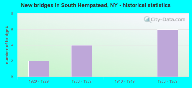
- New bridges - historical statistics
- 21920-1929
- 41930-1939
- 61950-1959

- Reconstructed bridges - Historical Statistics
- 21970-1979
- 01980-1989
- 01990-1999
- 12000-2009


- Bridge Condition - Superstructure
- 16.7%Good
- 66.7%Satisfactory
- 16.7%Fair

- Bridge Condition - Substructure
- 83.3%Good
- 16.7%Satisfactory
Find on map >> Show street view
Structure Number: 105947, Location: 5.5 MI W JCT SSP + WSP (Lat: 40.687708, Lng: -73.624119), Route carried "on" structure: County highway , Year Built: 1956, Status: Open, Structure Length: 2.23m (7.32ft), Average Daily Traffic: 6,334 (year 2018), Truck Traffic: 3%, Average Future Daily Traffic: 7,694 (year 2040), Design Load: HS 20, Features Intersected: RTE 908M, Facility Carried by Structure: HEMP-FRANKLIN AVE
Minimum Vertical Clearance: 30+ m (98+ ft), Kilometerpoint: 3.636, Lanes on structure: 2, Lanes under structure: 3, Owner: State Highway Agency, Approaching Roadway Width: 12.8m (42.0ft), Skew: 1 degrees, Material/Design: Concrete, Design/Construction: Arch - Deck, Number Of Spans In Main Unit: 1, Length of Maximum Span: 21.9m (71.9ft), Curb or Sidewalk Widths: Left: 2.7m (8.9ft), Right: 2.7m (8.9ft), Curb-To-Curb Width: 12.8m (42.0ft), Out-to-Out Width: 19.5m (64.0ft)
Condition: Superstructure: Satisfactory, Substructure: Good, Operating Rating: 88.2 metric tons, Method Used To Determine Operating Rating: Field evaluation and documented engineering judgment, Inventory Rating: 32.7 metric tons, Method Used To Determine Inventory Rating: Field evaluation and documented engineering judgment, Structural Evaluation: Equal to present minimum criteria, Deck Geometry: Somewhat better than minimum adequacy, Underclear: High priority of corrective action, Approach Roadway Alignment: Better than present minimum criteria, Length Of Structure Improvement: 2.22m (7.28ft), Designated Inspection Frequency: Every 24 months, Inspection Date: November 2020, Bridge Improvement Cost: $3,423,000, Roadway Improvement Cost: $2,004,000, Total Project Cost: $5,427,000 ( Estimate for 2021), Wearing Surface/Protective System: Wearing Surface: Bituminous, Membrane: Preformed Fabric
Find on map >> Show street view
Structure Number: 1059481, Location: 5.3 MI W JCT RTS SSP+WSP (Lat: 40.687572, Lng: -73.619942), Route carried "on" structure: State highway 908M, Year Built: 1930, Year Reconstructed: 1976, Status: Open, Structure Length: 1.68m (5.51ft), Average Daily Traffic: 87,316 (year 2020), Average Future Daily Traffic: 103,862 (year 2040), Features Intersected: LONG BEACH ROAD
Minimum Vertical Clearance: 30+ m (98+ ft), Kilometerpoint: 9.863, Lanes on structure: 3, Lanes under structure: 2, Base Highway Network: Yes, Owner: State Highway Agency, Approaching Roadway Width: 12.8m (42.0ft), Skew: 1 degrees, Material/Design: Concrete, Design/Construction: Frame, Number Of Spans In Main Unit: 1, Length of Maximum Span: 15.8m (51.8ft), Curb-To-Curb Width: 12.8m (42.0ft), Out-to-Out Width: 20.2m (66.3ft)
Condition: Deck: Satisfactory, Superstructure: Satisfactory, Substructure: Good, Operating Rating: 56.3 metric tons, Method Used To Determine Operating Rating: Field evaluation and documented engineering judgment, Inventory Rating: 22.9 metric tons, Method Used To Determine Inventory Rating: Field evaluation and documented engineering judgment, Structural Evaluation: Somewhat better than minimum adequacy, Deck Geometry: High priority of replacement, Underclear: Somewhat better than minimum adequacy, Approach Roadway Alignment: Equal to present desirable criteria, Length Of Structure Improvement: 1.67m (5.48ft), Designated Inspection Frequency: Every 24 months, Inspection Date: July 2021, Bridge Improvement Cost: $1,978,000, Roadway Improvement Cost: $1,158,000, Total Project Cost: $3,137,000 ( Estimate for 2021), Wearing Surface/Protective System: Wearing Surface: Bituminous, Membrane: Preformed Fabric
Find on map >> Show street view
Structure Number: 1059482, Location: 5.3 MI W JCT RTS SSP+WSP (Lat: 40.687369, Lng: -73.620044), Route carried "on" structure: State highway 908M, Year Built: 1956, Year Reconstructed: 1976, Status: Open, Structure Length: 1.77m (5.81ft), Average Daily Traffic: 87,316 (year 2020), Average Future Daily Traffic: 103,862 (year 2040), Design Load: HS 20, Features Intersected: LONG BEACH ROAD
Minimum Vertical Clearance: 30+ m (98+ ft), Kilometerpoint: 9.863, Lanes on structure: 3, Lanes under structure: 2, Base Highway Network: Yes, Owner: State Highway Agency, Approaching Roadway Width: 11.0m (36.1ft), Skew: 1 degrees, Material/Design: Concrete, Design/Construction: Frame, Number Of Spans In Main Unit: 1, Length of Maximum Span: 15.8m (51.8ft), Curb-To-Curb Width: 11.0m (36.1ft), Out-to-Out Width: 17.4m (57.1ft)
Condition: Deck: Satisfactory, Superstructure: Satisfactory, Substructure: Good, Operating Rating: 83.8 metric tons, Method Used To Determine Operating Rating: Field evaluation and documented engineering judgment, Inventory Rating: 32.7 metric tons, Method Used To Determine Inventory Rating: Field evaluation and documented engineering judgment, Structural Evaluation: Equal to present minimum criteria, Deck Geometry: High priority of replacement, Underclear: Somewhat better than minimum adequacy, Approach Roadway Alignment: Equal to present desirable criteria, Length Of Structure Improvement: 1.76m (5.77ft), Designated Inspection Frequency: Every 24 months, Inspection Date: July 2021, Bridge Improvement Cost: $1,891,000, Roadway Improvement Cost: $1,107,000, Total Project Cost: $2,998,000 ( Estimate for 2021), Wearing Surface/Protective System: Wearing Surface: Bituminous, Membrane: Preformed Fabric
Find on map >> Show street view
Structure Number: 1059509, Location: 5 MI W JCT SSP & WSP (Lat: 40.686897, Lng: -73.614597), Route carried "on" structure: County highway , Year Built: 1930, Status: Open, Structure Length: 2.10m (6.89ft), Average Daily Traffic: 26,410 (year 2019), Truck Traffic: 2%, Average Future Daily Traffic: 32,082 (year 2040), Features Intersected: RTE 908M, Facility Carried by Structure: BALDWIN ROAD
Minimum Vertical Clearance: 30+ m (98+ ft), Kilometerpoint: 5.567, Lanes on structure: 4, Lanes under structure: 4, Owner: State Highway Agency, Approaching Roadway Width: 12.2m (40.0ft), Skew: 1 degrees, Material/Design: Concrete, Design/Construction: Arch - Deck, Number Of Spans In Main Unit: 1, Length of Maximum Span: 20.7m (67.9ft), Curb or Sidewalk Widths: Left: 1.0m (3.3ft), Right: 1.2m (3.9ft), Curb-To-Curb Width: 12.2m (40.0ft), Out-to-Out Width: 16.2m (53.1ft)
Condition: Superstructure: Satisfactory, Substructure: Satisfactory, Operating Rating: 59.4 metric tons, Method Used To Determine Operating Rating: Field evaluation and documented engineering judgment, Inventory Rating: 23.2 metric tons, Method Used To Determine Inventory Rating: Field evaluation and documented engineering judgment, Structural Evaluation: Somewhat better than minimum adequacy, Deck Geometry: High priority of replacement, Underclear: High priority of corrective action, Approach Roadway Alignment: Equal to present desirable criteria, Length Of Structure Improvement: 2.10m (6.89ft), Designated Inspection Frequency: Every 24 months, Inspection Date: November 2020, Bridge Improvement Cost: $2,288,000, Roadway Improvement Cost: $1,340,000, Total Project Cost: $3,628,000 ( Estimate for 2021), Wearing Surface/Protective System: Wearing Surface: Bituminous, Membrane: Preformed Fabric
Find on map >> Show street view
Structure Number: 152023, Location: 5.5 MI W JCT SSP + WSP (Lat: 40.687981, Lng: -73.623953), Route carried "on" structure: County highway , Year Built: 1929, Year Reconstructed: 2014, Status: Open, Structure Length: 2.16m (7.09ft), Average Daily Traffic: 6,334 (year 2018), Truck Traffic: 3%, Average Future Daily Traffic: 7,694 (year 2040), Features Intersected: RTE 908M, Facility Carried by Structure: HEMP-FRANKLIN AVE
Minimum Vertical Clearance: 30+ m (98+ ft), Kilometerpoint: 3.685, Lanes on structure: 2, Lanes under structure: 3, Owner: State Highway Agency, Approaching Roadway Width: 12.8m (42.0ft), Skew: 1 degrees, Material/Design: Concrete, Design/Construction: Arch - Deck, Number Of Spans In Main Unit: 1, Length of Maximum Span: 20.4m (66.9ft), Curb or Sidewalk Widths: Left: 2.7m (8.9ft), Right: 2.7m (8.9ft), Curb-To-Curb Width: 12.8m (42.0ft), Out-to-Out Width: 19.5m (64.0ft)
Condition: Superstructure: Fair, Substructure: Good, Operating Rating: 40.0 metric tons, Method Used To Determine Operating Rating: Field evaluation and documented engineering judgment, Inventory Rating: 10.3 metric tons, Method Used To Determine Inventory Rating: Field evaluation and documented engineering judgment, Structural Evaluation: High priority of corrective action, Deck Geometry: Somewhat better than minimum adequacy, Underclear: High priority of corrective action, Approach Roadway Alignment: Equal to present desirable criteria, Length Of Structure Improvement: 2.16m (7.09ft), Designated Inspection Frequency: Every 24 months, Inspection Date: November 2020, Bridge Improvement Cost: $3,010,000, Roadway Improvement Cost: $1,762,000, Total Project Cost: $4,772,000 ( Estimate for 2021), Wearing Surface/Protective System: Wearing Surface: Bituminous, Membrane: Preformed Fabric
Find on map >> Show street view
Structure Number: 1520249, Location: 5 MI W JCT SSP + WSP (Lat: 40.687183, Lng: -73.614542), Route carried "on" structure: County highway , Year Built: 1957, Status: Open, Structure Length: 2.19m (7.19ft), Average Daily Traffic: 26,410 (year 2019), Truck Traffic: 2%, Average Future Daily Traffic: 32,082 (year 2040), Design Load: HS 20, Features Intersected: RTE 908M, Facility Carried by Structure: BALDWIN ROAD
Minimum Vertical Clearance: 30+ m (98+ ft), Kilometerpoint: 5.615, Lanes on structure: 4, Lanes under structure: 4, Owner: State Highway Agency, Approaching Roadway Width: 12.2m (40.0ft), Skew: 1 degrees, Material/Design: Concrete, Design/Construction: Arch - Deck, Number Of Spans In Main Unit: 1, Length of Maximum Span: 21.6m (70.9ft), Curb or Sidewalk Widths: Left: 1.1m (3.6ft), Right: 1.2m (3.9ft), Curb-To-Curb Width: 12.2m (40.0ft), Out-to-Out Width: 16.2m (53.1ft)
Condition: Superstructure: Good, Substructure: Good, Operating Rating: 88.0 metric tons, Method Used To Determine Operating Rating: Field evaluation and documented engineering judgment, Inventory Rating: 32.7 metric tons, Method Used To Determine Inventory Rating: Field evaluation and documented engineering judgment, Structural Evaluation: Better than present minimum criteria, Deck Geometry: High priority of replacement, Underclear: High priority of corrective action, Approach Roadway Alignment: Equal to present desirable criteria, Length Of Structure Improvement: 2.19m (7.19ft), Designated Inspection Frequency: Every 24 months, Inspection Date: November 2020, Bridge Improvement Cost: $3,074,000, Roadway Improvement Cost: $1,800,000, Total Project Cost: $4,874,000 ( Estimate for 2021), Wearing Surface/Protective System: Wearing Surface: Bituminous, Membrane: Preformed Fabric
Find on map >> Show street view
Structure Number: 105947, Location: 5.5 MI W JCT SSP + WSP (Lat: 40.687708, Lng: -73.624119), Route carried "under" structure: State highway 908M, Year Built: 1956, Structure Length: 0. m, Average Daily Traffic: 170,636 (year 2002), Features Intersected: RTE 908M, Facility Carried by Structure: HEMP-FRANKLIN AVE
Minimum Vertical Clearance: 4.01m (13.16ft), Kilometerpoint: 9.509, Lanes on structure: 2, Lanes under structure: 3, Material/Design: Concrete, Design/Construction: Arch - Deck, Length of Maximum Span: 21.9m (71.9ft)
Find on map >> Show street view
Structure Number: 1059481, Location: 5.3 MI W JCT RTS SSP+WSP (Lat: 40.687572, Lng: -73.619942), Route carried "under" structure: County highway , Year Built: 1930, Structure Length: 0. m, Average Daily Traffic: 8,309 (year 2001), Features Intersected: LONG BEACH ROAD, Facility Carried by Structure: RTE 908M
Minimum Vertical Clearance: 4.44m (14.57ft), Kilometerpoint: 0.000, Lanes on structure: 3, Lanes under structure: 2, Material/Design: Concrete, Design/Construction: Frame, Length of Maximum Span: 15.8m (51.8ft)
Find on map >> Show street view
Structure Number: 1059482, Location: 5.3 MI W JCT RTS SSP+WSP (Lat: 40.687369, Lng: -73.620044), Route carried "under" structure: County highway , Year Built: 1956, Structure Length: 0. m, Average Daily Traffic: 8,309 (year 2001), Features Intersected: LONG BEACH ROAD, Facility Carried by Structure: RTE 908M
Minimum Vertical Clearance: 4.37m (14.34ft), Kilometerpoint: 0.000, Lanes on structure: 3, Lanes under structure: 2, Material/Design: Concrete, Design/Construction: Frame, Length of Maximum Span: 15.8m (51.8ft)
Find on map >> Show street view
Structure Number: 1059509, Location: 5 MI W JCT SSP & WSP (Lat: 40.686897, Lng: -73.614597), Route carried "under" structure: State highway 908M, Year Built: 1930, Structure Length: 0. m, Average Daily Traffic: 193,198 (year 2002), Features Intersected: RTE 908M, Facility Carried by Structure: BALDWIN ROAD
Minimum Vertical Clearance: 3.84m (12.60ft), Kilometerpoint: 10.346, Lanes on structure: 4, Lanes under structure: 4, Material/Design: Concrete, Design/Construction: Arch - Deck, Length of Maximum Span: 20.7m (67.9ft)
Find on map >> Show street view
Structure Number: 152023, Location: 5.5 MI W JCT SSP + WSP (Lat: 40.687981, Lng: -73.623953), Route carried "under" structure: State highway 908M, Year Built: 1929, Structure Length: 0. m, Average Daily Traffic: 170,636 (year 2002), Features Intersected: RTE 908M, Facility Carried by Structure: HEMP-FRANKLIN AVE
Minimum Vertical Clearance: 3.76m (12.34ft), Kilometerpoint: 9.509, Lanes on structure: 2, Lanes under structure: 3, Material/Design: Concrete, Design/Construction: Arch - Deck, Length of Maximum Span: 20.4m (66.9ft)
Find on map >> Show street view
Structure Number: 1520249, Location: 5 MI W JCT SSP + WSP (Lat: 40.687183, Lng: -73.614542), Route carried "under" structure: State highway 908M, Year Built: 1957, Structure Length: 0. m, Average Daily Traffic: 193,198 (year 2002), Features Intersected: RTE 908M, Facility Carried by Structure: BALDWIN ROAD
Minimum Vertical Clearance: 4.09m (13.42ft), Kilometerpoint: 10.346, Lanes on structure: 4, Lanes under structure: 4, Material/Design: Concrete, Design/Construction: Arch - Deck, Length of Maximum Span: 21.6m (70.9ft)