Bridge Statistics for South Portland, Maine (ME)
Condition, Traffic, Stress, Structural Evaluation, Project Costs
- National Bridge Inventory (NBI) Statistics
- 36Number of bridges
- 1,040ft / 317mTotal length
- 504,479Total average daily traffic
- 41,288Total average daily truck traffic
- National Bridge Inventory (NBI) Registered Bridges for South Portland
- No street view available for this location
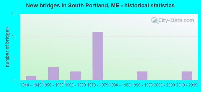
- New bridges - historical statistics
- 11940-1949
- 31950-1959
- 21960-1969
- 111970-1979
- 21990-1999
- 22010-2019

- Reconstructed bridges - Historical Statistics
- 41980-1989
- 51990-1999


- Bridge Condition - Deck
- 9.5%Very good
- 14.3%Good
- 47.6%Satisfactory
- 23.8%Fair
- 4.8%Poor

- Bridge Condition - Superstructure
- 9.5%Very good
- 33.3%Good
- 57.1%Satisfactory

- Bridge Condition - Substructure
- 9.5%Very good
- 19.0%Good
- 57.1%Satisfactory
- 14.3%Fair

- Bridge Condition - Channel
- 40.0%Good
- 60.0%Satisfactory
Find on map >> Show street view
Structure Number: 1376, Location: .5 MI S TOWNLINE (Lat: 43.638881, Lng: -70.294511), Route carried "on" structure: Ramp State highway 1, Year Built: 1974, Status: Open, Structure Length: 15.73m (51.61ft), Average Daily Traffic: 4,280 (year 2016), Truck Traffic: 10%, Average Future Daily Traffic: 5,992 (year 2036), Design Load: HS 20, Features Intersected: 295/NB RAMP 295 TO 1/PTR
Minimum Vertical Clearance: 30+ m (98+ ft), Kilometerpoint: 32.300, Lanes on structure: 2, Lanes under structure: 6, Owner: State Highway Agency, Approaching Roadway Width: 9.1m (29.9ft), Material/Design: Steel continuous, Design/Construction: Stringer/Multi-beam, Number Of Spans In Main Unit: 6, Length of Maximum Span: 30.5m (100.1ft), Curb or Sidewalk Widths: Left: 0.2m (0.7ft), Right: 0.2m (0.7ft), Curb-To-Curb Width: 9.4m (30.8ft), Out-to-Out Width: 10.6m (34.8ft)
Condition: Deck: Poor, Superstructure: Satisfactory, Substructure: Fair, Channel: Satisfactory, Operating Rating: 48.6 metric tons, Method Used To Determine Operating Rating: Load and Resistance Factor Rating (LRFR) rating reported by rating factor(RF) method using HL-93 loadings, Inventory Rating: 37.6 metric tons, Method Used To Determine Inventory Rating: Load and Resistance Factor Rating (LRFR) rating reported by rating factor(RF) method using HL-93 loadings, Structural Evaluation: Somewhat better than minimum adequacy, Deck Geometry: Somewhat better than minimum adequacy, Underclear: Meets minimum limits, Approach Roadway Alignment: Equal to present desirable criteria, Designated Inspection Frequency: Every 24 months, Inspection Date: August 2020, Deck Structure Type: Concrete Cast-file-Place, Wearing Surface/Protective System: Wearing Surface: Bituminous, Membrane: Preformed Fabric
Find on map >> Show street view
Structure Number: 1377, Location: .5 MI S TOWNLINE (Lat: 43.640531, Lng: -70.293019), Route carried "on" structure: State highway , Year Built: 1974, Status: Open, Structure Length: 12.77m (41.90ft), Average Daily Traffic: 11,240 (year 2016), Truck Traffic: 7%, Average Future Daily Traffic: 15,736 (year 2036), Design Load: HS 20, Features Intersected: I295 & NB US1 TO 295 NB, Facility Carried by Structure: US 1 SB
Minimum Vertical Clearance: 30+ m (98+ ft), Kilometerpoint: 1.110, Lanes on structure: 2, Lanes under structure: 5, Base Highway Network: Yes, Owner: State Highway Agency, Approaching Roadway Width: 12.2m (40.0ft), Skew: 4 degrees, Material/Design: Steel continuous, Design/Construction: Stringer/Multi-beam, Number Of Spans In Main Unit: 5, Length of Maximum Span: 29.9m (98.1ft), Curb or Sidewalk Widths: Left: 0.2m (0.7ft), Right: 0.2m (0.7ft), Curb-To-Curb Width: 11.9m (39.0ft), Out-to-Out Width: 13.1m (43.0ft)
Condition: Deck: Fair, Superstructure: Satisfactory, Substructure: Satisfactory, Operating Rating: 54.1 metric tons, Method Used To Determine Operating Rating: Load and Resistance Factor Rating (LRFR) rating reported by rating factor(RF) method using HL-93 loadings, Inventory Rating: 41.8 metric tons, Method Used To Determine Inventory Rating: Load and Resistance Factor Rating (LRFR) rating reported by rating factor(RF) method using HL-93 loadings, Structural Evaluation: Equal to present minimum criteria, Deck Geometry: Equal to present minimum criteria, Underclear: Meets minimum limits, Approach Roadway Alignment: Better than present minimum criteria, Designated Inspection Frequency: Every 24 months, Inspection Date: August 2021, Deck Structure Type: Concrete Cast-file-Place, Wearing Surface/Protective System: Wearing Surface: Bituminous, Membrane: Preformed Fabric
Find on map >> Show street view
Structure Number: 139, Location: 0.051 mi N of Spring St (Lat: 43.625961, Lng: -70.347100), Route carried "on" structure: Interstate 295, Year Built: 1972, Status: Open, Structure Length: 3.31m (10.86ft), Average Daily Traffic: 14,770 (year 2016), Truck Traffic: 10%, Average Future Daily Traffic: 20,678 (year 2036), Design Load: HL 93, Features Intersected: PAYNE ROAD (SB)
Minimum Vertical Clearance: 30+ m (98+ ft), Kilometerpoint: 84.249, Lanes on structure: 2, Lanes under structure: 5, Base Highway Network: Yes, Toll: On Interstate toll segment, Owner: State Toll Authority, Approaching Roadway Width: 12.4m (40.7ft), Skew: 3 degrees, Material/Design: Steel continuous, Design/Construction: Stringer/Multi-beam, Number Of Spans In Main Unit: 1, Length of Maximum Span: 33.1m (108.6ft), Curb or Sidewalk Widths: Left: 0.2m (0.7ft), Right: 0.2m (0.7ft), Curb-To-Curb Width: 12.4m (40.7ft), Out-to-Out Width: 13.6m (44.6ft)
Condition: Deck: Satisfactory, Superstructure: Satisfactory, Substructure: Satisfactory, Operating Rating: 51.8 metric tons, Method Used To Determine Operating Rating: Load and Resistance Factor Rating (LRFR) rating reported by rating factor(RF) method using HL-93 loadings, Inventory Rating: 39.9 metric tons, Method Used To Determine Inventory Rating: Load and Resistance Factor Rating (LRFR) rating reported by rating factor(RF) method using HL-93 loadings, Structural Evaluation: Equal to present minimum criteria, Deck Geometry: Better than present minimum criteria, Underclear: Somewhat better than minimum adequacy, Approach Roadway Alignment: Equal to present desirable criteria, Designated Inspection Frequency: Every 24 months, Inspection Date: April 2021, Deck Structure Type: Concrete Cast-file-Place, Wearing Surface/Protective System: Wearing Surface: Bituminous, Membrane: Preformed Fabric
Find on map >> Show street view
Structure Number: 1513, Location: 0.5 MI N RTE 1 CONN. (Lat: 43.626989, Lng: -70.329181), Route carried "on" structure: State highway 295, Year Built: 1971, Year Reconstructed: 1995, Status: Open, Structure Length: 7.17m (23.52ft), Average Daily Traffic: 14,770 (year 2016), Truck Traffic: 10%, Average Future Daily Traffic: 20,678 (year 2036), Design Load: HS 20+Mod, Features Intersected: STATE ROUTE 703
Minimum Vertical Clearance: 30+ m (98+ ft), Kilometerpoint: 82.736, Lanes on structure: 3, Lanes under structure: 4, Base Highway Network: Yes, Owner: State Highway Agency, Approaching Roadway Width: 12.2m (40.0ft), Skew: 5 degrees, Material/Design: Steel continuous, Design/Construction: Stringer/Multi-beam, Number Of Spans In Main Unit: 2, Length of Maximum Span: 36.5m (119.8ft), Curb or Sidewalk Widths: Left: 0.2m (0.7ft), Right: 0.2m (0.7ft), Curb-To-Curb Width: 12.8m (42.0ft), Out-to-Out Width: 13.7m (44.9ft)
Condition: Deck: Satisfactory, Superstructure: Good, Substructure: Good, Operating Rating: 46.7 metric tons, Method Used To Determine Operating Rating: Load and Resistance Factor Rating (LRFR) rating reported by rating factor(RF) method using HL-93 loadings, Inventory Rating: 36.0 metric tons, Method Used To Determine Inventory Rating: Load and Resistance Factor Rating (LRFR) rating reported by rating factor(RF) method using HL-93 loadings, Structural Evaluation: Better than present minimum criteria, Deck Geometry: Meets minimum limits, Underclear: Meets minimum limits, Approach Roadway Alignment: Equal to present desirable criteria, Designated Inspection Frequency: Every 24 months, Inspection Date: December 2021, Deck Structure Type: Concrete Cast-file-Place, Wearing Surface/Protective System: Wearing Surface: Bituminous, Membrane: Preformed Fabric
Find on map >> Show street view
Structure Number: 329, Location: 100 FT S OF JCT RTE 16 (Lat: 45.117439, Lng: -69.646419), Route carried "on" structure: City street , Year Built: 1941, Status: Open, Structure Length: 1.04m (3.41ft), Average Daily Traffic: 72 (year 2016), Truck Traffic: 5%, Average Future Daily Traffic: 115 (year 2036), Design Load: H 15, Features Intersected: KINGSBURY STREAM, Facility Carried by Structure: CAMPBELL RD
Minimum Vertical Clearance: 30+ m (98+ ft), Kilometerpoint: 5.182, Lanes on structure: 2, Owner: State Highway Agency, Approaching Roadway Width: 7.3m (24.0ft), Material/Design: Concrete, Design/Construction: Tee Beam, Number Of Spans In Main Unit: 1, Length of Maximum Span: 9.1m (29.9ft), Curb or Sidewalk Widths: Left: 0.2m (0.7ft), Right: 0.2m (0.7ft), Curb-To-Curb Width: 6.7m (22.0ft), Out-to-Out Width: 7.6m (24.9ft)
Condition: Deck: Satisfactory, Superstructure: Satisfactory, Substructure: Satisfactory, Channel: Satisfactory, Operating Rating: 27.2 metric tons, Method Used To Determine Operating Rating: Load and Resistance Factor Rating (LRFR) rating reported by rating factor(RF) method using HL-93 loadings, Inventory Rating: 20.7 metric tons, Method Used To Determine Inventory Rating: Load and Resistance Factor Rating (LRFR) rating reported by rating factor(RF) method using HL-93 loadings, Structural Evaluation: Equal to present minimum criteria, Deck Geometry: Somewhat better than minimum adequacy, Waterway Adequacy: Better than present minimum criteria, Approach Roadway Alignment: Equal to present minimum criteria, Bridge Posting: Required (Relationship of Operating Rating to Maximum Legal Load: 0.1 - 9.9% below), Designated Inspection Frequency: Every 24 months, Inspection Date: October 2020, Deck Structure Type: Concrete Cast-file-Place, Wearing Surface/Protective System: Wearing Surface: Monolithic Concrete
Find on map >> Show street view
Structure Number: 3945, Location: TOWNLINE (Lat: 43.643281, Lng: -70.284019), Route carried "on" structure: State highway , Year Built: 2012, Status: Open, Structure Length: 49.07m (160.99ft), Average Daily Traffic: 9,869 (year 2016), Truck Traffic: 7%, Average Future Daily Traffic: 13,817 (year 2036), Design Load: Greater than HL93, Features Intersected: FORE RIVER, Facility Carried by Structure: ROUTE US 1
Minimum Vertical Clearance: 30+ m (98+ ft), Kilometerpoint: 0.435, Lanes on structure: 4, Base Highway Network: Yes, Owner: State Highway Agency, Approaching Roadway Width: 17.1m (56.1ft), Skew: 10 degrees, Navigation Control: Yes ( Vertical Clearance: 3.0m (9.8ft), Horizontal Clearance: 30.5m (100.1ft)), Material/Design: Prestressed concrete continuous, Design/Construction: Box Beam or Girders - Multiple, Number Of Spans In Main Unit: 7, Length of Maximum Span: 76.2m (250.0ft), Curb or Sidewalk Widths: Left: 3.7m (12.1ft), Right: 0.0m, Curb-To-Curb Width: 15.9m (52.2ft), Out-to-Out Width: 25.1m (82.3ft)
Condition: Deck: Very good, Superstructure: Very good, Substructure: Very good, Channel: Good, Operating Rating: 46.7 metric tons, Method Used To Determine Operating Rating: Load and Resistance Factor Rating (LRFR) rating reported by rating factor(RF) method using HL-93 loadings, Inventory Rating: 34.7 metric tons, Method Used To Determine Inventory Rating: Load and Resistance Factor Rating (LRFR) rating reported by rating factor(RF) method using HL-93 loadings, Structural Evaluation: Equal to present desirable criteria, Deck Geometry: Meets minimum limits, Waterway Adequacy: Equal to present desirable criteria, Approach Roadway Alignment: Equal to present desirable criteria, Designated Inspection Frequency: Every 24 months, Underwater Inspection Frequency: Every 60 months, Inspection Date: December 2021, Underwater Inspection Date: November 2021, Deck Structure Type: Concrete Cast-file-Place, Wearing Surface/Protective System: Wearing Surface: Bituminous, Membrane: Preformed Fabric
Find on map >> Show street view
Structure Number: 506, Location: 0.7 MI NE'LY JCT RTE 9ST (Lat: 43.626711, Lng: -70.296531), Route carried "on" structure: State highway 1, Year Built: 1993, Status: Open, Structure Length: 1.60m (5.25ft), Average Daily Traffic: 13,140 (year 2016), Truck Traffic: 5%, Average Future Daily Traffic: 18,396 (year 2036), Design Load: HS 25 or greater, Features Intersected: PTRR
Minimum Vertical Clearance: 30+ m (98+ ft), Kilometerpoint: 75.655, Lanes on structure: 2, Base Highway Network: Yes, Owner: State Highway Agency, Approaching Roadway Width: 17.7m (58.1ft), Skew: 3 degrees, Material/Design: Concrete, Design/Construction: Frame, Number Of Spans In Main Unit: 1, Length of Maximum Span: 14.5m (47.6ft), Curb or Sidewalk Widths: Left: 1.8m (5.9ft), Right: 0.2m (0.7ft), Curb-To-Curb Width: 15.9m (52.2ft), Out-to-Out Width: 21.3m (69.9ft)
Condition: Deck: Good, Superstructure: Good, Substructure: Good, Operating Rating: 42.1 metric tons, Method Used To Determine Operating Rating: Load and Resistance Factor Rating (LRFR) rating reported by rating factor(RF) method using HL-93 loadings, Inventory Rating: 32.4 metric tons, Method Used To Determine Inventory Rating: Load and Resistance Factor Rating (LRFR) rating reported by rating factor(RF) method using HL-93 loadings, Structural Evaluation: Better than present minimum criteria, Deck Geometry: Superior to present desirable criteria, Underclear: Somewhat better than minimum adequacy, Approach Roadway Alignment: Better than present minimum criteria, Designated Inspection Frequency: Every 24 months, Inspection Date: May 2021, Deck Structure Type: Concrete Cast-file-Place, Wearing Surface/Protective System: Wearing Surface: Bituminous, Membrane: Preformed Fabric
Find on map >> Show street view
Structure Number: 59, Location: PORTLAND - S PORTLAND TL (Lat: 43.645039, Lng: -70.257889), Route carried "on" structure: State highway 77, Year Built: 1998, Status: Open, Structure Length: 144.72m (474.80ft), Average Daily Traffic: 14,893 (year 2016), Truck Traffic: 5%, Average Future Daily Traffic: 20,850 (year 2036), Design Load: HS 25 or greater, Features Intersected: FORE RIVER
Minimum Vertical Clearance: 30+ m (98+ ft), Kilometerpoint: 1.448, Lanes on structure: 4, Lanes under structure: 2, Base Highway Network: Yes, Owner: State Highway Agency, Approaching Roadway Width: 21.9m (71.9ft), Skew: 30 degrees, Navigation Control: Yes ( Vertical Clearance: 19.8m (65.0ft), Horizontal Clearance: 59.7m (195.9ft)), Material/Design: Steel, Design/Construction: Movable - Bascule, Number Of Spans In Main Unit: 1, Number Of Approach Spans: 29, Length of Maximum Span: 87.5m (287.1ft), Curb or Sidewalk Widths: Left: 0.5m (1.6ft), Right: 1.8m (5.9ft), Curb-To-Curb Width: 21.9m (71.9ft), Out-to-Out Width: 26.2m (86.0ft)
Condition: Deck: Good, Superstructure: Good, Substructure: Good, Channel: Good, Operating Rating: 36.0 metric tons, Method Used To Determine Operating Rating: Load and Resistance Factor Rating (LRFR) rating reported by rating factor(RF) method using HL-93 loadings, Inventory Rating: 27.5 metric tons, Method Used To Determine Inventory Rating: Load and Resistance Factor Rating (LRFR) rating reported by rating factor(RF) method using HL-93 loadings, Structural Evaluation: Equal to present minimum criteria, Deck Geometry: Superior to present desirable criteria, Underclear: Equal to present desirable criteria, Waterway Adequacy: Superior to present desirable criteria, Approach Roadway Alignment: Equal to present desirable criteria, Designated Inspection Frequency: Every 24 months, Critical Feature Inspection Frequency: Every 24 months, Underwater Inspection Frequency: Every 60 months, Other Special Inspection Frequency: Every 96 months, Inspection Date: May 2021, Critical Feature Inspection Date: May 2021, Underwater Inspection Date: August 2020, Other Special Inspection Date: January 2016, Deck Structure Type: Concrete Cast-file-Place, Wearing Surface/Protective System: Wearing Surface: Bituminous, Membrane: Preformed Fabric, Deck Protection: Epoxy Coated Reinforcing
Find on map >> Show street view
Structure Number: 6182, Location: .7 MI W JCT 9 (Lat: 43.625569, Lng: -70.324889), Route carried "on" structure: State highway , Year Built: 1955, Year Reconstructed: 1986, Status: Open, Structure Length: 7.15m (23.46ft), Average Daily Traffic: 14,700 (year 2016), Truck Traffic: 5%, Average Future Daily Traffic: 20,580 (year 2036), Design Load: H 20, Features Intersected: S.R. 703, Facility Carried by Structure: BROADWAY SA 9
Minimum Vertical Clearance: 30+ m (98+ ft), Kilometerpoint: 0.547, Lanes on structure: 2, Lanes under structure: 4, Base Highway Network: Yes, Owner: State Highway Agency, Approaching Roadway Width: 10.7m (35.1ft), Skew: 3 degrees, Material/Design: Steel continuous, Design/Construction: Stringer/Multi-beam, Number Of Spans In Main Unit: 4, Length of Maximum Span: 19.5m (64.0ft), Curb or Sidewalk Widths: Left: 0.2m (0.7ft), Right: 0.2m (0.7ft), Curb-To-Curb Width: 10.7m (35.1ft), Out-to-Out Width: 11.8m (38.7ft)
Condition: Deck: Fair, Superstructure: Satisfactory, Substructure: Fair, Operating Rating: 55.4 metric tons, Method Used To Determine Operating Rating: Load and Resistance Factor Rating (LRFR) rating reported by rating factor(RF) method using HL-93 loadings, Inventory Rating: 42.8 metric tons, Method Used To Determine Inventory Rating: Load and Resistance Factor Rating (LRFR) rating reported by rating factor(RF) method using HL-93 loadings, Structural Evaluation: Somewhat better than minimum adequacy, Deck Geometry: Meets minimum limits, Underclear: High priority of corrective action, Approach Roadway Alignment: Equal to present desirable criteria, Designated Inspection Frequency: Every 24 months, Inspection Date: December 2021, Deck Structure Type: Concrete Cast-file-Place, Wearing Surface/Protective System: Wearing Surface: Bituminous, Membrane: Preformed Fabric
Find on map >> Show street view
Structure Number: 6198, Location: NB295 & US1 INTERCHANGE (Lat: 43.638789, Lng: -70.293311), Route carried "on" structure: State highway , Year Built: 1954, Year Reconstructed: 1992, Status: Open, Structure Length: 5.27m (17.29ft), Average Daily Traffic: 1,849 (year 2016), Truck Traffic: 7%, Average Future Daily Traffic: 2,774 (year 2036), Design Load: HS 25 or greater, Features Intersected: PTRR & RAMP295NBtoUS1NB, Facility Carried by Structure: US1NB&RAMPUS1to295
Minimum Vertical Clearance: 30+ m (98+ ft), Kilometerpoint: 0.145, Lanes on structure: 2, Lanes under structure: 1, Base Highway Network: Yes, Owner: State Highway Agency, Approaching Roadway Width: 7.9m (25.9ft), Skew: 15 degrees, Material/Design: Steel continuous, Design/Construction: Stringer/Multi-beam, Number Of Spans In Main Unit: 2, Length of Maximum Span: 25.3m (83.0ft), Curb or Sidewalk Widths: Left: 0.0m, Right: 1.7m (5.6ft), Curb-To-Curb Width: 12.3m (40.4ft), Out-to-Out Width: 16.2m (53.1ft)
Condition: Deck: Satisfactory, Superstructure: Satisfactory, Substructure: Satisfactory, Operating Rating: 97.2 metric tons, Method Used To Determine Operating Rating: Load and Resistance Factor Rating (LRFR) rating reported by rating factor(RF) method using HL-93 loadings, Inventory Rating: 83.6 metric tons, Method Used To Determine Inventory Rating: Load and Resistance Factor Rating (LRFR) rating reported by rating factor(RF) method using HL-93 loadings, Structural Evaluation: Equal to present minimum criteria, Deck Geometry: Better than present minimum criteria, Underclear: High priority of corrective action, Approach Roadway Alignment: Equal to present minimum criteria, Designated Inspection Frequency: Every 24 months, Inspection Date: December 2021, Deck Structure Type: Concrete Cast-file-Place, Wearing Surface/Protective System: Wearing Surface: Bituminous
Find on map >> Show street view
Structure Number: 6249, Location: 1 MI W US #1 (Lat: 43.631161, Lng: -70.311969), Route carried "on" structure: State highway 295, Year Built: 1969, Year Reconstructed: 1995, Status: Open, Structure Length: 3.54m (11.61ft), Average Daily Traffic: 29,740 (year 2016), Truck Traffic: 10%, Average Future Daily Traffic: 41,636 (year 2036), Design Load: HS 20+Mod, Features Intersected: ROUTE 9 (WESTBROOK ST.)
Minimum Vertical Clearance: 30+ m (98+ ft), Kilometerpoint: 3.476, Lanes on structure: 3, Lanes under structure: 6, Base Highway Network: Yes, Owner: State Highway Agency, Approaching Roadway Width: 15.9m (52.2ft), Skew: 10 degrees, Material/Design: Steel, Design/Construction: Stringer/Multi-beam, Number Of Spans In Main Unit: 1, Length of Maximum Span: 33.5m (109.9ft), Curb-To-Curb Width: 15.9m (52.2ft), Out-to-Out Width: 16.8m (55.1ft)
Condition: Deck: Satisfactory, Superstructure: Satisfactory, Substructure: Satisfactory, Operating Rating: 66.4 metric tons, Method Used To Determine Operating Rating: Load and Resistance Factor Rating (LRFR) rating reported by rating factor(RF) method using HL-93 loadings, Inventory Rating: 51.2 metric tons, Method Used To Determine Inventory Rating: Load and Resistance Factor Rating (LRFR) rating reported by rating factor(RF) method using HL-93 loadings, Structural Evaluation: Equal to present minimum criteria, Deck Geometry: Somewhat better than minimum adequacy, Underclear: High priority of corrective action, Approach Roadway Alignment: Equal to present desirable criteria, Designated Inspection Frequency: Every 24 months, Inspection Date: July 2020, Deck Structure Type: Concrete Cast-file-Place, Wearing Surface/Protective System: Wearing Surface: Bituminous, Membrane: Preformed Fabric
Find on map >> Show street view
Structure Number: 6256, Location: 1.7 MI N US 1 (Lat: 43.628181, Lng: -70.317639), Route carried "on" structure: Ramp State highway , Year Built: 1970, Status: Open, Structure Length: 5.70m (18.70ft), Average Daily Traffic: 11,040 (year 2016), Truck Traffic: 10%, Average Future Daily Traffic: 15,456 (year 2036), Design Load: HS 20, Features Intersected: BROADWAY, Facility Carried by Structure: RT 1 CONN NB
Minimum Vertical Clearance: 30+ m (98+ ft), Kilometerpoint: 0.193, Lanes on structure: 1, Lanes under structure: 4, Owner: State Highway Agency, Approaching Roadway Width: 11.9m (39.0ft), Skew: 5 degrees, Material/Design: Steel continuous, Design/Construction: Stringer/Multi-beam, Number Of Spans In Main Unit: 2, Length of Maximum Span: 27.7m (90.9ft), Curb or Sidewalk Widths: Left: 0.2m (0.7ft), Right: 0.2m (0.7ft), Curb-To-Curb Width: 11.9m (39.0ft), Out-to-Out Width: 13.0m (42.7ft)
Condition: Deck: Fair, Superstructure: Good, Substructure: Satisfactory, Operating Rating: 42.1 metric tons, Method Used To Determine Operating Rating: Load and Resistance Factor Rating (LRFR) rating reported by rating factor(RF) method using HL-93 loadings, Inventory Rating: 32.4 metric tons, Method Used To Determine Inventory Rating: Load and Resistance Factor Rating (LRFR) rating reported by rating factor(RF) method using HL-93 loadings, Structural Evaluation: Equal to present minimum criteria, Deck Geometry: Superior to present desirable criteria, Underclear: High priority of corrective action, Approach Roadway Alignment: Better than present minimum criteria, Designated Inspection Frequency: Every 24 months, Inspection Date: July 2021, Deck Structure Type: Concrete Cast-file-Place, Wearing Surface/Protective System: Wearing Surface: Bituminous, Membrane: Preformed Fabric
Find on map >> Show street view
Structure Number: 6257, Location: 1.7 MI N US 1 (Lat: 43.628911, Lng: -70.318350), Route carried "on" structure: Ramp State highway , Year Built: 1970, Status: Open, Structure Length: 3.99m (13.09ft), Average Daily Traffic: 7,840 (year 2016), Truck Traffic: 10%, Average Future Daily Traffic: 10,976 (year 2036), Design Load: HS 20, Features Intersected: BROADWAY, Facility Carried by Structure: RT 1 CONN SB
Minimum Vertical Clearance: 30+ m (98+ ft), Kilometerpoint: 0.000, Lanes on structure: 2, Lanes under structure: 3, Owner: State Highway Agency, Approaching Roadway Width: 12.2m (40.0ft), Skew: 3 degrees, Material/Design: Steel, Design/Construction: Stringer/Multi-beam, Number Of Spans In Main Unit: 1, Length of Maximum Span: 38.1m (125.0ft), Curb or Sidewalk Widths: Left: 0.2m (0.7ft), Right: 0.2m (0.7ft), Curb-To-Curb Width: 11.9m (39.0ft), Out-to-Out Width: 13.0m (42.7ft)
Condition: Deck: Satisfactory, Superstructure: Good, Substructure: Satisfactory, Operating Rating: 49.9 metric tons, Method Used To Determine Operating Rating: Load and Resistance Factor Rating (LRFR) rating reported by rating factor(RF) method using HL-93 loadings, Inventory Rating: 38.6 metric tons, Method Used To Determine Inventory Rating: Load and Resistance Factor Rating (LRFR) rating reported by rating factor(RF) method using HL-93 loadings, Structural Evaluation: Equal to present minimum criteria, Deck Geometry: Superior to present desirable criteria, Underclear: High priority of corrective action, Approach Roadway Alignment: Better than present minimum criteria, Designated Inspection Frequency: Every 24 months, Inspection Date: September 2021, Deck Structure Type: Concrete Cast-file-Place, Wearing Surface/Protective System: Wearing Surface: Bituminous, Membrane: Preformed Fabric
Find on map >> Show street view
Structure Number: 6258, Location: .5 MI NO SR 103 (Lat: 43.628939, Lng: -70.318311), Route carried "on" structure: Ramp State highway , Year Built: 1970, Status: Open, Structure Length: 7.10m (23.29ft), Average Daily Traffic: 7,840 (year 2016), Truck Traffic: 10%, Average Future Daily Traffic: 10,976 (year 2036), Design Load: HS 20+Mod, Features Intersected: INTERSTATE 295, Facility Carried by Structure: RTE 1 CONNECTOR SB
Minimum Vertical Clearance: 30+ m (98+ ft), Kilometerpoint: 0.467, Lanes on structure: 2, Lanes under structure: 4, Owner: State Highway Agency, Approaching Roadway Width: 12.2m (40.0ft), Skew: 4 degrees, Material/Design: Steel continuous, Design/Construction: Stringer/Multi-beam, Number Of Spans In Main Unit: 2, Length of Maximum Span: 35.4m (116.1ft), Curb or Sidewalk Widths: Left: 0.2m (0.7ft), Right: 0.2m (0.7ft), Curb-To-Curb Width: 11.9m (39.0ft), Out-to-Out Width: 13.1m (43.0ft)
Condition: Deck: Satisfactory, Superstructure: Satisfactory, Substructure: Good, Operating Rating: 38.9 metric tons, Method Used To Determine Operating Rating: Load and Resistance Factor Rating (LRFR) rating reported by rating factor(RF) method using HL-93 loadings, Inventory Rating: 29.8 metric tons, Method Used To Determine Inventory Rating: Load and Resistance Factor Rating (LRFR) rating reported by rating factor(RF) method using HL-93 loadings, Structural Evaluation: Equal to present minimum criteria, Deck Geometry: Superior to present desirable criteria, Underclear: Somewhat better than minimum adequacy, Approach Roadway Alignment: Equal to present desirable criteria, Designated Inspection Frequency: Every 24 months, Inspection Date: August 2021, Deck Structure Type: Concrete Cast-file-Place, Wearing Surface/Protective System: Wearing Surface: Bituminous, Membrane: Preformed Fabric
Find on map >> Show street view
Structure Number: 6272, Location: 1 MI SO I-295 (Lat: 43.623750, Lng: -70.319550), Route carried "on" structure: State highway 701, Year Built: 1971, Year Reconstructed: 1992, Status: Open, Structure Length: 6.88m (22.57ft), Average Daily Traffic: 9,410 (year 2016), Truck Traffic: 7%, Average Future Daily Traffic: 13,174 (year 2036), Design Load: HS 20+Mod, Features Intersected: STATE ROUTE 703, Facility Carried by Structure: RT 1 CONN NB
Minimum Vertical Clearance: 30+ m (98+ ft), Kilometerpoint: 2.414, Lanes on structure: 3, Lanes under structure: 6, Base Highway Network: Yes, Owner: State Highway Agency, Approaching Roadway Width: 14.3m (46.9ft), Material/Design: Steel continuous, Design/Construction: Stringer/Multi-beam, Number Of Spans In Main Unit: 2, Length of Maximum Span: 33.5m (109.9ft), Curb or Sidewalk Widths: Left: 0.2m (0.7ft), Right: 0.2m (0.7ft), Curb-To-Curb Width: 14.3m (46.9ft), Out-to-Out Width: 15.5m (50.9ft)
Condition: Deck: Fair, Superstructure: Good, Substructure: Satisfactory, Operating Rating: 60.9 metric tons, Method Used To Determine Operating Rating: Load and Resistance Factor Rating (LRFR) rating reported by rating factor(RF) method using HL-93 loadings, Inventory Rating: 47.0 metric tons, Method Used To Determine Inventory Rating: Load and Resistance Factor Rating (LRFR) rating reported by rating factor(RF) method using HL-93 loadings, Structural Evaluation: Equal to present minimum criteria, Deck Geometry: Meets minimum limits, Underclear: High priority of corrective action, Approach Roadway Alignment: Equal to present desirable criteria, Designated Inspection Frequency: Every 24 months, Inspection Date: August 2021, Deck Structure Type: Concrete Cast-file-Place, Wearing Surface/Protective System: Wearing Surface: Bituminous, Membrane: Preformed Fabric
Find on map >> Show street view
Structure Number: 6273, Location: 0.5 MI N RTE 1 CONN (Lat: 43.626850, Lng: -70.328831), Route carried "on" structure: State highway 295, Year Built: 1971, Year Reconstructed: 1995, Status: Open, Structure Length: 7.17m (23.52ft), Average Daily Traffic: 9,830 (year 2016), Truck Traffic: 10%, Average Future Daily Traffic: 13,762 (year 2036), Design Load: HS 20+Mod, Features Intersected: STATE ROUTE 703
Minimum Vertical Clearance: 30+ m (98+ ft), Kilometerpoint: 1.979, Lanes on structure: 3, Lanes under structure: 4, Base Highway Network: Yes, Owner: State Highway Agency, Approaching Roadway Width: 12.2m (40.0ft), Skew: 3 degrees, Material/Design: Steel continuous, Design/Construction: Stringer/Multi-beam, Number Of Spans In Main Unit: 2, Length of Maximum Span: 36.5m (119.8ft), Curb or Sidewalk Widths: Left: 0.2m (0.7ft), Right: 0.2m (0.7ft), Curb-To-Curb Width: 18.3m (60.0ft), Out-to-Out Width: 19.2m (63.0ft)
Condition: Deck: Fair, Superstructure: Good, Substructure: Satisfactory, Operating Rating: 47.6 metric tons, Method Used To Determine Operating Rating: Load and Resistance Factor Rating (LRFR) rating reported by rating factor(RF) method using HL-93 loadings, Inventory Rating: 36.6 metric tons, Method Used To Determine Inventory Rating: Load and Resistance Factor Rating (LRFR) rating reported by rating factor(RF) method using HL-93 loadings, Structural Evaluation: Equal to present minimum criteria, Deck Geometry: Better than present minimum criteria, Underclear: High priority of corrective action, Approach Roadway Alignment: Equal to present desirable criteria, Designated Inspection Frequency: Every 24 months, Inspection Date: August 2021, Deck Structure Type: Concrete Cast-file-Place, Wearing Surface/Protective System: Wearing Surface: Bituminous, Membrane: Preformed Fabric
Find on map >> Show street view
Structure Number: 6281, Location: TOWNLINE (Lat: 43.645511, Lng: -70.290769), Route carried "on" structure: State highway 295, Year Built: 1973, Year Reconstructed: 1995, Status: Open, Structure Length: 18.46m (60.56ft), Average Daily Traffic: 36,530 (year 2016), Truck Traffic: 10%, Average Future Daily Traffic: 51,142 (year 2036), Design Load: HS 20+Mod, Features Intersected: FORE RIVER
Minimum Vertical Clearance: 30+ m (98+ ft), Kilometerpoint: 5.938, Lanes on structure: 2, Base Highway Network: Yes, Owner: State Highway Agency, Approaching Roadway Width: 12.8m (42.0ft), Navigation Control: Yes ( Vertical Clearance: 4.3m (14.1ft), Horizontal Clearance: 22.9m (75.1ft)), Material/Design: Steel continuous, Design/Construction: Stringer/Multi-beam, Number Of Spans In Main Unit: 5, Length of Maximum Span: 39.6m (129.9ft), Curb or Sidewalk Widths: Left: 0.2m (0.7ft), Right: 0.2m (0.7ft), Curb-To-Curb Width: 12.9m (42.3ft), Out-to-Out Width: 13.7m (44.9ft)
Condition: Deck: Satisfactory, Superstructure: Satisfactory, Substructure: Satisfactory, Channel: Satisfactory, Operating Rating: 43.7 metric tons, Method Used To Determine Operating Rating: Load and Resistance Factor Rating (LRFR) rating reported by rating factor(RF) method using HL-93 loadings, Inventory Rating: 33.7 metric tons, Method Used To Determine Inventory Rating: Load and Resistance Factor Rating (LRFR) rating reported by rating factor(RF) method using HL-93 loadings, Structural Evaluation: Equal to present minimum criteria, Deck Geometry: Superior to present desirable criteria, Waterway Adequacy: Superior to present desirable criteria, Approach Roadway Alignment: Equal to present desirable criteria, Designated Inspection Frequency: Every 24 months, Underwater Inspection Frequency: Every 60 months, Inspection Date: September 2020, Underwater Inspection Date: November 2021, Deck Structure Type: Concrete Cast-file-Place, Wearing Surface/Protective System: Wearing Surface: Bituminous, Membrane: Preformed Fabric
Find on map >> Show street view
Structure Number: 6304, Location: 0.066 mi N of Spring St (Lat: 43.625750, Lng: -70.347419), Route carried "on" structure: Interstate 295, Year Built: 1972, Status: Open, Structure Length: 3.31m (10.86ft), Average Daily Traffic: 11,200 (year 2016), Truck Traffic: 10%, Average Future Daily Traffic: 15,680 (year 2036), Design Load: HL 93, Features Intersected: PAYNE ROAD
Minimum Vertical Clearance: 30+ m (98+ ft), Kilometerpoint: 0.499, Lanes on structure: 2, Lanes under structure: 5, Base Highway Network: Yes, Toll: On Interstate toll segment, Owner: State Toll Authority, Approaching Roadway Width: 12.4m (40.7ft), Skew: 3 degrees, Material/Design: Steel continuous, Design/Construction: Stringer/Multi-beam, Number Of Spans In Main Unit: 1, Length of Maximum Span: 33.1m (108.6ft), Curb or Sidewalk Widths: Left: 0.2m (0.7ft), Right: 0.2m (0.7ft), Curb-To-Curb Width: 12.4m (40.7ft), Out-to-Out Width: 13.6m (44.6ft)
Condition: Deck: Good, Superstructure: Satisfactory, Substructure: Satisfactory, Operating Rating: 50.5 metric tons, Method Used To Determine Operating Rating: Load and Resistance Factor Rating (LRFR) rating reported by rating factor(RF) method using HL-93 loadings, Inventory Rating: 39.2 metric tons, Method Used To Determine Inventory Rating: Load and Resistance Factor Rating (LRFR) rating reported by rating factor(RF) method using HL-93 loadings, Structural Evaluation: Equal to present minimum criteria, Deck Geometry: Better than present minimum criteria, Underclear: Somewhat better than minimum adequacy, Approach Roadway Alignment: Equal to present desirable criteria, Designated Inspection Frequency: Every 24 months, Inspection Date: April 2021, Deck Structure Type: Concrete Cast-file-Place, Wearing Surface/Protective System: Wearing Surface: Bituminous, Membrane: Preformed Fabric
Find on map >> Show street view
Structure Number: 6449, Location: South Portland (Lat: 43.630919, Lng: -70.311811), Route carried "on" structure: State highway 29, Year Built: 2014, Status: Open, Structure Length: 3.84m (12.60ft), Average Daily Traffic: 10,120 (year 2016), Truck Traffic: 10%, Average Future Daily Traffic: 14,168 (year 2036), Design Load: Greater than HL93, Features Intersected: Westbrook Street, Facility Carried by Structure: Exit 3 NB Ramp
Minimum Vertical Clearance: 30+ m (98+ ft), Kilometerpoint: 0.000, Lanes on structure: 1, Lanes under structure: 5, Base Highway Network: Yes, Owner: State Highway Agency, Approaching Roadway Width: 12.2m (40.0ft), Material/Design: Steel, Design/Construction: Stringer/Multi-beam, Number Of Spans In Main Unit: 1, Length of Maximum Span: 37.8m (124.0ft), Curb-To-Curb Width: 6.1m (20.0ft), Out-to-Out Width: 8.8m (28.9ft)
Condition: Deck: Very good, Superstructure: Very good, Substructure: Very good, Operating Rating: 74.5 metric tons, Method Used To Determine Operating Rating: Load and Resistance Factor Rating (LRFR) rating reported by rating factor(RF) method using HL-93 loadings, Inventory Rating: 57.7 metric tons, Method Used To Determine Inventory Rating: Load and Resistance Factor Rating (LRFR) rating reported by rating factor(RF) method using HL-93 loadings, Structural Evaluation: Equal to present desirable criteria, Deck Geometry: High priority of replacement, Approach Roadway Alignment: Equal to present desirable criteria, Designated Inspection Frequency: Every 24 months, Inspection Date: May 2021, Deck Structure Type: Concrete Cast-file-Place, Wearing Surface/Protective System: Wearing Surface: Bituminous, Membrane: Preformed Fabric
Find on map >> Show street view
Structure Number: 6532, Location: 1 MI W US #1 (Lat: 43.631350, Lng: -70.312069), Route carried "on" structure: Interstate 95, Year Built: 1969, Year Reconstructed: 1995, Status: Open, Structure Length: 3.54m (11.61ft), Average Daily Traffic: 28,580 (year 2016), Truck Traffic: 10%, Average Future Daily Traffic: 40,012 (year 2036), Design Load: HS 20+Mod, Features Intersected: ROUTE 9 (WESTBROOK ST.)
Minimum Vertical Clearance: 0.00m, Kilometerpoint: 9999.999, Lanes on structure: 2, Lanes under structure: 6, Base Highway Network: Yes, Owner: State Highway Agency, Approaching Roadway Width: 15.9m (52.2ft), Skew: 10 degrees, Material/Design: Steel, Design/Construction: Stringer/Multi-beam, Number Of Spans In Main Unit: 1, Length of Maximum Span: 33.5m (109.9ft), Curb-To-Curb Width: 15.9m (52.2ft), Out-to-Out Width: 16.8m (55.1ft)
Condition: Deck: Satisfactory, Superstructure: Satisfactory, Substructure: Satisfactory, Operating Rating: 66.4 metric tons, Method Used To Determine Operating Rating: Load and Resistance Factor Rating (LRFR) rating reported by rating factor(RF) method using HL-93 loadings, Inventory Rating: 51.2 metric tons, Method Used To Determine Inventory Rating: Load and Resistance Factor Rating (LRFR) rating reported by rating factor(RF) method using HL-93 loadings, Structural Evaluation: Equal to present minimum criteria, Deck Geometry: Superior to present desirable criteria, Underclear: Meets minimum limits, Approach Roadway Alignment: Equal to present desirable criteria, Designated Inspection Frequency: Every 24 months, Inspection Date: July 2020, Deck Structure Type: Concrete Cast-file-Place, Wearing Surface/Protective System: Wearing Surface: Bituminous, Membrane: Preformed Fabric
Find on map >> Show street view
Structure Number: 6555, Location: I295 Ramp & US1 Ramp (Lat: 43.638819, Lng: -70.293419), Route carried "on" structure: State highway , Year Built: 1954, Year Reconstructed: 1992, Status: Open, Structure Length: 5.27m (17.29ft), Average Daily Traffic: 1,849 (year 2016), Truck Traffic: 7%, Average Future Daily Traffic: 2,774 (year 2036), Design Load: HS 25 or greater, Features Intersected: No Roadway, Facility Carried by Structure: I-295 NB RAMP
Minimum Vertical Clearance: 30+ m (98+ ft), Kilometerpoint: 0.145, Lanes on structure: 1, Lanes under structure: 1, Base Highway Network: Yes, Owner: State Highway Agency, Approaching Roadway Width: 5.5m (18.0ft), Skew: 15 degrees, Material/Design: Steel continuous, Design/Construction: Stringer/Multi-beam, Number Of Spans In Main Unit: 2, Length of Maximum Span: 25.3m (83.0ft), Curb or Sidewalk Widths: Left: 0.6m (2.0ft), Right: 0.0m, Curb-To-Curb Width: 6.1m (20.0ft), Out-to-Out Width: 6.1m (20.0ft)
Condition: Deck: Satisfactory, Superstructure: Satisfactory, Substructure: Fair, Operating Rating: 97.2 metric tons, Method Used To Determine Operating Rating: Load and Resistance Factor Rating (LRFR) rating reported by rating factor(RF) method using HL-93 loadings, Inventory Rating: 83.6 metric tons, Method Used To Determine Inventory Rating: Load and Resistance Factor Rating (LRFR) rating reported by rating factor(RF) method using HL-93 loadings, Structural Evaluation: Somewhat better than minimum adequacy, Deck Geometry: High priority of replacement, Underclear: Somewhat better than minimum adequacy, Approach Roadway Alignment: Equal to present minimum criteria, Designated Inspection Frequency: Every 24 months, Inspection Date: August 2020, Deck Structure Type: Concrete Cast-file-Place, Wearing Surface/Protective System: Wearing Surface: Bituminous
Find on map >> Show street view
Location: 0.205 mi W of Payne Rd (Lat: 43.628625, Lng: -70.347878), Route carried "under" structure: Ramp US 62110, Structure Length: 0. m, Average Daily Traffic: 24,180 (year 2014), Truck Traffic: 10%, Features Intersected: CUMMINGS (SPRING), Facility Carried by Structure: I-95
Minimum Vertical Clearance: 4.62m (15.16ft), Kilometerpoint: 70.795, Lanes on structure: 4, Toll: On Interstate toll segment, Length of Maximum Span: 0.0m
Find on map >> Show street view
Location: .1 MI W RTE 9 (Lat: 43.629736, Lng: -70.295897), Route carried "under" structure: Alternate State highway 92300, Structure Length: 0. m, Average Daily Traffic: 13,160 (year 2014), Truck Traffic: 5%, Features Intersected: MAINE CENTRAL RR, Facility Carried by Structure: BROADWAY ST
Minimum Vertical Clearance: 4.55m (14.93ft), Kilometerpoint: 3.090, Lanes on structure: 2, Length of Maximum Span: 0.0m
Find on map >> Show street view
Location: 0.194 mi NW Maine Mall Rd (Lat: 43.632144, Lng: -70.227217), Route carried "under" structure: Ramp State highway 2110, Structure Length: 0. m, Average Daily Traffic: 15,680 (year 2014), Truck Traffic: 10%, Features Intersected: S PORTLAND INTER, Facility Carried by Structure: I-95
Minimum Vertical Clearance: 4.11m (13.48ft), Kilometerpoint: 71.230, Lanes on structure: 5, Toll: On Interstate toll segment, Length of Maximum Span: 0.0m
Find on map >> Show street view
Location: 0.051 mi N of Spring St (Lat: 43.625961, Lng: -70.347075), Route carried "on" structure: State highway 2300, Structure Length: 0. m, Average Daily Traffic: 26,826 (year 2014), Truck Traffic: 5%, Features Intersected: I295 OVER PAYNE RD, Facility Carried by Structure: PAYNE ROAD (SB)
Minimum Vertical Clearance: 4.75m (15.58ft), Kilometerpoint: 5.375, Lanes on structure: 3, Length of Maximum Span: 0.0m
Find on map >> Show street view
Location: NB295 & US1 INTERCHANGE (Lat: 43.639025, Lng: -70.256131), Route carried "under" structure: Interstate 82300, Structure Length: 0. m, Average Daily Traffic: 2,144 (year 2014), Truck Traffic: 7%, Features Intersected: US1NB&RAMPUS1to295, Facility Carried by Structure: PTRR & RAMP295NBto
Minimum Vertical Clearance: 6.27m (20.57ft), Kilometerpoint: 0.145, Lanes on structure: 1, Length of Maximum Span: 0.0m
Find on map >> Show street view
Location: 0.25 MI NE US 1 SPLITS (Lat: 43.603964, Lng: -70.228950), Route carried "under" structure: US 22310, Structure Length: 0. m, Average Daily Traffic: 9,064 (year 2014), Truck Traffic: 7%, Features Intersected: NB ROUTE 1 CONNEC, Facility Carried by Structure: US 1 SOUTHBOUND
Minimum Vertical Clearance: 4.72m (15.49ft), Kilometerpoint: 0.177, Lanes on structure: 1, Length of Maximum Span: 0.0m
Find on map >> Show street view
Location: 1 MI W US #1 (Lat: 43.631144, Lng: -70.311997), Route carried "under" structure: Spur US 92310, Structure Length: 0. m, Average Daily Traffic: 26,880 (year 2014), Truck Traffic: 10%, Features Intersected: I-295, Facility Carried by Structure: ROUTE 9 (WESTBROOK
Minimum Vertical Clearance: 4.47m (14.67ft), Kilometerpoint: 3.460, Lanes on structure: 4, Length of Maximum Span: 0.0m
Find on map >> Show street view
Location: 1.7 MI N US 1 (Lat: 43.628114, Lng: -70.317689), Route carried "under" structure: US 62300, Structure Length: 0. m, Average Daily Traffic: 5,715 (year 2014), Truck Traffic: 5%, Features Intersected: RT 1 CONN NB, Facility Carried by Structure: BROADWAY
Minimum Vertical Clearance: 4.52m (14.83ft), Kilometerpoint: 1.239, Lanes on structure: 2, Length of Maximum Span: 0.0m
Find on map >> Show street view
Location: 1.7 MI N US 1 (Lat: 43.627864, Lng: -70.318628), Route carried "under" structure: US 72310, Structure Length: 0. m, Average Daily Traffic: 17,540 (year 2014), Truck Traffic: 10%, Features Intersected: RT 1 CONN SB, Facility Carried by Structure: BROADWAY
Minimum Vertical Clearance: 5.11m (16.77ft), Kilometerpoint: 2.897, Lanes on structure: 5, Length of Maximum Span: 0.0m
Find on map >> Show street view
Location: .5 MI NO SR 103 (Lat: 43.628853, Lng: -70.318378), Route carried "under" structure: US 82300, Structure Length: 0. m, Average Daily Traffic: 5,715 (year 2014), Truck Traffic: 5%, Features Intersected: RTE 1 CONNECTOR SB, Facility Carried by Structure: INTERSTATE 295
Minimum Vertical Clearance: 5.03m (16.50ft), Kilometerpoint: 1.175, Lanes on structure: 2, Length of Maximum Span: 0.0m
Find on map >> Show street view
Location: 1 MI SO I-295 (Lat: 43.623669, Lng: -70.319586), Route carried "under" structure: Ramp US 22310, Structure Length: 0. m, Average Daily Traffic: 7,970 (year 2014), Truck Traffic: 7%, Features Intersected: RT 1 CONN NB, Facility Carried by Structure: STATE ROUTE 703
Minimum Vertical Clearance: 4.62m (15.16ft), Kilometerpoint: 1.159, Lanes on structure: 5, Length of Maximum Span: 0.0m
Find on map >> Show street view
Location: 0.5 MI N RTE 1 CONN (Lat: 43.626858, Lng: -70.328819), Route carried "under" structure: Ramp US 32310, Structure Length: 0. m, Average Daily Traffic: 12,752 (year 2014), Truck Traffic: 7%, Features Intersected: I-295 NORTHBOUND, Facility Carried by Structure: STATE ROUTE 703
Minimum Vertical Clearance: 4.65m (15.26ft), Kilometerpoint: 1.947, Lanes on structure: 2, Length of Maximum Span: 0.0m
Find on map >> Show street view
Location: 0.186 mi W of Payne Rd (Lat: 43.625358, Lng: -70.351267), Route carried "under" structure: State highway 32110, Structure Length: 0. m, Average Daily Traffic: 24,180 (year 2014), Truck Traffic: 10%, Features Intersected: I-295 SB, Facility Carried by Structure: I-95
Minimum Vertical Clearance: 5.03m (16.50ft), Kilometerpoint: 70.296, Lanes on structure: 4, Toll: On Interstate toll segment, Length of Maximum Span: 0.0m
Find on map >> Show street view
Location: 0.066 mi N of Spring St (Lat: 43.625758, Lng: -70.347361), Route carried "under" structure: State highway 42300, Structure Length: 0. m, Average Daily Traffic: 26,826 (year 2014), Truck Traffic: 5%, Features Intersected: I-295, Facility Carried by Structure: PAYNE ROAD
Minimum Vertical Clearance: 4.39m (14.40ft), Kilometerpoint: 5.359, Lanes on structure: 3, Length of Maximum Span: 0.0m
Find on map >> Show street view
Location: .163M W of Philbrook (Lat: 43.630861, Lng: -70.340817), Route carried "under" structure: County highway 2300, Structure Length: 0. m, Average Daily Traffic: 22,285 (year 2014), Truck Traffic: 5%, Features Intersected: PAYNE ROAD, Facility Carried by Structure: I-95
Minimum Vertical Clearance: 9.77m (32.05ft), Kilometerpoint: 0.483, Lanes on structure: 6, Length of Maximum Span: 0.0m