Bridge Statistics for Southern Gateway, Virginia (VA)
Condition, Traffic, Stress, Structural Evaluation, Project Costs
- National Bridge Inventory (NBI) Statistics
- 29Number of bridges
- 253ft / 76.8mTotal length
- $637,000Total costs
- 878,800Total average daily traffic
- 102,570Total average daily truck traffic
- National Bridge Inventory (NBI) Registered Bridges for Southern Gateway
- No street view available for this location
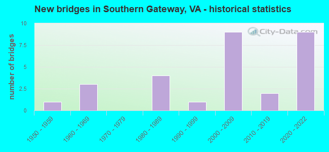
- New bridges - historical statistics
- 11950-1959
- 31960-1969
- 41980-1989
- 11990-1999
- 92000-2009
- 22010-2019
- 92020-2022

- Reconstructed bridges - Historical Statistics
- 11980-1989
- 11990-1999


- Bridge Condition - Deck
- 40.0%Very good
- 40.0%Good
- 20.0%Satisfactory

- Bridge Condition - Superstructure
- 50.0%Very good
- 30.0%Good
- 10.0%Satisfactory
- 10.0%Fair

- Bridge Condition - Substructure
- 40.0%Very good
- 20.0%Good
- 20.0%Satisfactory
- 20.0%Fair

- Bridge Condition - Channel
- 11.1%Very good
- 22.2%Good
- 33.3%Satisfactory
- 33.3%Fair

- Bridge Condition - Culverts
- 16.7%Very good
- 16.7%Good
- 50.0%Satisfactory
- 16.7%Fair
Find on map >> Show street view
Structure Number: 942, Location: 0.52 ECL COV - 7.22 RT 60 (Lat: 37.775053, Lng: -79.967600), Route carried "on" structure: Interstate 64, Year Built: 1964, Year Reconstructed: 2001, Status: Open, Structure Length: 5.30m (17.39ft), Average Daily Traffic: 4,304 (year 2020), Truck Traffic: 24%, Average Future Daily Traffic: 6,026 (year 2040), Design Load: HS 20+Mod, Features Intersected: CONN TO RTES 60 & 220
Minimum Vertical Clearance: 30+ m (98+ ft), Kilometerpoint: 26.680, Lanes on structure: 4, Lanes under structure: 4, Base Highway Network: Yes, Owner: State Highway Agency, Approaching Roadway Width: 11.3m (37.1ft), Material/Design: Steel, Design/Construction: Stringer/Multi-beam, Number Of Spans In Main Unit: 3, Length of Maximum Span: 24.2m (79.4ft), Curb-To-Curb Width: 22.3m (73.2ft), Out-to-Out Width: 23.3m (76.4ft)
Condition: Deck: Good, Superstructure: Good, Substructure: Good, Operating Rating: 59.0 metric tons, Method Used To Determine Operating Rating: Load and Resistance Factor (LRFR), Inventory Rating: 45.4 metric tons, Method Used To Determine Inventory Rating: Load and Resistance Factor (LRFR), Structural Evaluation: Better than present minimum criteria, Deck Geometry: Superior to present desirable criteria, Underclear: High priority of corrective action, Approach Roadway Alignment: Equal to present desirable criteria, Designated Inspection Frequency: Every 24 months, Inspection Date: October 2020, Deck Structure Type: Concrete Cast-file-Place, Wearing Surface/Protective System: Wearing Surface: Latex Concrete, Deck Protection: Epoxy Coated Reinforcing
Find on map >> Show street view
Structure Number: 18095, Location: 0.6M RTE17-6.4M RTE630 (Lat: 38.346164, Lng: -77.485031), Route carried "on" structure: Interstate 95, Year Built: 1964, Status: Open, Structure Length: 0.85m (2.79ft), Average Daily Traffic: 123,295 (year 2020), Truck Traffic: 10%, Average Future Daily Traffic: 125,061 (year 2040), Design Load: HS 20, Features Intersected: STREAM
Minimum Vertical Clearance: 30+ m (98+ ft), Kilometerpoint: 215.992, Lanes on structure: 4, Base Highway Network: Yes, Owner: State Highway Agency, Approaching Roadway Width: 26.8m (87.9ft), Skew: 12 degrees, Material/Design: Concrete, Design/Construction: Culvert, Number Of Spans In Main Unit: 3, Length of Maximum Span: 2.4m (7.9ft)
Condition: Channel: Fair, Culverts: Fair, Operating Rating: 89.8 metric tons, Method Used To Determine Operating Rating: Field evaluation and documented engineering judgment, Inventory Rating: 89.8 metric tons, Method Used To Determine Inventory Rating: Field evaluation and documented engineering judgment, Structural Evaluation: Somewhat better than minimum adequacy, Waterway Adequacy: Superior to present desirable criteria, Approach Roadway Alignment: Equal to present desirable criteria, Designated Inspection Frequency: Every 12 months, Inspection Date: October 2021
Find on map >> Show street view
Structure Number: 18111, Location: 1.2M SPOTSY.-6.9M RTE630 (Lat: 38.340014, Lng: -77.491739), Route carried "on" structure: Interstate 95, Year Built: 1985, Status: Open, Structure Length: 4.95m (16.24ft), Average Daily Traffic: 19,813 (year 2020), Truck Traffic: 10%, Average Future Daily Traffic: 21,794 (year 2040), Design Load: HS 20+Mod, Features Intersected: RTE. 17
Minimum Vertical Clearance: 30+ m (98+ ft), Kilometerpoint: 214.980, Lanes on structure: 2, Lanes under structure: 8, Base Highway Network: Yes, Owner: State Highway Agency, Approaching Roadway Width: 7.3m (24.0ft), Material/Design: Steel continuous, Design/Construction: Stringer/Multi-beam, Number Of Spans In Main Unit: 2, Length of Maximum Span: 25.0m (82.0ft), Curb-To-Curb Width: 12.2m (40.0ft), Out-to-Out Width: 16.5m (54.1ft)
Condition: Deck: Satisfactory, Superstructure: Fair, Substructure: Fair, Operating Rating: 61.3 metric tons, Method Used To Determine Operating Rating: Load and Resistance Factor (LRFR), Inventory Rating: 47.4 metric tons, Method Used To Determine Inventory Rating: Load and Resistance Factor (LRFR), Structural Evaluation: Somewhat better than minimum adequacy, Deck Geometry: Better than present minimum criteria, Underclear: Meets minimum limits, Approach Roadway Alignment: Equal to present desirable criteria, Length Of Structure Improvement: 5.03m (16.50ft), Designated Inspection Frequency: Every 12 months, Inspection Date: October 2021, Bridge Improvement Cost: $90,000, Roadway Improvement Cost: $40,000, Total Project Cost: $130,000, Deck Structure Type: Concrete Precast Panels, Wearing Surface/Protective System: Wearing Surface: Monolithic Concrete, Deck Protection: Epoxy Coated Reinforcing
Find on map >> Show street view
Structure Number: 18142, Location: 0.4M DE-0.4M RTE. 8900 (Lat: 38.383850, Lng: -77.468383), Route carried "on" structure: County highway 627, Year Built: 1955, Status: Open, Structure Length: 2.65m (8.69ft), Average Daily Traffic: 69 (year 2020), Average Future Daily Traffic: 76 (year 2040), Design Load: HS 15, Features Intersected: POTOMAC CREEK, Facility Carried by Structure: MOUNTAIN VIEW RD.
Minimum Vertical Clearance: 30+ m (98+ ft), Kilometerpoint: 15.681, Lanes on structure: 2, Owner: State Highway Agency, Approaching Roadway Width: 6.1m (20.0ft), Skew: 3 degrees, Material/Design: Concrete, Design/Construction: Tee Beam, Number Of Spans In Main Unit: 2, Length of Maximum Span: 13.4m (44.0ft), Curb-To-Curb Width: 7.3m (24.0ft), Out-to-Out Width: 8.2m (26.9ft)
Condition: Deck: Satisfactory, Superstructure: Satisfactory, Substructure: Satisfactory, Channel: Satisfactory, Operating Rating: 47.7 metric tons, Method Used To Determine Operating Rating: Load and Resistance Factor (LRFR), Inventory Rating: 36.8 metric tons, Method Used To Determine Inventory Rating: Load and Resistance Factor (LRFR), Structural Evaluation: Equal to present minimum criteria, Deck Geometry: Equal to present minimum criteria, Waterway Adequacy: Better than present minimum criteria, Approach Roadway Alignment: Equal to present desirable criteria, Length Of Structure Improvement: 3.05m (10.01ft), Designated Inspection Frequency: Every 24 months, Inspection Date: November 2020, Bridge Improvement Cost: $250,000, Roadway Improvement Cost: $50,000, Total Project Cost: $300,000, Deck Structure Type: Concrete Cast-file-Place, Wearing Surface/Protective System: Wearing Surface: Latex Concrete
Find on map >> Show street view
Structure Number: 1816, Location: 1.2M RTE650-1.3M RTE627 (Lat: 38.412653, Lng: -77.495219), Route carried "on" structure: County highway 651, Year Built: 1962, Year Reconstructed: 1993, Status: Open, Structure Length: 6.46m (21.19ft), Average Daily Traffic: 2,869 (year 2020), Average Future Daily Traffic: 3,156 (year 2040), Design Load: HS 15, Features Intersected: POTOMAC RUN, Facility Carried by Structure: KELLOGG MILL RD.
Minimum Vertical Clearance: 30+ m (98+ ft), Kilometerpoint: 4.183, Lanes on structure: 2, Owner: State Highway Agency, Approaching Roadway Width: 5.5m (18.0ft), Material/Design: Steel, Design/Construction: Stringer/Multi-beam, Number Of Spans In Main Unit: 4, Length of Maximum Span: 16.2m (53.1ft), Curb-To-Curb Width: 7.9m (25.9ft), Out-to-Out Width: 8.9m (29.2ft)
Condition: Deck: Good, Superstructure: Good, Substructure: Satisfactory, Channel: Very good, Operating Rating: 52.2 metric tons, Method Used To Determine Operating Rating: Load and Resistance Factor (LRFR), Inventory Rating: 40.3 metric tons, Method Used To Determine Inventory Rating: Load and Resistance Factor (LRFR), Structural Evaluation: Equal to present minimum criteria, Deck Geometry: High priority of corrective action, Waterway Adequacy: Better than present minimum criteria, Approach Roadway Alignment: Equal to present desirable criteria, Length Of Structure Improvement: 6.46m (21.19ft), Designated Inspection Frequency: Every 24 months, Underwater Inspection Frequency: Every 60 months, Inspection Date: November 2021, Underwater Inspection Date: October 2018, Bridge Improvement Cost: $44,000, Roadway Improvement Cost: $10,000, Total Project Cost: $54,000, Deck Structure Type: Concrete Cast-file-Place, Wearing Surface/Protective System: Wearing Surface: Monolithic Concrete
Find on map >> Show street view
Structure Number: 23924, Location: 0.1M RTE670-0.4M DEAD END (Lat: 38.341036, Lng: -77.498831), Route carried "on" structure: County highway 1445, Year Built: 1988, Status: Open, Structure Length: 0.82m (2.69ft), Average Daily Traffic: 1,442 (year 2018), Average Future Daily Traffic: 1,601 (year 2040), Design Load: HS 20, Features Intersected: MATT'S CREEK, Facility Carried by Structure: RIVERSIDE PARKWAY
Minimum Vertical Clearance: 30+ m (98+ ft), Kilometerpoint: 1.255, Lanes on structure: 4, Owner: State Highway Agency, Approaching Roadway Width: 15.2m (49.9ft), Skew: 3 degrees, Material/Design: Steel, Design/Construction: Culvert, Number Of Spans In Main Unit: 2, Length of Maximum Span: 3.4m (11.2ft)
Condition: Channel: Fair, Culverts: Satisfactory, Operating Rating: 44.5 metric tons, Method Used To Determine Operating Rating: Field evaluation and documented engineering judgment, Inventory Rating: 32.7 metric tons, Method Used To Determine Inventory Rating: Field evaluation and documented engineering judgment, Structural Evaluation: Equal to present minimum criteria, Waterway Adequacy: Equal to present desirable criteria, Approach Roadway Alignment: Equal to present desirable criteria, Designated Inspection Frequency: Every 24 months, Inspection Date: November 2021
Find on map >> Show street view
Structure Number: 26783, Location: 0.0M RTE627-1.2M RTE I-95 (Lat: 38.387378, Lng: -77.472731), Route carried "on" structure: County highway 8900, Year Built: 2005, Status: Open, Structure Length: 2.99m (9.81ft), Average Daily Traffic: 5,744 (year 2020), Truck Traffic: 2%, Average Future Daily Traffic: 8,042 (year 2040), Design Load: HS 20+Mod, Features Intersected: POTOMAC CREEK, Facility Carried by Structure: Centreport Pkwy
Minimum Vertical Clearance: 30+ m (98+ ft), Kilometerpoint: 3.749, Lanes on structure: 2, Owner: State Highway Agency, Approaching Roadway Width: 9.4m (30.8ft), Material/Design: Steel, Design/Construction: Stringer/Multi-beam, Number Of Spans In Main Unit: 1, Length of Maximum Span: 28.0m (91.9ft), Curb-To-Curb Width: 15.8m (51.8ft), Out-to-Out Width: 16.5m (54.1ft)
Condition: Deck: Good, Superstructure: Very good, Substructure: Very good, Channel: Good, Operating Rating: 63.6 metric tons, Method Used To Determine Operating Rating: Load and Resistance Factor (LRFR), Inventory Rating: 49.1 metric tons, Method Used To Determine Inventory Rating: Load and Resistance Factor (LRFR), Structural Evaluation: Equal to present desirable criteria, Deck Geometry: Superior to present desirable criteria, Waterway Adequacy: Superior to present desirable criteria, Approach Roadway Alignment: Equal to present desirable criteria, Designated Inspection Frequency: Every 24 months, Inspection Date: November 2020, Deck Structure Type: Concrete Cast-file-Place
Find on map >> Show street view
Structure Number: 2812, Location: 0.7M RTE.17-0.7M RTE.652 (Lat: 38.360067, Lng: -77.497975), Route carried "on" structure: County highway 1706, Year Built: 1998, Status: Open, Structure Length: 1.40m (4.59ft), Average Daily Traffic: 9,620 (year 2020), Average Future Daily Traffic: 10,582 (year 2040), Design Load: HS 20, Features Intersected: FALLS RUN CREEK, Facility Carried by Structure: PLANTATION DR.
Minimum Vertical Clearance: 30+ m (98+ ft), Kilometerpoint: 1.223, Lanes on structure: 2, Owner: State Highway Agency, Approaching Roadway Width: 10.7m (35.1ft), Material/Design: Steel, Design/Construction: Culvert, Number Of Spans In Main Unit: 3, Length of Maximum Span: 4.0m (13.1ft)
Condition: Channel: Satisfactory, Culverts: Very good, Operating Rating: 44.5 metric tons, Method Used To Determine Operating Rating: Field evaluation and documented engineering judgment, Inventory Rating: 32.7 metric tons, Method Used To Determine Inventory Rating: Field evaluation and documented engineering judgment, Structural Evaluation: Equal to present desirable criteria, Waterway Adequacy: Equal to present desirable criteria, Approach Roadway Alignment: Equal to present desirable criteria, Designated Inspection Frequency: Every 24 months, Inspection Date: November 2020
Find on map >> Show street view
Structure Number: 28123, Location: .8M RTE. 17-.2M Rte. 1822 (Lat: 38.364406, Lng: -77.541906), Route carried "on" structure: County highway 1800, Year Built: 2003, Status: Open, Structure Length: 0.91m (2.99ft), Average Daily Traffic: 8,878 (year 2018), Average Future Daily Traffic: 12,784 (year 2040), Design Load: HS 20, Features Intersected: PEN RUN CREEK, Facility Carried by Structure: VILLAGE PKWY
Minimum Vertical Clearance: 30+ m (98+ ft), Kilometerpoint: 0.322, Lanes on structure: 2, Owner: State Highway Agency, Approaching Roadway Width: 20.1m (65.9ft), Material/Design: Concrete, Design/Construction: Arch - Deck, Number Of Spans In Main Unit: 1, Length of Maximum Span: 9.1m (29.9ft), Curb or Sidewalk Widths: Left: 0.0m, Right: 1.2m (3.9ft), Curb-To-Curb Width: 21.5m (70.5ft), Out-to-Out Width: 57.6m (189.0ft)
Condition: Deck: Very good, Superstructure: Very good, Substructure: Good, Channel: Good, Operating Rating: 86.4 metric tons, Method Used To Determine Operating Rating: Load and Resistance Factor (LRFR), Inventory Rating: 69.7 metric tons, Method Used To Determine Inventory Rating: Load and Resistance Factor (LRFR), Structural Evaluation: Better than present minimum criteria, Deck Geometry: Superior to present desirable criteria, Waterway Adequacy: Equal to present desirable criteria, Approach Roadway Alignment: Equal to present desirable criteria, Designated Inspection Frequency: Every 24 months, Inspection Date: November 2020
Find on map >> Show street view
Structure Number: 28533, Location: 0.1M RT 700-0.15M RT 654 (Lat: 38.359600, Lng: -77.518619), Route carried "on" structure: US 17, Year Built: 2006, Status: Open, Structure Length: 1.40m (4.59ft), Average Daily Traffic: 59,093 (year 2020), Truck Traffic: 17%, Average Future Daily Traffic: 82,730 (year 2040), Design Load: HS 20+Mod, Features Intersected: VIRGINIA PKWY, Facility Carried by Structure: WARRENTON ROAD
Minimum Vertical Clearance: 30+ m (98+ ft), Kilometerpoint: 295.654, Lanes on structure: 6, Lanes under structure: 2, Base Highway Network: Yes, Owner: State Highway Agency, Approaching Roadway Width: 10.7m (35.1ft), Skew: 21 degrees, Material/Design: Concrete, Design/Construction: Culvert, Number Of Spans In Main Unit: 1, Length of Maximum Span: 14.0m (45.9ft), Curb or Sidewalk Widths: Left: 1.7m (5.6ft), Right: 1.7m (5.6ft), Curb-To-Curb Width: 16.2m (53.1ft), Out-to-Out Width: 49.7m (163.1ft)
Condition: Culverts: Satisfactory, Operating Rating: 99.8 metric tons, Method Used To Determine Operating Rating: Load and Resistance Factor (LRFR), Inventory Rating: 77.1 metric tons, Method Used To Determine Inventory Rating: Load and Resistance Factor (LRFR), Structural Evaluation: Equal to present minimum criteria, Deck Geometry: High priority of replacement, Underclear: High priority of corrective action, Approach Roadway Alignment: Equal to present desirable criteria, Length Of Structure Improvement: 1.07m (3.51ft), Designated Inspection Frequency: Every 12 months, Inspection Date: October 2021, Bridge Improvement Cost: $2,000, Roadway Improvement Cost: $1,000, Total Project Cost: $3,000, Deck Structure Type: Concrete Cast-file-Place, Wearing Surface/Protective System: Deck Protection: Epoxy Coated Reinforcing
Find on map >> Show street view
Structure Number: 28535, Location: .1 M RTE.17-.2 M RTE.699 (Lat: 38.359586, Lng: -77.516972), Route carried "on" structure: County highway 700, Year Built: 2006, Status: Open, Structure Length: 1.40m (4.59ft), Average Daily Traffic: 2,731 (year 2018), Average Future Daily Traffic: 3,012 (year 2040), Design Load: HS 20+Mod, Features Intersected: VIRGINIA PKWY, Facility Carried by Structure: INTERNATIONAL PKWY
Minimum Vertical Clearance: 30+ m (98+ ft), Kilometerpoint: 2.124, Lanes on structure: 2, Lanes under structure: 2, Owner: State Highway Agency, Approaching Roadway Width: 9.1m (29.9ft), Skew: 1 degrees, Material/Design: Concrete, Design/Construction: Culvert, Number Of Spans In Main Unit: 1, Length of Maximum Span: 14.0m (45.9ft), Curb or Sidewalk Widths: Left: 1.6m (5.2ft), Right: 1.6m (5.2ft), Curb-To-Curb Width: 10.5m (34.4ft), Out-to-Out Width: 15.3m (50.2ft)
Condition: Culverts: Good, Operating Rating: 99.8 metric tons, Method Used To Determine Operating Rating: Load and Resistance Factor (LRFR), Inventory Rating: 78.0 metric tons, Method Used To Determine Inventory Rating: Load and Resistance Factor (LRFR), Structural Evaluation: Better than present minimum criteria, Deck Geometry: Somewhat better than minimum adequacy, Underclear: High priority of corrective action, Approach Roadway Alignment: Equal to present desirable criteria, Designated Inspection Frequency: Every 24 months, Inspection Date: November 2020, Deck Structure Type: Concrete Cast-file-Place, Wearing Surface/Protective System: Deck Protection: Epoxy Coated Reinforcing
Find on map >> Show street view
Structure Number: 29025, Location: 1.7M RTE 17-1.5M END SM (Lat: 38.337597, Lng: -77.517481), Route carried "on" structure: County highway 1968, Year Built: 2005, Status: Open, Structure Length: 1.16m (3.81ft), Average Daily Traffic: 200 (year 2007), Average Future Daily Traffic: 250 (year 2030), Design Load: HS 20+Mod, Features Intersected: SANFORD RD., Facility Carried by Structure: CELEBRATE VIRGINIA
Minimum Vertical Clearance: 5.51m (18.08ft), Kilometerpoint: 0.000, Lanes on structure: 4, Lanes under structure: 2, Owner: State Highway Agency, Approaching Roadway Width: 7.3m (24.0ft), Skew: 20 degrees, Material/Design: Concrete, Design/Construction: Culvert, Number Of Spans In Main Unit: 1, Length of Maximum Span: 11.6m (38.1ft), Curb or Sidewalk Widths: Left: 4.3m (14.1ft), Right: 3.7m (12.1ft), Curb-To-Curb Width: 22.1m (72.5ft), Out-to-Out Width: 39.6m (129.9ft)
Condition: Culverts: Satisfactory, Operating Rating: 99.8 metric tons, Method Used To Determine Operating Rating: Load and Resistance Factor (LRFR), Inventory Rating: 96.2 metric tons, Method Used To Determine Inventory Rating: Load and Resistance Factor (LRFR), Structural Evaluation: Equal to present minimum criteria, Deck Geometry: Superior to present desirable criteria, Underclear: Superior to present desirable criteria, Approach Roadway Alignment: Equal to present desirable criteria, Designated Inspection Frequency: Every 24 months, Inspection Date: November 2020
Find on map >> Show street view
Structure Number: 30871, Location: Spotsy.-Stafford Co. Line (Lat: 38.328167, Lng: -77.501139), Route carried "on" structure: Interstate 95, Year Built: 2021, Status: Open, Structure Length: 36.60m (120.08ft), Average Daily Traffic: 65,201 (year 2020), Truck Traffic: 14%, Average Future Daily Traffic: 91,281 (year 2040), Design Load: HL 93, Features Intersected: RAPPAHANNOCK RIVER
Minimum Vertical Clearance: 3.05m (10.01ft), Kilometerpoint: 0.000, Lanes on structure: 3, Owner: State Highway Agency, Approaching Roadway Width: 17.7m (58.1ft), Material/Design: Steel continuous, Design/Construction: Stringer/Multi-beam, Number Of Spans In Main Unit: 5, Length of Maximum Span: 82.3m (270.0ft), Curb-To-Curb Width: 18.3m (60.0ft), Out-to-Out Width: 19.2m (63.0ft)
Condition: Deck: Very good, Superstructure: Very good, Substructure: Very good, Channel: Satisfactory, Operating Rating: 70.1 metric tons, Method Used To Determine Operating Rating: Load and Resistance Factor (LRFR), Inventory Rating: 54.1 metric tons, Method Used To Determine Inventory Rating: Load and Resistance Factor (LRFR), Structural Evaluation: Equal to present desirable criteria, Deck Geometry: High priority of corrective action, Waterway Adequacy: Equal to present minimum criteria, Approach Roadway Alignment: Equal to present desirable criteria, Designated Inspection Frequency: Every 24 months, Inspection Date: October 2021, Deck Structure Type: Concrete Cast-file-Place, Wearing Surface/Protective System: Deck Protection: Other Coated Reinforcing
Find on map >> Show street view
Structure Number: 30872, Location: 1.2M Spotsy-6.9M Rte.630 (Lat: 38.340861, Lng: -77.492222), Route carried "on" structure: Interstate 95, Year Built: 2021, Status: Open, Structure Length: 4.42m (14.50ft), Average Daily Traffic: 85,800 (year 2020), Truck Traffic: 13%, Average Future Daily Traffic: 90,000 (year 2030), Design Load: HL 93, Features Intersected: Route 17
Minimum Vertical Clearance: 30+ m (98+ ft), Kilometerpoint: 0.000, Lanes on structure: 4, Lanes under structure: 6, Owner: State Highway Agency, Approaching Roadway Width: 12.8m (42.0ft), Material/Design: Prestressed concrete, Design/Construction: Girder and Floorbeam System, Number Of Spans In Main Unit: 2, Length of Maximum Span: 22.7m (74.5ft), Curb-To-Curb Width: 12.8m (42.0ft), Out-to-Out Width: 27.2m (89.2ft)
Condition: Deck: Very good, Superstructure: Very good, Substructure: Very good, Operating Rating: 91.8 metric tons, Method Used To Determine Operating Rating: Load and Resistance Factor (LRFR), Inventory Rating: 50.1 metric tons, Method Used To Determine Inventory Rating: Load and Resistance Factor (LRFR), Structural Evaluation: Equal to present desirable criteria, Deck Geometry: High priority of replacement, Underclear: High priority of corrective action, Approach Roadway Alignment: Equal to present desirable criteria, Designated Inspection Frequency: Every 24 months, Inspection Date: October 2021, Deck Structure Type: Concrete Cast-file-Place, Wearing Surface/Protective System: Deck Protection: Other
Find on map >> Show street view
Structure Number: 3089, Location: 1.2M SPOTSY.-6.9M RTE630 (Lat: 38.340139, Lng: -77.491861), Route carried "on" structure: Interstate 95, Year Built: 2020, Status: Open, Structure Length: 4.42m (14.50ft), Average Daily Traffic: 65,720 (year 2020), Truck Traffic: 12%, Average Future Daily Traffic: 92,008 (year 2040), Design Load: HL 93, Features Intersected: RTE. 17
Minimum Vertical Clearance: 3.05m (10.01ft), Kilometerpoint: 214.988, Lanes on structure: 3, Lanes under structure: 6, Base Highway Network: Yes, Owner: State Highway Agency, Approaching Roadway Width: 17.7m (58.1ft), Material/Design: Concrete, Design/Construction: Stringer/Multi-beam, Number Of Spans In Main Unit: 2, Length of Maximum Span: 22.7m (74.5ft), Curb-To-Curb Width: 18.3m (60.0ft), Out-to-Out Width: 19.3m (63.3ft)
Condition: Deck: Very good, Superstructure: Very good, Substructure: Very good, Operating Rating: 91.7 metric tons, Method Used To Determine Operating Rating: Load and Resistance Factor (LRFR), Inventory Rating: 50.1 metric tons, Method Used To Determine Inventory Rating: Load and Resistance Factor (LRFR), Structural Evaluation: Equal to present desirable criteria, Deck Geometry: High priority of corrective action, Underclear: High priority of corrective action, Approach Roadway Alignment: Equal to present desirable criteria, Length Of Structure Improvement: 5.85m (19.19ft), Designated Inspection Frequency: Every 24 months, Inspection Date: October 2021, Bridge Improvement Cost: $100,000, Roadway Improvement Cost: $50,000, Total Project Cost: $150,000, Deck Structure Type: Concrete Cast-file-Place, Wearing Surface/Protective System: Wearing Surface: Latex Concrete, Deck Protection: Other Coated Reinforcing
Find on map >> Show street view
Structure Number: 31643, Location: 1.1 to Rt 1969-1.4 to ESM (Lat: 38.340944, Lng: -77.516222), Route carried "on" structure: County highway 1968, Year Built: 2006, Status: Open, Structure Length: 1.10m (3.61ft), Average Daily Traffic: 1,100 (year 2012), Average Future Daily Traffic: 4,400 (year 2029), Design Load: HS 20+Mod, Features Intersected: England Run, Facility Carried by Structure: Celebrate VA Pkwy
Minimum Vertical Clearance: 30+ m (98+ ft), Kilometerpoint: 0.000, Lanes on structure: 4, Owner: State Highway Agency, Approaching Roadway Width: 8.8m (28.9ft), Material/Design: Concrete, Design/Construction: Frame, Number Of Spans In Main Unit: 1, Length of Maximum Span: 11.0m (36.1ft), Curb-To-Curb Width: 7.6m (24.9ft), Out-to-Out Width: 53.6m (175.9ft)
Condition: Deck: Good, Superstructure: Good, Substructure: Fair, Channel: Fair, Operating Rating: 44.5 metric tons, Method Used To Determine Operating Rating: Field evaluation and documented engineering judgment, Inventory Rating: 32.7 metric tons, Method Used To Determine Inventory Rating: Field evaluation and documented engineering judgment, Structural Evaluation: Somewhat better than minimum adequacy, Deck Geometry: High priority of replacement, Waterway Adequacy: Equal to present desirable criteria, Approach Roadway Alignment: Equal to present desirable criteria, Designated Inspection Frequency: Every 24 months, Inspection Date: Febuary 2022
Find on map >> Show street view
Structure Number: 18111, Location: 1.2M SPOTSY.-6.9M RTE630 (Lat: 38.340014, Lng: -77.491739), Route carried "under" structure: US 17, Year Built: 1985, Structure Length: 0. m, Average Daily Traffic: 38,678 (year 2019), Truck Traffic: 3%, Features Intersected: RTE. 17, Facility Carried by Structure: C.D. NBL RTE. I-95
Minimum Vertical Clearance: 4.65m (15.26ft), Kilometerpoint: 0.048, Lanes on structure: 2, Lanes under structure: 4, Material/Design: Steel continuous, Design/Construction: Stringer/Multi-beam, Length of Maximum Span: 25.0m (82.0ft)
Find on map >> Show street view
Structure Number: 18111, Location: 1.2M SPOTSY.-6.9M RTE630 (Lat: 38.340014, Lng: -77.491739), Route carried "under" structure: US 17, Year Built: 1985, Structure Length: 0. m, Average Daily Traffic: 38,678 (year 2019), Truck Traffic: 5%, Features Intersected: RTE. 17, Facility Carried by Structure: C.D. NBL RTE. I-95
Minimum Vertical Clearance: 4.72m (15.49ft), Kilometerpoint: 0.048, Lanes on structure: 2, Lanes under structure: 4, Material/Design: Steel continuous, Design/Construction: Stringer/Multi-beam, Length of Maximum Span: 25.0m (82.0ft)
Find on map >> Show street view
Structure Number: 26195, Location: 1.9M Rte 1-1.0M Rte753 (Lat: 38.351556, Lng: -77.478389), Route carried "under" structure: Interstate 95, Year Built: 2021, Structure Length: 0. m, Average Daily Traffic: 59,727 (year 2020), Truck Traffic: 15%, Features Intersected: I-95, Facility Carried by Structure: TRUSLOW ROAD
Minimum Vertical Clearance: 5.12m (16.80ft), Kilometerpoint: 0.000, Lanes on structure: 2, Lanes under structure: 3, Material/Design: Prestressed concrete continuous, Design/Construction: Stringer/Multi-beam, Length of Maximum Span: 39.9m (130.9ft)
Find on map >> Show street view
Structure Number: 26195, Location: 1.9M Rte 1-1.0M Rte753 (Lat: 38.351556, Lng: -77.478389), Route carried "under" structure: Interstate 95, Year Built: 2021, Structure Length: 0. m, Average Daily Traffic: 63,568 (year 2020), Truck Traffic: 15%, Features Intersected: I-95, Facility Carried by Structure: TRUSLOW ROAD
Minimum Vertical Clearance: 5.06m (16.60ft), Kilometerpoint: 0.000, Lanes on structure: 2, Lanes under structure: 3, Material/Design: Prestressed concrete continuous, Design/Construction: Stringer/Multi-beam, Length of Maximum Span: 39.9m (130.9ft)
Find on map >> Show street view
Structure Number: 28533, Location: 0.1M RT 700-0.15M RT 654 (Lat: 38.359600, Lng: -77.518619), Route carried "under" structure: County highway , Year Built: 2006, Structure Length: 0. m, Average Daily Traffic: 100 (year 2011), Features Intersected: VIRGINIA PKWY, Facility Carried by Structure: WARRENTON ROAD
Minimum Vertical Clearance: 5.31m (17.42ft), Kilometerpoint: 0.000, Lanes on structure: 6, Lanes under structure: 2, Material/Design: Concrete, Design/Construction: Culvert, Length of Maximum Span: 14.0m (45.9ft)
Find on map >> Show street view
Structure Number: 28535, Location: .1 M RTE.17-.2 M RTE.699 (Lat: 38.359586, Lng: -77.516972), Route carried "under" structure: County highway , Year Built: 2006, Structure Length: 0. m, Average Daily Traffic: 1,000 (year 2010), Features Intersected: VIRGINIA PKWY, Facility Carried by Structure: INTERNATIONAL PKWY
Minimum Vertical Clearance: 5.31m (17.42ft), Kilometerpoint: 0.000, Lanes on structure: 2, Lanes under structure: 2, Material/Design: Concrete, Design/Construction: Culvert, Length of Maximum Span: 14.0m (45.9ft)
Find on map >> Show street view
Structure Number: 29025, Location: 1.7M RTE 17-1.5M END SM (Lat: 38.337597, Lng: -77.517481), Route carried "under" structure: County highway 670, Year Built: 2005, Structure Length: 0. m, Average Daily Traffic: 2,163 (year 2008), Features Intersected: SANFORD RD., Facility Carried by Structure: CELEBRATE VIRGINIA
Minimum Vertical Clearance: 5.51m (18.08ft), Kilometerpoint: 1.287, Lanes on structure: 4, Lanes under structure: 2, Toll: On toll road, Material/Design: Concrete, Design/Construction: Culvert, Length of Maximum Span: 11.6m (38.1ft)
Find on map >> Show street view
Structure Number: 30872, Location: 1.2M Spotsy-6.9M Rte.630 (Lat: 38.340861, Lng: -77.492222), Route carried "under" structure: State highway 17, Year Built: 2021, Structure Length: 0. m, Average Daily Traffic: 39,898 (year 2008), Truck Traffic: 16%, Features Intersected: Route 17, Facility Carried by Structure: I-95 SB CD Lanes
Minimum Vertical Clearance: 5.24m (17.19ft), Kilometerpoint: 0.000, Lanes on structure: 4, Lanes under structure: 3, Material/Design: Prestressed concrete, Design/Construction: Girder and Floorbeam System, Length of Maximum Span: 22.7m (74.5ft)
Find on map >> Show street view
Structure Number: 30872, Location: 1.2M Spotsy-6.9M Rte.630 (Lat: 38.340861, Lng: -77.492222), Route carried "under" structure: State highway 17, Year Built: 2021, Structure Length: 0. m, Average Daily Traffic: 39,898 (year 2008), Truck Traffic: 16%, Features Intersected: Route 17, Facility Carried by Structure: I-95 SB CD Lanes
Minimum Vertical Clearance: 5.33m (17.49ft), Kilometerpoint: 0.000, Lanes on structure: 4, Lanes under structure: 3, Material/Design: Prestressed concrete, Design/Construction: Girder and Floorbeam System, Length of Maximum Span: 22.7m (74.5ft)
Find on map >> Show street view
Structure Number: 30873, Location: 1.2M Spotsy-6.9M Rte630 (Lat: 38.340456, Lng: -77.492478), Route carried "under" structure: US 17, Year Built: 2019, Structure Length: 0. m, Average Daily Traffic: 39,898 (year 2008), Truck Traffic: 16%, Features Intersected: ROUTE 17, Facility Carried by Structure: ROUTE I-95
Minimum Vertical Clearance: 5.33m (17.49ft), Kilometerpoint: 0.000, Lanes on structure: 3, Lanes under structure: 3, Material/Design: Prestressed concrete, Design/Construction: Girder and Floorbeam System, Length of Maximum Span: 22.7m (74.5ft)
Find on map >> Show street view
Structure Number: 30873, Location: 1.2M Spotsy-6.9M Rte630 (Lat: 38.340456, Lng: -77.492478), Route carried "under" structure: US 17, Year Built: 2019, Structure Length: 0. m, Average Daily Traffic: 39,898 (year 2008), Truck Traffic: 16%, Features Intersected: ROUTE 17, Facility Carried by Structure: ROUTE I-95
Minimum Vertical Clearance: 5.24m (17.19ft), Kilometerpoint: 0.000, Lanes on structure: 3, Lanes under structure: 3, Material/Design: Prestressed concrete, Design/Construction: Girder and Floorbeam System, Length of Maximum Span: 22.7m (74.5ft)
Find on map >> Show street view
Structure Number: 3089, Location: 1.2M SPOTSY.-6.9M RTE630 (Lat: 38.340139, Lng: -77.491861), Route carried "under" structure: State highway 17, Year Built: 2020, Structure Length: 0. m, Average Daily Traffic: 38,678 (year 2019), Truck Traffic: 3%, Features Intersected: RTE. 17, Facility Carried by Structure: NBL RTE. I-95
Minimum Vertical Clearance: 5.27m (17.29ft), Kilometerpoint: 0.000, Lanes on structure: 3, Lanes under structure: 3, Material/Design: Concrete, Design/Construction: Stringer/Multi-beam, Length of Maximum Span: 22.7m (74.5ft)
Find on map >> Show street view
Structure Number: 3089, Location: 1.2M SPOTSY.-6.9M RTE630 (Lat: 38.340139, Lng: -77.491861), Route carried "under" structure: State highway 17, Year Built: 2020, Structure Length: 0. m, Average Daily Traffic: 20,737 (year 2019), Truck Traffic: 3%, Features Intersected: RTE. 17, Facility Carried by Structure: NBL RTE. I-95
Minimum Vertical Clearance: 5.33m (17.49ft), Kilometerpoint: 0.000, Lanes on structure: 3, Lanes under structure: 3, Material/Design: Concrete, Design/Construction: Stringer/Multi-beam, Length of Maximum Span: 22.7m (74.5ft)