Bridge Statistics for Spencer, New York (NY)
Condition, Traffic, Stress, Structural Evaluation, Project Costs
- National Bridge Inventory (NBI) Statistics
- 23Number of bridges
- 112ft / 33.6mTotal length
- $15,814,000Total costs
- 24,765Total average daily traffic
- 1,766Total average daily truck traffic
- National Bridge Inventory (NBI) Registered Bridges for Spencer
- No street view available for this location
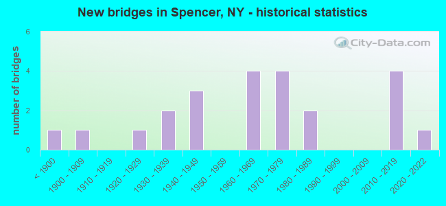
- New bridges - historical statistics
- 1Before 1900
- 11900-1909
- 11920-1929
- 21930-1939
- 31940-1949
- 41960-1969
- 41970-1979
- 21980-1989
- 42010-2019
- 12020-2022

- Reconstructed bridges - Historical Statistics
- 11980-1989
- 11990-1999
- 32000-2009
- 22010-2019


- Bridge Condition - Deck
- 23.5%Excellent
- 11.8%Very good
- 23.5%Good
- 23.5%Satisfactory
- 17.6%Fair

- Bridge Condition - Superstructure
- 35.3%Excellent
- 5.9%Very good
- 29.4%Good
- 17.6%Satisfactory
- 11.8%Fair

- Bridge Condition - Substructure
- 17.6%Excellent
- 17.6%Very good
- 17.6%Good
- 17.6%Satisfactory
- 29.4%Fair

- Bridge Condition - Channel
- 5.0%Excellent
- 5.0%Very good
- 20.0%Good
- 35.0%Satisfactory
- 30.0%Fair
- 5.0%Poor

- Bridge Condition - Culverts
- 25.0%Excellent
- 25.0%Good
- 25.0%Satisfactory
- 25.0%Poor
Find on map >> Show street view
Structure Number: 102321, Location: 0.2 MI E OF SPENCER (Lat: 42.207836, Lng: -76.503344), Route carried "on" structure: State highway 34, Year Built: 1941, Year Reconstructed: 2014, Status: Open, Structure Length: 2.68m (8.79ft), Average Daily Traffic: 4,068 (year 2019), Truck Traffic: 7%, Average Future Daily Traffic: 4,093 (year 2040), Design Load: HS 20, Features Intersected: RAILROAD AVENUE, ITHACA
Minimum Vertical Clearance: 30+ m (98+ ft), Kilometerpoint: 2.751, Lanes on structure: 2, Lanes under structure: 2, Base Highway Network: Yes, Owner: State Highway Agency, Approaching Roadway Width: 8.2m (26.9ft), Skew: 3 degrees, Material/Design: Steel, Design/Construction: Stringer/Multi-beam, Number Of Spans In Main Unit: 2, Length of Maximum Span: 12.4m (40.7ft), Curb or Sidewalk Widths: Left: 0.0m, Right: 1.5m (4.9ft), Curb-To-Curb Width: 8.1m (26.6ft), Out-to-Out Width: 10.9m (35.8ft)
Condition: Deck: Very good, Superstructure: Satisfactory, Substructure: Good, Operating Rating: 98.0 metric tons, Method Used To Determine Operating Rating: Load Factor (LF), Inventory Rating: 58.1 metric tons, Method Used To Determine Inventory Rating: Load Factor (LF), Structural Evaluation: Equal to present minimum criteria, Deck Geometry: High priority of corrective action, Underclear: High priority of corrective action, Approach Roadway Alignment: Equal to present desirable criteria, Length Of Structure Improvement: 2.68m (8.79ft), Designated Inspection Frequency: Every 24 months, Inspection Date: October 2020, Bridge Improvement Cost: $1,494,000, Roadway Improvement Cost: $875,000, Total Project Cost: $2,369,000 ( Estimate for 2021), Deck Structure Type: Concrete Cast-file-Place, Wearing Surface/Protective System: Wearing Surface: Integral Concrete, Deck Protection: Epoxy Coated Reinforcing
Find on map >> Show street view
Structure Number: 103499, Location: 3.6MI E INTERS RT 34 & 96 (Lat: 42.221111, Lng: -76.427492), Route carried "on" structure: State highway 96, Year Built: 1989, Status: Open, Structure Length: 3.17m (10.40ft), Average Daily Traffic: 2,258 (year 2018), Truck Traffic: 9%, Average Future Daily Traffic: 2,271 (year 2040), Design Load: HS 20, Features Intersected: CATATONK CREEK
Minimum Vertical Clearance: 30+ m (98+ ft), Kilometerpoint: 25.615, Lanes on structure: 2, Base Highway Network: Yes, Owner: State Highway Agency, Approaching Roadway Width: 10.4m (34.1ft), Material/Design: Prestressed concrete, Design/Construction: Box Beam or Girders - Multiple, Number Of Spans In Main Unit: 1, Length of Maximum Span: 30.4m (99.7ft), Curb-To-Curb Width: 10.5m (34.4ft), Out-to-Out Width: 11.0m (36.1ft)
Condition: Deck: Satisfactory, Superstructure: Very good, Substructure: Very good, Channel: Good, Operating Rating: 98.0 metric tons, Method Used To Determine Operating Rating: Load Factor (LF), Inventory Rating: 55.3 metric tons, Method Used To Determine Inventory Rating: Load Factor (LF), Structural Evaluation: Equal to present desirable criteria, Deck Geometry: Somewhat better than minimum adequacy, Waterway Adequacy: Equal to present minimum criteria, Approach Roadway Alignment: Equal to present desirable criteria, Length Of Structure Improvement: 3.16m (10.37ft), Designated Inspection Frequency: Every 24 months, Inspection Date: October 2020, Bridge Improvement Cost: $841,000, Roadway Improvement Cost: $493,000, Total Project Cost: $1,334,000 ( Estimate for 2021), Wearing Surface/Protective System: Wearing Surface: Monolithic Concrete
Find on map >> Show street view
Structure Number: 1035, Location: 2.6 MI E OF SPENCER (Lat: 42.217722, Lng: -76.444494), Route carried "on" structure: State highway 96, Year Built: 1934, Status: Open, Structure Length: 1.34m (4.40ft), Average Daily Traffic: 2,258 (year 2018), Truck Traffic: 9%, Average Future Daily Traffic: 2,271 (year 2040), Design Load: H 20, Features Intersected: SULPHUR SPRNGS CK
Minimum Vertical Clearance: 30+ m (98+ ft), Kilometerpoint: 27.160, Lanes on structure: 2, Base Highway Network: Yes, Owner: State Highway Agency, Approaching Roadway Width: 7.6m (24.9ft), Skew: 3 degrees, Material/Design: Steel, Design/Construction: Stringer/Multi-beam, Number Of Spans In Main Unit: 1, Length of Maximum Span: 12.1m (39.7ft), Curb-To-Curb Width: 9.5m (31.2ft), Out-to-Out Width: 10.2m (33.5ft)
Condition: Deck: Fair, Superstructure: Satisfactory, Substructure: Fair, Channel: Fair, Operating Rating: 47.6 metric tons, Method Used To Determine Operating Rating: Load and Resistance Factor Rating (LRFR) rating reported by rating factor(RF) method using HL-93 loadings, Inventory Rating: 36.9 metric tons, Method Used To Determine Inventory Rating: Load and Resistance Factor Rating (LRFR) rating reported by rating factor(RF) method using HL-93 loadings, Structural Evaluation: Somewhat better than minimum adequacy, Deck Geometry: Meets minimum limits, Waterway Adequacy: Somewhat better than minimum adequacy, Approach Roadway Alignment: Equal to present minimum criteria, Length Of Structure Improvement: 1.34m (4.40ft), Designated Inspection Frequency: Every 24 months, Inspection Date: May 2021, Bridge Improvement Cost: $469,000, Roadway Improvement Cost: $274,000, Total Project Cost: $743,000 ( Estimate for 2021), Deck Structure Type: Concrete Cast-file-Place, Wearing Surface/Protective System: Wearing Surface: Bituminous, Membrane: Preformed Fabric
Find on map >> Show street view
Structure Number: 103501, Location: 0.1 MI E OF SPENCER (Lat: 42.209769, Lng: -76.492203), Route carried "on" structure: State highway 96, Year Built: 2015, Status: Open, Structure Length: 1.89m (6.20ft), Average Daily Traffic: 3,591 (year 2018), Truck Traffic: 9%, Average Future Daily Traffic: 3,613 (year 2040), Design Load: HL 93, Features Intersected: CATATONK CREEK
Minimum Vertical Clearance: 30+ m (98+ ft), Kilometerpoint: 31.343, Lanes on structure: 2, Base Highway Network: Yes, Owner: State Highway Agency, Approaching Roadway Width: 10.4m (34.1ft), Material/Design: Prestressed concrete, Design/Construction: Tee Beam, Number Of Spans In Main Unit: 1, Length of Maximum Span: 18.3m (60.0ft), Curb or Sidewalk Widths: Left: 1.5m (4.9ft), Right: 0.0m, Curb-To-Curb Width: 10.4m (34.1ft), Out-to-Out Width: 12.7m (41.7ft)
Condition: Deck: Excellent, Superstructure: Excellent, Substructure: Excellent, Channel: Very good, Operating Rating: 79.8 metric tons, Method Used To Determine Operating Rating: Load Factor (LF), Inventory Rating: 47.2 metric tons, Method Used To Determine Inventory Rating: Load Factor (LF), Structural Evaluation: Superior to present desirable criteria, Deck Geometry: Somewhat better than minimum adequacy, Waterway Adequacy: Somewhat better than minimum adequacy, Approach Roadway Alignment: Equal to present desirable criteria, Length Of Structure Improvement: 1.88m (6.17ft), Designated Inspection Frequency: Every 24 months, Inspection Date: October 2021, Bridge Improvement Cost: $687,000, Roadway Improvement Cost: $403,000, Total Project Cost: $1,090,000 ( Estimate for 2021), Wearing Surface/Protective System: Wearing Surface: Bituminous
Find on map >> Show street view
Structure Number: 10902, Location: 3.7 MI NE OF SPENCER (Lat: 42.256478, Lng: -76.507403), Route carried "on" structure: Alternate State highway 34, Year Built: 1968, Status: Posted for load-capacity, Structure Length: 1.13m (3.71ft), Average Daily Traffic: 3,358 (year 2020), Truck Traffic: 8%, Average Future Daily Traffic: 3,378 (year 2040), Design Load: HS 20+Mod, Features Intersected: DRY RUN CREEK
Minimum Vertical Clearance: 30+ m (98+ ft), Kilometerpoint: 9.139, Lanes on structure: 2, Base Highway Network: Yes, Owner: State Highway Agency, Approaching Roadway Width: 9.8m (32.2ft), Material/Design: Steel, Design/Construction: Culvert, Number Of Spans In Main Unit: 3, Length of Maximum Span: 3.0m (9.8ft)
Condition: Channel: Satisfactory, Culverts: Good, Operating Rating: 74.8 metric tons, Method Used To Determine Operating Rating: Field evaluation and documented engineering judgment, Inventory Rating: 32.7 metric tons, Method Used To Determine Inventory Rating: Field evaluation and documented engineering judgment, Structural Evaluation: Better than present minimum criteria, Waterway Adequacy: Equal to present desirable criteria, Approach Roadway Alignment: Equal to present desirable criteria, Length Of Structure Improvement: 1.12m (3.67ft), Designated Inspection Frequency: Every 24 months, Inspection Date: April 2020, Bridge Improvement Cost: $195,000, Roadway Improvement Cost: $114,000, Total Project Cost: $309,000 ( Estimate for 2021)
Find on map >> Show street view
Structure Number: 221885, Location: 1.8 MI N OF SPENCER (Lat: 42.233903, Lng: -76.488506), Route carried "on" structure: County highway , Year Built: 1975, Status: Open, Structure Length: 0.85m (2.79ft), Average Daily Traffic: 215 (year 2017), Truck Traffic: 4%, Average Future Daily Traffic: 301 (year 2037), Design Load: HS 20, Features Intersected: CATATONK CREEK, Facility Carried by Structure: FISHER SETTLEMENT
Minimum Vertical Clearance: 30+ m (98+ ft), Kilometerpoint: 0.949, Lanes on structure: 2, Owner: Town or Township Highway Agency, Approaching Roadway Width: 4.9m (16.1ft), Skew: 4 degrees, Material/Design: Steel, Design/Construction: Culvert, Number Of Spans In Main Unit: 2, Length of Maximum Span: 3.9m (12.8ft)
Condition: Channel: Satisfactory, Culverts: Satisfactory, Operating Rating: 75.1 metric tons, Method Used To Determine Operating Rating: Field evaluation and documented engineering judgment, Inventory Rating: 29.4 metric tons, Method Used To Determine Inventory Rating: Field evaluation and documented engineering judgment, Structural Evaluation: Equal to present minimum criteria, Waterway Adequacy: Meets minimum limits, Approach Roadway Alignment: Better than present minimum criteria, Length Of Structure Improvement: 0.85m (2.79ft), Designated Inspection Frequency: Every 24 months, Inspection Date: May 2021, Bridge Improvement Cost: $74,000, Roadway Improvement Cost: $43,000, Total Project Cost: $117,000 ( Estimate for 2021)
Find on map >> Show street view
Structure Number: 221886, Location: 2 MILES NORTH OF SPENCER (Lat: 42.236453, Lng: -76.485325), Route carried "on" structure: Other road , Year Built: 1973, Status: Open, Structure Length: 0.79m (2.59ft), Average Daily Traffic: 215 (year 2017), Truck Traffic: 4%, Average Future Daily Traffic: 301 (year 2037), Design Load: HS 20, Features Intersected: MILLER CREEK, Facility Carried by Structure: FISHER SETTLEMENT
Minimum Vertical Clearance: 30+ m (98+ ft), Kilometerpoint: 1.352, Lanes on structure: 2, Owner: Town or Township Highway Agency, Approaching Roadway Width: 5.5m (18.0ft), Material/Design: Steel, Design/Construction: Stringer/Multi-beam, Number Of Spans In Main Unit: 1, Length of Maximum Span: 7.6m (24.9ft), Curb-To-Curb Width: 7.5m (24.6ft), Out-to-Out Width: 7.5m (24.6ft)
Condition: Deck: Fair, Superstructure: Satisfactory, Substructure: Fair, Channel: Fair, Operating Rating: 58.1 metric tons, Method Used To Determine Operating Rating: Load Factor (LF), Inventory Rating: 34.5 metric tons, Method Used To Determine Inventory Rating: Load Factor (LF), Structural Evaluation: Somewhat better than minimum adequacy, Deck Geometry: Somewhat better than minimum adequacy, Waterway Adequacy: Equal to present desirable criteria, Approach Roadway Alignment: Somewhat better than minimum adequacy, Length Of Structure Improvement: 0.79m (2.59ft), Designated Inspection Frequency: Every 24 months, Inspection Date: April 2021, Bridge Improvement Cost: $227,000, Roadway Improvement Cost: $133,000, Total Project Cost: $360,000 ( Estimate for 2021), Deck Structure Type: Open Grating, Wearing Surface/Protective System: Wearing Surface: Other
Find on map >> Show street view
Structure Number: 221887, Location: 2.6 MI N OF SPENCER (Lat: 42.246406, Lng: -76.480433), Route carried "on" structure: Other road , Year Built: 1984, Status: Posted for load, Structure Length: 1.13m (3.71ft), Average Daily Traffic: 215 (year 2017), Truck Traffic: 4%, Average Future Daily Traffic: 301 (year 2037), Features Intersected: MILLER CREEK, Facility Carried by Structure: FISHER SETTLEMENT
Minimum Vertical Clearance: 30+ m (98+ ft), Kilometerpoint: 2.558, Lanes on structure: 2, Owner: Town or Township Highway Agency, Approaching Roadway Width: 5.5m (18.0ft), Material/Design: Steel, Design/Construction: Stringer/Multi-beam, Number Of Spans In Main Unit: 1, Length of Maximum Span: 10.3m (33.8ft), Curb-To-Curb Width: 7.5m (24.6ft), Out-to-Out Width: 8.0m (26.2ft)
Condition: Deck: Fair, Superstructure: Fair, Substructure: Fair, Channel: Fair, Operating Rating: 17.2 metric tons, Method Used To Determine Operating Rating: Load Factor (LF), Inventory Rating: 10.0 metric tons, Method Used To Determine Inventory Rating: Load Factor (LF), Structural Evaluation: High priority of corrective action, Deck Geometry: Somewhat better than minimum adequacy, Waterway Adequacy: Meets minimum limits, Approach Roadway Alignment: Meets minimum limits, Bridge Posting: Required (Relationship of Operating Rating to Maximum Legal Load: > 39.9% below), Length Of Structure Improvement: 1.12m (3.67ft), Designated Inspection Frequency: Every 12 months, Inspection Date: May 2021, Bridge Improvement Cost: $273,000, Roadway Improvement Cost: $160,000, Total Project Cost: $433,000 ( Estimate for 2021), Deck Structure Type: Open Grating, Wearing Surface/Protective System: Wearing Surface: Other
Find on map >> Show street view
Structure Number: 22189, Location: 2.2 MI E OF SPENCER (Lat: 42.208631, Lng: -76.451447), Route carried "on" structure: Other road , Year Built: 1979, Status: Posted for load, Structure Length: 1.95m (6.40ft), Average Daily Traffic: 164 (year 2016), Truck Traffic: 5%, Average Future Daily Traffic: 230 (year 2036), Features Intersected: SO BR CATATONK CK, Facility Carried by Structure: OWL CREEK ROAD
Minimum Vertical Clearance: 30+ m (98+ ft), Kilometerpoint: 3.797, Lanes on structure: 2, Owner: County Highway Agency, Approaching Roadway Width: 6.1m (20.0ft), Skew: 3 degrees, Material/Design: Wood or Timber, Design/Construction: Slab, Number Of Spans In Main Unit: 2, Length of Maximum Span: 8.8m (28.9ft), Curb-To-Curb Width: 6.8m (22.3ft), Out-to-Out Width: 7.1m (23.3ft)
Condition: Deck: Good, Superstructure: Good, Substructure: Good, Channel: Satisfactory, Operating Rating: 41.7 metric tons, Method Used To Determine Operating Rating: Allowable Stress (AS), Inventory Rating: 24.5 metric tons, Method Used To Determine Inventory Rating: Allowable Stress (AS), Structural Evaluation: Equal to present minimum criteria, Deck Geometry: Meets minimum limits, Waterway Adequacy: Equal to present desirable criteria, Approach Roadway Alignment: Equal to present desirable criteria, Bridge Posting: Required (Relationship of Operating Rating to Maximum Legal Load: > 39.9% below), Length Of Structure Improvement: 1.95m (6.40ft), Designated Inspection Frequency: Every 12 months, Inspection Date: April 2021, Bridge Improvement Cost: $495,000, Roadway Improvement Cost: $290,000, Total Project Cost: $785,000 ( Estimate for 2021), Wearing Surface/Protective System: Wearing Surface: Bituminous
Find on map >> Show street view
Structure Number: 221893, Location: 4.3 MI SE OF SPENCER (Lat: 42.158158, Lng: -76.456428), Route carried "on" structure: Other road , Year Built: 2016, Status: Open, Structure Length: 1.58m (5.18ft), Average Daily Traffic: 56 (year 2002), Truck Traffic: 8%, Average Future Daily Traffic: 78 (year 2022), Design Load: HS 20, Features Intersected: CATATONK CREEK, Facility Carried by Structure: SOUTH HILL ROAD
Minimum Vertical Clearance: 32.69m (107.25ft), Kilometerpoint: 0.000, Lanes on structure: 2, Owner: Town or Township Highway Agency, Approaching Roadway Width: 7.3m (24.0ft), Material/Design: Steel, Design/Construction: Stringer/Multi-beam, Number Of Spans In Main Unit: 1, Length of Maximum Span: 15.2m (49.9ft), Curb-To-Curb Width: 7.3m (24.0ft), Out-to-Out Width: 7.9m (25.9ft)
Condition: Deck: Excellent, Superstructure: Excellent, Substructure: Excellent, Channel: Good, Operating Rating: 58.6 metric tons, Method Used To Determine Operating Rating: Load and Resistance Factor Rating (LRFR) rating reported by rating factor(RF) method using HL-93 loadings, Inventory Rating: 35.3 metric tons, Method Used To Determine Inventory Rating: Load and Resistance Factor Rating (LRFR) rating reported by rating factor(RF) method using HL-93 loadings, Structural Evaluation: Superior to present desirable criteria, Deck Geometry: Equal to present minimum criteria, Waterway Adequacy: Equal to present desirable criteria, Approach Roadway Alignment: Superior to present desirable criteria, Length Of Structure Improvement: 1.58m (5.18ft), Designated Inspection Frequency: Every 24 months, Inspection Date: July 2020, Bridge Improvement Cost: $468,000, Roadway Improvement Cost: $274,000, Total Project Cost: $743,000 ( Estimate for 2021), Deck Structure Type: Wood or Timber, Wearing Surface/Protective System: Wearing Surface: Bituminous, Membrane: Other
Find on map >> Show street view
Structure Number: 221911, Location: IN SPENCER (Lat: 42.211142, Lng: -76.491689), Route carried "on" structure: Other road , Year Built: 1904, Year Reconstructed: 2004, Status: Open, Structure Length: 1.77m (5.81ft), Average Daily Traffic: 326 (year 2017), Truck Traffic: 5%, Average Future Daily Traffic: 456 (year 2037), Design Load: HS 25 or greater, Features Intersected: CATATONK CREEK, Facility Carried by Structure: OWEGO STREET
Minimum Vertical Clearance: 30+ m (98+ ft), Kilometerpoint: 0.434, Lanes on structure: 1, Owner: Town or Township Highway Agency, Approaching Roadway Width: 4.3m (14.1ft), Material/Design: Steel, Design/Construction: Truss - Thru, Number Of Spans In Main Unit: 1, Length of Maximum Span: 16.5m (54.1ft), Curb-To-Curb Width: 4.9m (16.1ft), Out-to-Out Width: 5.3m (17.4ft)
Condition: Deck: Good, Superstructure: Good, Substructure: Fair, Channel: Satisfactory, Operating Rating: 55.3 metric tons, Method Used To Determine Operating Rating: Load Factor (LF), Inventory Rating: 32.7 metric tons, Method Used To Determine Inventory Rating: Load Factor (LF), Structural Evaluation: Somewhat better than minimum adequacy, Deck Geometry: High priority of replacement, Waterway Adequacy: Somewhat better than minimum adequacy, Approach Roadway Alignment: High priority of corrective action, Length Of Structure Improvement: 1.76m (5.77ft), Designated Inspection Frequency: Every 24 months, Critical Feature Inspection Frequency: Every 24 months, Inspection Date: August 2020, Critical Feature Inspection Date: August 2020, Bridge Improvement Cost: $641,000, Roadway Improvement Cost: $375,000, Total Project Cost: $1,016,000 ( Estimate for 2021), Deck Structure Type: Other, Wearing Surface/Protective System: Wearing Surface: Bituminous
Find on map >> Show street view
Structure Number: 221912, Location: IN SPENCER (Lat: 42.213603, Lng: -76.491742), Route carried "on" structure: Other road , Year Built: 1897, Year Reconstructed: 2005, Status: Open, Structure Length: 1.31m (4.30ft), Average Daily Traffic: 87 (year 2016), Truck Traffic: 5%, Average Future Daily Traffic: 122 (year 2036), Features Intersected: CATATONK CREEK, Facility Carried by Structure: EAST HILL ROAD
Minimum Vertical Clearance: 30+ m (98+ ft), Kilometerpoint: 0.064, Lanes on structure: 1, Owner: Town or Township Highway Agency, Approaching Roadway Width: 4.9m (16.1ft), Material/Design: Steel, Design/Construction: Stringer/Multi-beam, Number Of Spans In Main Unit: 1, Length of Maximum Span: 11.9m (39.0ft), Curb-To-Curb Width: 4.1m (13.5ft), Out-to-Out Width: 4.3m (14.1ft)
Condition: Deck: Satisfactory, Superstructure: Fair, Substructure: Fair, Channel: Satisfactory, Operating Rating: 29.9 metric tons, Method Used To Determine Operating Rating: Load Factor (LF), Inventory Rating: 17.2 metric tons, Method Used To Determine Inventory Rating: Load Factor (LF), Structural Evaluation: Somewhat better than minimum adequacy, Deck Geometry: Somewhat better than minimum adequacy, Waterway Adequacy: Meets minimum limits, Approach Roadway Alignment: Somewhat better than minimum adequacy, Length Of Structure Improvement: 1.31m (4.30ft), Designated Inspection Frequency: Every 24 months, Inspection Date: June 2021, Bridge Improvement Cost: $131,000, Roadway Improvement Cost: $77,000, Total Project Cost: $208,000 ( Estimate for 2021), Deck Structure Type: Open Grating, Wearing Surface/Protective System: Wearing Surface: Other
Find on map >> Show street view
Structure Number: 225505, Location: 3.3 MI NE OF SPENCER (Lat: 42.240044, Lng: -76.446142), Route carried "on" structure: Other road , Year Built: 1972, Status: Open, Structure Length: 1.07m (3.51ft), Average Daily Traffic: 46 (year 2016), Truck Traffic: 5%, Average Future Daily Traffic: 64 (year 2036), Features Intersected: SULPHUR SPRING CREEK, Facility Carried by Structure: EMERY ROAD
Minimum Vertical Clearance: 30+ m (98+ ft), Kilometerpoint: 1.850, Lanes on structure: 2, Owner: Town or Township Highway Agency, Approaching Roadway Width: 5.5m (18.0ft), Material/Design: Steel, Design/Construction: Culvert, Number Of Spans In Main Unit: 3, Length of Maximum Span: 4.5m (14.8ft)
Condition: Channel: Fair, Culverts: Poor, Operating Rating: 73.3 metric tons, Method Used To Determine Operating Rating: Field evaluation and documented engineering judgment, Inventory Rating: 19.6 metric tons, Method Used To Determine Inventory Rating: Field evaluation and documented engineering judgment, Structural Evaluation: Meets minimum limits, Waterway Adequacy: Meets minimum limits, Approach Roadway Alignment: Equal to present minimum criteria, Length Of Structure Improvement: 1.06m (3.48ft), Designated Inspection Frequency: Every 24 months, Inspection Date: May 2021, Bridge Improvement Cost: $104,000, Roadway Improvement Cost: $61,000, Total Project Cost: $164,000 ( Estimate for 2021)
Find on map >> Show street view
Structure Number: 227172, Location: NW of Spencer (Lat: 42.263908, Lng: -76.523689), Route carried "on" structure: Other road , Year Built: 2020, Status: Open, Structure Length: 1.04m (3.41ft), Average Daily Traffic: 190 (year 2017), Truck Traffic: 5%, Average Future Daily Traffic: 266 (year 2037), Design Load: HS 20, Features Intersected: TRIBUTARY TO MICHIGAN CR, Facility Carried by Structure: HULBERT HOLLOW ROA
Minimum Vertical Clearance: 32.69m (107.25ft), Kilometerpoint: 1.432, Lanes on structure: 2, Owner: Town or Township Highway Agency, Approaching Roadway Width: 7.3m (24.0ft), Skew: 4 degrees, Material/Design: Aluminum, Iron, Design/Construction: Culvert, Number Of Spans In Main Unit: 1, Length of Maximum Span: 10.1m (33.1ft)
Condition: Channel: Good, Culverts: Excellent, Inventory Rating: 88.0 metric tons, Method Used To Determine Inventory Rating: Load Factor (LF), Structural Evaluation: Superior to present desirable criteria, Waterway Adequacy: Equal to present minimum criteria, Approach Roadway Alignment: Equal to present desirable criteria, Length Of Structure Improvement: 1.03m (3.38ft), Designated Inspection Frequency: Every 24 months, Inspection Date: Febuary 2021
Find on map >> Show street view
Structure Number: 333484, Location: 2.0 MI E OF VAN ETTEN (Lat: 42.193125, Lng: -76.516858), Route carried "on" structure: County highway , Year Built: 1931, Year Reconstructed: 1994, Status: Open, Structure Length: 0.88m (2.89ft), Average Daily Traffic: 238 (year 2017), Truck Traffic: 5%, Average Future Daily Traffic: 333 (year 2037), Design Load: HS 25 or greater, Features Intersected: DEAN CREEK, Facility Carried by Structure: CR 3 DEAN CR RD
Minimum Vertical Clearance: 32.69m (107.25ft), Kilometerpoint: 11.231, Lanes on structure: 2, Owner: County Highway Agency, Approaching Roadway Width: 6.4m (21.0ft), Skew: 4 degrees, Material/Design: Wood or Timber, Design/Construction: Slab, Number Of Spans In Main Unit: 1, Length of Maximum Span: 8.2m (26.9ft), Curb-To-Curb Width: 7.4m (24.3ft), Out-to-Out Width: 8.1m (26.6ft)
Condition: Deck: Excellent, Superstructure: Excellent, Substructure: Satisfactory, Channel: Poor, Operating Rating: 70.8 metric tons, Method Used To Determine Operating Rating: Allowable Stress (AS), Inventory Rating: 48.1 metric tons, Method Used To Determine Inventory Rating: Allowable Stress (AS), Structural Evaluation: Equal to present minimum criteria, Deck Geometry: Somewhat better than minimum adequacy, Waterway Adequacy: Meets minimum limits, Approach Roadway Alignment: Somewhat better than minimum adequacy, Length Of Structure Improvement: 0.88m (2.89ft), Designated Inspection Frequency: Every 24 months, Inspection Date: June 2020, Bridge Improvement Cost: $254,000, Roadway Improvement Cost: $149,000, Total Project Cost: $402,000 ( Estimate for 2021), Wearing Surface/Protective System: Wearing Surface: Bituminous, Membrane: Other
Find on map >> Show street view
Structure Number: 333485, Location: 1.9 MI E OF VAN ETTEN (Lat: 42.197303, Lng: -76.519656), Route carried "on" structure: County highway , Year Built: 2012, Status: Open, Structure Length: 1.22m (4.00ft), Average Daily Traffic: 238 (year 2017), Truck Traffic: 5%, Average Future Daily Traffic: 333 (year 2037), Design Load: HS 25 or greater, Features Intersected: DEAN CREEK, Facility Carried by Structure: CR 3 DEAN CREEK RO
Minimum Vertical Clearance: 30+ m (98+ ft), Kilometerpoint: 11.746, Lanes on structure: 2, Owner: County Highway Agency, Approaching Roadway Width: 9.1m (29.9ft), Skew: 2 degrees, Material/Design: Prestressed concrete, Design/Construction: Box Beam or Girders - Multiple, Number Of Spans In Main Unit: 1, Length of Maximum Span: 10.7m (35.1ft), Curb-To-Curb Width: 9.5m (31.2ft), Out-to-Out Width: 10.2m (33.5ft)
Condition: Deck: Very good, Superstructure: Excellent, Substructure: Excellent, Channel: Excellent, Inventory Rating: 62.6 metric tons, Method Used To Determine Inventory Rating: Load Factor (LF), Structural Evaluation: Superior to present desirable criteria, Deck Geometry: Equal to present minimum criteria, Waterway Adequacy: Equal to present minimum criteria, Approach Roadway Alignment: Somewhat better than minimum adequacy, Length Of Structure Improvement: 1.21m (3.97ft), Designated Inspection Frequency: Every 24 months, Inspection Date: September 2020, Bridge Improvement Cost: $458,000, Roadway Improvement Cost: $268,000, Total Project Cost: $726,000 ( Estimate for 2021), Deck Structure Type: Concrete Cast-file-Place, Wearing Surface/Protective System: Wearing Surface: Monolithic Concrete, Deck Protection: Epoxy Coated Reinforcing
Find on map >> Show street view
Structure Number: 333486, Location: 0.6 MI S OF SPENCER (Lat: 42.202103, Lng: -76.495758), Route carried "on" structure: County highway , Year Built: 2012, Status: Open, Structure Length: 1.62m (5.31ft), Average Daily Traffic: 855 (year 2017), Truck Traffic: 8%, Average Future Daily Traffic: 1,197 (year 2037), Design Load: HS 25 or greater, Features Intersected: DEAN CREEK, Facility Carried by Structure: SABIN ROAD
Minimum Vertical Clearance: 30+ m (98+ ft), Kilometerpoint: 3.459, Lanes on structure: 2, Owner: County Highway Agency, Approaching Roadway Width: 9.1m (29.9ft), Skew: 1 degrees, Material/Design: Prestressed concrete, Design/Construction: Box Beam or Girders - Multiple, Number Of Spans In Main Unit: 1, Length of Maximum Span: 14.6m (47.9ft), Curb-To-Curb Width: 9.5m (31.2ft), Out-to-Out Width: 10.2m (33.5ft)
Condition: Deck: Satisfactory, Superstructure: Excellent, Substructure: Very good, Channel: Satisfactory, Operating Rating: 62.6 metric tons, Method Used To Determine Operating Rating: Load Factor (LF), Inventory Rating: 34.5 metric tons, Method Used To Determine Inventory Rating: Load Factor (LF), Structural Evaluation: Equal to present desirable criteria, Deck Geometry: Equal to present minimum criteria, Waterway Adequacy: Equal to present desirable criteria, Approach Roadway Alignment: Somewhat better than minimum adequacy, Length Of Structure Improvement: 1.61m (5.28ft), Designated Inspection Frequency: Every 24 months, Inspection Date: October 2020, Bridge Improvement Cost: $489,000, Roadway Improvement Cost: $286,000, Total Project Cost: $775,000 ( Estimate for 2021), Deck Structure Type: Concrete Cast-file-Place, Wearing Surface/Protective System: Wearing Surface: Integral Concrete, Deck Protection: Epoxy Coated Reinforcing
Find on map >> Show street view
Structure Number: 333499, Location: 1.4 MI SE OF SPENCER (Lat: 42.198078, Lng: -76.472358), Route carried "on" structure: County highway , Year Built: 1961, Year Reconstructed: 2016, Status: Open, Structure Length: 2.96m (9.71ft), Average Daily Traffic: 1,109 (year 2016), Truck Traffic: 9%, Average Future Daily Traffic: 1,156 (year 2040), Design Load: H 20, Features Intersected: S. BRANCH CATATONK CREEK, Facility Carried by Structure: HALSEY VALLEY ROAD
Minimum Vertical Clearance: 30+ m (98+ ft), Kilometerpoint: 20.306, Lanes on structure: 2, Owner: County Highway Agency, Approaching Roadway Width: 5.5m (18.0ft), Skew: 5 degrees, Material/Design: Steel, Design/Construction: Stringer/Multi-beam, Number Of Spans In Main Unit: 1, Length of Maximum Span: 27.4m (89.9ft), Curb-To-Curb Width: 7.8m (25.6ft), Out-to-Out Width: 8.8m (28.9ft)
Condition: Deck: Good, Superstructure: Good, Substructure: Satisfactory, Channel: Fair, Operating Rating: 82.6 metric tons, Method Used To Determine Operating Rating: Load Factor (LF), Inventory Rating: 49.0 metric tons, Method Used To Determine Inventory Rating: Load Factor (LF), Structural Evaluation: Equal to present minimum criteria, Deck Geometry: Meets minimum limits, Waterway Adequacy: Meets minimum limits, Approach Roadway Alignment: Equal to present desirable criteria, Length Of Structure Improvement: 2.95m (9.68ft), Designated Inspection Frequency: Every 24 months, Inspection Date: October 2020, Bridge Improvement Cost: $974,000, Roadway Improvement Cost: $570,000, Total Project Cost: $1,544,000 ( Estimate for 2021), Deck Structure Type: Concrete Cast-file-Place, Wearing Surface/Protective System: Wearing Surface: Monolithic Concrete, Deck Protection: Epoxy Coated Reinforcing
Find on map >> Show street view
Structure Number: 3335, Location: 1.3 MI SE OF SPENCER (Lat: 42.199022, Lng: -76.472314), Route carried "on" structure: County highway , Year Built: 1961, Year Reconstructed: 2016, Status: Open, Structure Length: 1.28m (4.20ft), Average Daily Traffic: 1,109 (year 2016), Truck Traffic: 9%, Average Future Daily Traffic: 1,156 (year 2040), Design Load: H 20, Features Intersected: DEAN CREEK, Facility Carried by Structure: HALSEY VALLEY RD.
Minimum Vertical Clearance: 30+ m (98+ ft), Kilometerpoint: 20.434, Lanes on structure: 2, Owner: County Highway Agency, Approaching Roadway Width: 5.5m (18.0ft), Material/Design: Steel, Design/Construction: Stringer/Multi-beam, Number Of Spans In Main Unit: 1, Length of Maximum Span: 12.1m (39.7ft), Curb-To-Curb Width: 7.8m (25.6ft), Out-to-Out Width: 8.8m (28.9ft)
Condition: Deck: Good, Superstructure: Good, Substructure: Satisfactory, Channel: Fair, Operating Rating: 88.9 metric tons, Method Used To Determine Operating Rating: Load Factor (LF), Inventory Rating: 53.5 metric tons, Method Used To Determine Inventory Rating: Load Factor (LF), Structural Evaluation: Equal to present minimum criteria, Deck Geometry: Meets minimum limits, Waterway Adequacy: Meets minimum limits, Approach Roadway Alignment: Equal to present desirable criteria, Length Of Structure Improvement: 1.28m (4.20ft), Designated Inspection Frequency: Every 24 months, Inspection Date: October 2020, Bridge Improvement Cost: $394,000, Roadway Improvement Cost: $231,000, Total Project Cost: $625,000 ( Estimate for 2021), Deck Structure Type: Concrete Cast-file-Place, Wearing Surface/Protective System: Wearing Surface: Monolithic Concrete, Deck Protection: Epoxy Coated Reinforcing
Find on map >> Show street view
Structure Number: 333501, Location: 1.0 MI E OF SPENCER (Lat: 42.207981, Lng: -76.471072), Route carried "on" structure: County highway , Year Built: 1940, Year Reconstructed: 2008, Status: Open, Structure Length: 1.75m (5.74ft), Average Daily Traffic: 1,109 (year 2016), Truck Traffic: 9%, Average Future Daily Traffic: 1,156 (year 2040), Design Load: HS 25 or greater, Features Intersected: CATATONK CREEK, Facility Carried by Structure: HALSEY VALLEY RD
Minimum Vertical Clearance: 30+ m (98+ ft), Kilometerpoint: 21.448, Lanes on structure: 2, Owner: County Highway Agency, Approaching Roadway Width: 7.6m (24.9ft), Material/Design: Steel, Design/Construction: Stringer/Multi-beam, Number Of Spans In Main Unit: 1, Length of Maximum Span: 17.4m (57.1ft), Curb-To-Curb Width: 7.6m (24.9ft), Out-to-Out Width: 8.6m (28.2ft)
Condition: Deck: Excellent, Superstructure: Excellent, Substructure: Very good, Channel: Good, Operating Rating: 74.4 metric tons, Method Used To Determine Operating Rating: Load Factor (LF), Inventory Rating: 44.5 metric tons, Method Used To Determine Inventory Rating: Load Factor (LF), Structural Evaluation: Equal to present desirable criteria, Deck Geometry: Meets minimum limits, Waterway Adequacy: Somewhat better than minimum adequacy, Approach Roadway Alignment: Somewhat better than minimum adequacy, Length Of Structure Improvement: 1.76m (5.77ft), Designated Inspection Frequency: Every 24 months, Inspection Date: November 2021, Bridge Improvement Cost: $674,000, Roadway Improvement Cost: $394,000, Total Project Cost: $1,068,000 ( Estimate for 2021), Deck Structure Type: Concrete Cast-file-Place, Wearing Surface/Protective System: Wearing Surface: Integral Concrete, Deck Protection: Epoxy Coated Reinforcing
Find on map >> Show street view
Structure Number: 333502, Location: 3.0 MI E OF SPENCER (Lat: 42.213639, Lng: -76.435528), Route carried "on" structure: Other road , Year Built: 1963, Status: Open, Structure Length: 2.19m (7.19ft), Average Daily Traffic: 227 (year 2017), Truck Traffic: 14%, Average Future Daily Traffic: 318 (year 2037), Design Load: H 15, Features Intersected: DEAN CREEK, Facility Carried by Structure: EAST SPENCER ROAD
Minimum Vertical Clearance: 30+ m (98+ ft), Kilometerpoint: 3.121, Lanes on structure: 2, Owner: County Highway Agency, Approaching Roadway Width: 4.9m (16.1ft), Skew: 3 degrees, Material/Design: Steel, Design/Construction: Stringer/Multi-beam, Number Of Spans In Main Unit: 1, Length of Maximum Span: 20.4m (66.9ft), Curb or Sidewalk Widths: Left: 0.5m (1.6ft), Right: 0.5m (1.6ft), Curb-To-Curb Width: 6.7m (22.0ft), Out-to-Out Width: 8.2m (26.9ft)
Condition: Deck: Satisfactory, Superstructure: Good, Substructure: Good, Channel: Satisfactory, Operating Rating: 58.1 metric tons, Method Used To Determine Operating Rating: Load Factor (LF), Inventory Rating: 34.5 metric tons, Method Used To Determine Inventory Rating: Load Factor (LF), Structural Evaluation: Better than present minimum criteria, Deck Geometry: Meets minimum limits, Waterway Adequacy: Meets minimum limits, Approach Roadway Alignment: Equal to present desirable criteria, Length Of Structure Improvement: 2.19m (7.19ft), Designated Inspection Frequency: Every 24 months, Inspection Date: May 2021, Bridge Improvement Cost: $632,000, Roadway Improvement Cost: $370,000, Total Project Cost: $1,003,000 ( Estimate for 2021), Deck Structure Type: Concrete Cast-file-Place, Wearing Surface/Protective System: Wearing Surface: Bituminous
Find on map >> Show street view
Structure Number: 102321, Location: 0.2 MI E OF SPENCER (Lat: 42.207836, Lng: -76.503344), Route carried "under" structure: ServiceOther road , Year Built: 1941, Structure Length: 0. m, Average Daily Traffic: 50 (year 2011), Features Intersected: RAILROAD AVENUE, ITHACA, Facility Carried by Structure: RTE 34
Minimum Vertical Clearance: 7.64m (25.07ft), Kilometerpoint: 0.965, Lanes on structure: 2, Lanes under structure: 2, Material/Design: Steel, Design/Construction: Stringer/Multi-beam, Length of Maximum Span: 12.4m (40.7ft)
Find on map >> Show street view
Structure Number: 702323, Location: 4.3 MI NE OF SPENCER (Lat: 42.263814, Lng: -76.509614), Route carried "under" structure: State highway 34, Year Built: 1924, Structure Length: 0. m, Average Daily Traffic: 2,783 (year 2010), Features Intersected: RTE 34, Facility Carried by Structure: NORFOLK SOUTHERN M
Minimum Vertical Clearance: 4.17m (13.68ft), Kilometerpoint: 9.960, Lanes under structure: 2, Material/Design: Steel, Design/Construction: Girder and Floorbeam System, Length of Maximum Span: 15.2m (49.9ft)