Bridge Statistics for Spindale, North Carolina (NC)
Condition, Traffic, Stress, Structural Evaluation, Project Costs
- National Bridge Inventory (NBI) Statistics
- 22Number of bridges
- 220ft / 67.3mTotal length
- 95,950Total average daily traffic
- 9,874Total average daily truck traffic
- National Bridge Inventory (NBI) Registered Bridges for Spindale
- No street view available for this location
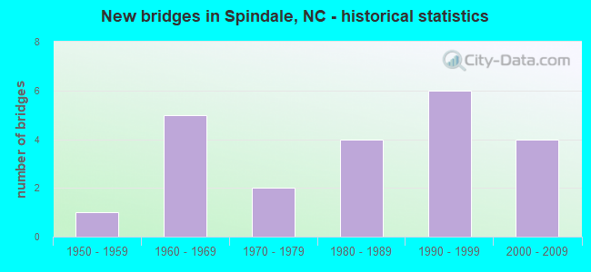
- New bridges - historical statistics
- 11950-1959
- 51960-1969
- 21970-1979
- 41980-1989
- 61990-1999
- 42000-2009


- Bridge Condition - Deck
- 58.3%Good
- 41.7%Satisfactory

- Bridge Condition - Superstructure
- 58.3%Good
- 41.7%Satisfactory

- Bridge Condition - Substructure
- 58.3%Good
- 8.3%Satisfactory
- 8.3%Fair
- 16.7%Poor
- 8.3%Serious

- Bridge Condition - Channel
- 91.7%Good
- 8.3%Satisfactory

- Bridge Condition - Culverts
- 50.0%Good
- 50.0%Satisfactory
Find on map >> Show street view
Structure Number: 1610011, Location: 1 MI.W.JCT.SR1194 (Lat: 35.330906, Lng: -82.031517), Route carried "on" structure: State highway 108, Year Built: 1986, Status: Open, Structure Length: 9.75m (31.99ft), Average Daily Traffic: 1,100 (year 2019), Truck Traffic: 7%, Average Future Daily Traffic: 2,200 (year 2040), Design Load: HS 20+Mod, Features Intersected: BROAD RIVER
Minimum Vertical Clearance: 30+ m (98+ ft), Kilometerpoint: 0.000, Lanes on structure: 2, Owner: State Highway Agency, Approaching Roadway Width: 7.3m (24.0ft), Material/Design: Prestressed concrete, Design/Construction: Stringer/Multi-beam, Number Of Spans In Main Unit: 5, Length of Maximum Span: 18.8m (61.7ft), Curb-To-Curb Width: 9.1m (29.9ft), Out-to-Out Width: 10.0m (32.8ft)
Condition: Deck: Good, Superstructure: Good, Substructure: Good, Channel: Good, Operating Rating: 78.0 metric tons, Method Used To Determine Operating Rating: Load Factor (LF), Inventory Rating: 30.8 metric tons, Method Used To Determine Inventory Rating: Load Factor (LF), Structural Evaluation: Better than present minimum criteria, Deck Geometry: Somewhat better than minimum adequacy, Waterway Adequacy: Better than present minimum criteria, Approach Roadway Alignment: Equal to present desirable criteria, Designated Inspection Frequency: Every 24 months, Underwater Inspection Frequency: Every 60 months, Inspection Date: August 2021, Underwater Inspection Date: January 2021, Deck Structure Type: Concrete Cast-file-Place, Wearing Surface/Protective System: Wearing Surface: Monolithic Concrete
Find on map >> Show street view
Structure Number: 1610014, Location: .1 MI.N.JCT.SR2191 (Lat: 35.342089, Lng: -81.919553), Route carried "on" structure: State highway 2169, Year Built: 1968, Status: Open, Structure Length: 6.58m (21.59ft), Average Daily Traffic: 9,900 (year 2013), Truck Traffic: 6%, Average Future Daily Traffic: 19,800 (year 2040), Design Load: HS 20+Mod, Features Intersected: US74A
Minimum Vertical Clearance: 30+ m (98+ ft), Kilometerpoint: 0.000, Lanes on structure: 2, Lanes under structure: 4, Owner: State Highway Agency, Approaching Roadway Width: 14.3m (46.9ft), Skew: 20 degrees, Material/Design: Steel, Design/Construction: Stringer/Multi-beam, Number Of Spans In Main Unit: 4, Length of Maximum Span: 21.0m (68.9ft), Curb-To-Curb Width: 16.2m (53.1ft), Out-to-Out Width: 17.0m (55.8ft)
Condition: Deck: Satisfactory, Superstructure: Satisfactory, Substructure: Fair, Operating Rating: 63.5 metric tons, Method Used To Determine Operating Rating: Load Factor (LF), Inventory Rating: 38.1 metric tons, Method Used To Determine Inventory Rating: Load Factor (LF), Structural Evaluation: Somewhat better than minimum adequacy, Deck Geometry: Superior to present desirable criteria, Underclear: Equal to present minimum criteria, Approach Roadway Alignment: Equal to present desirable criteria, Designated Inspection Frequency: Every 24 months, Inspection Date: July 2021, Deck Structure Type: Concrete Cast-file-Place, Wearing Surface/Protective System: Wearing Surface: Epoxy Overlay, Membrane: Epoxy
Find on map >> Show street view
Structure Number: 1610122, Location: .5 MI.E.JCT.SR1592 (Lat: 35.396850, Lng: -81.926664), Route carried "on" structure: US 64, Year Built: 2001, Status: Open, Structure Length: 5.12m (16.80ft), Average Daily Traffic: 5,100 (year 2015), Truck Traffic: 8%, Average Future Daily Traffic: 10,200 (year 2040), Design Load: HS 20+Mod, Features Intersected: CATHEY'S CREEK
Minimum Vertical Clearance: 30+ m (98+ ft), Kilometerpoint: 0.000, Lanes on structure: 2, Owner: State Highway Agency, Approaching Roadway Width: 12.1m (39.7ft), Material/Design: Prestressed concrete continuous, Design/Construction: Stringer/Multi-beam, Number Of Spans In Main Unit: 3, Length of Maximum Span: 17.9m (58.7ft), Curb-To-Curb Width: 11.9m (39.0ft), Out-to-Out Width: 13.0m (42.7ft)
Condition: Deck: Good, Superstructure: Good, Substructure: Good, Channel: Good, Operating Rating: 69.8 metric tons, Method Used To Determine Operating Rating: Load Factor (LF), Inventory Rating: 41.7 metric tons, Method Used To Determine Inventory Rating: Load Factor (LF), Structural Evaluation: Better than present minimum criteria, Deck Geometry: Somewhat better than minimum adequacy, Waterway Adequacy: Better than present minimum criteria, Approach Roadway Alignment: Equal to present desirable criteria, Designated Inspection Frequency: Every 24 months, Inspection Date: July 2021, Deck Structure Type: Concrete Cast-file-Place, Wearing Surface/Protective System: Wearing Surface: Monolithic Concrete, Deck Protection: Epoxy Coated Reinforcing
Find on map >> Show street view
Structure Number: 1610126, Location: 0.2 MI.W.JCT.SR1556 (Lat: 35.429256, Lng: -81.897167), Route carried "on" structure: US 64, Year Built: 2001, Status: Open, Structure Length: 4.60m (15.09ft), Average Daily Traffic: 4,100 (year 2019), Truck Traffic: 8%, Average Future Daily Traffic: 8,200 (year 2040), Design Load: HS 20+Mod, Features Intersected: CLINCHFIELD RR
Minimum Vertical Clearance: 30+ m (98+ ft), Kilometerpoint: 0.000, Lanes on structure: 2, Owner: State Highway Agency, Approaching Roadway Width: 11.8m (38.7ft), Skew: 3 degrees, Material/Design: Steel, Design/Construction: Stringer/Multi-beam, Number Of Spans In Main Unit: 1, Length of Maximum Span: 45.4m (149.0ft), Curb-To-Curb Width: 11.8m (38.7ft), Out-to-Out Width: 12.9m (42.3ft)
Condition: Deck: Good, Superstructure: Good, Substructure: Good, Operating Rating: 79.8 metric tons, Method Used To Determine Operating Rating: Load Factor (LF), Inventory Rating: 47.1 metric tons, Method Used To Determine Inventory Rating: Load Factor (LF), Structural Evaluation: Better than present minimum criteria, Deck Geometry: Somewhat better than minimum adequacy, Underclear: Meets minimum limits, Approach Roadway Alignment: Equal to present desirable criteria, Designated Inspection Frequency: Every 24 months, Inspection Date: June 2021, Deck Structure Type: Concrete Cast-file-Place, Wearing Surface/Protective System: Wearing Surface: Monolithic Concrete
Find on map >> Show street view
Structure Number: 1610127, Location: .3 MI.E.JCT.SR1556 (Lat: 35.429992, Lng: -81.896561), Route carried "on" structure: US 64, Year Built: 2001, Status: Open, Structure Length: 7.95m (26.08ft), Average Daily Traffic: 4,100 (year 2019), Truck Traffic: 8%, Average Future Daily Traffic: 8,200 (year 2040), Design Load: HS 20+Mod, Features Intersected: SECOND BROAD RIVER
Minimum Vertical Clearance: 30+ m (98+ ft), Kilometerpoint: 0.000, Lanes on structure: 2, Base Highway Network: Yes (Inventory Route: 2, Subroute: 64), Owner: State Highway Agency, Approaching Roadway Width: 7.6m (24.9ft), Skew: 2 degrees, Material/Design: Prestressed concrete, Design/Construction: Stringer/Multi-beam, Number Of Spans In Main Unit: 3, Length of Maximum Span: 27.1m (88.9ft), Curb-To-Curb Width: 11.8m (38.7ft), Out-to-Out Width: 12.9m (42.3ft)
Condition: Deck: Good, Superstructure: Good, Substructure: Good, Channel: Good, Operating Rating: 87.0 metric tons, Method Used To Determine Operating Rating: Load Factor (LF), Inventory Rating: 39.9 metric tons, Method Used To Determine Inventory Rating: Load Factor (LF), Structural Evaluation: Better than present minimum criteria, Deck Geometry: Somewhat better than minimum adequacy, Waterway Adequacy: Better than present minimum criteria, Approach Roadway Alignment: Equal to present desirable criteria, Designated Inspection Frequency: Every 24 months, Inspection Date: June 2021, Deck Structure Type: Concrete Cast-file-Place, Wearing Surface/Protective System: Wearing Surface: Monolithic Concrete
Find on map >> Show street view
Structure Number: 1610159, Location: .1 MI.W.JCT.SR1510 (Lat: 35.380442, Lng: -81.889867), Route carried "on" structure: State highway 1548, Year Built: 1971, Status: Posted for load, Structure Length: 2.77m (9.09ft), Average Daily Traffic: 500 (year 2015), Truck Traffic: 6%, Average Future Daily Traffic: 1,000 (year 2040), Design Load: H 10, Features Intersected: HOLLANDS CREEK
Minimum Vertical Clearance: 30+ m (98+ ft), Kilometerpoint: 0.000, Lanes on structure: 2, Owner: State Highway Agency, Approaching Roadway Width: 6.0m (19.7ft), Material/Design: Prestressed concrete, Design/Construction: Channel Beam, Number Of Spans In Main Unit: 3, Length of Maximum Span: 8.8m (28.9ft), Curb or Sidewalk Widths: Left: 0.1m (0.3ft), Right: 0.1m (0.3ft), Curb-To-Curb Width: 7.2m (23.6ft), Out-to-Out Width: 7.7m (25.3ft)
Condition: Deck: Satisfactory, Superstructure: Satisfactory, Substructure: Poor, Channel: Good, Operating Rating: 36.2 metric tons, Method Used To Determine Operating Rating: Allowable Stress (AS), Inventory Rating: 18.1 metric tons, Method Used To Determine Inventory Rating: Allowable Stress (AS), Structural Evaluation: Meets minimum limits, Deck Geometry: Meets minimum limits, Waterway Adequacy: Better than present minimum criteria, Approach Roadway Alignment: Equal to present minimum criteria, Bridge Posting: Required (Relationship of Operating Rating to Maximum Legal Load: 0.1 - 9.9% below), Designated Inspection Frequency: Every 24 months, Inspection Date: June 2021, Deck Structure Type: Concrete Cast-file-Place, Wearing Surface/Protective System: Wearing Surface: Bituminous
Find on map >> Show street view
Structure Number: 1610162, Location: .6 MI.E.JCT.SR1548 (Lat: 35.392558, Lng: -81.915756), Route carried "on" structure: State highway 1538, Year Built: 1967, Status: Open, Structure Length: 4.14m (13.58ft), Average Daily Traffic: 1,650 (year 2015), Truck Traffic: 6%, Average Future Daily Traffic: 3,300 (year 2040), Design Load: HS 15, Features Intersected: CATHEYS CREEK
Minimum Vertical Clearance: 30+ m (98+ ft), Kilometerpoint: 0.000, Lanes on structure: 2, Owner: State Highway Agency, Approaching Roadway Width: 6.7m (22.0ft), Skew: 3 degrees, Material/Design: Prestressed concrete, Design/Construction: Slab, Number Of Spans In Main Unit: 3, Length of Maximum Span: 13.4m (44.0ft), Curb-To-Curb Width: 7.2m (23.6ft), Out-to-Out Width: 7.5m (24.6ft)
Condition: Deck: Satisfactory, Superstructure: Satisfactory, Substructure: Poor, Channel: Good, Operating Rating: 46.2 metric tons, Method Used To Determine Operating Rating: Load Factor (LF), Inventory Rating: 27.2 metric tons, Method Used To Determine Inventory Rating: Load Factor (LF), Structural Evaluation: Meets minimum limits, Deck Geometry: High priority of corrective action, Waterway Adequacy: Better than present minimum criteria, Approach Roadway Alignment: Equal to present minimum criteria, Designated Inspection Frequency: Every 24 months, Inspection Date: July 2021, Deck Structure Type: Concrete Precast Panels, Wearing Surface/Protective System: Wearing Surface: Bituminous
Find on map >> Show street view
Structure Number: 1610181, Location: .1 MI.W.JCT.SR2190 (Lat: 35.318372, Lng: -81.923753), Route carried "on" structure: State highway 2196, Year Built: 1995, Status: Open, Structure Length: 0.79m (2.59ft), Average Daily Traffic: 200 (year 2019), Truck Traffic: 7%, Average Future Daily Traffic: 400 (year 2040), Design Load: HS 20+Mod, Features Intersected: UT TO LONG BRANCH
Minimum Vertical Clearance: 30+ m (98+ ft), Kilometerpoint: 0.000, Lanes on structure: 2, Owner: State Highway Agency, Approaching Roadway Width: 5.4m (17.7ft), Skew: 4 degrees, Material/Design: Steel, Design/Construction: Culvert, Number Of Spans In Main Unit: 2, Length of Maximum Span: 2.4m (7.9ft)
Condition: Channel: Good, Culverts: Good, Operating Rating: 89.8 metric tons, Method Used To Determine Operating Rating: Load and Resistance Factor (LRFR), Inventory Rating: 89.8 metric tons, Method Used To Determine Inventory Rating: Load and Resistance Factor (LRFR), Structural Evaluation: Better than present minimum criteria, Waterway Adequacy: Better than present minimum criteria, Approach Roadway Alignment: Equal to present desirable criteria, Designated Inspection Frequency: Every 24 months, Inspection Date: March 2021
Find on map >> Show street view
Structure Number: 161028, Location: .4 MI.S.JCT.SR1112 (Lat: 35.199239, Lng: -81.900625), Route carried "on" structure: State highway 1111, Year Built: 1997, Status: Open, Structure Length: 3.10m (10.17ft), Average Daily Traffic: 560 (year 2014), Truck Traffic: 6%, Average Future Daily Traffic: 1,120 (year 2040), Design Load: HS 20+Mod, Features Intersected: MCKINNEY CREEK
Minimum Vertical Clearance: 30+ m (98+ ft), Kilometerpoint: 0.000, Lanes on structure: 2, Owner: State Highway Agency, Approaching Roadway Width: 8.2m (26.9ft), Skew: 1 degrees, Material/Design: Prestressed concrete, Design/Construction: Slab, Number Of Spans In Main Unit: 3, Length of Maximum Span: 11.5m (37.7ft), Curb-To-Curb Width: 8.2m (26.9ft), Out-to-Out Width: 9.1m (29.9ft)
Condition: Deck: Good, Superstructure: Good, Substructure: Good, Channel: Good, Operating Rating: 80.7 metric tons, Method Used To Determine Operating Rating: Load Factor (LF), Inventory Rating: 48.0 metric tons, Method Used To Determine Inventory Rating: Load Factor (LF), Structural Evaluation: Better than present minimum criteria, Deck Geometry: Somewhat better than minimum adequacy, Waterway Adequacy: Better than present minimum criteria, Approach Roadway Alignment: Equal to present desirable criteria, Designated Inspection Frequency: Every 24 months, Inspection Date: March 2021, Deck Structure Type: Concrete Precast Panels, Wearing Surface/Protective System: Wearing Surface: Bituminous
Find on map >> Show street view
Structure Number: 1610289, Location: .04 MI.E.JCT.SR1546 (Lat: 35.383906, Lng: -81.919869), Route carried "on" structure: State highway 1538, Year Built: 2002, Status: Open, Structure Length: 3.59m (11.78ft), Average Daily Traffic: 1,600 (year 2015), Truck Traffic: 7%, Average Future Daily Traffic: 3,200 (year 2040), Design Load: HS 20+Mod, Features Intersected: HOLLANDS CREEK
Minimum Vertical Clearance: 30+ m (98+ ft), Kilometerpoint: 0.000, Lanes on structure: 2, Owner: State Highway Agency, Approaching Roadway Width: 6.4m (21.0ft), Skew: 3 degrees, Material/Design: Prestressed concrete, Design/Construction: Slab, Number Of Spans In Main Unit: 3, Length of Maximum Span: 14.6m (47.9ft), Curb-To-Curb Width: 9.0m (29.5ft), Out-to-Out Width: 10.0m (32.8ft)
Condition: Deck: Good, Superstructure: Good, Substructure: Good, Channel: Good, Operating Rating: 73.4 metric tons, Method Used To Determine Operating Rating: Load Factor (LF), Inventory Rating: 43.5 metric tons, Method Used To Determine Inventory Rating: Load Factor (LF), Structural Evaluation: Better than present minimum criteria, Deck Geometry: Somewhat better than minimum adequacy, Waterway Adequacy: Better than present minimum criteria, Approach Roadway Alignment: Equal to present desirable criteria, Designated Inspection Frequency: Every 24 months, Inspection Date: July 2021, Deck Structure Type: Concrete Precast Panels, Wearing Surface/Protective System: Wearing Surface: Bituminous
Find on map >> Show street view
Structure Number: 161029, Location: .03 MI.W.JCT.SR1546 (Lat: 35.383900, Lng: -81.921403), Route carried "on" structure: State highway 1538, Year Built: 1978, Status: Open, Structure Length: 0.91m (2.99ft), Average Daily Traffic: 1,300 (year 2019), Truck Traffic: 7%, Average Future Daily Traffic: 2,600 (year 2040), Design Load: HS 20, Features Intersected: UT TO HOLLANDS CREEK
Minimum Vertical Clearance: 30+ m (98+ ft), Kilometerpoint: 0.000, Lanes on structure: 2, Owner: State Highway Agency, Approaching Roadway Width: 6.4m (21.0ft), Skew: 4 degrees, Material/Design: Steel, Design/Construction: Culvert, Number Of Spans In Main Unit: 2, Length of Maximum Span: 2.4m (7.9ft)
Condition: Channel: Good, Culverts: Satisfactory, Operating Rating: 89.8 metric tons, Method Used To Determine Operating Rating: Load and Resistance Factor (LRFR), Inventory Rating: 89.8 metric tons, Method Used To Determine Inventory Rating: Load and Resistance Factor (LRFR), Structural Evaluation: Equal to present minimum criteria, Waterway Adequacy: Better than present minimum criteria, Approach Roadway Alignment: Equal to present desirable criteria, Designated Inspection Frequency: Every 24 months, Inspection Date: May 2021
Find on map >> Show street view
Structure Number: 1610293, Location: .15 MI.N.JCT.SR1591 (Lat: 35.378683, Lng: -81.914925), Route carried "on" structure: State highway 1547, Year Built: 1967, Status: Temporarily open, Structure Length: 2.31m (7.58ft), Average Daily Traffic: 640 (year 2012), Truck Traffic: 7%, Average Future Daily Traffic: 1,280 (year 2040), Features Intersected: HOLLANDS CREEK
Minimum Vertical Clearance: 30+ m (98+ ft), Kilometerpoint: 0.000, Lanes on structure: 2, Owner: State Highway Agency, Approaching Roadway Width: 6.4m (21.0ft), Material/Design: Prestressed concrete, Design/Construction: Channel Beam, Number Of Spans In Main Unit: 3, Length of Maximum Span: 7.3m (24.0ft), Curb-To-Curb Width: 7.4m (24.3ft), Out-to-Out Width: 7.7m (25.3ft)
Condition: Deck: Good, Superstructure: Satisfactory, Substructure: Serious, Channel: Good, Operating Rating: 56.2 metric tons, Method Used To Determine Operating Rating: Load Factor (LF), Inventory Rating: 30.8 metric tons, Method Used To Determine Inventory Rating: Load Factor (LF), Structural Evaluation: High priority of corrective action, Deck Geometry: Meets minimum limits, Waterway Adequacy: Better than present minimum criteria, Approach Roadway Alignment: Equal to present desirable criteria, Designated Inspection Frequency: Every 24 months, Inspection Date: August 2021, Deck Structure Type: Concrete Precast Panels, Wearing Surface/Protective System: Wearing Surface: Bituminous
Find on map >> Show street view
Structure Number: 1610408, Location: 0.35 MI.N.JCT.SR2171 (Lat: 35.315097, Lng: -81.921642), Route carried "on" structure: State highway 2197, Year Built: 1998, Status: Open, Structure Length: 0.64m (2.10ft), Average Daily Traffic: 700 (year 2016), Truck Traffic: 6%, Average Future Daily Traffic: 1,400 (year 2040), Design Load: HS 20+Mod, Features Intersected: UT TO LONG BRANCH
Minimum Vertical Clearance: 30+ m (98+ ft), Kilometerpoint: 0.000, Lanes on structure: 2, Owner: State Highway Agency, Approaching Roadway Width: 5.4m (17.7ft), Material/Design: Steel, Design/Construction: Culvert, Number Of Spans In Main Unit: 2, Length of Maximum Span: 2.7m (8.9ft)
Condition: Channel: Good, Culverts: Good, Operating Rating: 89.8 metric tons, Method Used To Determine Operating Rating: Load and Resistance Factor (LRFR), Inventory Rating: 89.8 metric tons, Method Used To Determine Inventory Rating: Load and Resistance Factor (LRFR), Structural Evaluation: Better than present minimum criteria, Waterway Adequacy: Better than present minimum criteria, Approach Roadway Alignment: Equal to present desirable criteria, Designated Inspection Frequency: Every 24 months, Inspection Date: March 2021
Find on map >> Show street view
Structure Number: 1610621, Location: .65 MI.E.JCT.SR2193 (Lat: 35.346142, Lng: -81.946467), Route carried "on" structure: State highway 2201, Year Built: 1950, Status: Open, Structure Length: 0.64m (2.10ft), Average Daily Traffic: 4,400 (year 2014), Truck Traffic: 7%, Average Future Daily Traffic: 8,800 (year 2040), Design Load: HS 20, Features Intersected: STONECUTTER CREEK
Minimum Vertical Clearance: 30+ m (98+ ft), Kilometerpoint: 0.000, Lanes on structure: 2, Owner: State Highway Agency, Approaching Roadway Width: 6.4m (21.0ft), Skew: 4 degrees, Material/Design: Concrete continuous, Design/Construction: Culvert, Number Of Spans In Main Unit: 2, Length of Maximum Span: 2.1m (6.9ft)
Condition: Channel: Satisfactory, Culverts: Satisfactory, Operating Rating: 41.7 metric tons, Method Used To Determine Operating Rating: Field evaluation and documented engineering judgment, Inventory Rating: 32.6 metric tons, Method Used To Determine Inventory Rating: Field evaluation and documented engineering judgment, Structural Evaluation: Equal to present minimum criteria, Waterway Adequacy: Better than present minimum criteria, Approach Roadway Alignment: Equal to present desirable criteria, Designated Inspection Frequency: Every 24 months, Inspection Date: Febuary 2021
Find on map >> Show street view
Structure Number: 1610631, Location: .01 MI.S.JCT.SR2171 (Lat: 35.307625, Lng: -81.922472), Route carried "on" structure: US 221, Year Built: 1989, Year Reconstructed: 2015, Status: Open, Structure Length: 8.04m (26.38ft), Average Daily Traffic: 6,500 (year 2015), Truck Traffic: 8%, Average Future Daily Traffic: 13,000 (year 2040), Design Load: HS 20+Mod, Features Intersected: US74
Minimum Vertical Clearance: 30+ m (98+ ft), Kilometerpoint: 0.000, Lanes on structure: 4, Lanes under structure: 4, Base Highway Network: Yes (Inventory Route: 2, Subroute: 21), Owner: State Highway Agency, Approaching Roadway Width: 22.5m (73.8ft), Skew: 24 degrees, Material/Design: Prestressed concrete, Design/Construction: Stringer/Multi-beam, Number Of Spans In Main Unit: 4, Length of Maximum Span: 24.6m (80.7ft), Curb-To-Curb Width: 24.3m (79.7ft), Out-to-Out Width: 25.2m (82.7ft)
Condition: Deck: Satisfactory, Superstructure: Satisfactory, Substructure: Good, Operating Rating: 72.5 metric tons, Method Used To Determine Operating Rating: Load Factor (LF), Inventory Rating: 41.7 metric tons, Method Used To Determine Inventory Rating: Load Factor (LF), Structural Evaluation: Equal to present minimum criteria, Deck Geometry: Superior to present desirable criteria, Underclear: Somewhat better than minimum adequacy, Approach Roadway Alignment: Equal to present desirable criteria, Designated Inspection Frequency: Every 24 months, Inspection Date: July 2021, Deck Structure Type: Concrete Cast-file-Place, Wearing Surface/Protective System: Wearing Surface: Monolithic Concrete, Deck Protection: Epoxy Coated Reinforcing
Find on map >> Show street view
Structure Number: 1610637, Location: 1.2 MI.S.JCT.US221 (Lat: 35.309292, Lng: -81.938553), Route carried "on" structure: State highway 1004, Year Built: 1992, Status: Open, Structure Length: 6.33m (20.77ft), Average Daily Traffic: 3,100 (year 2014), Truck Traffic: 6%, Average Future Daily Traffic: 6,200 (year 2040), Design Load: HS 20+Mod, Features Intersected: US74
Minimum Vertical Clearance: 30+ m (98+ ft), Kilometerpoint: 0.000, Lanes on structure: 2, Lanes under structure: 4, Owner: State Highway Agency, Approaching Roadway Width: 9.4m (30.8ft), Material/Design: Prestressed concrete, Design/Construction: Stringer/Multi-beam, Number Of Spans In Main Unit: 4, Length of Maximum Span: 18.8m (61.7ft), Curb-To-Curb Width: 9.2m (30.2ft), Out-to-Out Width: 10.2m (33.5ft)
Condition: Deck: Satisfactory, Superstructure: Good, Substructure: Satisfactory, Operating Rating: 74.3 metric tons, Method Used To Determine Operating Rating: Load Factor (LF), Inventory Rating: 39.9 metric tons, Method Used To Determine Inventory Rating: Load Factor (LF), Structural Evaluation: Equal to present minimum criteria, Deck Geometry: Meets minimum limits, Underclear: Equal to present minimum criteria, Approach Roadway Alignment: Equal to present desirable criteria, Designated Inspection Frequency: Every 24 months, Inspection Date: July 2021, Deck Structure Type: Concrete Cast-file-Place, Wearing Surface/Protective System: Wearing Surface: Monolithic Concrete, Deck Protection: Epoxy Coated Reinforcing
Find on map >> Show street view
Structure Number: 1610014, Location: .1 MI.N.JCT.SR2191 (Lat: 35.342089, Lng: -81.919553), Route carried "under" structure: Alternate US 74, Year Built: 1968, Structure Length: 0. m, Average Daily Traffic: 10,250 (year 2015), Truck Traffic: 12%, Features Intersected: SR2169
Minimum Vertical Clearance: 4.93m (16.17ft), Kilometerpoint: 0.000, Lanes on structure: 2, Lanes under structure: 2, Material/Design: Steel, Design/Construction: Stringer/Multi-beam, Length of Maximum Span: 21.0m (68.9ft)
Find on map >> Show street view
Structure Number: 1610014, Location: .1 MI.N.JCT.SR2191 (Lat: 35.342089, Lng: -81.919553), Route carried "under" structure: Alternate US 74, Year Built: 1968, Structure Length: 0. m, Average Daily Traffic: 10,250 (year 2015), Truck Traffic: 12%, Features Intersected: SR2169
Minimum Vertical Clearance: 4.63m (15.19ft), Kilometerpoint: 0.000, Lanes on structure: 2, Lanes under structure: 2, Material/Design: Steel, Design/Construction: Stringer/Multi-beam, Length of Maximum Span: 21.0m (68.9ft)
Find on map >> Show street view
Structure Number: 1610631, Location: .01 MI.S.JCT.SR2171 (Lat: 35.307625, Lng: -81.922472), Route carried "under" structure: US 74, Year Built: 1989, Structure Length: 0. m, Average Daily Traffic: 7,500 (year 2015), Truck Traffic: 14%, Features Intersected: US221
Minimum Vertical Clearance: 5.53m (18.14ft), Kilometerpoint: 0.000, Lanes on structure: 4, Lanes under structure: 2, Material/Design: Prestressed concrete, Design/Construction: Stringer/Multi-beam, Length of Maximum Span: 24.6m (80.7ft)
Find on map >> Show street view
Structure Number: 1610631, Location: .01 MI.S.JCT.SR2171 (Lat: 35.307625, Lng: -81.922472), Route carried "under" structure: US 74, Year Built: 1989, Structure Length: 0. m, Average Daily Traffic: 7,500 (year 2015), Truck Traffic: 14%, Features Intersected: US221
Minimum Vertical Clearance: 4.93m (16.17ft), Kilometerpoint: 0.000, Lanes on structure: 4, Lanes under structure: 2, Material/Design: Prestressed concrete, Design/Construction: Stringer/Multi-beam, Length of Maximum Span: 24.6m (80.7ft)
Find on map >> Show street view
Structure Number: 1610637, Location: 1.2 MI.S.JCT.US221 (Lat: 35.309292, Lng: -81.938553), Route carried "under" structure: US 74, Year Built: 1992, Structure Length: 0. m, Average Daily Traffic: 7,500 (year 2015), Truck Traffic: 14%, Features Intersected: SR1004
Minimum Vertical Clearance: 5.56m (18.24ft), Kilometerpoint: 0.000, Lanes on structure: 2, Lanes under structure: 2, Material/Design: Prestressed concrete, Design/Construction: Stringer/Multi-beam, Length of Maximum Span: 18.8m (61.7ft)
Find on map >> Show street view
Structure Number: 1610637, Location: 1.2 MI.S.JCT.US221 (Lat: 35.309292, Lng: -81.938553), Route carried "under" structure: US 74, Year Built: 1992, Structure Length: 0. m, Average Daily Traffic: 7,500 (year 2015), Truck Traffic: 14%, Features Intersected: SR1004
Minimum Vertical Clearance: 6.15m (20.18ft), Kilometerpoint: 0.000, Lanes on structure: 2, Lanes under structure: 2, Material/Design: Prestressed concrete, Design/Construction: Stringer/Multi-beam, Length of Maximum Span: 18.8m (61.7ft)