Bridge Statistics for Spring House, Pennsylvania (PA)
Condition, Traffic, Stress, Structural Evaluation, Project Costs
- National Bridge Inventory (NBI) Statistics
- 18Number of bridges
- 82ft / 25.5mTotal length
- $3,116,000Total costs
- 310,121Total average daily traffic
- 13,192Total average daily truck traffic
- National Bridge Inventory (NBI) Registered Bridges for Spring House
- No street view available for this location
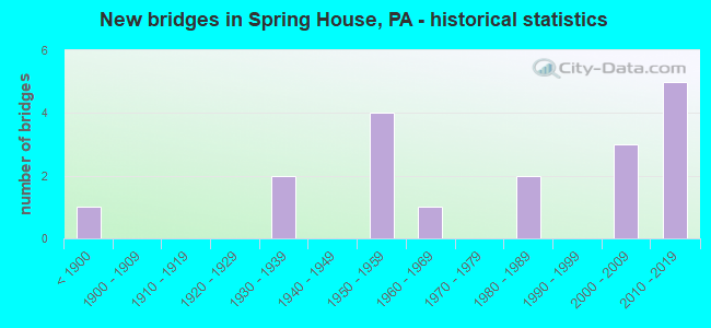
- New bridges - historical statistics
- 1Before 1900
- 21930-1939
- 41950-1959
- 11960-1969
- 21980-1989
- 32000-2009
- 52010-2019

- Reconstructed bridges - Historical Statistics
- 11970-1979
- 01980-1989
- 01990-1999
- 02000-2009
- 22010-2019


- Bridge Condition - Deck
- 50.0%Very good
- 33.3%Good
- 16.7%Satisfactory

- Bridge Condition - Superstructure
- 62.5%Very good
- 12.5%Satisfactory
- 25.0%Fair

- Bridge Condition - Substructure
- 37.5%Very good
- 25.0%Good
- 12.5%Satisfactory
- 12.5%Fair
- 12.5%Poor

- Bridge Condition - Channel
- 33.3%Fair
- 66.7%Poor

- Bridge Condition - Culverts
- 33.3%Satisfactory
- 66.7%Fair
Find on map >> Show street view
Structure Number: 27391, Location: NE OF AMBLER 23J11/3257G3 (Lat: 40.172867, Lng: -75.211100), Route carried "on" structure: State highway 309, Year Built: 1958, Year Reconstructed: 2010, Status: Open, Structure Length: 3.96m (12.99ft), Average Daily Traffic: 65,172 (year 2022), Truck Traffic: 5%, Average Future Daily Traffic: 65,331 (year 2032), Design Load: HS 25 or greater, Features Intersected: TENNIS AVENUE
Minimum Vertical Clearance: 30+ m (98+ ft), Kilometerpoint: 15.498, Lanes on structure: 2, Lanes under structure: 2, Base Highway Network: Yes, Owner: State Highway Agency, Approaching Roadway Width: 12.2m (40.0ft), Skew: 30 degrees, Material/Design: Steel continuous, Design/Construction: Stringer/Multi-beam, Number Of Spans In Main Unit: 3, Length of Maximum Span: 17.4m (57.1ft), Curb or Sidewalk Widths: Left: 0.1m (0.3ft), Right: 0.1m (0.3ft), Curb-To-Curb Width: 12.2m (40.0ft), Out-to-Out Width: 28.5m (93.5ft)
Condition: Deck: Good, Superstructure: Very good, Substructure: Good, Operating Rating: 97.1 metric tons, Method Used To Determine Operating Rating: Load Factor (LF), Inventory Rating: 58.1 metric tons, Method Used To Determine Inventory Rating: Load Factor (LF), Structural Evaluation: Better than present minimum criteria, Deck Geometry: Somewhat better than minimum adequacy, Underclear: High priority of corrective action, Approach Roadway Alignment: Equal to present desirable criteria, Length Of Structure Improvement: 4.70m (15.42ft), Designated Inspection Frequency: Every 24 months, Inspection Date: August 2020, Bridge Improvement Cost: $110,000, Roadway Improvement Cost: $324,000, Total Project Cost: $1,486,000, Deck Structure Type: Concrete Cast-file-Place, Wearing Surface/Protective System: Wearing Surface: Monolithic Concrete, Deck Protection: Epoxy Coated Reinforcing
Find on map >> Show street view
Structure Number: 27393, Location: SPRING HOUSE 23J08 (Lat: 40.190367, Lng: -75.215200), Route carried "on" structure: State highway 309, Year Built: 1958, Year Reconstructed: 2010, Status: Open, Structure Length: 3.90m (12.80ft), Average Daily Traffic: 48,495 (year 2021), Truck Traffic: 5%, Average Future Daily Traffic: 50,851 (year 2032), Design Load: HS 25 or greater, Features Intersected: MCKEAN ROAD & PATH
Minimum Vertical Clearance: 30+ m (98+ ft), Kilometerpoint: 17.667, Lanes on structure: 2, Lanes under structure: 2, Base Highway Network: Yes, Owner: State Highway Agency, Approaching Roadway Width: 12.5m (41.0ft), Skew: 30 degrees, Material/Design: Steel continuous, Design/Construction: Stringer/Multi-beam, Number Of Spans In Main Unit: 3, Length of Maximum Span: 17.4m (57.1ft), Curb or Sidewalk Widths: Left: 0.1m (0.3ft), Right: 0.1m (0.3ft), Curb-To-Curb Width: 12.3m (40.4ft), Out-to-Out Width: 25.9m (85.0ft)
Condition: Deck: Very good, Superstructure: Very good, Substructure: Good, Inventory Rating: 59.9 metric tons, Method Used To Determine Inventory Rating: Load Factor (LF), Structural Evaluation: Better than present minimum criteria, Deck Geometry: Somewhat better than minimum adequacy, Underclear: High priority of corrective action, Approach Roadway Alignment: Equal to present desirable criteria, Length Of Structure Improvement: 4.80m (15.75ft), Designated Inspection Frequency: Every 24 months, Inspection Date: August 2020, Bridge Improvement Cost: $112,000, Roadway Improvement Cost: $329,000, Total Project Cost: $1,507,000, Deck Structure Type: Concrete Cast-file-Place, Wearing Surface/Protective System: Wearing Surface: Monolithic Concrete, Deck Protection: Epoxy Coated Reinforcing
Find on map >> Show street view
Structure Number: 27625, Location: 1 MILE TO PENLLYN 23G08 (Lat: 40.186600, Lng: -75.227494), Route carried "on" structure: State highway , Year Built: 1934, Status: Open, Structure Length: 0.70m (2.30ft), Average Daily Traffic: 8,633 (year 2022), Truck Traffic: 1%, Average Future Daily Traffic: 17,874 (year 2032), Design Load: H 20, Features Intersected: WILLOW RUN, Facility Carried by Structure: BETHLEHEM PIKE
Minimum Vertical Clearance: 30+ m (98+ ft), Kilometerpoint: 11.153, Lanes on structure: 2, Owner: State Highway Agency, Approaching Roadway Width: 15.2m (49.9ft), Skew: 6 degrees, Material/Design: Concrete, Design/Construction: Arch - Deck, Number Of Spans In Main Unit: 1, Length of Maximum Span: 7.0m (23.0ft), Curb-To-Curb Width: 15.2m (49.9ft), Out-to-Out Width: 15.8m (51.8ft)
Condition: Superstructure: Fair, Substructure: Fair, Channel: Poor, Operating Rating: 78.9 metric tons, Method Used To Determine Operating Rating: Field evaluation and documented engineering judgment, Inventory Rating: 39.0 metric tons, Method Used To Determine Inventory Rating: Field evaluation and documented engineering judgment, Structural Evaluation: Somewhat better than minimum adequacy, Deck Geometry: Superior to present desirable criteria, Waterway Adequacy: Equal to present minimum criteria, Approach Roadway Alignment: Equal to present desirable criteria, Length Of Structure Improvement: 1.20m (3.94ft), Designated Inspection Frequency: Every 24 months, Inspection Date: June 2020, Bridge Improvement Cost: $9,000, Roadway Improvement Cost: $27,000, Total Project Cost: $123,000
Find on map >> Show street view
Structure Number: 27946, Location: 0.9 Mi SE US-202 3256-K1 (Lat: 40.186447, Lng: -75.255025), Route carried "on" structure: County highway , Year Built: 1839, Year Reconstructed: 1977, Status: Open, Structure Length: 2.19m (7.19ft), Average Daily Traffic: 6,063 (year 2019), Average Future Daily Traffic: 6,841 (year 2018), Features Intersected: WISSAHICKON CREEK, Facility Carried by Structure: PLYMOUTH ROAD
Minimum Vertical Clearance: 30+ m (98+ ft), Kilometerpoint: 0.000, Lanes on structure: 2, Owner: County Highway Agency, Approaching Roadway Width: 7.9m (25.9ft), Material/Design: Masonry, Design/Construction: Arch - Deck, Number Of Spans In Main Unit: 3, Length of Maximum Span: 6.7m (22.0ft), Curb-To-Curb Width: 7.8m (25.6ft), Out-to-Out Width: 9.1m (29.9ft)
Condition: Superstructure: Fair, Substructure: Poor, Channel: Poor, Operating Rating: 58.1 metric tons, Method Used To Determine Operating Rating: Field evaluation and documented engineering judgment, Inventory Rating: 34.5 metric tons, Method Used To Determine Inventory Rating: Field evaluation and documented engineering judgment, Structural Evaluation: Meets minimum limits, Deck Geometry: High priority of replacement, Waterway Adequacy: Somewhat better than minimum adequacy, Approach Roadway Alignment: Equal to present desirable criteria, Length Of Structure Improvement: 2.90m (9.51ft), Designated Inspection Frequency: Every 24 months, Underwater Inspection Frequency: Every 60 months, Other Special Inspection Frequency: Every 12 months, Inspection Date: April 2020, Underwater Inspection Date: November 2018, Other Special Inspection Date: April 2021
Find on map >> Show street view
Structure Number: 28002, Location: 1.07 M SEOFSR202 3145-B10 (Lat: 40.192397, Lng: -75.239897), Route carried "on" structure: County highway , Year Built: 1967, Status: Open, Structure Length: 0.73m (2.40ft), Average Daily Traffic: 20,003 (year 2019), Average Future Daily Traffic: 18,067 (year 2017), Features Intersected: TREWELLYN CREEK, Facility Carried by Structure: SUMNEYTOWN PIKE
Minimum Vertical Clearance: 30+ m (98+ ft), Kilometerpoint: 0.000, Lanes on structure: 2, Owner: County Highway Agency, Approaching Roadway Width: 14.9m (48.9ft), Skew: 1 degrees, Material/Design: Concrete, Design/Construction: Culvert, Number Of Spans In Main Unit: 1, Length of Maximum Span: 6.1m (20.0ft), Curb or Sidewalk Widths: Left: 1.2m (3.9ft), Right: 1.2m (3.9ft), Curb-To-Curb Width: 14.9m (48.9ft), Out-to-Out Width: 18.3m (60.0ft)
Condition: Channel: Fair, Culverts: Satisfactory, Operating Rating: 75.3 metric tons, Method Used To Determine Operating Rating: Field evaluation and documented engineering judgment, Inventory Rating: 44.5 metric tons, Method Used To Determine Inventory Rating: Field evaluation and documented engineering judgment, Structural Evaluation: Equal to present minimum criteria, Deck Geometry: Superior to present desirable criteria, Waterway Adequacy: Better than present minimum criteria, Approach Roadway Alignment: Equal to present desirable criteria, Length Of Structure Improvement: 1.40m (4.59ft), Designated Inspection Frequency: Every 24 months, Inspection Date: July 2020, Deck Structure Type: Concrete Cast-file-Place
Find on map >> Show street view
Structure Number: 41081, Location: BTWN 63 & 463 3145-G6 (Lat: 40.215619, Lng: -75.210917), Route carried "on" structure: City street , Year Built: 1935, Status: Open, Structure Length: 1.22m (4.00ft), Average Daily Traffic: 5,000 (year 2018), Truck Traffic: 1%, Average Future Daily Traffic: 6,000 (year 2038), Features Intersected: PARK CREEK, Facility Carried by Structure: LOWER STATE ROAD
Minimum Vertical Clearance: 30+ m (98+ ft), Kilometerpoint: 0.000, Lanes on structure: 2, Owner: Town or Township Highway Agency, Approaching Roadway Width: 6.1m (20.0ft), Skew: 2 degrees, Material/Design: Concrete continuous, Design/Construction: Slab, Number Of Spans In Main Unit: 2, Length of Maximum Span: 4.9m (16.1ft), Curb-To-Curb Width: 7.3m (24.0ft), Out-to-Out Width: 8.5m (27.9ft)
Condition: Deck: Satisfactory, Superstructure: Satisfactory, Substructure: Satisfactory, Channel: Fair, Operating Rating: 72.6 metric tons, Method Used To Determine Operating Rating: Field evaluation and documented engineering judgment, Inventory Rating: 43.5 metric tons, Method Used To Determine Inventory Rating: Field evaluation and documented engineering judgment, Structural Evaluation: Equal to present minimum criteria, Deck Geometry: High priority of replacement, Waterway Adequacy: Equal to present minimum criteria, Approach Roadway Alignment: Equal to present desirable criteria, Length Of Structure Improvement: 1.90m (6.23ft), Designated Inspection Frequency: Every 24 months, Inspection Date: November 2020, Deck Structure Type: Concrete Cast-file-Place, Wearing Surface/Protective System: Wearing Surface: Bituminous
Find on map >> Show street view
Structure Number: 45677, Location: 1.5 MI. N. SPRINGHOUSE (Lat: 40.194417, Lng: -75.221594), Route carried "on" structure: State highway , Year Built: 2009, Status: Open, Structure Length: 3.05m (10.01ft), Average Daily Traffic: 2,080 (year 2021), Truck Traffic: 3%, Average Future Daily Traffic: 2,028 (year 2032), Design Load: HL 93, Features Intersected: TRAFFIC ROUTE 309, Facility Carried by Structure: CEDAR HILL ROAD
Minimum Vertical Clearance: 30+ m (98+ ft), Kilometerpoint: 0.000, Lanes on structure: 2, Lanes under structure: 4, Owner: State Highway Agency, Approaching Roadway Width: 11.0m (36.1ft), Material/Design: Steel, Design/Construction: Stringer/Multi-beam, Number Of Spans In Main Unit: 1, Length of Maximum Span: 29.3m (96.1ft), Curb or Sidewalk Widths: Left: 0.2m (0.7ft), Right: 0.2m (0.7ft), Curb-To-Curb Width: 11.0m (36.1ft), Out-to-Out Width: 11.8m (38.7ft)
Condition: Deck: Very good, Superstructure: Very good, Substructure: Very good, Operating Rating: 89.8 metric tons, Method Used To Determine Operating Rating: Load Factor (LF), Inventory Rating: 53.5 metric tons, Method Used To Determine Inventory Rating: Load Factor (LF), Structural Evaluation: Equal to present desirable criteria, Deck Geometry: Somewhat better than minimum adequacy, Underclear: High priority of corrective action, Approach Roadway Alignment: Equal to present desirable criteria, Designated Inspection Frequency: Every 24 months, Inspection Date: November 2019, Deck Structure Type: Concrete Cast-file-Place, Wearing Surface/Protective System: Wearing Surface: Monolithic Concrete, Membrane: Other, Deck Protection: Epoxy Coated Reinforcing
Find on map >> Show street view
Structure Number: 46178, Location: 1.5 MI. W. PA-152 3257F02 (Lat: 40.179917, Lng: -75.212039), Route carried "on" structure: State highway 309, Year Built: 2010, Status: Open, Structure Length: 2.93m (9.61ft), Average Daily Traffic: 48,495 (year 2021), Truck Traffic: 5%, Average Future Daily Traffic: 50,851 (year 2032), Design Load: HL 93, Features Intersected: NORRISTOWN ROAD
Minimum Vertical Clearance: 30+ m (98+ ft), Kilometerpoint: 16.362, Lanes on structure: 4, Lanes under structure: 7, Base Highway Network: Yes, Owner: State Highway Agency, Approaching Roadway Width: 25.0m (82.0ft), Skew: 30 degrees, Material/Design: Prestressed concrete, Design/Construction: Box Beam or Girders - Single/Spread, Number Of Spans In Main Unit: 1, Length of Maximum Span: 29.0m (95.1ft), Curb or Sidewalk Widths: Left: 0.1m (0.3ft), Right: 0.1m (0.3ft), Curb-To-Curb Width: 25.0m (82.0ft), Out-to-Out Width: 26.1m (85.6ft)
Condition: Deck: Good, Superstructure: Very good, Substructure: Very good, Operating Rating: 94.3 metric tons, Method Used To Determine Operating Rating: Load Factor (LF), Inventory Rating: 35.4 metric tons, Method Used To Determine Inventory Rating: Load Factor (LF), Structural Evaluation: Equal to present desirable criteria, Deck Geometry: Superior to present desirable criteria, Underclear: High priority of corrective action, Approach Roadway Alignment: Equal to present desirable criteria, Designated Inspection Frequency: Every 24 months, Inspection Date: August 2020, Deck Structure Type: Concrete Cast-file-Place, Wearing Surface/Protective System: Wearing Surface: Monolithic Concrete, Membrane: Other, Deck Protection: Epoxy Coated Reinforcing
Find on map >> Show street view
Structure Number: 46179, Location: 3/4 MI. S. PA-63 3145E09 (Lat: 40.196181, Lng: -75.224194), Route carried "on" structure: State highway 309, Year Built: 2010, Status: Open, Structure Length: 4.94m (16.21ft), Average Daily Traffic: 24,796 (year 2021), Truck Traffic: 5%, Average Future Daily Traffic: 25,922 (year 2032), Design Load: HL 93, Features Intersected: BETHLEHEM PIKE
Minimum Vertical Clearance: 30+ m (98+ ft), Kilometerpoint: 18.392, Lanes on structure: 2, Lanes under structure: 2, Base Highway Network: Yes, Owner: State Highway Agency, Approaching Roadway Width: 13.7m (44.9ft), Skew: 2 degrees, Material/Design: Steel, Design/Construction: Stringer/Multi-beam, Number Of Spans In Main Unit: 1, Length of Maximum Span: 47.5m (155.8ft), Curb or Sidewalk Widths: Left: 0.1m (0.3ft), Right: 0.1m (0.3ft), Curb-To-Curb Width: 13.7m (44.9ft), Out-to-Out Width: 14.7m (48.2ft)
Condition: Deck: Very good, Superstructure: Very good, Substructure: Very good, Operating Rating: 88.9 metric tons, Method Used To Determine Operating Rating: Load Factor (LF), Inventory Rating: 53.5 metric tons, Method Used To Determine Inventory Rating: Load Factor (LF), Structural Evaluation: Equal to present desirable criteria, Deck Geometry: Superior to present desirable criteria, Underclear: Meets minimum limits, Approach Roadway Alignment: Equal to present desirable criteria, Designated Inspection Frequency: Every 24 months, Inspection Date: August 2020, Deck Structure Type: Concrete Cast-file-Place, Wearing Surface/Protective System: Wearing Surface: Monolithic Concrete, Membrane: Other, Deck Protection: Epoxy Coated Reinforcing
Find on map >> Show street view
Structure Number: 5751, Location: 0.1MI S OF WELSH RD (Lat: 40.210750, Lng: -75.236222), Route carried "on" structure: City street , Year Built: 1988, Status: Open, Structure Length: 0.67m (2.20ft), Average Daily Traffic: 500 (year 2020), Truck Traffic: 1%, Average Future Daily Traffic: 750 (year 2040), Design Load: HS 20, Features Intersected: TREVELLYN CREEK, Facility Carried by Structure: CAMBRIDGE DRIVE
Minimum Vertical Clearance: 30+ m (98+ ft), Kilometerpoint: 0.000, Lanes on structure: 2, Owner: Town or Township Highway Agency, Approaching Roadway Width: 7.9m (25.9ft), Material/Design: Concrete, Design/Construction: Culvert, Number Of Spans In Main Unit: 2, Length of Maximum Span: 3.0m (9.8ft), Curb-To-Curb Width: 8.0m (26.2ft), Out-to-Out Width: 12.3m (40.4ft)
Condition: Channel: Poor, Culverts: Fair, Operating Rating: 48.1 metric tons, Method Used To Determine Operating Rating: Field evaluation and documented engineering judgment, Inventory Rating: 28.1 metric tons, Method Used To Determine Inventory Rating: Field evaluation and documented engineering judgment, Structural Evaluation: Somewhat better than minimum adequacy, Deck Geometry: Somewhat better than minimum adequacy, Waterway Adequacy: Better than present minimum criteria, Approach Roadway Alignment: Equal to present desirable criteria, Designated Inspection Frequency: Every 24 months, Inspection Date: April 2020
Find on map >> Show street view
Structure Number: 57512, Location: 400FT N GWYNEDD AVE (Lat: 40.175667, Lng: -75.246972), Route carried "on" structure: City street , Year Built: 1988, Status: Open, Structure Length: 1.19m (3.90ft), Average Daily Traffic: 250 (year 2020), Truck Traffic: 1%, Average Future Daily Traffic: 300 (year 2040), Design Load: HS 20, Features Intersected: WILLOW RUN, Facility Carried by Structure: HUNT SEAT DRIVE
Minimum Vertical Clearance: 30+ m (98+ ft), Kilometerpoint: 0.000, Lanes on structure: 2, Owner: Town or Township Highway Agency, Approaching Roadway Width: 8.2m (26.9ft), Material/Design: Concrete, Design/Construction: Culvert, Number Of Spans In Main Unit: 2, Length of Maximum Span: 5.5m (18.0ft), Curb-To-Curb Width: 8.1m (26.6ft), Out-to-Out Width: 12.2m (40.0ft)
Condition: Channel: Poor, Culverts: Fair, Operating Rating: 72.6 metric tons, Method Used To Determine Operating Rating: Field evaluation and documented engineering judgment, Inventory Rating: 43.5 metric tons, Method Used To Determine Inventory Rating: Field evaluation and documented engineering judgment, Structural Evaluation: Somewhat better than minimum adequacy, Deck Geometry: Somewhat better than minimum adequacy, Waterway Adequacy: Better than present minimum criteria, Approach Roadway Alignment: Equal to present desirable criteria, Designated Inspection Frequency: Every 24 months, Inspection Date: April 2020
Find on map >> Show street view
Structure Number: 27391, Location: NE OF AMBLER 23J11/3257G3 (Lat: 40.172867, Lng: -75.211100), Route carried "under" structure: State highway , Year Built: 1958, Structure Length: 0. m, Average Daily Traffic: 4,752 (year 2022), Truck Traffic: 5%, Features Intersected: TENNIS AVENUE, Facility Carried by Structure: SR 309 BYPASS
Minimum Vertical Clearance: 4.50m (14.76ft), Kilometerpoint: 4.088, Lanes on structure: 2, Lanes under structure: 2, Material/Design: Steel continuous, Design/Construction: Stringer/Multi-beam, Length of Maximum Span: 17.4m (57.1ft)
Find on map >> Show street view
Structure Number: 27393, Location: SPRING HOUSE 23J08 (Lat: 40.190367, Lng: -75.215200), Route carried "under" structure: County highway , Year Built: 1958, Structure Length: 0. m, Average Daily Traffic: 2,500 (year 1980), Features Intersected: MCKEAN ROAD & PATH, Facility Carried by Structure: TRAFFIC ROUTE 309
Minimum Vertical Clearance: 4.57m (14.99ft), Kilometerpoint: 0.000, Lanes on structure: 2, Lanes under structure: 2, Material/Design: Steel continuous, Design/Construction: Stringer/Multi-beam, Length of Maximum Span: 17.4m (57.1ft)
Find on map >> Show street view
Structure Number: 45677, Location: 1.5 MI. N. SPRINGHOUSE (Lat: 40.194417, Lng: -75.221594), Route carried "under" structure: State highway 309, Year Built: 2009, Structure Length: 0. m, Average Daily Traffic: 23,699 (year 2021), Truck Traffic: 5%, Features Intersected: TRAFFIC ROUTE 309, Facility Carried by Structure: CEDAR HILL ROAD
Minimum Vertical Clearance: 5.13m (16.83ft), Kilometerpoint: 18.392, Lanes on structure: 2, Lanes under structure: 2, Material/Design: Steel, Design/Construction: Stringer/Multi-beam, Length of Maximum Span: 29.3m (96.1ft)
Find on map >> Show street view
Structure Number: 45677, Location: 1.5 MI. N. SPRINGHOUSE (Lat: 40.194417, Lng: -75.221594), Route carried "under" structure: State highway 309, Year Built: 2009, Structure Length: 0. m, Average Daily Traffic: 24,796 (year 2021), Truck Traffic: 5%, Features Intersected: TRAFFIC ROUTE 309, Facility Carried by Structure: CEDAR HILL ROAD
Minimum Vertical Clearance: 5.03m (16.50ft), Kilometerpoint: 18.392, Lanes on structure: 2, Lanes under structure: 2, Material/Design: Steel, Design/Construction: Stringer/Multi-beam, Length of Maximum Span: 29.3m (96.1ft)
Find on map >> Show street view
Structure Number: 46178, Location: 1.5 MI. W. PA-152 3257F02 (Lat: 40.179917, Lng: -75.212039), Route carried "under" structure: State highway , Year Built: 2010, Structure Length: 0. m, Average Daily Traffic: 7,831 (year 2020), Truck Traffic: 5%, Features Intersected: NORRISTOWN ROAD, Facility Carried by Structure: PA-309
Minimum Vertical Clearance: 4.80m (15.75ft), Kilometerpoint: 0.558, Lanes on structure: 4, Lanes under structure: 3, Material/Design: Prestressed concrete, Design/Construction: Box Beam or Girders - Single/Spread, Length of Maximum Span: 29.0m (95.1ft)
Find on map >> Show street view
Structure Number: 46178, Location: 1.5 MI. W. PA-152 3257F02 (Lat: 40.179917, Lng: -75.212039), Route carried "under" structure: State highway , Year Built: 2010, Structure Length: 0. m, Average Daily Traffic: 8,423 (year 2020), Truck Traffic: 6%, Features Intersected: NORRISTOWN ROAD, Facility Carried by Structure: PA-309
Minimum Vertical Clearance: 4.75m (15.58ft), Kilometerpoint: 0.568, Lanes on structure: 4, Lanes under structure: 4, Material/Design: Prestressed concrete, Design/Construction: Box Beam or Girders - Single/Spread, Length of Maximum Span: 29.0m (95.1ft)
Find on map >> Show street view
Structure Number: 46179, Location: 3/4 MI. S. PA-63 3145E09 (Lat: 40.196181, Lng: -75.224194), Route carried "under" structure: State highway , Year Built: 2010, Structure Length: 0. m, Average Daily Traffic: 8,633 (year 2022), Truck Traffic: 1%, Features Intersected: BETHLEHEM PIKE, Facility Carried by Structure: PA-309 BYPASS
Minimum Vertical Clearance: 4.44m (14.57ft), Kilometerpoint: 12.545, Lanes on structure: 2, Lanes under structure: 2, Material/Design: Steel, Design/Construction: Stringer/Multi-beam, Length of Maximum Span: 47.5m (155.8ft)