Bridge Statistics for Springer, New Mexico (NM)
Condition, Traffic, Stress, Structural Evaluation, Project Costs
- National Bridge Inventory (NBI) Statistics
- 27Number of bridges
- 341ft / 104mTotal length
- $405,000Total costs
- 91,909Total average daily traffic
- 32,552Total average daily truck traffic
- National Bridge Inventory (NBI) Registered Bridges for Springer
- No street view available for this location
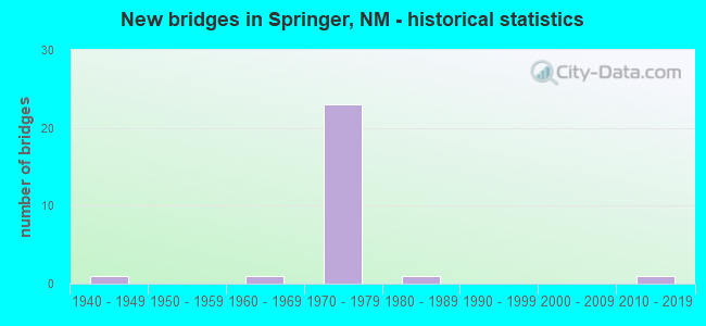
- New bridges - historical statistics
- 11940-1949
- 11960-1969
- 231970-1979
- 11980-1989
- 12010-2019


- Bridge Condition - Deck
- 37.5%Good
- 25.0%Satisfactory
- 25.0%Fair
- 12.5%Poor

- Bridge Condition - Superstructure
- 18.8%Good
- 43.8%Satisfactory
- 25.0%Fair
- 12.5%Poor

- Bridge Condition - Substructure
- 43.8%Good
- 25.0%Satisfactory
- 31.3%Fair

- Bridge Condition - Channel
- 80.0%Good
- 20.0%Satisfactory
Find on map >> Show street view
Structure Number: 7068, Location: 6.6 MI N MORA/COLFAX CL (Lat: 36.308114, Lng: -104.625808), Route carried "on" structure: Interstate 25, Year Built: 1969, Status: Open, Structure Length: 0.70m (2.30ft), Average Daily Traffic: 6,446 (year 2020), Truck Traffic: 37%, Average Future Daily Traffic: 11,035 (year 2040), Design Load: HS 20, Features Intersected: UNNAMED WATERWAY
Minimum Vertical Clearance: 30+ m (98+ ft), Kilometerpoint: 658.383, Lanes on structure: 4, Base Highway Network: Yes, Owner: State Highway Agency, Approaching Roadway Width: 24.4m (80.1ft), Skew: 10 degrees, Material/Design: Concrete continuous, Design/Construction: Culvert, Number Of Spans In Main Unit: 2, Length of Maximum Span: 3.0m (9.8ft)
Condition: Channel: Satisfactory, Culverts: Satisfactory, Operating Rating: 37.3 metric tons, Method Used To Determine Operating Rating: Load Factor (LF), Inventory Rating: 32.4 metric tons, Method Used To Determine Inventory Rating: Load Factor (LF), Structural Evaluation: Equal to present minimum criteria, Waterway Adequacy: Equal to present desirable criteria, Approach Roadway Alignment: Equal to present desirable criteria, Designated Inspection Frequency: Every 48 months, Inspection Date: January 2019
Find on map >> Show street view
Structure Number: 7286, Location: SOUTH SPRINGER INTERCHANG (Lat: 36.351625, Lng: -104.606511), Route carried "on" structure: Interstate 25, Year Built: 1973, Status: Open, Structure Length: 4.57m (14.99ft), Average Daily Traffic: 6,496 (year 2020), Truck Traffic: 37%, Average Future Daily Traffic: 11,121 (year 2040), Design Load: HS 20, Features Intersected: LOOP-16
Minimum Vertical Clearance: 30+ m (98+ ft), Kilometerpoint: 663.487, Lanes on structure: 2, Lanes under structure: 2, Base Highway Network: Yes, Owner: State Highway Agency, Approaching Roadway Width: 12.8m (42.0ft), Skew: 10 degrees, Material/Design: Prestressed concrete, Design/Construction: Stringer/Multi-beam, Number Of Spans In Main Unit: 3, Length of Maximum Span: 16.5m (54.1ft), Curb-To-Curb Width: 12.8m (42.0ft), Out-to-Out Width: 13.7m (44.9ft)
Condition: Deck: Fair, Superstructure: Fair, Substructure: Satisfactory, Operating Rating: 53.9 metric tons, Method Used To Determine Operating Rating: Load Factor (LF), Inventory Rating: 32.7 metric tons, Method Used To Determine Inventory Rating: Load Factor (LF), Structural Evaluation: Somewhat better than minimum adequacy, Deck Geometry: Equal to present desirable criteria, Underclear: Equal to present minimum criteria, Approach Roadway Alignment: Equal to present desirable criteria, Designated Inspection Frequency: Every 24 months, Inspection Date: March 2021, Deck Structure Type: Concrete Cast-file-Place, Wearing Surface/Protective System: Wearing Surface: Epoxy Overlay
Find on map >> Show street view
Structure Number: 7287, Location: SOUTH SPRINGER INTERCHANG (Lat: 36.351731, Lng: -104.606869), Route carried "on" structure: Interstate 25, Year Built: 1973, Status: Open, Structure Length: 4.57m (14.99ft), Average Daily Traffic: 4,922 (year 2020), Truck Traffic: 37%, Average Future Daily Traffic: 8,425 (year 2040), Design Load: HS 20, Features Intersected: LOOP-16
Minimum Vertical Clearance: 30+ m (98+ ft), Kilometerpoint: 663.487, Lanes on structure: 2, Lanes under structure: 2, Base Highway Network: Yes, Owner: State Highway Agency, Approaching Roadway Width: 12.8m (42.0ft), Skew: 10 degrees, Material/Design: Prestressed concrete, Design/Construction: Stringer/Multi-beam, Number Of Spans In Main Unit: 3, Length of Maximum Span: 16.5m (54.1ft), Curb-To-Curb Width: 12.8m (42.0ft), Out-to-Out Width: 13.7m (44.9ft)
Condition: Deck: Good, Superstructure: Fair, Substructure: Good, Operating Rating: 53.9 metric tons, Method Used To Determine Operating Rating: Load Factor (LF), Inventory Rating: 32.7 metric tons, Method Used To Determine Inventory Rating: Load Factor (LF), Structural Evaluation: Somewhat better than minimum adequacy, Deck Geometry: Equal to present desirable criteria, Underclear: High priority of corrective action, Approach Roadway Alignment: Equal to present desirable criteria, Designated Inspection Frequency: Every 24 months, Inspection Date: March 2021, Deck Structure Type: Concrete Cast-file-Place, Wearing Surface/Protective System: Wearing Surface: Epoxy Overlay, Deck Protection: Epoxy Coated Reinforcing
Find on map >> Show street view
Structure Number: 7288, Location: 9.7 MI N COLFAX/MORA CL (Lat: 36.352722, Lng: -104.606017), Route carried "on" structure: Interstate 25, Year Built: 1973, Status: Open, Structure Length: 5.76m (18.90ft), Average Daily Traffic: 6,496 (year 2020), Truck Traffic: 37%, Average Future Daily Traffic: 11,121 (year 2040), Design Load: HS 20, Features Intersected: LITTLE CREEK
Minimum Vertical Clearance: 30+ m (98+ ft), Kilometerpoint: 663.533, Lanes on structure: 2, Base Highway Network: Yes, Owner: State Highway Agency, Approaching Roadway Width: 12.8m (42.0ft), Skew: 11 degrees, Material/Design: Prestressed concrete, Design/Construction: Stringer/Multi-beam, Number Of Spans In Main Unit: 3, Length of Maximum Span: 18.6m (61.0ft), Curb-To-Curb Width: 12.8m (42.0ft), Out-to-Out Width: 13.7m (44.9ft)
Condition: Deck: Fair, Superstructure: Fair, Substructure: Fair, Channel: Good, Operating Rating: 53.9 metric tons, Method Used To Determine Operating Rating: Load Factor (LF), Inventory Rating: 32.7 metric tons, Method Used To Determine Inventory Rating: Load Factor (LF), Structural Evaluation: Somewhat better than minimum adequacy, Deck Geometry: Equal to present desirable criteria, Waterway Adequacy: Equal to present desirable criteria, Approach Roadway Alignment: Equal to present desirable criteria, Designated Inspection Frequency: Every 24 months, Inspection Date: March 2021, Deck Structure Type: Concrete Cast-file-Place
Find on map >> Show street view
Structure Number: 7289, Location: 9.7 MI N COLFAX/MORA CL (Lat: 36.352775, Lng: -104.606403), Route carried "on" structure: Interstate 25, Year Built: 1973, Status: Open, Structure Length: 5.76m (18.90ft), Average Daily Traffic: 6,496 (year 2020), Truck Traffic: 37%, Average Future Daily Traffic: 11,121 (year 2040), Design Load: HS 20, Features Intersected: LITTLE CREEK
Minimum Vertical Clearance: 30+ m (98+ ft), Kilometerpoint: 663.533, Lanes on structure: 2, Base Highway Network: Yes, Owner: State Highway Agency, Approaching Roadway Width: 12.8m (42.0ft), Skew: 11 degrees, Material/Design: Prestressed concrete, Design/Construction: Stringer/Multi-beam, Number Of Spans In Main Unit: 3, Length of Maximum Span: 18.6m (61.0ft), Curb-To-Curb Width: 12.8m (42.0ft), Out-to-Out Width: 13.7m (44.9ft)
Condition: Deck: Satisfactory, Superstructure: Fair, Substructure: Fair, Channel: Good, Operating Rating: 53.9 metric tons, Method Used To Determine Operating Rating: Load Factor (LF), Inventory Rating: 32.7 metric tons, Method Used To Determine Inventory Rating: Load Factor (LF), Structural Evaluation: Somewhat better than minimum adequacy, Deck Geometry: Equal to present desirable criteria, Waterway Adequacy: Equal to present desirable criteria, Approach Roadway Alignment: Equal to present desirable criteria, Designated Inspection Frequency: Every 24 months, Inspection Date: March 2021, Deck Structure Type: Concrete Cast-file-Place
Find on map >> Show street view
Structure Number: 729, Location: 9.7 MI N COLFAX/MORA CL (Lat: 36.352664, Lng: -104.605358), Route carried "on" structure: Ramp Interstate 2412, Year Built: 1973, Status: Open, Structure Length: 4.08m (13.39ft), Average Daily Traffic: 56 (year 2020), Truck Traffic: 38%, Average Future Daily Traffic: 95 (year 2040), Design Load: HS 20, Features Intersected: LITTLE CREEK
Minimum Vertical Clearance: 30+ m (98+ ft), Kilometerpoint: 0.040, Lanes on structure: 1, Base Highway Network: Yes, Owner: State Highway Agency, Approaching Roadway Width: 7.3m (24.0ft), Material/Design: Prestressed concrete, Design/Construction: Stringer/Multi-beam, Number Of Spans In Main Unit: 3, Length of Maximum Span: 13.1m (43.0ft), Curb-To-Curb Width: 7.3m (24.0ft), Out-to-Out Width: 8.2m (26.9ft)
Condition: Deck: Poor, Superstructure: Satisfactory, Substructure: Fair, Channel: Good, Operating Rating: 66.1 metric tons, Method Used To Determine Operating Rating: Load Factor (LF), Inventory Rating: 39.5 metric tons, Method Used To Determine Inventory Rating: Load Factor (LF), Structural Evaluation: Somewhat better than minimum adequacy, Deck Geometry: Better than present minimum criteria, Waterway Adequacy: Equal to present desirable criteria, Approach Roadway Alignment: Equal to present desirable criteria, Designated Inspection Frequency: Every 24 months, Inspection Date: March 2021, Deck Structure Type: Concrete Cast-file-Place
Find on map >> Show street view
Structure Number: 7291, Location: 9.7 MI N COLFAX/MORA CL (Lat: 36.352881, Lng: -104.607233), Route carried "on" structure: Ramp Interstate 2412, Year Built: 1973, Status: Open, Structure Length: 4.57m (14.99ft), Average Daily Traffic: 58 (year 2020), Truck Traffic: 38%, Average Future Daily Traffic: 100 (year 2040), Design Load: HS 20, Features Intersected: LITTLE CREEK
Minimum Vertical Clearance: 30+ m (98+ ft), Kilometerpoint: 0.040, Lanes on structure: 1, Base Highway Network: Yes, Owner: State Highway Agency, Approaching Roadway Width: 7.3m (24.0ft), Skew: 2 degrees, Material/Design: Prestressed concrete, Design/Construction: Stringer/Multi-beam, Number Of Spans In Main Unit: 3, Length of Maximum Span: 14.6m (47.9ft), Curb-To-Curb Width: 7.3m (24.0ft), Out-to-Out Width: 8.2m (26.9ft)
Condition: Deck: Poor, Superstructure: Poor, Substructure: Fair, Channel: Good, Operating Rating: 53.5 metric tons, Method Used To Determine Operating Rating: Load Factor (LF), Inventory Rating: 32.4 metric tons, Method Used To Determine Inventory Rating: Load Factor (LF), Structural Evaluation: Meets minimum limits, Deck Geometry: Better than present minimum criteria, Waterway Adequacy: Equal to present desirable criteria, Approach Roadway Alignment: Equal to present desirable criteria, Designated Inspection Frequency: Every 24 months, Inspection Date: March 2021, Deck Structure Type: Concrete Cast-file-Place
Find on map >> Show street view
Structure Number: 7292, Location: 9.7 MI N MORA/COLFAX CL (Lat: 36.352158, Lng: -104.608417), Route carried "on" structure: State highway 2164, Year Built: 1973, Status: Open, Structure Length: 3.17m (10.40ft), Average Daily Traffic: 143 (year 2020), Truck Traffic: 19%, Average Future Daily Traffic: 207 (year 2040), Design Load: HS 20, Features Intersected: LITTLE CREEK
Minimum Vertical Clearance: 30+ m (98+ ft), Kilometerpoint: 1.287, Lanes on structure: 2, Owner: State Highway Agency, Approaching Roadway Width: 9.8m (32.2ft), Skew: 1 degrees, Material/Design: Concrete continuous, Design/Construction: Slab, Number Of Spans In Main Unit: 3, Length of Maximum Span: 12.2m (40.0ft), Curb-To-Curb Width: 9.8m (32.2ft), Out-to-Out Width: 10.7m (35.1ft)
Condition: Deck: Fair, Superstructure: Satisfactory, Substructure: Satisfactory, Channel: Good, Operating Rating: 57.3 metric tons, Method Used To Determine Operating Rating: Load Factor (LF), Inventory Rating: 34.3 metric tons, Method Used To Determine Inventory Rating: Load Factor (LF), Structural Evaluation: Equal to present minimum criteria, Deck Geometry: Better than present minimum criteria, Waterway Adequacy: Equal to present desirable criteria, Approach Roadway Alignment: Equal to present desirable criteria, Designated Inspection Frequency: Every 24 months, Inspection Date: March 2021, Deck Structure Type: Concrete Cast-file-Place, Wearing Surface/Protective System: Deck Protection: Epoxy Coated Reinforcing
Find on map >> Show street view
Structure Number: 7293, Location: JCT I-25/NM-21 @ SPRINGER (Lat: 36.361136, Lng: -104.603675), Route carried "on" structure: Interstate 25, Year Built: 1973, Status: Open, Structure Length: 4.42m (14.50ft), Average Daily Traffic: 6,496 (year 2020), Truck Traffic: 37%, Average Future Daily Traffic: 11,121 (year 2040), Design Load: HS 20, Features Intersected: NM-21
Minimum Vertical Clearance: 30+ m (98+ ft), Kilometerpoint: 664.582, Lanes on structure: 2, Lanes under structure: 2, Base Highway Network: Yes, Owner: State Highway Agency, Approaching Roadway Width: 12.8m (42.0ft), Skew: 10 degrees, Material/Design: Prestressed concrete, Design/Construction: Stringer/Multi-beam, Number Of Spans In Main Unit: 3, Length of Maximum Span: 14.9m (48.9ft), Curb-To-Curb Width: 12.8m (42.0ft), Out-to-Out Width: 13.7m (44.9ft)
Condition: Deck: Satisfactory, Superstructure: Satisfactory, Substructure: Good, Operating Rating: 53.9 metric tons, Method Used To Determine Operating Rating: Load Factor (LF), Inventory Rating: 32.7 metric tons, Method Used To Determine Inventory Rating: Load Factor (LF), Structural Evaluation: Equal to present minimum criteria, Deck Geometry: Equal to present desirable criteria, Underclear: Better than present minimum criteria, Approach Roadway Alignment: Equal to present desirable criteria, Designated Inspection Frequency: Every 24 months, Inspection Date: March 2021, Deck Structure Type: Concrete Cast-file-Place, Wearing Surface/Protective System: Deck Protection: Epoxy Coated Reinforcing
Find on map >> Show street view
Structure Number: 7294, Location: JCT I-25/NM-21 @ SPRINGER (Lat: 36.361164, Lng: -104.603978), Route carried "on" structure: Interstate 25, Year Built: 1973, Status: Open, Structure Length: 4.42m (14.50ft), Average Daily Traffic: 6,496 (year 2020), Truck Traffic: 37%, Average Future Daily Traffic: 11,121 (year 2040), Design Load: HS 20, Features Intersected: NM-21
Minimum Vertical Clearance: 30+ m (98+ ft), Kilometerpoint: 664.582, Lanes on structure: 2, Lanes under structure: 2, Base Highway Network: Yes, Owner: State Highway Agency, Approaching Roadway Width: 12.8m (42.0ft), Skew: 10 degrees, Material/Design: Prestressed concrete, Design/Construction: Stringer/Multi-beam, Number Of Spans In Main Unit: 3, Length of Maximum Span: 14.9m (48.9ft), Curb-To-Curb Width: 12.8m (42.0ft), Out-to-Out Width: 13.7m (44.9ft)
Condition: Deck: Satisfactory, Superstructure: Satisfactory, Substructure: Good, Operating Rating: 53.9 metric tons, Method Used To Determine Operating Rating: Load Factor (LF), Inventory Rating: 32.7 metric tons, Method Used To Determine Inventory Rating: Load Factor (LF), Structural Evaluation: Equal to present minimum criteria, Deck Geometry: Equal to present desirable criteria, Underclear: Better than present minimum criteria, Approach Roadway Alignment: Equal to present desirable criteria, Designated Inspection Frequency: Every 24 months, Inspection Date: March 2021, Deck Structure Type: Concrete Cast-file-Place, Wearing Surface/Protective System: Deck Protection: Epoxy Coated Reinforcing
Find on map >> Show street view
Structure Number: 7295, Location: 10.7 MI N MORA/COLFAX CL (Lat: 36.366297, Lng: -104.602700), Route carried "on" structure: Interstate 25, Year Built: 1973, Status: Open, Structure Length: 13.32m (43.70ft), Average Daily Traffic: 6,496 (year 2020), Truck Traffic: 37%, Average Future Daily Traffic: 11,121 (year 2040), Design Load: HS 20, Features Intersected: CIMARRON RIVER
Minimum Vertical Clearance: 30+ m (98+ ft), Kilometerpoint: 665.116, Lanes on structure: 2, Base Highway Network: Yes, Owner: State Highway Agency, Approaching Roadway Width: 12.8m (42.0ft), Skew: 13 degrees, Material/Design: Prestressed concrete, Design/Construction: Stringer/Multi-beam, Number Of Spans In Main Unit: 7, Length of Maximum Span: 18.6m (61.0ft), Curb-To-Curb Width: 12.8m (42.0ft), Out-to-Out Width: 13.7m (44.9ft)
Condition: Deck: Good, Superstructure: Good, Substructure: Satisfactory, Channel: Good, Operating Rating: 53.9 metric tons, Method Used To Determine Operating Rating: Load Factor (LF), Inventory Rating: 31.3 metric tons, Method Used To Determine Inventory Rating: Load Factor (LF), Structural Evaluation: Equal to present minimum criteria, Deck Geometry: Equal to present desirable criteria, Waterway Adequacy: Equal to present desirable criteria, Approach Roadway Alignment: Equal to present desirable criteria, Designated Inspection Frequency: Every 24 months, Inspection Date: October 2021, Deck Structure Type: Concrete Cast-file-Place
Find on map >> Show street view
Structure Number: 7296, Location: 10.7 MI N MORA/COLFAX CL (Lat: 36.366400, Lng: -104.603000), Route carried "on" structure: Interstate 25, Year Built: 1973, Status: Open, Structure Length: 13.32m (43.70ft), Average Daily Traffic: 6,496 (year 2020), Truck Traffic: 37%, Average Future Daily Traffic: 11,121 (year 2040), Design Load: HS 20, Features Intersected: CIMARRON RIVER
Minimum Vertical Clearance: 30+ m (98+ ft), Kilometerpoint: 665.116, Lanes on structure: 2, Base Highway Network: Yes, Owner: State Highway Agency, Approaching Roadway Width: 12.8m (42.0ft), Skew: 13 degrees, Material/Design: Prestressed concrete, Design/Construction: Stringer/Multi-beam, Number Of Spans In Main Unit: 7, Length of Maximum Span: 18.6m (61.0ft), Curb-To-Curb Width: 12.8m (42.0ft), Out-to-Out Width: 13.7m (44.9ft)
Condition: Deck: Good, Superstructure: Good, Substructure: Good, Channel: Good, Operating Rating: 53.9 metric tons, Method Used To Determine Operating Rating: Load Factor (LF), Inventory Rating: 31.3 metric tons, Method Used To Determine Inventory Rating: Load Factor (LF), Structural Evaluation: Better than present minimum criteria, Deck Geometry: Equal to present desirable criteria, Waterway Adequacy: Equal to present desirable criteria, Approach Roadway Alignment: Equal to present desirable criteria, Designated Inspection Frequency: Every 24 months, Inspection Date: October 2021, Deck Structure Type: Concrete Cast-file-Place, Wearing Surface/Protective System: Deck Protection: Epoxy Coated Reinforcing
Find on map >> Show street view
Structure Number: 7297, Location: 1.2 MI S SPRINGER N INTER (Lat: 36.370033, Lng: -104.602000), Route carried "on" structure: Interstate 25, Year Built: 1973, Status: Open, Structure Length: 5.64m (18.50ft), Average Daily Traffic: 6,496 (year 2020), Truck Traffic: 37%, Average Future Daily Traffic: 11,121 (year 2040), Design Load: HS 20, Features Intersected: NM-468
Minimum Vertical Clearance: 30+ m (98+ ft), Kilometerpoint: 665.639, Lanes on structure: 2, Lanes under structure: 2, Base Highway Network: Yes, Owner: State Highway Agency, Approaching Roadway Width: 12.8m (42.0ft), Skew: 13 degrees, Material/Design: Prestressed concrete, Design/Construction: Stringer/Multi-beam, Number Of Spans In Main Unit: 3, Length of Maximum Span: 21.3m (69.9ft), Curb-To-Curb Width: 12.8m (42.0ft), Out-to-Out Width: 13.7m (44.9ft)
Condition: Deck: Good, Superstructure: Satisfactory, Substructure: Good, Operating Rating: 53.9 metric tons, Method Used To Determine Operating Rating: Load Factor (LF), Inventory Rating: 32.7 metric tons, Method Used To Determine Inventory Rating: Load Factor (LF), Structural Evaluation: Equal to present minimum criteria, Deck Geometry: Equal to present desirable criteria, Underclear: Better than present minimum criteria, Approach Roadway Alignment: Equal to present desirable criteria, Designated Inspection Frequency: Every 24 months, Inspection Date: March 2021, Deck Structure Type: Concrete Cast-file-Place, Wearing Surface/Protective System: Deck Protection: Epoxy Coated Reinforcing
Find on map >> Show street view
Structure Number: 7298, Location: 1.2 MI S SPRINGER N INTER (Lat: 36.370264, Lng: -104.602253), Route carried "on" structure: Interstate 25, Year Built: 1973, Status: Open, Structure Length: 5.97m (19.59ft), Average Daily Traffic: 6,496 (year 2020), Truck Traffic: 37%, Average Future Daily Traffic: 11,121 (year 2040), Design Load: HS 20, Features Intersected: NM-468
Minimum Vertical Clearance: 30+ m (98+ ft), Kilometerpoint: 665.639, Lanes on structure: 2, Lanes under structure: 2, Base Highway Network: Yes, Owner: State Highway Agency, Approaching Roadway Width: 12.8m (42.0ft), Skew: 14 degrees, Material/Design: Prestressed concrete, Design/Construction: Stringer/Multi-beam, Number Of Spans In Main Unit: 3, Length of Maximum Span: 22.3m (73.2ft), Curb-To-Curb Width: 12.8m (42.0ft), Out-to-Out Width: 13.7m (44.9ft)
Condition: Deck: Good, Superstructure: Satisfactory, Substructure: Good, Operating Rating: 53.9 metric tons, Method Used To Determine Operating Rating: Load Factor (LF), Inventory Rating: 32.7 metric tons, Method Used To Determine Inventory Rating: Load Factor (LF), Structural Evaluation: Equal to present minimum criteria, Deck Geometry: Equal to present desirable criteria, Underclear: Equal to present minimum criteria, Approach Roadway Alignment: Better than present minimum criteria, Designated Inspection Frequency: Every 24 months, Inspection Date: March 2021, Deck Structure Type: Concrete Cast-file-Place, Wearing Surface/Protective System: Deck Protection: Epoxy Coated Reinforcing
Find on map >> Show street view
Structure Number: 7299, Location: NORTH SPRINGER INTERCHANG (Lat: 36.387047, Lng: -104.595653), Route carried "on" structure: State highway 16, Year Built: 1973, Status: Open, Structure Length: 8.38m (27.49ft), Average Daily Traffic: 1,482 (year 2020), Truck Traffic: 20%, Average Future Daily Traffic: 2,151 (year 2040), Design Load: HS 20, Features Intersected: I-25 NBLS/SBLS
Minimum Vertical Clearance: 30+ m (98+ ft), Kilometerpoint: 5.327, Lanes on structure: 2, Lanes under structure: 4, Owner: State Highway Agency, Approaching Roadway Width: 9.8m (32.2ft), Material/Design: Prestressed concrete, Design/Construction: Stringer/Multi-beam, Number Of Spans In Main Unit: 4, Length of Maximum Span: 28.7m (94.2ft), Curb-To-Curb Width: 9.8m (32.2ft), Out-to-Out Width: 10.7m (35.1ft)
Condition: Deck: Fair, Superstructure: Poor, Substructure: Fair, Operating Rating: 53.9 metric tons, Method Used To Determine Operating Rating: Load Factor (LF), Inventory Rating: 32.7 metric tons, Method Used To Determine Inventory Rating: Load Factor (LF), Structural Evaluation: Meets minimum limits, Deck Geometry: Somewhat better than minimum adequacy, Underclear: Somewhat better than minimum adequacy, Approach Roadway Alignment: Meets minimum limits, Designated Inspection Frequency: Every 24 months, Inspection Date: May 2021, Deck Structure Type: Concrete Cast-file-Place, Wearing Surface/Protective System: Wearing Surface: Epoxy Overlay
Find on map >> Show street view
Structure Number: 7419, Location: 3.0 MI S OF JCT NM-58 (Lat: 36.405392, Lng: -104.595167), Route carried "on" structure: Interstate 25, Year Built: 1973, Status: Open, Structure Length: 0.85m (2.79ft), Average Daily Traffic: 7,116 (year 2020), Truck Traffic: 37%, Average Future Daily Traffic: 12,182 (year 2040), Design Load: HS 20+Mod, Features Intersected: COUNTY ROAD 32
Minimum Vertical Clearance: 30+ m (98+ ft), Kilometerpoint: 669.616, Lanes on structure: 4, Lanes under structure: 2, Base Highway Network: Yes, Owner: State Highway Agency, Approaching Roadway Width: 26.8m (87.9ft), Skew: 10 degrees, Material/Design: Concrete, Design/Construction: Culvert, Number Of Spans In Main Unit: 1, Length of Maximum Span: 7.6m (24.9ft)
Condition: Culverts: Satisfactory, Operating Rating: 55.1 metric tons, Method Used To Determine Operating Rating: Load Factor (LF), Inventory Rating: 35.6 metric tons, Method Used To Determine Inventory Rating: Load Factor (LF), Structural Evaluation: Equal to present minimum criteria, Underclear: High priority of corrective action, Approach Roadway Alignment: Equal to present desirable criteria, Length Of Structure Improvement: 0.85m (2.79ft), Designated Inspection Frequency: Every 24 months, Inspection Date: June 2020, Bridge Improvement Cost: $270,000, Roadway Improvement Cost: $27,000, Total Project Cost: $405,000 ( Estimate for 2020)
Find on map >> Show street view
Structure Number: 8579, Location: .2 MI W MAXWELL AVE/SPRIN (Lat: 36.361042, Lng: -104.598836), Route carried "on" structure: State highway 21, Year Built: 1986, Status: Open, Structure Length: 4.82m (15.81ft), Average Daily Traffic: 391 (year 2020), Truck Traffic: 15%, Average Future Daily Traffic: 731 (year 2040), Design Load: HS 20+Mod, Features Intersected: CIMARRON RIVER
Minimum Vertical Clearance: 30+ m (98+ ft), Kilometerpoint: 54.702, Lanes on structure: 2, Owner: State Highway Agency, Approaching Roadway Width: 9.1m (29.9ft), Skew: 1 degrees, Material/Design: Prestressed concrete continuous, Design/Construction: Stringer/Multi-beam, Number Of Spans In Main Unit: 3, Length of Maximum Span: 17.4m (57.1ft), Curb or Sidewalk Widths: Left: 1.5m (4.9ft), Right: 0.0m, Curb-To-Curb Width: 9.1m (29.9ft), Out-to-Out Width: 11.6m (38.1ft)
Condition: Deck: Satisfactory, Superstructure: Satisfactory, Substructure: Satisfactory, Channel: Good, Operating Rating: 53.5 metric tons, Method Used To Determine Operating Rating: Load Factor (LF), Inventory Rating: 32.4 metric tons, Method Used To Determine Inventory Rating: Load Factor (LF), Structural Evaluation: Equal to present minimum criteria, Deck Geometry: Equal to present minimum criteria, Waterway Adequacy: Equal to present desirable criteria, Approach Roadway Alignment: Equal to present desirable criteria, Designated Inspection Frequency: Every 24 months, Inspection Date: June 2021, Deck Structure Type: Concrete Cast-file-Place, Wearing Surface/Protective System: Deck Protection: Epoxy Coated Reinforcing
Find on map >> Show street view
Structure Number: 9612, Location: 0.6 M N OF I-25/S SPRINGR (Lat: 36.355422, Lng: -104.596878), Route carried "on" structure: State highway 16, Year Built: 2014, Status: Open, Structure Length: 9.53m (31.27ft), Average Daily Traffic: 551 (year 2020), Truck Traffic: 20%, Average Future Daily Traffic: 800 (year 2040), Design Load: HS 20, Features Intersected: CIMARRON RIVER
Minimum Vertical Clearance: 30+ m (98+ ft), Kilometerpoint: 1.347, Lanes on structure: 2, Owner: State Highway Agency, Approaching Roadway Width: 7.9m (25.9ft), Skew: 1 degrees, Material/Design: Prestressed concrete continuous, Design/Construction: Stringer/Multi-beam, Number Of Spans In Main Unit: 5, Length of Maximum Span: 19.2m (63.0ft), Curb or Sidewalk Widths: Left: 0.5m (1.6ft), Right: 0.5m (1.6ft), Curb-To-Curb Width: 8.6m (28.2ft), Out-to-Out Width: 9.8m (32.2ft)
Condition: Deck: Good, Superstructure: Good, Substructure: Good, Channel: Satisfactory, Operating Rating: 64.3 metric tons, Method Used To Determine Operating Rating: Load Factor (LF), Inventory Rating: 37.1 metric tons, Method Used To Determine Inventory Rating: Load Factor (LF), Structural Evaluation: Better than present minimum criteria, Deck Geometry: Somewhat better than minimum adequacy, Waterway Adequacy: Equal to present desirable criteria, Approach Roadway Alignment: Better than present minimum criteria, Designated Inspection Frequency: Every 24 months, Inspection Date: January 2021, Deck Structure Type: Concrete Cast-file-Place, Wearing Surface/Protective System: Wearing Surface: Bituminous
Find on map >> Show street view
Structure Number: 264, Location: 0.1 MI E OF JCT LOOP-16 (Lat: 36.361033, Lng: -104.593103), Route carried "under" structure: US 56, Year Built: 1940, Structure Length: 0. m, Average Daily Traffic: 2,110 (year 2020), Truck Traffic: 20%, Features Intersected: US-56, Facility Carried by Structure: RAILROAD
Minimum Vertical Clearance: 4.52m (14.83ft), Kilometerpoint: 0.209, Lanes under structure: 2, Material/Design: Steel, Design/Construction: Stringer/Multi-beam, Length of Maximum Span: 11.3m (37.1ft)
Find on map >> Show street view
Structure Number: 7286, Location: SOUTH SPRINGER INTERCHANG (Lat: 36.351625, Lng: -104.606511), Route carried "under" structure: State highway 16, Year Built: 1973, Structure Length: 0. m, Average Daily Traffic: 333 (year 2020), Truck Traffic: 20%, Features Intersected: LOOP-16, Facility Carried by Structure: I-25 NBL
Minimum Vertical Clearance: 4.69m (15.39ft), Kilometerpoint: 1.429, Lanes on structure: 2, Lanes under structure: 2, Material/Design: Prestressed concrete, Design/Construction: Stringer/Multi-beam, Length of Maximum Span: 16.5m (54.1ft)
Find on map >> Show street view
Structure Number: 7287, Location: SOUTH SPRINGER INTERCHANG (Lat: 36.351731, Lng: -104.606869), Route carried "under" structure: State highway 16, Year Built: 1973, Structure Length: 0. m, Average Daily Traffic: 333 (year 2020), Truck Traffic: 20%, Features Intersected: LOOP-16, Facility Carried by Structure: I-25 SBL
Minimum Vertical Clearance: 5.05m (16.57ft), Kilometerpoint: 1.394, Lanes on structure: 2, Lanes under structure: 2, Material/Design: Prestressed concrete, Design/Construction: Stringer/Multi-beam, Length of Maximum Span: 16.5m (54.1ft)
Find on map >> Show street view
Structure Number: 7293, Location: JCT I-25/NM-21 @ SPRINGER (Lat: 36.361136, Lng: -104.603675), Route carried "under" structure: State highway 21, Year Built: 1973, Structure Length: 0. m, Average Daily Traffic: 391 (year 2020), Truck Traffic: 15%, Features Intersected: NM-21, Facility Carried by Structure: I-25 NBL
Minimum Vertical Clearance: 5.72m (18.77ft), Kilometerpoint: 54.454, Lanes on structure: 2, Lanes under structure: 2, Material/Design: Prestressed concrete, Design/Construction: Stringer/Multi-beam, Length of Maximum Span: 14.9m (48.9ft)
Find on map >> Show street view
Structure Number: 7294, Location: JCT I-25/NM-21 @ SPRINGER (Lat: 36.361164, Lng: -104.603978), Route carried "under" structure: State highway 21, Year Built: 1973, Structure Length: 0. m, Average Daily Traffic: 391 (year 2020), Truck Traffic: 15%, Features Intersected: NM-21, Facility Carried by Structure: I-25 SBL
Minimum Vertical Clearance: 4.90m (16.08ft), Kilometerpoint: 54.425, Lanes on structure: 2, Lanes under structure: 2, Material/Design: Prestressed concrete, Design/Construction: Stringer/Multi-beam, Length of Maximum Span: 14.9m (48.9ft)
Find on map >> Show street view
Structure Number: 7297, Location: 1.2 MI S SPRINGER N INTER (Lat: 36.370033, Lng: -104.602000), Route carried "under" structure: State highway 468, Year Built: 1973, Structure Length: 0. m, Average Daily Traffic: 287 (year 2020), Truck Traffic: 15%, Features Intersected: NM-468, Facility Carried by Structure: I-25 NBL
Minimum Vertical Clearance: 5.00m (16.40ft), Kilometerpoint: 0.352, Lanes on structure: 2, Lanes under structure: 2, Material/Design: Prestressed concrete, Design/Construction: Stringer/Multi-beam, Length of Maximum Span: 21.3m (69.9ft)
Find on map >> Show street view
Structure Number: 7298, Location: 1.2 MI S SPRINGER N INTER (Lat: 36.370264, Lng: -104.602253), Route carried "under" structure: State highway 468, Year Built: 1973, Structure Length: 0. m, Average Daily Traffic: 287 (year 2020), Truck Traffic: 15%, Features Intersected: NM-468, Facility Carried by Structure: I-25 SBL
Minimum Vertical Clearance: 5.21m (17.09ft), Kilometerpoint: 0.352, Lanes on structure: 2, Lanes under structure: 2, Material/Design: Prestressed concrete, Design/Construction: Stringer/Multi-beam, Length of Maximum Span: 22.3m (73.2ft)
Find on map >> Show street view
Structure Number: 7299, Location: NORTH SPRINGER INTERCHANG (Lat: 36.387047, Lng: -104.595653), Route carried "under" structure: Interstate 25, Year Built: 1973, Structure Length: 0. m, Average Daily Traffic: 7,116 (year 2020), Truck Traffic: 37%, Features Intersected: I-25 NBLS/SBLS, Facility Carried by Structure: L-00016
Minimum Vertical Clearance: 4.75m (15.58ft), Kilometerpoint: 667.590, Lanes on structure: 2, Lanes under structure: 2, Material/Design: Prestressed concrete, Design/Construction: Stringer/Multi-beam, Length of Maximum Span: 28.7m (94.2ft)
Find on map >> Show street view
Structure Number: 7419, Location: 3.0 MI S OF JCT NM-58 (Lat: 36.405392, Lng: -104.595167), Route carried "under" structure: City street 7000, Year Built: 1973, Structure Length: 0. m, Average Daily Traffic: 1,032 (year 2020), Truck Traffic: 16%, Features Intersected: COUNTY ROAD 32, Facility Carried by Structure: I-25 NBL/SBL
Minimum Vertical Clearance: 4.19m (13.75ft), Kilometerpoint: 0.026, Lanes on structure: 4, Lanes under structure: 2, Material/Design: Concrete, Design/Construction: Culvert, Length of Maximum Span: 7.6m (24.9ft)