Bridge Statistics for St. Charles, Michigan (MI)
Condition, Traffic, Stress, Structural Evaluation, Project Costs
- National Bridge Inventory (NBI) Statistics
- 21Number of bridges
- 161ft / 49.5mTotal length
- $605,000Total costs
- 55,974Total average daily traffic
- 2,389Total average daily truck traffic
- 69,499Total future (year 2008) average daily traffic
- National Bridge Inventory (NBI) Registered Bridges for St. Charles
- No street view available for this location
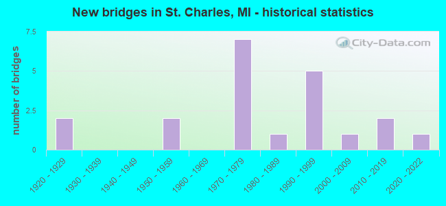
- New bridges - historical statistics
- 21920-1929
- 21950-1959
- 71970-1979
- 11980-1989
- 51990-1999
- 12000-2009
- 22010-2019
- 12020-2022


- Bridge Condition - Deck
- 5.9%Excellent
- 5.9%Very good
- 17.6%Good
- 35.3%Satisfactory
- 29.4%Fair
- 5.9%Serious

- Bridge Condition - Superstructure
- 5.9%Excellent
- 17.6%Very good
- 23.5%Good
- 5.9%Satisfactory
- 23.5%Fair
- 17.6%Poor
- 5.9%Serious

- Bridge Condition - Substructure
- 5.9%Excellent
- 17.6%Very good
- 11.8%Good
- 11.8%Satisfactory
- 29.4%Fair
- 23.5%Poor

- Bridge Condition - Channel
- 9.5%Very good
- 28.6%Good
- 28.6%Satisfactory
- 19.0%Fair
- 14.3%Poor

- Bridge Condition - Culverts
- 25.0%Good
- 75.0%Satisfactory
Find on map >> Show street view
Structure Number: 9062, Location: IN ST CHARLES (Lat: 43.298139, Lng: -84.141972), Route carried "on" structure: State highway 52, Year Built: 1977, Status: Open, Structure Length: 2.74m (8.99ft), Average Daily Traffic: 10,976 (year 2007), Truck Traffic: 6%, Average Future Daily Traffic: 14,100 (year 2026), Design Load: HS 20, Features Intersected: S BR BAD RIVER
Minimum Vertical Clearance: 30.48m (100.00ft), Kilometerpoint: 0.578, Lanes on structure: 4, Base Highway Network: Yes (Inventory Route: 373, Subroute: 10), Owner: State Highway Agency, Approaching Roadway Width: 17.1m (56.1ft), Material/Design: Steel, Design/Construction: Stringer/Multi-beam, Number Of Spans In Main Unit: 1, Length of Maximum Span: 27.4m (89.9ft), Curb or Sidewalk Widths: Left: 1.8m (5.9ft), Right: 1.8m (5.9ft), Curb-To-Curb Width: 15.8m (51.8ft), Out-to-Out Width: 20.2m (66.3ft)
Condition: Deck: Fair, Superstructure: Satisfactory, Substructure: Fair, Channel: Good, Operating Rating: 64.5 metric tons, Method Used To Determine Operating Rating: Load Factor (LF) rating reported by rating factor (RF) method using MS18 loading, Inventory Rating: 38.6 metric tons, Method Used To Determine Inventory Rating: Load Factor (LF) rating reported by rating factor (RF) method using MS18 loading, Structural Evaluation: Somewhat better than minimum adequacy, Deck Geometry: Meets minimum limits, Waterway Adequacy: Equal to present desirable criteria, Approach Roadway Alignment: Equal to present desirable criteria, Designated Inspection Frequency: Every 24 months, Inspection Date: July 2020, Deck Structure Type: Concrete Cast-file-Place, Wearing Surface/Protective System: Wearing Surface: Latex Concrete
Find on map >> Show street view
Structure Number: 9063, Location: IN ST CHARLES (Lat: 43.301986, Lng: -84.143886), Route carried "on" structure: State highway 52, Year Built: 1929, Year Reconstructed: 1999, Status: Open, Structure Length: 3.04m (9.97ft), Average Daily Traffic: 10,976 (year 2007), Truck Traffic: 3%, Average Future Daily Traffic: 14,089 (year 2018), Design Load: H 15, Features Intersected: N BR BAD RIVER
Minimum Vertical Clearance: 30.48m (100.00ft), Kilometerpoint: 1.041, Lanes on structure: 2, Base Highway Network: Yes (Inventory Route: 373, Subroute: 10), Owner: State Highway Agency, Approaching Roadway Width: 14.0m (45.9ft), Material/Design: Prestressed concrete, Design/Construction: Stringer/Multi-beam, Number Of Spans In Main Unit: 2, Length of Maximum Span: 15.2m (49.9ft), Curb or Sidewalk Widths: Left: 1.8m (5.9ft), Right: 1.8m (5.9ft), Curb-To-Curb Width: 12.2m (40.0ft), Out-to-Out Width: 16.8m (55.1ft)
Condition: Deck: Satisfactory, Superstructure: Good, Substructure: Satisfactory, Channel: Satisfactory, Operating Rating: 74.5 metric tons, Method Used To Determine Operating Rating: Load Factor (LF) rating reported by rating factor (RF) method using MS18 loading, Inventory Rating: 40.8 metric tons, Method Used To Determine Inventory Rating: Load Factor (LF) rating reported by rating factor (RF) method using MS18 loading, Structural Evaluation: Equal to present minimum criteria, Deck Geometry: Somewhat better than minimum adequacy, Waterway Adequacy: Equal to present minimum criteria, Approach Roadway Alignment: Equal to present minimum criteria, Designated Inspection Frequency: Every 24 months, Inspection Date: July 2021, Deck Structure Type: Concrete Cast-file-Place, Wearing Surface/Protective System: Wearing Surface: Integral Concrete
Find on map >> Show street view
Structure Number: 9064, Location: N LIMITS OF ST CHARLES (Lat: 43.310708, Lng: -84.142139), Route carried "on" structure: State highway 52, Year Built: 1977, Status: Open, Structure Length: 2.74m (8.99ft), Average Daily Traffic: 10,976 (year 2007), Truck Traffic: 3%, Average Future Daily Traffic: 14,089 (year 2018), Design Load: HS 20, Features Intersected: BEAVER CREEK
Minimum Vertical Clearance: 30.48m (100.00ft), Kilometerpoint: 2.002, Lanes on structure: 2, Base Highway Network: Yes (Inventory Route: 373, Subroute: 10), Owner: State Highway Agency, Approaching Roadway Width: 11.0m (36.1ft), Material/Design: Steel, Design/Construction: Stringer/Multi-beam, Number Of Spans In Main Unit: 1, Length of Maximum Span: 27.4m (89.9ft), Curb-To-Curb Width: 14.6m (47.9ft), Out-to-Out Width: 15.1m (49.5ft)
Condition: Deck: Satisfactory, Superstructure: Good, Substructure: Fair, Channel: Good, Operating Rating: 75.5 metric tons, Method Used To Determine Operating Rating: Load Factor (LF) rating reported by rating factor (RF) method using MS18 loading, Inventory Rating: 45.4 metric tons, Method Used To Determine Inventory Rating: Load Factor (LF) rating reported by rating factor (RF) method using MS18 loading, Structural Evaluation: Somewhat better than minimum adequacy, Deck Geometry: Superior to present desirable criteria, Waterway Adequacy: Equal to present desirable criteria, Approach Roadway Alignment: Equal to present minimum criteria, Designated Inspection Frequency: Every 24 months, Inspection Date: July 2021, Deck Structure Type: Concrete Cast-file-Place, Wearing Surface/Protective System: Wearing Surface: Latex Concrete
Find on map >> Show street view
Structure Number: 9065, Location: 4.0 MI N OF ST CHARLES (Lat: 43.352044, Lng: -84.141139), Route carried "on" structure: State highway 52, Year Built: 2021, Status: Open, Structure Length: 3.90m (12.80ft), Average Daily Traffic: 9,375 (year 2021), Truck Traffic: 4%, Average Future Daily Traffic: 10,350 (year 2041), Design Load: Greater than HL93, Features Intersected: MARSH CREEK
Minimum Vertical Clearance: 30.48m (100.00ft), Kilometerpoint: 6.594, Lanes on structure: 2, Base Highway Network: Yes (Inventory Route: 373, Subroute: 10), Owner: State Highway Agency, Approaching Roadway Width: 13.6m (44.6ft), Material/Design: Prestressed concrete, Design/Construction: Stringer/Multi-beam, Number Of Spans In Main Unit: 1, Length of Maximum Span: 37.9m (124.3ft), Curb-To-Curb Width: 13.8m (45.3ft), Out-to-Out Width: 14.5m (47.6ft)
Condition: Deck: Excellent, Superstructure: Excellent, Substructure: Excellent, Channel: Satisfactory, Operating Rating: 60.9 metric tons, Method Used To Determine Operating Rating: Load and Resistance Factor Rating (LRFR) rating reported by rating factor(RF) method using HL-93 loadings, Inventory Rating: 33.0 metric tons, Method Used To Determine Inventory Rating: Load and Resistance Factor Rating (LRFR) rating reported by rating factor(RF) method using HL-93 loadings, Structural Evaluation: Superior to present desirable criteria, Deck Geometry: Superior to present desirable criteria, Waterway Adequacy: Equal to present desirable criteria, Approach Roadway Alignment: Equal to present desirable criteria, Designated Inspection Frequency: Every 24 months, Inspection Date: March 2022, Deck Structure Type: Concrete Cast-file-Place, Wearing Surface/Protective System: Wearing Surface: Monolithic Concrete, Deck Protection: Other Coated Reinforcing
Find on map >> Show street view
Structure Number: 9208, Location: 1.0 MI E OF HEMLOCK ROAD (Lat: 43.259186, Lng: -84.208478), Route carried "on" structure: County highway 7328, Year Built: 2008, Status: Open, Structure Length: 4.15m (13.62ft), Average Daily Traffic: 1,019 (year 2007), Truck Traffic: 5%, Average Future Daily Traffic: 1,243 (year 2027), Design Load: HS 20, Features Intersected: SOUTH BRANCH BAD RIVER, Facility Carried by Structure: BRANT ROAD
Minimum Vertical Clearance: 30.48m (100.00ft), Kilometerpoint: 13.026, Lanes on structure: 2, Owner: County Highway Agency, Approaching Roadway Width: 9.8m (32.2ft), Material/Design: Prestressed concrete, Design/Construction: Stringer/Multi-beam, Number Of Spans In Main Unit: 2, Length of Maximum Span: 28.3m (92.8ft), Curb-To-Curb Width: 9.8m (32.2ft), Out-to-Out Width: 10.5m (34.4ft)
Condition: Deck: Good, Superstructure: Very good, Substructure: Very good, Channel: Very good, Operating Rating: 75.4 metric tons, Method Used To Determine Operating Rating: Load Factor (LF), Inventory Rating: 45.2 metric tons, Method Used To Determine Inventory Rating: Load Factor (LF), Structural Evaluation: Equal to present desirable criteria, Deck Geometry: Somewhat better than minimum adequacy, Waterway Adequacy: Equal to present minimum criteria, Approach Roadway Alignment: Equal to present desirable criteria, Designated Inspection Frequency: Every 24 months, Inspection Date: October 2020, Deck Structure Type: Concrete Cast-file-Place, Wearing Surface/Protective System: Wearing Surface: Integral Concrete, Deck Protection: Epoxy Coated Reinforcing
Find on map >> Show street view
Structure Number: 9209, Location: 0.2 MI E OF SHARON ROAD (Lat: 43.255008, Lng: -84.104594), Route carried "on" structure: County highway 7326, Year Built: 2013, Status: Open, Structure Length: 7.01m (23.00ft), Average Daily Traffic: 2,353 (year 2013), Truck Traffic: 5%, Average Future Daily Traffic: 4,250 (year 2033), Design Load: Greater than HL93, Features Intersected: SHIAWASSEE RIVER, Facility Carried by Structure: FERGUS RD
Minimum Vertical Clearance: 30.48m (100.00ft), Kilometerpoint: 5.290, Lanes on structure: 2, Owner: County Highway Agency, Approaching Roadway Width: 11.0m (36.1ft), Skew: 4 degrees, Material/Design: Prestressed concrete, Design/Construction: Stringer/Multi-beam, Number Of Spans In Main Unit: 3, Length of Maximum Span: 34.4m (112.9ft), Curb-To-Curb Width: 11.1m (36.4ft), Out-to-Out Width: 11.8m (38.7ft)
Condition: Deck: Good, Superstructure: Very good, Substructure: Very good, Channel: Good, Operating Rating: 71.9 metric tons, Method Used To Determine Operating Rating: Load and Resistance Factor Rating (LRFR) rating reported by rating factor(RF) method using HL-93 loadings, Inventory Rating: 55.4 metric tons, Method Used To Determine Inventory Rating: Load and Resistance Factor Rating (LRFR) rating reported by rating factor(RF) method using HL-93 loadings, Structural Evaluation: Equal to present desirable criteria, Deck Geometry: Somewhat better than minimum adequacy, Waterway Adequacy: Better than present minimum criteria, Approach Roadway Alignment: Equal to present desirable criteria, Designated Inspection Frequency: Every 24 months, Inspection Date: May 2021, Deck Structure Type: Concrete Cast-file-Place, Wearing Surface/Protective System: Wearing Surface: Monolithic Concrete, Deck Protection: Epoxy Coated Reinforcing
Find on map >> Show street view
Structure Number: 921, Location: 0.1 MI E OF STUART ROAD (Lat: 43.255333, Lng: -84.086761), Route carried "on" structure: County highway 7326, Year Built: 1992, Status: Open, Structure Length: 0.79m (2.59ft), Average Daily Traffic: 2,241 (year 2006), Truck Traffic: 10%, Average Future Daily Traffic: 2,353 (year 2016), Design Load: HS 20, Features Intersected: BEAR CREEK, Facility Carried by Structure: FERGUS RD
Minimum Vertical Clearance: 30.48m (100.00ft), Kilometerpoint: 6.737, Lanes on structure: 2, Owner: County Highway Agency, Approaching Roadway Width: 10.1m (33.1ft), Skew: 2 degrees, Material/Design: Concrete, Design/Construction: Culvert, Number Of Spans In Main Unit: 1, Length of Maximum Span: 6.7m (22.0ft), Curb-To-Curb Width: 9.8m (32.2ft), Out-to-Out Width: 11.7m (38.4ft)
Condition: Channel: Satisfactory, Culverts: Satisfactory, Operating Rating: 55.0 metric tons, Method Used To Determine Operating Rating: Field evaluation and documented engineering judgment, Inventory Rating: 33.0 metric tons, Method Used To Determine Inventory Rating: Field evaluation and documented engineering judgment, Structural Evaluation: Equal to present minimum criteria, Deck Geometry: Meets minimum limits, Waterway Adequacy: Equal to present desirable criteria, Approach Roadway Alignment: Equal to present desirable criteria, Designated Inspection Frequency: Every 24 months, Inspection Date: October 2020, Deck Structure Type: Concrete Cast-file-Place, Wearing Surface/Protective System: Wearing Surface: Monolithic Concrete, Deck Protection: Epoxy Coated Reinforcing
Find on map >> Show street view
Structure Number: 924, Location: 0.1 MI N OF COLVIN ROAD (Lat: 43.296939, Lng: -84.229369), Route carried "on" structure: County highway 7323, Year Built: 1998, Status: Open, Structure Length: 3.66m (12.01ft), Average Daily Traffic: 1,831 (year 2006), Truck Traffic: 5%, Average Future Daily Traffic: 1,923 (year 2016), Design Load: HS 20, Features Intersected: NORTH BRANCH BAD RIVER, Facility Carried by Structure: HEMLOCK ROAD
Minimum Vertical Clearance: 30.48m (100.00ft), Kilometerpoint: 9.074, Lanes on structure: 2, Owner: County Highway Agency, Approaching Roadway Width: 7.3m (24.0ft), Material/Design: Prestressed concrete, Design/Construction: Box Beam or Girders - Multiple, Number Of Spans In Main Unit: 2, Length of Maximum Span: 21.3m (69.9ft), Curb-To-Curb Width: 10.7m (35.1ft), Out-to-Out Width: 11.4m (37.4ft)
Condition: Deck: Satisfactory, Superstructure: Good, Substructure: Good, Channel: Good, Operating Rating: 88.1 metric tons, Method Used To Determine Operating Rating: Load Factor (LF) rating reported by rating factor (RF) method using MS18 loading, Inventory Rating: 52.8 metric tons, Method Used To Determine Inventory Rating: Load Factor (LF) rating reported by rating factor (RF) method using MS18 loading, Structural Evaluation: Better than present minimum criteria, Deck Geometry: Equal to present minimum criteria, Waterway Adequacy: Equal to present desirable criteria, Approach Roadway Alignment: Equal to present desirable criteria, Designated Inspection Frequency: Every 24 months, Inspection Date: August 2020, Deck Structure Type: Concrete Precast Panels, Wearing Surface/Protective System: Wearing Surface: Monolithic Concrete, Deck Protection: Epoxy Coated Reinforcing
Find on map >> Show street view
Structure Number: 9244, Location: 0.1 MI N OF BEAVER ROAD (Lat: 43.322481, Lng: -84.189492), Route carried "on" structure: County highway , Year Built: 1954, Status: Posted for load, Structure Length: 3.65m (11.98ft), Average Daily Traffic: 1,102 (year 2015), Truck Traffic: 5%, Average Future Daily Traffic: 1,200 (year 2025), Design Load: H 15, Features Intersected: BEAVER CREEK, Facility Carried by Structure: FORDNEY ROAD
Minimum Vertical Clearance: 30.48m (100.00ft), Kilometerpoint: 1.859, Lanes on structure: 2, Owner: County Highway Agency, Approaching Roadway Width: 10.4m (34.1ft), Material/Design: Steel continuous, Design/Construction: Stringer/Multi-beam, Number Of Spans In Main Unit: 3, Length of Maximum Span: 14.0m (45.9ft), Curb-To-Curb Width: 7.3m (24.0ft), Out-to-Out Width: 9.0m (29.5ft)
Condition: Deck: Satisfactory, Superstructure: Poor, Substructure: Poor, Channel: Fair, Operating Rating: 41.8 metric tons, Method Used To Determine Operating Rating: Load Factor (LF) rating reported by rating factor (RF) method using MS18 loading, Inventory Rating: 24.9 metric tons, Method Used To Determine Inventory Rating: Load Factor (LF) rating reported by rating factor (RF) method using MS18 loading, Structural Evaluation: Meets minimum limits, Deck Geometry: Meets minimum limits, Waterway Adequacy: Equal to present minimum criteria, Approach Roadway Alignment: Equal to present desirable criteria, Bridge Posting: Required (Relationship of Operating Rating to Maximum Legal Load: 20.0 - 29.9% below), Length Of Structure Improvement: 3.66m (12.01ft), Designated Inspection Frequency: Every 12 months, Inspection Date: September 2021, Bridge Improvement Cost: $250,000, Roadway Improvement Cost: $25,000, Total Project Cost: $275,000, Deck Structure Type: Concrete Cast-file-Place, Wearing Surface/Protective System: Wearing Surface: Monolithic Concrete
Find on map >> Show street view
Structure Number: 9324, Location: 0.1 MI N OF BRANT ROAD (Lat: 43.261392, Lng: -84.209067), Route carried "on" structure: ServiceCounty highway , Year Built: 1959, Status: Open, Structure Length: 0.70m (2.30ft), Average Daily Traffic: 267 (year 2006), Average Future Daily Traffic: 280 (year 2016), Design Load: H 15, Features Intersected: BIG POTATO CREEK, Facility Carried by Structure: RAUCHOLZ ROAD
Minimum Vertical Clearance: 30.48m (100.00ft), Kilometerpoint: 0.280, Lanes on structure: 2, Owner: County Highway Agency, Approaching Roadway Width: 7.3m (24.0ft), Material/Design: Steel, Design/Construction: Stringer/Multi-beam, Number Of Spans In Main Unit: 1, Length of Maximum Span: 6.4m (21.0ft), Curb-To-Curb Width: 5.8m (19.0ft), Out-to-Out Width: 6.1m (20.0ft)
Condition: Deck: Satisfactory, Superstructure: Poor, Substructure: Poor, Channel: Satisfactory, Operating Rating: 80.4 metric tons, Method Used To Determine Operating Rating: Load Factor (LF) rating reported by rating factor (RF) method using MS18 loading, Inventory Rating: 48.3 metric tons, Method Used To Determine Inventory Rating: Load Factor (LF) rating reported by rating factor (RF) method using MS18 loading, Structural Evaluation: Meets minimum limits, Deck Geometry: High priority of corrective action, Waterway Adequacy: Equal to present desirable criteria, Approach Roadway Alignment: Meets minimum limits, Length Of Structure Improvement: 0.70m (2.30ft), Designated Inspection Frequency: Every 12 months, Inspection Date: October 2021, Bridge Improvement Cost: $10,000, Deck Structure Type: Corrugated Steel, Wearing Surface/Protective System: Wearing Surface: Gravel
Find on map >> Show street view
Structure Number: 9325, Location: 0.3 MI N OF ITHACA ROAD (Lat: 43.292592, Lng: -84.209144), Route carried "on" structure: ServiceCounty highway , Year Built: 1974, Status: Posted for load, Structure Length: 2.37m (7.78ft), Average Daily Traffic: 206 (year 2006), Truck Traffic: 5%, Average Future Daily Traffic: 216 (year 2016), Design Load: H 15, Features Intersected: NORTH BRANCH BAD RIVER, Facility Carried by Structure: S RAUCHOLZ ROAD
Minimum Vertical Clearance: 30.48m (100.00ft), Kilometerpoint: 3.769, Lanes on structure: 2, Owner: County Highway Agency, Approaching Roadway Width: 9.0m (29.5ft), Material/Design: Wood or Timber, Design/Construction: Slab, Number Of Spans In Main Unit: 3, Length of Maximum Span: 7.9m (25.9ft), Curb-To-Curb Width: 8.0m (26.2ft), Out-to-Out Width: 8.2m (26.9ft)
Condition: Deck: Fair, Superstructure: Fair, Substructure: Fair, Channel: Poor, Operating Rating: 36.0 metric tons, Method Used To Determine Operating Rating: Allowable Stress (AS), Inventory Rating: 26.0 metric tons, Method Used To Determine Inventory Rating: Allowable Stress (AS), Structural Evaluation: Somewhat better than minimum adequacy, Deck Geometry: Somewhat better than minimum adequacy, Waterway Adequacy: Equal to present desirable criteria, Approach Roadway Alignment: Equal to present desirable criteria, Bridge Posting: Required (Relationship of Operating Rating to Maximum Legal Load: > 39.9% below), Designated Inspection Frequency: Every 12 months, Inspection Date: October 2021, Deck Structure Type: Wood or Timber, Wearing Surface/Protective System: Wearing Surface: Bituminous, Deck Protection: Other
Find on map >> Show street view
Structure Number: 9326, Location: 0.2 MI N OF DEMPSEY ROAD (Lat: 43.298914, Lng: -84.189089), Route carried "on" structure: ServiceCounty highway , Year Built: 1985, Status: Open, Structure Length: 3.35m (10.99ft), Average Daily Traffic: 520 (year 2006), Truck Traffic: 5%, Average Future Daily Traffic: 546 (year 2016), Design Load: HS 20+Mod, Features Intersected: N BRANCH BAD RIVER, Facility Carried by Structure: S FORDNEY ROAD
Minimum Vertical Clearance: 30.48m (100.00ft), Kilometerpoint: 2.845, Lanes on structure: 2, Owner: County Highway Agency, Approaching Roadway Width: 9.0m (29.5ft), Material/Design: Prestressed concrete, Design/Construction: Box Beam or Girders - Multiple, Number Of Spans In Main Unit: 2, Length of Maximum Span: 16.7m (54.8ft), Curb-To-Curb Width: 9.0m (29.5ft), Out-to-Out Width: 10.4m (34.1ft)
Condition: Deck: Satisfactory, Superstructure: Fair, Substructure: Good, Channel: Good, Operating Rating: 81.8 metric tons, Method Used To Determine Operating Rating: Allowable Stress (AS), Inventory Rating: 49.1 metric tons, Method Used To Determine Inventory Rating: Allowable Stress (AS), Structural Evaluation: Somewhat better than minimum adequacy, Deck Geometry: Somewhat better than minimum adequacy, Waterway Adequacy: Equal to present desirable criteria, Approach Roadway Alignment: Equal to present desirable criteria, Designated Inspection Frequency: Every 24 months, Inspection Date: October 2021, Deck Structure Type: Concrete Precast Panels, Wearing Surface/Protective System: Wearing Surface: Bituminous, Membrane: Preformed Fabric, Deck Protection: Epoxy Coated Reinforcing
Find on map >> Show street view
Structure Number: 9343, Location: 0.3 MI E OF HEMLOCK ROAD (Lat: 43.334122, Lng: -84.221625), Route carried "on" structure: ServiceCounty highway , Year Built: 1973, Status: Open, Structure Length: 3.17m (10.40ft), Average Daily Traffic: 192 (year 2010), Truck Traffic: 5%, Average Future Daily Traffic: 202 (year 2020), Design Load: H 20, Features Intersected: BEAVER CREEK, Facility Carried by Structure: NELSON ROAD
Minimum Vertical Clearance: 30.48m (100.00ft), Kilometerpoint: 5.628, Lanes on structure: 2, Owner: County Highway Agency, Approaching Roadway Width: 8.5m (27.9ft), Material/Design: Wood or Timber, Design/Construction: Slab, Number Of Spans In Main Unit: 4, Length of Maximum Span: 7.9m (25.9ft), Curb-To-Curb Width: 7.9m (25.9ft), Out-to-Out Width: 8.2m (26.9ft)
Condition: Deck: Fair, Superstructure: Fair, Substructure: Fair, Channel: Fair, Operating Rating: 50.0 metric tons, Method Used To Determine Operating Rating: Allowable Stress (AS), Inventory Rating: 34.5 metric tons, Method Used To Determine Inventory Rating: Allowable Stress (AS), Structural Evaluation: Somewhat better than minimum adequacy, Deck Geometry: Somewhat better than minimum adequacy, Waterway Adequacy: Equal to present desirable criteria, Approach Roadway Alignment: Equal to present desirable criteria, Designated Inspection Frequency: Every 24 months, Inspection Date: September 2021, Deck Structure Type: Wood or Timber, Wearing Surface/Protective System: Wearing Surface: Bituminous, Deck Protection: Other
Find on map >> Show street view
Structure Number: 9345, Location: 0.8 MI E OF FORDNEY ROAD (Lat: 43.365344, Lng: -84.172778), Route carried "on" structure: ServiceCounty highway , Year Built: 1990, Status: Open, Structure Length: 0.79m (2.59ft), Average Daily Traffic: 95 (year 2010), Truck Traffic: 5%, Average Future Daily Traffic: 100 (year 2020), Design Load: HS 20+Mod, Features Intersected: MARSH CREEK, Facility Carried by Structure: ROOSEVELT ROAD
Minimum Vertical Clearance: 30.48m (100.00ft), Kilometerpoint: 9.542, Lanes on structure: 2, Owner: County Highway Agency, Approaching Roadway Width: 9.8m (32.2ft), Material/Design: Concrete, Design/Construction: Culvert, Number Of Spans In Main Unit: 1, Length of Maximum Span: 7.3m (24.0ft), Curb-To-Curb Width: 9.1m (29.9ft), Out-to-Out Width: 12.2m (40.0ft)
Condition: Channel: Fair, Culverts: Satisfactory, Operating Rating: 59.0 metric tons, Method Used To Determine Operating Rating: Load Factor (LF) rating reported by rating factor (RF) method using MS18 loading, Inventory Rating: 35.3 metric tons, Method Used To Determine Inventory Rating: Load Factor (LF) rating reported by rating factor (RF) method using MS18 loading, Structural Evaluation: Equal to present minimum criteria, Deck Geometry: Better than present minimum criteria, Waterway Adequacy: Equal to present desirable criteria, Approach Roadway Alignment: Equal to present desirable criteria, Designated Inspection Frequency: Every 24 months, Inspection Date: August 2020, Deck Structure Type: Concrete Cast-file-Place, Wearing Surface/Protective System: Wearing Surface: Bituminous, Membrane: Built-up, Deck Protection: Epoxy Coated Reinforcing
Find on map >> Show street view
Structure Number: 94, Location: 0.2 MI E OF FRANDSCHE RD (Lat: 43.246539, Lng: -84.145822), Route carried "on" structure: ServiceCounty highway , Year Built: 1991, Status: Open, Structure Length: 0.79m (2.59ft), Average Daily Traffic: 171 (year 2006), Truck Traffic: 5%, Average Future Daily Traffic: 180 (year 2016), Design Load: HS 20+Mod, Features Intersected: PICKEREL CREEK, Facility Carried by Structure: MARION ROAD
Minimum Vertical Clearance: 30.48m (100.00ft), Kilometerpoint: 1.930, Lanes on structure: 2, Owner: County Highway Agency, Approaching Roadway Width: 6.4m (21.0ft), Material/Design: Concrete, Design/Construction: Culvert, Number Of Spans In Main Unit: 1, Length of Maximum Span: 7.3m (24.0ft), Curb-To-Curb Width: 11.9m (39.0ft), Out-to-Out Width: 13.7m (44.9ft)
Condition: Channel: Good, Culverts: Good, Operating Rating: 53.5 metric tons, Method Used To Determine Operating Rating: Load Factor (LF) rating reported by rating factor (RF) method using MS18 loading, Inventory Rating: 32.1 metric tons, Method Used To Determine Inventory Rating: Load Factor (LF) rating reported by rating factor (RF) method using MS18 loading, Structural Evaluation: Better than present minimum criteria, Deck Geometry: Superior to present desirable criteria, Waterway Adequacy: Equal to present desirable criteria, Approach Roadway Alignment: Equal to present desirable criteria, Designated Inspection Frequency: Every 24 months, Inspection Date: May 2021, Deck Structure Type: Concrete Cast-file-Place, Wearing Surface/Protective System: Wearing Surface: Bituminous
Find on map >> Show street view
Structure Number: 9403, Location: 0.8 MI E OF SHARON ROAD (Lat: 43.277486, Lng: -84.109383), Route carried "on" structure: ServiceCounty highway , Year Built: 1920, Status: Posted for load, Structure Length: 1.12m (3.67ft), Average Daily Traffic: 51 (year 2005), Average Future Daily Traffic: 54 (year 2015), Design Load: H 15, Features Intersected: PICKERAL CREEK, Facility Carried by Structure: RYAN ROAD
Minimum Vertical Clearance: 30.48m (100.00ft), Kilometerpoint: 1.569, Lanes on structure: 2, Owner: County Highway Agency, Approaching Roadway Width: 6.1m (20.0ft), Material/Design: Steel, Design/Construction: Stringer/Multi-beam, Number Of Spans In Main Unit: 1, Length of Maximum Span: 10.0m (32.8ft), Curb-To-Curb Width: 4.9m (16.1ft), Out-to-Out Width: 5.3m (17.4ft)
Condition: Deck: Good, Superstructure: Good, Substructure: Poor, Channel: Satisfactory, Operating Rating: 40.5 metric tons, Method Used To Determine Operating Rating: Load Factor (LF) rating reported by rating factor (RF) method using MS18 loading, Inventory Rating: 25.9 metric tons, Method Used To Determine Inventory Rating: Load Factor (LF) rating reported by rating factor (RF) method using MS18 loading, Structural Evaluation: Meets minimum limits, Deck Geometry: High priority of corrective action, Waterway Adequacy: Meets minimum limits, Approach Roadway Alignment: Equal to present minimum criteria, Bridge Posting: Required (Relationship of Operating Rating to Maximum Legal Load: 10.0 - 19.9% below), Length Of Structure Improvement: 6.10m (20.01ft), Designated Inspection Frequency: Every 12 months, Inspection Date: May 2021, Bridge Improvement Cost: $300,000, Roadway Improvement Cost: $30,000, Total Project Cost: $330,000, Deck Structure Type: Concrete Cast-file-Place, Wearing Surface/Protective System: Wearing Surface: Monolithic Concrete
Find on map >> Show street view
Structure Number: 9405, Location: 0.9 MI N OF FERGUS ROAD (Lat: 43.268272, Lng: -84.128822), Route carried "on" structure: ServiceCounty highway , Year Built: 1973, Status: Posted for load, Structure Length: 0.79m (2.59ft), Average Daily Traffic: 900 (year 1998), Truck Traffic: 5%, Average Future Daily Traffic: 1,440 (year 2008), Design Load: H 20, Features Intersected: PICKEREL CREEK, Facility Carried by Structure: MCKEIGHAN ROAD
Minimum Vertical Clearance: 30.48m (100.00ft), Kilometerpoint: 2.387, Lanes on structure: 2, Owner: County Highway Agency, Approaching Roadway Width: 9.8m (32.2ft), Material/Design: Steel, Design/Construction: Stringer/Multi-beam, Number Of Spans In Main Unit: 1, Length of Maximum Span: 7.3m (24.0ft), Curb-To-Curb Width: 8.5m (27.9ft), Out-to-Out Width: 8.5m (27.9ft)
Condition: Deck: Serious, Superstructure: Serious, Substructure: Fair, Channel: Poor, Operating Rating: 26.6 metric tons, Method Used To Determine Operating Rating: Load Factor (LF) rating reported by rating factor (RF) method using MS18 loading, Inventory Rating: 15.9 metric tons, Method Used To Determine Inventory Rating: Load Factor (LF) rating reported by rating factor (RF) method using MS18 loading, Structural Evaluation: High priority of corrective action, Deck Geometry: Somewhat better than minimum adequacy, Waterway Adequacy: Equal to present minimum criteria, Approach Roadway Alignment: Equal to present desirable criteria, Bridge Posting: Required (Relationship of Operating Rating to Maximum Legal Load: > 39.9% below), Designated Inspection Frequency: Every 6 months, Inspection Date: October 2021, Deck Structure Type: Corrugated Steel, Wearing Surface/Protective System: Wearing Surface: Gravel
Find on map >> Show street view
Structure Number: 9411, Location: 0.3 MI N OF LAKEFIELD RD (Lat: 43.353897, Lng: -84.132178), Route carried "on" structure: ServiceCounty highway , Year Built: 1973, Status: Posted for load, Structure Length: 1.22m (4.00ft), Average Daily Traffic: 207 (year 2005), Truck Traffic: 5%, Average Future Daily Traffic: 217 (year 2015), Design Load: HS 15, Features Intersected: MARSH CREEK, Facility Carried by Structure: TEFT ROAD
Minimum Vertical Clearance: 30.48m (100.00ft), Kilometerpoint: 2.293, Lanes on structure: 2, Owner: County Highway Agency, Approaching Roadway Width: 7.9m (25.9ft), Material/Design: Prestressed concrete, Design/Construction: Tee Beam, Number Of Spans In Main Unit: 1, Length of Maximum Span: 11.5m (37.7ft), Curb-To-Curb Width: 7.9m (25.9ft), Out-to-Out Width: 8.5m (27.9ft)
Condition: Deck: Fair, Superstructure: Poor, Substructure: Poor, Channel: Poor, Operating Rating: 30.5 metric tons, Method Used To Determine Operating Rating: Load Factor (LF) rating reported by rating factor (RF) method using MS18 loading, Inventory Rating: 18.1 metric tons, Method Used To Determine Inventory Rating: Load Factor (LF) rating reported by rating factor (RF) method using MS18 loading, Structural Evaluation: Meets minimum limits, Deck Geometry: Somewhat better than minimum adequacy, Waterway Adequacy: Equal to present desirable criteria, Approach Roadway Alignment: Equal to present desirable criteria, Bridge Posting: Required (Relationship of Operating Rating to Maximum Legal Load: 30.0 - 39.9% below), Designated Inspection Frequency: Every 12 months, Inspection Date: September 2021, Deck Structure Type: Concrete Precast Panels, Wearing Surface/Protective System: Wearing Surface: Bituminous
Find on map >> Show street view
Structure Number: 9412, Location: 1.3 MI E OF ORR ROAD (Lat: 43.358267, Lng: -84.147714), Route carried "on" structure: ServiceCounty highway , Year Built: 1977, Status: Open, Structure Length: 1.22m (4.00ft), Average Daily Traffic: 840 (year 2018), Truck Traffic: 5%, Average Future Daily Traffic: 882 (year 2028), Features Intersected: MARSH CREEK, Facility Carried by Structure: SPENCER ROAD
Minimum Vertical Clearance: 30.48m (100.00ft), Kilometerpoint: 5.082, Lanes on structure: 2, Owner: County Highway Agency, Approaching Roadway Width: 10.4m (34.1ft), Material/Design: Steel, Design/Construction: Stringer/Multi-beam, Number Of Spans In Main Unit: 1, Length of Maximum Span: 11.5m (37.7ft), Curb-To-Curb Width: 8.5m (27.9ft), Out-to-Out Width: 9.0m (29.5ft)
Condition: Deck: Fair, Superstructure: Fair, Substructure: Satisfactory, Channel: Satisfactory, Operating Rating: 89.7 metric tons, Method Used To Determine Operating Rating: Load Factor (LF) rating reported by rating factor (RF) method using MS18 loading, Inventory Rating: 53.8 metric tons, Method Used To Determine Inventory Rating: Load Factor (LF) rating reported by rating factor (RF) method using MS18 loading, Structural Evaluation: Somewhat better than minimum adequacy, Deck Geometry: Somewhat better than minimum adequacy, Waterway Adequacy: Equal to present desirable criteria, Approach Roadway Alignment: Equal to present desirable criteria, Designated Inspection Frequency: Every 24 months, Inspection Date: September 2021, Deck Structure Type: Corrugated Steel, Wearing Surface/Protective System: Wearing Surface: Bituminous
Find on map >> Show street view
Structure Number: 9413, Location: 0.4 MI N OF SPENCER ROAD (Lat: 43.364089, Lng: -84.170394), Route carried "on" structure: ServiceCounty highway , Year Built: 2019, Status: Open, Structure Length: 1.52m (4.99ft), Average Daily Traffic: 147 (year 2018), Truck Traffic: 5%, Average Future Daily Traffic: 180 (year 2038), Design Load: Greater than HL93, Features Intersected: MARSH CREEK, Facility Carried by Structure: ORR ROAD
Minimum Vertical Clearance: 30.48m (100.00ft), Kilometerpoint: 5.050, Lanes on structure: 2, Owner: County Highway Agency, Approaching Roadway Width: 9.1m (29.9ft), Skew: 1 degrees, Material/Design: Prestressed concrete, Design/Construction: Stringer/Multi-beam, Number Of Spans In Main Unit: 1, Length of Maximum Span: 14.4m (47.2ft), Curb-To-Curb Width: 9.3m (30.5ft), Out-to-Out Width: 10.2m (33.5ft)
Condition: Deck: Very good, Superstructure: Very good, Substructure: Very good, Channel: Very good, Operating Rating: 72.6 metric tons, Method Used To Determine Operating Rating: Load and Resistance Factor Rating (LRFR) rating reported by rating factor(RF) method using HL-93 loadings, Inventory Rating: 54.4 metric tons, Method Used To Determine Inventory Rating: Load and Resistance Factor Rating (LRFR) rating reported by rating factor(RF) method using HL-93 loadings, Structural Evaluation: Equal to present desirable criteria, Deck Geometry: Equal to present minimum criteria, Waterway Adequacy: Equal to present desirable criteria, Approach Roadway Alignment: Equal to present desirable criteria, Designated Inspection Frequency: Every 24 months, Inspection Date: September 2021, Deck Structure Type: Concrete Cast-file-Place, Wearing Surface/Protective System: Wearing Surface: Monolithic Concrete, Deck Protection: Epoxy Coated Reinforcing
Find on map >> Show street view
Structure Number: 12971, Location: 1.7 MI N OF FERGUS ROAD (Lat: 43.274036, Lng: -84.123817), Route carried "on" structure: County highway , Year Built: 1996, Status: Open, Structure Length: 0.73m (2.40ft), Average Daily Traffic: 1,529 (year 2010), Average Future Daily Traffic: 1,605 (year 2020), Design Load: HS 20, Features Intersected: PICKERAL CREEK, Facility Carried by Structure: SHARON ROAD
Minimum Vertical Clearance: 30.48m (100.00ft), Kilometerpoint: 3.570, Lanes on structure: 2, Owner: County Highway Agency, Approaching Roadway Width: 10.4m (34.1ft), Material/Design: Concrete, Design/Construction: Culvert, Number Of Spans In Main Unit: 1, Length of Maximum Span: 7.3m (24.0ft)
Condition: Channel: Fair, Culverts: Satisfactory, Operating Rating: 52.2 metric tons, Method Used To Determine Operating Rating: Load Factor (LF) rating reported by rating factor (RF) method using MS18 loading, Inventory Rating: 31.4 metric tons, Method Used To Determine Inventory Rating: Load Factor (LF) rating reported by rating factor (RF) method using MS18 loading, Structural Evaluation: Equal to present minimum criteria, Waterway Adequacy: Equal to present desirable criteria, Approach Roadway Alignment: Equal to present desirable criteria, Designated Inspection Frequency: Every 24 months, Inspection Date: March 2020