Bridge Statistics for Stafford Courthouse, Virginia (VA)
Condition, Traffic, Stress, Structural Evaluation, Project Costs
- National Bridge Inventory (NBI) Statistics
- 33Number of bridges
- 253ft / 76.9mTotal length
- $1,110,000Total costs
- 747,142Total average daily traffic
- 74,692Total average daily truck traffic
- National Bridge Inventory (NBI) Registered Bridges for Stafford Courthouse
- No street view available for this location
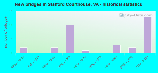
- New bridges - historical statistics
- 21930-1939
- 21950-1959
- 101960-1969
- 11970-1979
- 31990-1999
- 22000-2009
- 132010-2019

- Reconstructed bridges - Historical Statistics
- 11980-1989
- 01990-1999
- 12000-2009
- 12010-2019


- Bridge Condition - Deck
- 5.3%Very good
- 57.9%Good
- 21.1%Satisfactory
- 15.8%Fair

- Bridge Condition - Superstructure
- 31.6%Very good
- 26.3%Good
- 21.1%Satisfactory
- 15.8%Fair
- 5.3%Poor

- Bridge Condition - Substructure
- 21.1%Very good
- 36.8%Good
- 15.8%Satisfactory
- 26.3%Fair

- Bridge Condition - Channel
- 6.3%Very good
- 18.8%Good
- 68.8%Satisfactory
- 6.3%Fair

- Bridge Condition - Culverts
- 20.0%Good
- 80.0%Satisfactory
Find on map >> Show street view
Structure Number: 18052, Location: 9.4M PR.WM.-6.6M FRDBURG (Lat: 38.402239, Lng: -77.421364), Route carried "on" structure: US 1, Year Built: 1933, Status: Open, Structure Length: 1.31m (4.30ft), Average Daily Traffic: 13,754 (year 2020), Truck Traffic: 2%, Average Future Daily Traffic: 17,169 (year 2040), Design Load: H 15, Features Intersected: ACCAKEEK CREEK, Facility Carried by Structure: JEFF. DAVIS HWY.
Minimum Vertical Clearance: 30+ m (98+ ft), Kilometerpoint: 249.672, Lanes on structure: 4, Base Highway Network: Yes, Owner: State Highway Agency, Approaching Roadway Width: 12.2m (40.0ft), Material/Design: Concrete, Design/Construction: Tee Beam, Number Of Spans In Main Unit: 1, Length of Maximum Span: 12.5m (41.0ft), Curb-To-Curb Width: 13.1m (43.0ft), Out-to-Out Width: 13.7m (44.9ft)
Condition: Deck: Fair, Superstructure: Satisfactory, Substructure: Fair, Channel: Satisfactory, Operating Rating: 47.3 metric tons, Method Used To Determine Operating Rating: Load and Resistance Factor (LRFR), Inventory Rating: 36.5 metric tons, Method Used To Determine Inventory Rating: Load and Resistance Factor (LRFR), Structural Evaluation: Somewhat better than minimum adequacy, Deck Geometry: High priority of replacement, Waterway Adequacy: Equal to present minimum criteria, Approach Roadway Alignment: Equal to present desirable criteria, Length Of Structure Improvement: 1.52m (4.99ft), Designated Inspection Frequency: Every 24 months, Inspection Date: October 2020, Bridge Improvement Cost: $450,000, Roadway Improvement Cost: $150,000, Total Project Cost: $600,000, Deck Structure Type: Concrete Cast-file-Place, Wearing Surface/Protective System: Wearing Surface: Bituminous
Find on map >> Show street view
Structure Number: 18087, Location: 6.9M RTE17-3.2M RTE610 (Lat: 38.421928, Lng: -77.422564), Route carried "on" structure: Interstate 95, Year Built: 1963, Year Reconstructed: 1987, Status: Open, Structure Length: 3.93m (12.89ft), Average Daily Traffic: 59,917 (year 2020), Truck Traffic: 10%, Average Future Daily Traffic: 83,884 (year 2040), Design Load: HS 20+Mod, Features Intersected: ROUTE 0630
Minimum Vertical Clearance: 30+ m (98+ ft), Kilometerpoint: 226.505, Lanes on structure: 3, Lanes under structure: 2, Base Highway Network: Yes, Owner: State Highway Agency, Approaching Roadway Width: 11.0m (36.1ft), Skew: 1 degrees, Material/Design: Concrete, Design/Construction: Tee Beam, Number Of Spans In Main Unit: 3, Length of Maximum Span: 13.4m (44.0ft), Curb-To-Curb Width: 19.7m (64.6ft), Out-to-Out Width: 20.7m (67.9ft)
Condition: Deck: Satisfactory, Superstructure: Fair, Substructure: Fair, Operating Rating: 47.4 metric tons, Method Used To Determine Operating Rating: Load and Resistance Factor (LRFR), Inventory Rating: 36.6 metric tons, Method Used To Determine Inventory Rating: Load and Resistance Factor (LRFR), Structural Evaluation: Somewhat better than minimum adequacy, Deck Geometry: Superior to present desirable criteria, Underclear: High priority of corrective action, Approach Roadway Alignment: Equal to present desirable criteria, Designated Inspection Frequency: Every 24 months, Inspection Date: October 2020, Deck Structure Type: Concrete Cast-file-Place, Wearing Surface/Protective System: Wearing Surface: Latex Concrete
Find on map >> Show street view
Structure Number: 18089, Location: 6.9M RTE17-3.2M RTE610 (Lat: 38.421775, Lng: -77.421539), Route carried "on" structure: Interstate 95, Year Built: 1963, Status: Open, Structure Length: 4.42m (14.50ft), Average Daily Traffic: 58,902 (year 2020), Truck Traffic: 10%, Average Future Daily Traffic: 82,463 (year 2040), Design Load: HS 20+Mod, Features Intersected: ROUTE 0630
Minimum Vertical Clearance: 30+ m (98+ ft), Kilometerpoint: 226.258, Lanes on structure: 3, Lanes under structure: 2, Base Highway Network: Yes, Owner: State Highway Agency, Approaching Roadway Width: 11.0m (36.1ft), Skew: 2 degrees, Material/Design: Concrete, Design/Construction: Tee Beam, Number Of Spans In Main Unit: 3, Length of Maximum Span: 16.2m (53.1ft), Curb-To-Curb Width: 19.7m (64.6ft), Out-to-Out Width: 20.7m (67.9ft)
Condition: Deck: Satisfactory, Superstructure: Satisfactory, Substructure: Fair, Operating Rating: 50.1 metric tons, Method Used To Determine Operating Rating: Load and Resistance Factor (LRFR), Inventory Rating: 38.6 metric tons, Method Used To Determine Inventory Rating: Load and Resistance Factor (LRFR), Structural Evaluation: Somewhat better than minimum adequacy, Deck Geometry: Superior to present desirable criteria, Underclear: High priority of corrective action, Approach Roadway Alignment: Equal to present desirable criteria, Designated Inspection Frequency: Every 24 months, Inspection Date: October 2020, Deck Structure Type: Concrete Cast-file-Place, Wearing Surface/Protective System: Wearing Surface: Latex Concrete
Find on map >> Show street view
Structure Number: 18093, Location: 0.2M RTE 8900-3.5M RTE630 (Lat: 38.380494, Lng: -77.455839), Route carried "on" structure: Interstate 95, Year Built: 1963, Status: Open, Structure Length: 4.18m (13.71ft), Average Daily Traffic: 59,162 (year 2020), Truck Traffic: 10%, Average Future Daily Traffic: 82,827 (year 2040), Design Load: HS 20+Mod, Features Intersected: POTOMAC CREEK
Minimum Vertical Clearance: 30+ m (98+ ft), Kilometerpoint: 220.996, Lanes on structure: 3, Base Highway Network: Yes, Owner: State Highway Agency, Approaching Roadway Width: 11.0m (36.1ft), Skew: 1 degrees, Material/Design: Concrete, Design/Construction: Tee Beam, Number Of Spans In Main Unit: 3, Length of Maximum Span: 14.0m (45.9ft), Curb-To-Curb Width: 19.7m (64.6ft), Out-to-Out Width: 20.7m (67.9ft)
Condition: Deck: Good, Superstructure: Satisfactory, Substructure: Satisfactory, Channel: Satisfactory, Operating Rating: 47.3 metric tons, Method Used To Determine Operating Rating: Load and Resistance Factor (LRFR), Inventory Rating: 36.4 metric tons, Method Used To Determine Inventory Rating: Load and Resistance Factor (LRFR), Structural Evaluation: Equal to present minimum criteria, Deck Geometry: Superior to present desirable criteria, Waterway Adequacy: Equal to present minimum criteria, Approach Roadway Alignment: Equal to present desirable criteria, Designated Inspection Frequency: Every 24 months, Inspection Date: October 2020, Deck Structure Type: Concrete Cast-file-Place, Wearing Surface/Protective System: Wearing Surface: Latex Concrete
Find on map >> Show street view
Structure Number: 18101, Location: 5.8M RTE17-1.1M RTE630 (Lat: 38.407244, Lng: -77.431244), Route carried "on" structure: Interstate 95, Year Built: 1964, Status: Open, Structure Length: 1.28m (4.20ft), Average Daily Traffic: 59,162 (year 2020), Truck Traffic: 10%, Average Future Daily Traffic: 82,827 (year 2040), Design Load: HS 20, Features Intersected: ACCAKEEK CREEK
Minimum Vertical Clearance: 30+ m (98+ ft), Kilometerpoint: 224.858, Lanes on structure: 6, Base Highway Network: Yes, Owner: State Highway Agency, Approaching Roadway Width: 11.0m (36.1ft), Material/Design: Concrete, Design/Construction: Culvert, Number Of Spans In Main Unit: 4, Length of Maximum Span: 3.0m (9.8ft)
Condition: Channel: Satisfactory, Culverts: Satisfactory, Operating Rating: 89.8 metric tons, Method Used To Determine Operating Rating: Load Factor (LF), Inventory Rating: 66.2 metric tons, Method Used To Determine Inventory Rating: Load Factor (LF), Structural Evaluation: Equal to present minimum criteria, Waterway Adequacy: Superior to present desirable criteria, Approach Roadway Alignment: Equal to present desirable criteria, Designated Inspection Frequency: Every 24 months, Inspection Date: October 2021
Find on map >> Show street view
Structure Number: 18126, Location: 2.5M RTE607-1.6M RTE628 (Lat: 38.356450, Lng: -77.395728), Route carried "on" structure: County highway 608, Year Built: 1957, Year Reconstructed: 2011, Status: Open, Structure Length: 3.06m (10.04ft), Average Daily Traffic: 2,343 (year 2020), Truck Traffic: 2%, Average Future Daily Traffic: 3,280 (year 2040), Design Load: HS 20+Mod, Features Intersected: POTOMAC CREEK, Facility Carried by Structure: BROOKE RD.
Minimum Vertical Clearance: 30+ m (98+ ft), Kilometerpoint: 6.259, Lanes on structure: 2, Owner: State Highway Agency, Approaching Roadway Width: 5.5m (18.0ft), Material/Design: Steel, Design/Construction: Stringer/Multi-beam, Number Of Spans In Main Unit: 3, Length of Maximum Span: 9.9m (32.5ft), Curb-To-Curb Width: 7.3m (24.0ft), Out-to-Out Width: 8.0m (26.2ft)
Condition: Deck: Good, Superstructure: Very good, Substructure: Satisfactory, Channel: Satisfactory, Operating Rating: 78.4 metric tons, Method Used To Determine Operating Rating: Load and Resistance Factor (LRFR), Inventory Rating: 60.3 metric tons, Method Used To Determine Inventory Rating: Load and Resistance Factor (LRFR), Structural Evaluation: Equal to present minimum criteria, Deck Geometry: High priority of replacement, Waterway Adequacy: Better than present minimum criteria, Approach Roadway Alignment: Equal to present desirable criteria, Length Of Structure Improvement: 3.05m (10.01ft), Designated Inspection Frequency: Every 24 months, Inspection Date: November 2021, Bridge Improvement Cost: $50,000, Roadway Improvement Cost: $10,000, Total Project Cost: $60,000, Deck Structure Type: Concrete Cast-file-Place, Wearing Surface/Protective System: Deck Protection: Other Coated Reinforcing
Find on map >> Show street view
Structure Number: 18127, Location: 0.1M RTE677-0.3M RTE629 (Lat: 38.384139, Lng: -77.383753), Route carried "on" structure: County highway 608, Year Built: 1958, Status: Open, Structure Length: 3.20m (10.50ft), Average Daily Traffic: 1,825 (year 2020), Truck Traffic: 2%, Average Future Daily Traffic: 2,555 (year 2040), Design Load: HS 15, Features Intersected: ACCOKEEK CREEK, Facility Carried by Structure: BROOKE RD.
Minimum Vertical Clearance: 30+ m (98+ ft), Kilometerpoint: 10.040, Lanes on structure: 2, Owner: State Highway Agency, Approaching Roadway Width: 6.1m (20.0ft), Skew: 3 degrees, Material/Design: Concrete continuous, Design/Construction: Slab, Number Of Spans In Main Unit: 3, Length of Maximum Span: 12.2m (40.0ft), Curb or Sidewalk Widths: Left: 0.5m (1.6ft), Right: 0.5m (1.6ft), Curb-To-Curb Width: 7.3m (24.0ft), Out-to-Out Width: 8.2m (26.9ft)
Condition: Deck: Fair, Superstructure: Fair, Substructure: Fair, Channel: Satisfactory, Operating Rating: 38.2 metric tons, Method Used To Determine Operating Rating: Load Testing, Inventory Rating: 22.9 metric tons, Method Used To Determine Inventory Rating: Load Testing, Structural Evaluation: Somewhat better than minimum adequacy, Deck Geometry: Meets minimum limits, Waterway Adequacy: Better than present minimum criteria, Approach Roadway Alignment: Equal to present desirable criteria, Designated Inspection Frequency: Every 24 months, Inspection Date: November 2020, Deck Structure Type: Concrete Cast-file-Place, Wearing Surface/Protective System: Wearing Surface: Monolithic Concrete
Find on map >> Show street view
Structure Number: 18128, Location: 2.3M RTE607-1.8M RTE628 (Lat: 38.349183, Lng: -77.396036), Route carried "on" structure: County highway 608, Year Built: 1932, Year Reconstructed: 2019, Status: Open, Structure Length: 0.64m (2.10ft), Average Daily Traffic: 2,343 (year 2020), Truck Traffic: 2%, Average Future Daily Traffic: 3,280 (year 2040), Design Load: HS 20+Mod, Features Intersected: TRIB. POTOMAC CREEK, Facility Carried by Structure: BROOKE ROAD
Minimum Vertical Clearance: 30+ m (98+ ft), Kilometerpoint: 5.953, Lanes on structure: 2, Owner: State Highway Agency, Approaching Roadway Width: 6.7m (22.0ft), Material/Design: Concrete, Design/Construction: Culvert, Number Of Spans In Main Unit: 2, Length of Maximum Span: 3.0m (9.8ft)
Condition: Channel: Satisfactory, Culverts: Satisfactory, Operating Rating: 44.5 metric tons, Method Used To Determine Operating Rating: Field evaluation and documented engineering judgment, Inventory Rating: 32.7 metric tons, Method Used To Determine Inventory Rating: Field evaluation and documented engineering judgment, Structural Evaluation: Equal to present minimum criteria, Waterway Adequacy: Better than present minimum criteria, Approach Roadway Alignment: Equal to present desirable criteria, Designated Inspection Frequency: Every 24 months, Inspection Date: November 2021
Find on map >> Show street view
Structure Number: 18145, Location: 0.2M RTE608-0.01M RTE619 (Lat: 38.376933, Lng: -77.397508), Route carried "on" structure: County highway 628, Year Built: 1972, Status: Posted for load, Structure Length: 4.39m (14.40ft), Average Daily Traffic: 1,443 (year 2020), Truck Traffic: 3%, Average Future Daily Traffic: 1,836 (year 2040), Design Load: HS 20+Mod, Features Intersected: CSX RAILROAD, Facility Carried by Structure: ESKIMO HILL RD.
Minimum Vertical Clearance: 30+ m (98+ ft), Kilometerpoint: 15.660, Lanes on structure: 2, Owner: State Highway Agency, Approaching Roadway Width: 6.7m (22.0ft), Material/Design: Steel, Design/Construction: Stringer/Multi-beam, Number Of Spans In Main Unit: 3, Length of Maximum Span: 16.2m (53.1ft), Curb-To-Curb Width: 9.1m (29.9ft), Out-to-Out Width: 10.4m (34.1ft)
Condition: Deck: Satisfactory, Superstructure: Poor, Substructure: Satisfactory, Operating Rating: 22.6 metric tons, Method Used To Determine Operating Rating: Load and Resistance Factor (LRFR), Inventory Rating: 17.4 metric tons, Method Used To Determine Inventory Rating: Load and Resistance Factor (LRFR), Structural Evaluation: Meets minimum limits, Deck Geometry: Somewhat better than minimum adequacy, Underclear: Equal to present minimum criteria, Approach Roadway Alignment: Equal to present desirable criteria, Bridge Posting: Required (Relationship of Operating Rating to Maximum Legal Load: 0.1 - 9.9% below), Designated Inspection Frequency: Every 12 months, Inspection Date: November 2020, Deck Structure Type: Concrete Cast-file-Place, Wearing Surface/Protective System: Wearing Surface: Monolithic Concrete
Find on map >> Show street view
Structure Number: 18146, Location: 0.3M RTE1-2.9M RTE651 (Lat: 38.397739, Lng: -77.435761), Route carried "on" structure: County highway 628, Year Built: 1964, Status: Open, Structure Length: 8.69m (28.51ft), Average Daily Traffic: 2,290 (year 2020), Truck Traffic: 3%, Average Future Daily Traffic: 3,206 (year 2040), Design Load: HS 15, Features Intersected: ROUTE I-95, Facility Carried by Structure: AMERICAN LEGION RD
Minimum Vertical Clearance: 30+ m (98+ ft), Kilometerpoint: 10.598, Lanes on structure: 2, Lanes under structure: 6, Owner: State Highway Agency, Approaching Roadway Width: 6.7m (22.0ft), Material/Design: Steel, Design/Construction: Stringer/Multi-beam, Number Of Spans In Main Unit: 5, Length of Maximum Span: 19.5m (64.0ft), Curb or Sidewalk Widths: Left: 0.5m (1.6ft), Right: 0.5m (1.6ft), Curb-To-Curb Width: 7.3m (24.0ft), Out-to-Out Width: 8.8m (28.9ft)
Condition: Deck: Fair, Superstructure: Satisfactory, Substructure: Fair, Operating Rating: 50.7 metric tons, Method Used To Determine Operating Rating: Load and Resistance Factor (LRFR), Inventory Rating: 39.1 metric tons, Method Used To Determine Inventory Rating: Load and Resistance Factor (LRFR), Structural Evaluation: Somewhat better than minimum adequacy, Deck Geometry: High priority of replacement, Underclear: Better than present minimum criteria, Approach Roadway Alignment: Equal to present minimum criteria, Length Of Structure Improvement: 8.69m (28.51ft), Designated Inspection Frequency: Every 24 months, Inspection Date: November 2021, Bridge Improvement Cost: $430,000, Roadway Improvement Cost: $20,000, Total Project Cost: $450,000, Deck Structure Type: Concrete Cast-file-Place, Wearing Surface/Protective System: Wearing Surface: Monolithic Concrete
Find on map >> Show street view
Structure Number: 18148, Location: 0.8M RTE651 & 1.0M RTE630 (Lat: 38.432953, Lng: -77.466492), Route carried "on" structure: County highway 628, Year Built: 1964, Status: Open, Structure Length: 0.64m (2.10ft), Average Daily Traffic: 2,079 (year 2020), Truck Traffic: 2%, Average Future Daily Traffic: 2,911 (year 2040), Design Load: HS 20, Features Intersected: ACCAKEEK CREEK, Facility Carried by Structure: RAMOTH CH. RD.
Minimum Vertical Clearance: 30+ m (98+ ft), Kilometerpoint: 4.788, Lanes on structure: 2, Owner: State Highway Agency, Approaching Roadway Width: 6.4m (21.0ft), Material/Design: Concrete, Design/Construction: Culvert, Number Of Spans In Main Unit: 2, Length of Maximum Span: 3.0m (9.8ft)
Condition: Channel: Satisfactory, Culverts: Satisfactory, Operating Rating: 44.5 metric tons, Method Used To Determine Operating Rating: Field evaluation and documented engineering judgment, Inventory Rating: 32.7 metric tons, Method Used To Determine Inventory Rating: Field evaluation and documented engineering judgment, Structural Evaluation: Equal to present minimum criteria, Waterway Adequacy: Better than present minimum criteria, Approach Roadway Alignment: Equal to present desirable criteria, Designated Inspection Frequency: Every 24 months, Inspection Date: November 2021
Find on map >> Show street view
Structure Number: 24868, Location: 1.4M RTE610-0.4M RTE1486 (Lat: 38.452856, Lng: -77.425342), Route carried "on" structure: County highway 684, Year Built: 1995, Status: Open, Structure Length: 0.88m (2.89ft), Average Daily Traffic: 10,542 (year 2020), Average Future Daily Traffic: 14,759 (year 2040), Design Load: HS 20+Mod, Features Intersected: AUSTIN RUN, Facility Carried by Structure: MINE RD.
Minimum Vertical Clearance: 30+ m (98+ ft), Kilometerpoint: 0.644, Lanes on structure: 2, Owner: State Highway Agency, Approaching Roadway Width: 7.3m (24.0ft), Skew: 4 degrees, Material/Design: Concrete, Design/Construction: Culvert, Number Of Spans In Main Unit: 2, Length of Maximum Span: 4.3m (14.1ft)
Condition: Channel: Fair, Culverts: Satisfactory, Operating Rating: 89.8 metric tons, Method Used To Determine Operating Rating: Load Factor (LF), Inventory Rating: 89.8 metric tons, Method Used To Determine Inventory Rating: Load Factor (LF), Structural Evaluation: Equal to present minimum criteria, Waterway Adequacy: Better than present minimum criteria, Approach Roadway Alignment: Equal to present desirable criteria, Designated Inspection Frequency: Every 24 months, Inspection Date: November 2020
Find on map >> Show street view
Structure Number: 27143, Location: 1.10M RTE.610-.85M RTE733 (Lat: 38.457703, Lng: -77.438186), Route carried "on" structure: County highway 751, Year Built: 1996, Status: Open, Structure Length: 1.04m (3.41ft), Average Daily Traffic: 2,987 (year 2012), Average Future Daily Traffic: 3,405 (year 2040), Design Load: HS 20, Features Intersected: AUSTIN RUN, Facility Carried by Structure: EUSTACE RD.
Minimum Vertical Clearance: 30+ m (98+ ft), Kilometerpoint: 0.869, Lanes on structure: 2, Owner: State Highway Agency, Approaching Roadway Width: 7.3m (24.0ft), Material/Design: Concrete, Design/Construction: Arch - Deck, Number Of Spans In Main Unit: 1, Length of Maximum Span: 9.8m (32.2ft), Curb-To-Curb Width: 10.9m (35.8ft), Out-to-Out Width: 29.3m (96.1ft)
Condition: Deck: Good, Superstructure: Good, Substructure: Good, Channel: Satisfactory, Operating Rating: 48.5 metric tons, Method Used To Determine Operating Rating: Load and Resistance Factor (LRFR), Inventory Rating: 34.3 metric tons, Method Used To Determine Inventory Rating: Load and Resistance Factor (LRFR), Structural Evaluation: Better than present minimum criteria, Deck Geometry: Somewhat better than minimum adequacy, Waterway Adequacy: Better than present minimum criteria, Approach Roadway Alignment: Equal to present desirable criteria, Designated Inspection Frequency: Every 24 months, Inspection Date: November 2021
Find on map >> Show street view
Structure Number: 27898, Location: 0.4M RTE629-0.6M RTE666 (Lat: 38.399067, Lng: -77.368150), Route carried "on" structure: County highway 630, Year Built: 2011, Status: Open, Structure Length: 5.73m (18.80ft), Average Daily Traffic: 623 (year 2020), Average Future Daily Traffic: 863 (year 2040), Design Load: HS 20, Features Intersected: CSX RAILROAD, Facility Carried by Structure: COURTHOUSE ROAD
Minimum Vertical Clearance: 30.18m (99.02ft), Kilometerpoint: 0.000, Lanes on structure: 2, Owner: State Highway Agency, Approaching Roadway Width: 7.3m (24.0ft), Skew: 2 degrees, Material/Design: Prestressed concrete, Design/Construction: Stringer/Multi-beam, Number Of Spans In Main Unit: 3, Length of Maximum Span: 28.0m (91.9ft), Curb-To-Curb Width: 9.8m (32.2ft), Out-to-Out Width: 10.8m (35.4ft)
Condition: Deck: Good, Superstructure: Good, Substructure: Good, Operating Rating: 86.6 metric tons, Method Used To Determine Operating Rating: Load and Resistance Factor (LRFR), Inventory Rating: 66.9 metric tons, Method Used To Determine Inventory Rating: Load and Resistance Factor (LRFR), Structural Evaluation: Better than present minimum criteria, Deck Geometry: Equal to present minimum criteria, Underclear: Superior to present desirable criteria, Approach Roadway Alignment: Equal to present desirable criteria, Designated Inspection Frequency: Every 24 months, Inspection Date: November 2020, Deck Structure Type: Concrete Cast-file-Place, Wearing Surface/Protective System: Deck Protection: Epoxy Coated Reinforcing
Find on map >> Show street view
Structure Number: 28118, Location: 0.5M RTE2058-1.1M RTE 630 (Lat: 38.443442, Lng: -77.470231), Route carried "on" structure: County highway 2050, Year Built: 1998, Status: Open, Structure Length: 1.52m (4.99ft), Average Daily Traffic: 2,016 (year 2008), Average Future Daily Traffic: 2,339 (year 2040), Design Load: HS 20, Features Intersected: ACCOKEEK CREEK, Facility Carried by Structure: MONUMENT DR.
Minimum Vertical Clearance: 30+ m (98+ ft), Kilometerpoint: 0.901, Lanes on structure: 2, Owner: State Highway Agency, Approaching Roadway Width: 6.7m (22.0ft), Material/Design: Concrete, Design/Construction: Culvert, Number Of Spans In Main Unit: 5, Length of Maximum Span: 2.1m (6.9ft)
Condition: Channel: Satisfactory, Culverts: Good, Operating Rating: 44.5 metric tons, Method Used To Determine Operating Rating: Field evaluation and documented engineering judgment, Inventory Rating: 32.7 metric tons, Method Used To Determine Inventory Rating: Field evaluation and documented engineering judgment, Structural Evaluation: Better than present minimum criteria, Waterway Adequacy: Equal to present desirable criteria, Approach Roadway Alignment: Equal to present desirable criteria, Designated Inspection Frequency: Every 24 months, Inspection Date: November 2020
Find on map >> Show street view
Structure Number: 28119, Location: 0.5MRTE.684-0.1M RTE.1924 (Lat: 38.441833, Lng: -77.420939), Route carried "on" structure: County highway 1486, Year Built: 2002, Status: Open, Structure Length: 1.13m (3.71ft), Average Daily Traffic: 8,084 (year 2015), Average Future Daily Traffic: 9,094 (year 2040), Design Load: HS 20, Features Intersected: AUSTIN RUN, Facility Carried by Structure: AUSTIN RIDGE DR.
Minimum Vertical Clearance: 30+ m (98+ ft), Kilometerpoint: 0.805, Lanes on structure: 2, Owner: State Highway Agency, Approaching Roadway Width: 10.4m (34.1ft), Skew: 3 degrees, Material/Design: Concrete, Design/Construction: Arch - Deck, Number Of Spans In Main Unit: 1, Length of Maximum Span: 11.3m (37.1ft), Curb-To-Curb Width: 11.0m (36.1ft), Out-to-Out Width: 53.0m (173.9ft)
Condition: Deck: Good, Superstructure: Good, Substructure: Good, Channel: Good, Operating Rating: 89.5 metric tons, Method Used To Determine Operating Rating: Load and Resistance Factor (LRFR), Inventory Rating: 65.1 metric tons, Method Used To Determine Inventory Rating: Load and Resistance Factor (LRFR), Structural Evaluation: Better than present minimum criteria, Deck Geometry: Meets minimum limits, Waterway Adequacy: Equal to present desirable criteria, Approach Roadway Alignment: Equal to present desirable criteria, Designated Inspection Frequency: Every 24 months, Inspection Date: November 2020
Find on map >> Show street view
Structure Number: 29004, Location: .1 M RTE. 2074-.1 M DE EN (Lat: 38.443533, Lng: -77.461328), Route carried "on" structure: County highway 2075, Year Built: 2007, Status: Open, Structure Length: 0.73m (2.40ft), Average Daily Traffic: 103 (year 2012), Average Future Daily Traffic: 117 (year 2040), Design Load: HS 20+Mod, Features Intersected: ACCAKEEK CREEK, Facility Carried by Structure: BRANNIGAN DR.
Minimum Vertical Clearance: 30+ m (98+ ft), Kilometerpoint: 0.129, Lanes on structure: 2, Owner: State Highway Agency, Approaching Roadway Width: 6.1m (20.0ft), Material/Design: Concrete, Design/Construction: Arch - Deck, Number Of Spans In Main Unit: 1, Length of Maximum Span: 7.3m (24.0ft), Curb-To-Curb Width: 8.2m (26.9ft), Out-to-Out Width: 36.8m (120.7ft)
Condition: Deck: Very good, Superstructure: Very good, Substructure: Good, Channel: Good, Operating Rating: 99.8 metric tons, Method Used To Determine Operating Rating: Load and Resistance Factor (LRFR), Inventory Rating: 99.8 metric tons, Method Used To Determine Inventory Rating: Load and Resistance Factor (LRFR), Structural Evaluation: Better than present minimum criteria, Deck Geometry: Somewhat better than minimum adequacy, Waterway Adequacy: Equal to present desirable criteria, Approach Roadway Alignment: Equal to present desirable criteria, Designated Inspection Frequency: Every 24 months, Inspection Date: November 2020
Find on map >> Show street view
Structure Number: 29983, Location: 0.4M Rte. 1-2.4M Rte. 628 (Lat: 38.420725, Lng: -77.423528), Route carried "on" structure: State highway 630, Year Built: 2019, Status: Open, Structure Length: 9.52m (31.23ft), Average Daily Traffic: 6,995 (year 2020), Truck Traffic: 5%, Average Future Daily Traffic: 9,793 (year 2040), Design Load: HL 93, Features Intersected: I-95 NB & SB, Facility Carried by Structure: Courthouse Road EB
Minimum Vertical Clearance: 3.05m (10.01ft), Kilometerpoint: 0.000, Lanes on structure: 3, Lanes under structure: 6, Owner: State Highway Agency, Approaching Roadway Width: 11.0m (36.1ft), Material/Design: Prestressed concrete, Design/Construction: Stringer/Multi-beam, Number Of Spans In Main Unit: 3, Length of Maximum Span: 30.2m (99.1ft), Curb-To-Curb Width: 11.0m (36.1ft), Out-to-Out Width: 17.0m (55.8ft)
Condition: Deck: Good, Superstructure: Very good, Substructure: Very good, Operating Rating: 91.0 metric tons, Method Used To Determine Operating Rating: Load and Resistance Factor (LRFR), Inventory Rating: 55.9 metric tons, Method Used To Determine Inventory Rating: Load and Resistance Factor (LRFR), Structural Evaluation: Equal to present desirable criteria, Deck Geometry: High priority of replacement, Underclear: High priority of corrective action, Approach Roadway Alignment: Equal to present desirable criteria, Designated Inspection Frequency: Every 24 months, Inspection Date: November 2021, Deck Structure Type: Concrete Cast-file-Place, Wearing Surface/Protective System: Deck Protection: Other Coated Reinforcing
Find on map >> Show street view
Structure Number: 29984, Location: 0.4M Rte.1-2.4M Rte 628 (Lat: 38.420556, Lng: -77.423528), Route carried "on" structure: State highway 630, Year Built: 2019, Status: Open, Structure Length: 9.52m (31.23ft), Average Daily Traffic: 4,674 (year 2020), Truck Traffic: 5%, Average Future Daily Traffic: 5,141 (year 2040), Design Load: HL 93, Features Intersected: I-95 NB & SB, Facility Carried by Structure: Courthouse Road WB
Minimum Vertical Clearance: 3.05m (10.01ft), Kilometerpoint: 0.000, Lanes on structure: 3, Lanes under structure: 6, Owner: State Highway Agency, Approaching Roadway Width: 11.0m (36.1ft), Material/Design: Prestressed concrete, Design/Construction: Stringer/Multi-beam, Number Of Spans In Main Unit: 3, Length of Maximum Span: 30.2m (99.1ft), Curb-To-Curb Width: 11.0m (36.1ft), Out-to-Out Width: 12.5m (41.0ft)
Condition: Deck: Good, Superstructure: Very good, Substructure: Very good, Operating Rating: 89.0 metric tons, Method Used To Determine Operating Rating: Load and Resistance Factor (LRFR), Inventory Rating: 58.0 metric tons, Method Used To Determine Inventory Rating: Load and Resistance Factor (LRFR), Structural Evaluation: Equal to present desirable criteria, Deck Geometry: High priority of replacement, Underclear: High priority of corrective action, Approach Roadway Alignment: Equal to present desirable criteria, Designated Inspection Frequency: Every 24 months, Inspection Date: November 2021, Deck Structure Type: Concrete Cast-file-Place, Wearing Surface/Protective System: Deck Protection: Other Coated Reinforcing
Find on map >> Show street view
Structure Number: 30693, Location: 0.5M RTE.630-0.7M RTE.651 (Lat: 38.431500, Lng: -77.460861), Route carried "on" structure: County highway 2350, Year Built: 2015, Status: Open, Structure Length: 1.98m (6.50ft), Average Daily Traffic: 500 (year 2015), Average Future Daily Traffic: 600 (year 2035), Design Load: HL 93, Features Intersected: Accokeek Creek, Facility Carried by Structure: Woodcutters Rd
Minimum Vertical Clearance: 30+ m (98+ ft), Kilometerpoint: 0.000, Lanes on structure: 4, Owner: State Highway Agency, Approaching Roadway Width: 15.2m (49.9ft), Material/Design: Concrete, Design/Construction: Arch - Deck, Number Of Spans In Main Unit: 1, Length of Maximum Span: 19.8m (65.0ft), Curb-To-Curb Width: 7.6m (24.9ft), Out-to-Out Width: 36.6m (120.1ft)
Condition: Deck: Good, Superstructure: Good, Substructure: Good, Channel: Satisfactory, Operating Rating: 99.8 metric tons, Method Used To Determine Operating Rating: Load and Resistance Factor (LRFR), Inventory Rating: 84.4 metric tons, Method Used To Determine Inventory Rating: Load and Resistance Factor (LRFR), Structural Evaluation: Better than present minimum criteria, Deck Geometry: High priority of replacement, Waterway Adequacy: Equal to present desirable criteria, Approach Roadway Alignment: Equal to present desirable criteria, Designated Inspection Frequency: Every 24 months, Inspection Date: November 2021
Find on map >> Show street view
Structure Number: 30755, Location: 0.1M RTE608-1.3M DEAD END (Lat: 38.377144, Lng: -77.357025), Route carried "on" structure: County highway 609, Year Built: 2016, Status: Open, Structure Length: 2.47m (8.10ft), Average Daily Traffic: 226 (year 2012), Average Future Daily Traffic: 353 (year 2040), Design Load: HS 20+Mod, Features Intersected: ACCAKEEK CREEK, Facility Carried by Structure: RAVEN ROAD
Minimum Vertical Clearance: 30+ m (98+ ft), Kilometerpoint: 0.000, Lanes on structure: 1, Base Highway Network: Yes, Owner: State Highway Agency, Approaching Roadway Width: 5.2m (17.1ft), Material/Design: Steel, Design/Construction: Truss - Thru, Number Of Spans In Main Unit: 1, Length of Maximum Span: 23.6m (77.4ft), Curb-To-Curb Width: 3.4m (11.2ft), Out-to-Out Width: 3.5m (11.5ft)
Condition: Deck: Satisfactory, Superstructure: Fair, Substructure: Good, Channel: Satisfactory, Operating Rating: 53.6 metric tons, Method Used To Determine Operating Rating: Load Factor (LF), Inventory Rating: 32.1 metric tons, Method Used To Determine Inventory Rating: Load Factor (LF), Structural Evaluation: Somewhat better than minimum adequacy, Deck Geometry: High priority of replacement, Waterway Adequacy: Equal to present minimum criteria, Approach Roadway Alignment: Equal to present minimum criteria, Designated Inspection Frequency: Every 12 months, Critical Feature Inspection Frequency: Every 12 months, Inspection Date: November 2021, Critical Feature Inspection Date: November 2021, Deck Structure Type: Wood or Timber
Find on map >> Show street view
Structure Number: 3087, Location: 0.1M Rte 630-0.1M Rte 95N (Lat: 38.421806, Lng: -77.420694), Route carried "on" structure: Interstate 95, Year Built: 2019, Status: Open, Structure Length: 1.87m (6.14ft), Average Daily Traffic: 4,674 (year 2020), Truck Traffic: 7%, Average Future Daily Traffic: 5,141 (year 2040), Design Load: HL 93, Features Intersected: Existing Rte. 630, Facility Carried by Structure: Ramp A
Minimum Vertical Clearance: 3.05m (10.01ft), Kilometerpoint: 0.000, Lanes on structure: 2, Lanes under structure: 3, Owner: State Highway Agency, Approaching Roadway Width: 11.6m (38.1ft), Material/Design: Prestressed concrete, Design/Construction: Stringer/Multi-beam, Number Of Spans In Main Unit: 1, Length of Maximum Span: 16.9m (55.4ft), Curb-To-Curb Width: 12.2m (40.0ft), Out-to-Out Width: 13.2m (43.3ft)
Condition: Deck: Good, Superstructure: Very good, Substructure: Very good, Operating Rating: 73.2 metric tons, Method Used To Determine Operating Rating: Load and Resistance Factor (LRFR), Inventory Rating: 49.6 metric tons, Method Used To Determine Inventory Rating: Load and Resistance Factor (LRFR), Structural Evaluation: Equal to present desirable criteria, Deck Geometry: High priority of corrective action, Underclear: High priority of corrective action, Approach Roadway Alignment: Equal to present desirable criteria, Designated Inspection Frequency: Every 24 months, Inspection Date: November 2021, Deck Structure Type: Concrete Cast-file-Place, Wearing Surface/Protective System: Deck Protection: Other Coated Reinforcing
Find on map >> Show street view
Structure Number: 31001, Location: 0.7M Rte 630-0.3 Rte 733 (Lat: 38.436111, Lng: -77.431750), Route carried "on" structure: State highway 684, Year Built: 2016, Status: Open, Structure Length: 3.63m (11.91ft), Average Daily Traffic: 5,041 (year 2014), Truck Traffic: 7%, Average Future Daily Traffic: 6,142 (year 2035), Design Load: HL 93, Features Intersected: Rocky Run, Facility Carried by Structure: Mine Road
Minimum Vertical Clearance: 30+ m (98+ ft), Kilometerpoint: 205.711, Lanes on structure: 4, Base Highway Network: Yes, Owner: State Highway Agency, Approaching Roadway Width: 7.3m (24.0ft), Skew: 3 degrees, Material/Design: Prestressed concrete, Design/Construction: Girder and Floorbeam System, Number Of Spans In Main Unit: 1, Length of Maximum Span: 36.3m (119.1ft), Curb or Sidewalk Widths: Left: 5.5m (18.0ft), Right: 1.8m (5.9ft), Curb-To-Curb Width: 8.2m (26.9ft), Out-to-Out Width: 25.3m (83.0ft)
Condition: Deck: Good, Superstructure: Very good, Substructure: Good, Channel: Very good, Operating Rating: 97.7 metric tons, Method Used To Determine Operating Rating: Load and Resistance Factor (LRFR), Inventory Rating: 70.9 metric tons, Method Used To Determine Inventory Rating: Load and Resistance Factor (LRFR), Structural Evaluation: Better than present minimum criteria, Deck Geometry: High priority of replacement, Waterway Adequacy: Superior to present desirable criteria, Approach Roadway Alignment: Equal to present desirable criteria, Designated Inspection Frequency: Every 24 months, Inspection Date: November 2021, Deck Structure Type: Concrete Cast-file-Place, Wearing Surface/Protective System: Deck Protection: Other Coated Reinforcing
Find on map >> Show street view
Structure Number: 31218, Location: 0.5M RTE.630-0.7M RTE.651 (Lat: 38.432194, Lng: -77.460389), Route carried "on" structure: County highway 2350, Year Built: 2015, Status: Open, Structure Length: 1.10m (3.61ft), Average Daily Traffic: 500 (year 2015), Average Future Daily Traffic: 600 (year 2035), Design Load: HL 93, Features Intersected: Accokeek Creek, Facility Carried by Structure: Woodcutters Rd
Minimum Vertical Clearance: 30+ m (98+ ft), Kilometerpoint: 0.000, Lanes on structure: 4, Owner: State Highway Agency, Approaching Roadway Width: 15.2m (49.9ft), Material/Design: Concrete, Design/Construction: Arch - Deck, Number Of Spans In Main Unit: 1, Length of Maximum Span: 11.0m (36.1ft), Curb-To-Curb Width: 7.6m (24.9ft), Out-to-Out Width: 36.6m (120.1ft)
Condition: Deck: Good, Superstructure: Good, Substructure: Very good, Channel: Good, Operating Rating: 66.2 metric tons, Method Used To Determine Operating Rating: Load and Resistance Factor (LRFR), Inventory Rating: 54.4 metric tons, Method Used To Determine Inventory Rating: Load and Resistance Factor (LRFR), Structural Evaluation: Better than present minimum criteria, Deck Geometry: High priority of replacement, Waterway Adequacy: Equal to present desirable criteria, Approach Roadway Alignment: Equal to present desirable criteria, Designated Inspection Frequency: Every 24 months, Inspection Date: November 2021
Find on map >> Show street view
Structure Number: 18087, Location: 6.9M RTE17-3.2M RTE610 (Lat: 38.421928, Lng: -77.422564), Route carried "under" structure: Interstate 630, Year Built: 1963, Structure Length: 0. m, Average Daily Traffic: 8,171 (year 2019), Truck Traffic: 4%, Features Intersected: ROUTE 0630, Facility Carried by Structure: SBL ROUTE I-95
Minimum Vertical Clearance: 4.54m (14.90ft), Kilometerpoint: 6.533, Lanes on structure: 3, Lanes under structure: 2, Material/Design: Concrete, Design/Construction: Tee Beam, Length of Maximum Span: 13.4m (44.0ft)
Find on map >> Show street view
Structure Number: 18089, Location: 6.9M RTE17-3.2M RTE610 (Lat: 38.421775, Lng: -77.421539), Route carried "under" structure: County highway 630, Year Built: 1963, Structure Length: 0. m, Average Daily Traffic: 8,171 (year 2019), Truck Traffic: 4%, Features Intersected: ROUTE 0630, Facility Carried by Structure: NBL ROUTE I-95
Minimum Vertical Clearance: 4.85m (15.91ft), Kilometerpoint: 6.533, Lanes on structure: 3, Lanes under structure: 2, Material/Design: Concrete, Design/Construction: Tee Beam, Length of Maximum Span: 16.2m (53.1ft)
Find on map >> Show street view
Structure Number: 18146, Location: 0.3M RTE1-2.9M RTE651 (Lat: 38.397739, Lng: -77.435761), Route carried "under" structure: Interstate 95, Year Built: 1964, Structure Length: 0. m, Average Daily Traffic: 66,479 (year 2019), Truck Traffic: 15%, Features Intersected: ROUTE I-95, Facility Carried by Structure: AMERICAN LEGION RD
Minimum Vertical Clearance: 5.05m (16.57ft), Kilometerpoint: 10.169, Lanes on structure: 2, Lanes under structure: 3, Material/Design: Steel, Design/Construction: Stringer/Multi-beam, Length of Maximum Span: 19.5m (64.0ft)
Find on map >> Show street view
Structure Number: 18146, Location: 0.3M RTE1-2.9M RTE651 (Lat: 38.397739, Lng: -77.435761), Route carried "under" structure: Interstate 95, Year Built: 1964, Structure Length: 0. m, Average Daily Traffic: 70,656 (year 2019), Truck Traffic: 15%, Features Intersected: ROUTE I-95, Facility Carried by Structure: AMERICAN LEGION RD
Minimum Vertical Clearance: 5.46m (17.91ft), Kilometerpoint: 10.169, Lanes on structure: 2, Lanes under structure: 3, Material/Design: Steel, Design/Construction: Stringer/Multi-beam, Length of Maximum Span: 19.5m (64.0ft)
Find on map >> Show street view
Structure Number: 29983, Location: 0.4M Rte. 1-2.4M Rte. 628 (Lat: 38.420725, Lng: -77.423528), Route carried "under" structure: Interstate 95, Year Built: 2019, Structure Length: 0. m, Average Daily Traffic: 70,037 (year 2018), Truck Traffic: 10%, Features Intersected: I-95 NB & SB, Facility Carried by Structure: Courthouse Road EB
Minimum Vertical Clearance: 6.17m (20.24ft), Kilometerpoint: 0.000, Lanes on structure: 3, Lanes under structure: 3, Material/Design: Prestressed concrete, Design/Construction: Stringer/Multi-beam, Length of Maximum Span: 30.2m (99.1ft)
Find on map >> Show street view
Structure Number: 29983, Location: 0.4M Rte. 1-2.4M Rte. 628 (Lat: 38.420725, Lng: -77.423528), Route carried "under" structure: Interstate 95, Year Built: 2019, Structure Length: 0. m, Average Daily Traffic: 67,677 (year 2018), Truck Traffic: 10%, Features Intersected: I-95 NB & SB, Facility Carried by Structure: Courthouse Road EB
Minimum Vertical Clearance: 6.78m (22.24ft), Kilometerpoint: 0.000, Lanes on structure: 3, Lanes under structure: 3, Material/Design: Prestressed concrete, Design/Construction: Stringer/Multi-beam, Length of Maximum Span: 30.2m (99.1ft)
Find on map >> Show street view
Structure Number: 29984, Location: 0.4M Rte.1-2.4M Rte 628 (Lat: 38.420556, Lng: -77.423528), Route carried "under" structure: Interstate 95, Year Built: 2019, Structure Length: 0. m, Average Daily Traffic: 70,037 (year 2018), Truck Traffic: 10%, Features Intersected: I-95 NB & SB, Facility Carried by Structure: Courthouse Road WB
Minimum Vertical Clearance: 5.56m (18.24ft), Kilometerpoint: 0.000, Lanes on structure: 3, Lanes under structure: 3, Material/Design: Prestressed concrete, Design/Construction: Stringer/Multi-beam, Length of Maximum Span: 30.2m (99.1ft)
Find on map >> Show street view
Structure Number: 29984, Location: 0.4M Rte.1-2.4M Rte 628 (Lat: 38.420556, Lng: -77.423528), Route carried "under" structure: Interstate 95, Year Built: 2019, Structure Length: 0. m, Average Daily Traffic: 67,677 (year 2018), Truck Traffic: 10%, Features Intersected: I-95 NB & SB, Facility Carried by Structure: Courthouse Road WB
Minimum Vertical Clearance: 6.10m (20.01ft), Kilometerpoint: 0.000, Lanes on structure: 3, Lanes under structure: 3, Material/Design: Prestressed concrete, Design/Construction: Stringer/Multi-beam, Length of Maximum Span: 30.2m (99.1ft)
Find on map >> Show street view
Structure Number: 3087, Location: 0.1M Rte 630-0.1M Rte 95N (Lat: 38.421806, Lng: -77.420694), Route carried "under" structure: State highway 630, Year Built: 2019, Structure Length: 0. m, Average Daily Traffic: 8,052 (year 2018), Truck Traffic: 5%, Features Intersected: Existing Rte. 630, Facility Carried by Structure: Ramp A
Minimum Vertical Clearance: 5.67m (18.60ft), Kilometerpoint: 0.000, Lanes on structure: 2, Lanes under structure: 3, Material/Design: Prestressed concrete, Design/Construction: Stringer/Multi-beam, Length of Maximum Span: 16.9m (55.4ft)