Bridge Statistics for Sterling, Alaska (AK)
Condition, Traffic, Stress, Structural Evaluation, Project Costs
- National Bridge Inventory (NBI) Statistics
- 21Number of bridges
- 243ft / 73.8mTotal length
- 70,090Total average daily traffic
- 5,301Total average daily truck traffic
- 95,790Total future (year 2030) average daily traffic
- National Bridge Inventory (NBI) Registered Bridges for Sterling
- No street view available for this location
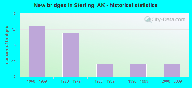
- New bridges - historical statistics
- 81960-1969
- 71970-1979
- 21980-1989
- 21990-1999
- 22000-2009


- Bridge Condition - Deck
- 21.4%Very good
- 21.4%Good
- 50.0%Satisfactory
- 7.1%Fair

- Bridge Condition - Superstructure
- 7.1%Very good
- 50.0%Good
- 28.6%Satisfactory
- 14.3%Fair

- Bridge Condition - Substructure
- 21.4%Very good
- 42.9%Satisfactory
- 35.7%Fair

- Bridge Condition - Channel
- 55.0%Very good
- 15.0%Good
- 25.0%Satisfactory
- 5.0%Imminent failure

- Bridge Condition - Culverts
- 28.6%Very good
- 14.3%Good
- 28.6%Satisfactory
- 28.6%Fair
Find on map >> Show street view
Structure Number: 23, Location: MILE POINT 14.8 (Lat: 60.477758, Lng: -145.403178), Route carried "on" structure: State highway 851, Year Built: 1968, Status: Open, Structure Length: 6.14m (20.14ft), Average Daily Traffic: 170 (year 2020), Truck Traffic: 8%, Average Future Daily Traffic: 270 (year 2039), Design Load: HS 20, Features Intersected: SHERIDAN GLACIER NO. 3, Facility Carried by Structure: COPPER RIVER HWY
Minimum Vertical Clearance: 3.35m (10.99ft), Kilometerpoint: 23.813, Lanes on structure: 2, Owner: State Highway Agency, Approaching Roadway Width: 8.8m (28.9ft), Material/Design: Prestressed concrete, Design/Construction: Tee Beam, Number Of Spans In Main Unit: 5, Length of Maximum Span: 12.2m (40.0ft), Curb-To-Curb Width: 8.5m (27.9ft), Out-to-Out Width: 9.3m (30.5ft)
Condition: Deck: Satisfactory, Superstructure: Satisfactory, Substructure: Fair, Channel: Very good, Operating Rating: 90.9 metric tons, Method Used To Determine Operating Rating: Load Factor (LF), Inventory Rating: 41.9 metric tons, Method Used To Determine Inventory Rating: Load Factor (LF), Structural Evaluation: Somewhat better than minimum adequacy, Deck Geometry: Equal to present minimum criteria, Waterway Adequacy: Equal to present minimum criteria, Approach Roadway Alignment: Equal to present desirable criteria, Designated Inspection Frequency: Every 24 months, Inspection Date: August 2020, Deck Structure Type: Concrete Precast Panels, Wearing Surface/Protective System: Wearing Surface: Monolithic Concrete
Find on map >> Show street view
Structure Number: 24, Location: MILE POINT 21.8 (Lat: 61.626958, Lng: -149.800911), Route carried "on" structure: Interstate A41, Year Built: 2004, Status: Open, Structure Length: 7.65m (25.10ft), Average Daily Traffic: 4,700 (year 2020), Truck Traffic: 16%, Average Future Daily Traffic: 7,090 (year 2039), Design Load: HS 25 or greater, Features Intersected: LITTLE SUSITNA RIVER, Facility Carried by Structure: PARKS HIGHWAY
Minimum Vertical Clearance: 5.42m (17.78ft), Kilometerpoint: 35.084, Lanes on structure: 2, Base Highway Network: Yes, Owner: State Highway Agency, Approaching Roadway Width: 12.2m (40.0ft), Material/Design: Prestressed concrete, Design/Construction: Tee Beam, Number Of Spans In Main Unit: 2, Length of Maximum Span: 37.5m (123.0ft), Curb or Sidewalk Widths: Left: 3.6m (11.8ft), Right: 0.0m, Curb-To-Curb Width: 12.0m (39.4ft), Out-to-Out Width: 16.8m (55.1ft)
Condition: Deck: Good, Superstructure: Very good, Substructure: Very good, Channel: Very good, Operating Rating: 87.7 metric tons, Method Used To Determine Operating Rating: Load Factor (LF), Inventory Rating: 40.4 metric tons, Method Used To Determine Inventory Rating: Load Factor (LF), Structural Evaluation: Equal to present desirable criteria, Deck Geometry: Somewhat better than minimum adequacy, Waterway Adequacy: Equal to present desirable criteria, Approach Roadway Alignment: Equal to present minimum criteria, Designated Inspection Frequency: Every 24 months, Inspection Date: June 2020, Deck Structure Type: Other, Wearing Surface/Protective System: Wearing Surface: Bituminous, Membrane: Preformed Fabric, Deck Protection: Epoxy Coated Reinforcing
Find on map >> Show street view
Structure Number: 26, Location: MILE POINT 150.8 (Lat: 63.145078, Lng: -149.421344), Route carried "on" structure: Interstate A43, Year Built: 1967, Status: Open, Structure Length: 4.35m (14.27ft), Average Daily Traffic: 900 (year 2020), Truck Traffic: 37%, Average Future Daily Traffic: 1,130 (year 2039), Design Load: HS 20, Features Intersected: EAST FORK CHULITNA RIVER, Facility Carried by Structure: PARKS HIGHWAY
Minimum Vertical Clearance: 5.42m (17.78ft), Kilometerpoint: 242.637, Lanes on structure: 2, Base Highway Network: Yes, Owner: State Highway Agency, Approaching Roadway Width: 12.2m (40.0ft), Material/Design: Steel, Design/Construction: Stringer/Multi-beam, Number Of Spans In Main Unit: 3, Length of Maximum Span: 21.3m (69.9ft), Curb or Sidewalk Widths: Left: 0.5m (1.6ft), Right: 0.5m (1.6ft), Curb-To-Curb Width: 9.1m (29.9ft), Out-to-Out Width: 10.1m (33.1ft)
Condition: Deck: Satisfactory, Superstructure: Satisfactory, Substructure: Fair, Channel: Very good, Operating Rating: 68.2 metric tons, Method Used To Determine Operating Rating: Load Factor (LF), Inventory Rating: 29.6 metric tons, Method Used To Determine Inventory Rating: Load Factor (LF), Structural Evaluation: Somewhat better than minimum adequacy, Deck Geometry: Equal to present minimum criteria, Waterway Adequacy: Superior to present desirable criteria, Approach Roadway Alignment: Equal to present minimum criteria, Designated Inspection Frequency: Every 24 months, Inspection Date: June 2020, Deck Structure Type: Concrete Cast-file-Place, Wearing Surface/Protective System: Wearing Surface: Bituminous
Find on map >> Show street view
Structure Number: 27, Location: MILE POINT 11.8 (Lat: 64.885461, Lng: -147.249819), Route carried "on" structure: State highway 650, Year Built: 1965, Status: Open, Structure Length: 3.75m (12.30ft), Average Daily Traffic: 1,850 (year 2020), Truck Traffic: 9%, Average Future Daily Traffic: 2,150 (year 2039), Design Load: HS 20, Features Intersected: LITTLE CHENA RIVER, Facility Carried by Structure: CHENA HOT SPR RD
Minimum Vertical Clearance: 5.03m (16.50ft), Kilometerpoint: 18.986, Lanes on structure: 2, Owner: State Highway Agency, Approaching Roadway Width: 9.1m (29.9ft), Material/Design: Steel, Design/Construction: Stringer/Multi-beam, Number Of Spans In Main Unit: 3, Length of Maximum Span: 15.2m (49.9ft), Curb or Sidewalk Widths: Left: 0.5m (1.6ft), Right: 0.5m (1.6ft), Curb-To-Curb Width: 9.1m (29.9ft), Out-to-Out Width: 10.7m (35.1ft)
Condition: Deck: Satisfactory, Superstructure: Good, Substructure: Fair, Channel: Satisfactory, Operating Rating: 87.1 metric tons, Method Used To Determine Operating Rating: Load Factor (LF), Inventory Rating: 35.3 metric tons, Method Used To Determine Inventory Rating: Load Factor (LF), Structural Evaluation: Somewhat better than minimum adequacy, Deck Geometry: Somewhat better than minimum adequacy, Waterway Adequacy: Equal to present minimum criteria, Approach Roadway Alignment: Equal to present desirable criteria, Designated Inspection Frequency: Every 24 months, Inspection Date: August 2020, Deck Structure Type: Concrete Cast-file-Place, Wearing Surface/Protective System: Wearing Surface: Monolithic Concrete
Find on map >> Show street view
Structure Number: 29, Location: MILE POINT 28.8 (Lat: 57.617622, Lng: -152.260672), Route carried "on" structure: State highway 391, Year Built: 1974, Status: Open, Structure Length: 1.92m (6.30ft), Average Daily Traffic: 166 (year 2018), Truck Traffic: 11%, Average Future Daily Traffic: 200 (year 2035), Design Load: HS 20, Features Intersected: EAST FORK TWIN CREEK, Facility Carried by Structure: CHINIAK HIGHWAY
Minimum Vertical Clearance: 30+ m (98+ ft), Kilometerpoint: 46.312, Lanes on structure: 2, Owner: State Highway Agency, Approaching Roadway Width: 8.5m (27.9ft), Material/Design: Prestressed concrete, Design/Construction: Tee Beam, Number Of Spans In Main Unit: 2, Length of Maximum Span: 9.4m (30.8ft), Curb-To-Curb Width: 7.3m (24.0ft), Out-to-Out Width: 8.5m (27.9ft)
Condition: Deck: Good, Superstructure: Good, Substructure: Satisfactory, Channel: Satisfactory, Operating Rating: 84.6 metric tons, Method Used To Determine Operating Rating: Load Factor (LF), Inventory Rating: 38.6 metric tons, Method Used To Determine Inventory Rating: Load Factor (LF), Structural Evaluation: Equal to present minimum criteria, Deck Geometry: Somewhat better than minimum adequacy, Waterway Adequacy: Equal to present desirable criteria, Approach Roadway Alignment: Equal to present minimum criteria, Designated Inspection Frequency: Every 24 months, Inspection Date: September 2020, Deck Structure Type: Other, Wearing Surface/Protective System: Wearing Surface: Bituminous, Membrane: Preformed Fabric
Find on map >> Show street view
Structure Number: 32, Location: MILE POINT 2.6 (Lat: 64.486042, Lng: -165.292236), Route carried "on" structure: State highway 130, Year Built: 1967, Status: Open, Structure Length: 8.63m (28.31ft), Average Daily Traffic: 430 (year 2020), Truck Traffic: 8%, Average Future Daily Traffic: 550 (year 2039), Design Load: HS 20+Mod, Features Intersected: NOME RIVER, Facility Carried by Structure: IRR:NOME-COUNCIL
Minimum Vertical Clearance: 30+ m (98+ ft), Kilometerpoint: 4.239, Lanes on structure: 2, Owner: State Highway Agency, Approaching Roadway Width: 11.0m (36.1ft), Material/Design: Steel continuous, Design/Construction: Stringer/Multi-beam, Number Of Spans In Main Unit: 3, Length of Maximum Span: 42.7m (140.1ft), Curb-To-Curb Width: 8.5m (27.9ft), Out-to-Out Width: 9.0m (29.5ft)
Condition: Deck: Satisfactory, Superstructure: Fair, Substructure: Fair, Channel: Very good, Operating Rating: 65.9 metric tons, Method Used To Determine Operating Rating: Load Factor (LF), Inventory Rating: 30.4 metric tons, Method Used To Determine Inventory Rating: Load Factor (LF), Structural Evaluation: Somewhat better than minimum adequacy, Deck Geometry: Somewhat better than minimum adequacy, Waterway Adequacy: Equal to present desirable criteria, Approach Roadway Alignment: Equal to present desirable criteria, Designated Inspection Frequency: Every 24 months, Inspection Date: August 2020, Deck Structure Type: Concrete Cast-file-Place, Wearing Surface/Protective System: Wearing Surface: Monolithic Concrete
Find on map >> Show street view
Structure Number: 34, Location: MILE POINT 36.5 (Lat: 60.518472, Lng: -144.850989), Route carried "on" structure: State highway 851, Year Built: 1977, Status: Closed, Structure Length: 7.35m (24.11ft), Average Daily Traffic: 94 (year 2011), Truck Traffic: 1%, Average Future Daily Traffic: 150 (year 2030), Design Load: HS 20, Features Intersected: COPPER DELTA, Facility Carried by Structure: COPPER RIVER HWY
Minimum Vertical Clearance: 6.10m (20.01ft), Kilometerpoint: 58.685, Lanes on structure: 2, Owner: State Highway Agency, Approaching Roadway Width: 8.8m (28.9ft), Material/Design: Prestressed concrete, Design/Construction: Tee Beam, Number Of Spans In Main Unit: 3, Length of Maximum Span: 24.4m (80.1ft), Curb-To-Curb Width: 8.5m (27.9ft), Out-to-Out Width: 8.8m (28.9ft)
Condition: Deck: Good, Superstructure: Good, Substructure: Very good, Channel: Imminent failure, Operating Rating: 74.5 metric tons, Method Used To Determine Operating Rating: Load Factor (LF), Inventory Rating: 34.3 metric tons, Method Used To Determine Inventory Rating: Load Factor (LF), Structural Evaluation: Better than present minimum criteria, Deck Geometry: Better than present minimum criteria, Approach Roadway Alignment: Equal to present desirable criteria, Designated Inspection Frequency: Every 24 months, Inspection Date: August 2010, Deck Structure Type: Concrete Precast Panels, Wearing Surface/Protective System: Wearing Surface: Monolithic Concrete
Find on map >> Show street view
Structure Number: 35, Location: MILE POINT 8.1 (Lat: 60.516939, Lng: -145.580128), Route carried "on" structure: State highway 851, Year Built: 1966, Status: Open, Structure Length: 4.93m (16.17ft), Average Daily Traffic: 520 (year 2020), Truck Traffic: 17%, Average Future Daily Traffic: 630 (year 2039), Design Load: HS 20+Mod, Features Intersected: SCOTT GLACIER NO 3, Facility Carried by Structure: COPPER RIVER HWY
Minimum Vertical Clearance: 6.10m (20.01ft), Kilometerpoint: 13.045, Lanes on structure: 2, Owner: State Highway Agency, Approaching Roadway Width: 8.2m (26.9ft), Material/Design: Steel, Design/Construction: Stringer/Multi-beam, Number Of Spans In Main Unit: 3, Length of Maximum Span: 18.6m (61.0ft), Curb-To-Curb Width: 8.5m (27.9ft), Out-to-Out Width: 9.0m (29.5ft)
Condition: Deck: Satisfactory, Superstructure: Good, Substructure: Very good, Channel: Very good, Operating Rating: 63.0 metric tons, Method Used To Determine Operating Rating: Load Factor (LF), Inventory Rating: 29.0 metric tons, Method Used To Determine Inventory Rating: Load Factor (LF), Structural Evaluation: Better than present minimum criteria, Deck Geometry: Somewhat better than minimum adequacy, Waterway Adequacy: Meets minimum limits, Approach Roadway Alignment: Equal to present desirable criteria, Designated Inspection Frequency: Every 24 months, Inspection Date: August 2020, Deck Structure Type: Concrete Cast-file-Place, Wearing Surface/Protective System: Wearing Surface: Monolithic Concrete
Find on map >> Show street view
Structure Number: 36, Location: MILE POINT 5.0 (Lat: 61.534281, Lng: -149.827072), Route carried "on" structure: State highway 511, Year Built: 1973, Status: Open, Structure Length: 1.15m (3.77ft), Average Daily Traffic: 1,610 (year 2020), Truck Traffic: 8%, Average Future Daily Traffic: 1,880 (year 2039), Design Load: HS 20, Features Intersected: FISH CREEK, Facility Carried by Structure: BIG LAKE ROAD
Minimum Vertical Clearance: 30+ m (98+ ft), Kilometerpoint: 8.060, Lanes on structure: 2, Owner: State Highway Agency, Approaching Roadway Width: 10.4m (34.1ft), Material/Design: Prestressed concrete, Design/Construction: Tee Beam, Number Of Spans In Main Unit: 1, Length of Maximum Span: 11.0m (36.1ft), Curb-To-Curb Width: 10.4m (34.1ft), Out-to-Out Width: 11.1m (36.4ft)
Condition: Deck: Very good, Superstructure: Good, Substructure: Satisfactory, Channel: Very good, Operating Rating: 44.7 metric tons, Method Used To Determine Operating Rating: Load Factor (LF), Inventory Rating: 24.9 metric tons, Method Used To Determine Inventory Rating: Load Factor (LF), Structural Evaluation: Equal to present minimum criteria, Deck Geometry: Equal to present minimum criteria, Waterway Adequacy: Equal to present desirable criteria, Approach Roadway Alignment: Better than present minimum criteria, Designated Inspection Frequency: Every 24 months, Inspection Date: June 2020, Deck Structure Type: Other, Wearing Surface/Protective System: Wearing Surface: Bituminous, Membrane: Preformed Fabric
Find on map >> Show street view
Structure Number: 38, Location: MILE POINT 130.0 (Lat: 64.492200, Lng: -141.192000), Route carried "on" structure: State highway 786, Year Built: 1988, Status: Open, Structure Length: 2.44m (8.01ft), Average Daily Traffic: 20 (year 2020), Truck Traffic: 28%, Average Future Daily Traffic: 30 (year 2039), Design Load: HS 20, Features Intersected: KING SOLOMON CREEK, Facility Carried by Structure: TAYLOR HIGHWAY
Minimum Vertical Clearance: 30+ m (98+ ft), Kilometerpoint: 209.275, Lanes on structure: 2, Owner: State Highway Agency, Approaching Roadway Width: 8.5m (27.9ft), Material/Design: Prestressed concrete, Design/Construction: Tee Beam, Number Of Spans In Main Unit: 1, Length of Maximum Span: 24.1m (79.1ft), Curb-To-Curb Width: 8.6m (28.2ft), Out-to-Out Width: 8.9m (29.2ft)
Condition: Deck: Very good, Superstructure: Good, Substructure: Satisfactory, Channel: Satisfactory, Operating Rating: 86.9 metric tons, Method Used To Determine Operating Rating: Load Factor (LF), Inventory Rating: 40.0 metric tons, Method Used To Determine Inventory Rating: Load Factor (LF), Structural Evaluation: Equal to present minimum criteria, Deck Geometry: Better than present minimum criteria, Waterway Adequacy: Equal to present desirable criteria, Approach Roadway Alignment: Better than present minimum criteria, Designated Inspection Frequency: Every 24 months, Inspection Date: July 2021, Deck Structure Type: Other, Wearing Surface/Protective System: Wearing Surface: Monolithic Concrete
Find on map >> Show street view
Structure Number: 39, Location: MILE POINT 3.3 (Lat: 64.844281, Lng: -147.721661), Route carried "on" structure: State highway 663, Year Built: 1960, Status: Open, Structure Length: 7.40m (24.28ft), Average Daily Traffic: 7,390 (year 2020), Truck Traffic: 4%, Average Future Daily Traffic: 8,480 (year 2039), Design Load: HS 20, Features Intersected: CHENA RIVER (CUSHMAN), Facility Carried by Structure: ILLINOIS/CUSHMAN
Minimum Vertical Clearance: 30+ m (98+ ft), Kilometerpoint: 5.272, Lanes on structure: 3, Owner: State Highway Agency, Approaching Roadway Width: 14.6m (47.9ft), Material/Design: Steel, Design/Construction: Stringer/Multi-beam, Number Of Spans In Main Unit: 3, Length of Maximum Span: 24.4m (80.1ft), Curb or Sidewalk Widths: Left: 1.6m (5.2ft), Right: 1.6m (5.2ft), Curb-To-Curb Width: 14.6m (47.9ft), Out-to-Out Width: 18.3m (60.0ft)
Condition: Deck: Fair, Superstructure: Satisfactory, Substructure: Satisfactory, Channel: Good, Operating Rating: 47.3 metric tons, Method Used To Determine Operating Rating: Load Factor (LF), Inventory Rating: 21.8 metric tons, Method Used To Determine Inventory Rating: Load Factor (LF), Structural Evaluation: Somewhat better than minimum adequacy, Deck Geometry: Somewhat better than minimum adequacy, Waterway Adequacy: Better than present minimum criteria, Approach Roadway Alignment: Somewhat better than minimum adequacy, Designated Inspection Frequency: Every 24 months, Underwater Inspection Frequency: Every 60 months, Inspection Date: August 2020, Underwater Inspection Date: October 2019, Deck Structure Type: Concrete Cast-file-Place, Wearing Surface/Protective System: Wearing Surface: Monolithic Concrete
Find on map >> Show street view
Structure Number: 407, Location: MILE POINT 9.7 (Lat: 60.507458, Lng: -145.537272), Route carried "on" structure: State highway 851, Year Built: 1966, Status: Open, Structure Length: 5.54m (18.18ft), Average Daily Traffic: 520 (year 2020), Truck Traffic: 17%, Average Future Daily Traffic: 630 (year 2039), Design Load: HS 20+Mod, Features Intersected: SCOTT GLACIER NO 7, Facility Carried by Structure: COPPER RIVER HWY
Minimum Vertical Clearance: 6.10m (20.01ft), Kilometerpoint: 15.609, Lanes on structure: 2, Owner: State Highway Agency, Approaching Roadway Width: 7.9m (25.9ft), Material/Design: Steel, Design/Construction: Stringer/Multi-beam, Number Of Spans In Main Unit: 3, Length of Maximum Span: 18.3m (60.0ft), Curb-To-Curb Width: 8.6m (28.2ft), Out-to-Out Width: 9.0m (29.5ft)
Condition: Deck: Satisfactory, Superstructure: Satisfactory, Substructure: Satisfactory, Channel: Good, Operating Rating: 63.0 metric tons, Method Used To Determine Operating Rating: Load Factor (LF), Inventory Rating: 29.0 metric tons, Method Used To Determine Inventory Rating: Load Factor (LF), Structural Evaluation: Equal to present minimum criteria, Deck Geometry: Somewhat better than minimum adequacy, Waterway Adequacy: Equal to present minimum criteria, Approach Roadway Alignment: Equal to present desirable criteria, Designated Inspection Frequency: Every 24 months, Inspection Date: August 2020, Deck Structure Type: Concrete Cast-file-Place, Wearing Surface/Protective System: Wearing Surface: Monolithic Concrete
Find on map >> Show street view
Structure Number: 501, Location: MILE POINT 2.0 (Lat: 62.638708, Lng: -141.028947), Route carried "on" structure: Interstate A11, Year Built: 1995, Status: Open, Structure Length: 3.83m (12.57ft), Average Daily Traffic: 220 (year 2020), Truck Traffic: 30%, Average Future Daily Traffic: 290 (year 2039), Design Load: HS 25 or greater, Features Intersected: SCOTTIE CREEK, Facility Carried by Structure: ALASKA HIGHWAY
Minimum Vertical Clearance: 4.72m (15.49ft), Kilometerpoint: 3.140, Lanes on structure: 2, Base Highway Network: Yes, Owner: State Highway Agency, Approaching Roadway Width: 11.0m (36.1ft), Material/Design: Prestressed concrete, Design/Construction: Tee Beam, Number Of Spans In Main Unit: 1, Length of Maximum Span: 37.8m (124.0ft), Curb-To-Curb Width: 11.0m (36.1ft), Out-to-Out Width: 11.9m (39.0ft)
Condition: Deck: Very good, Superstructure: Good, Substructure: Satisfactory, Channel: Very good, Operating Rating: 80.8 metric tons, Method Used To Determine Operating Rating: Load Factor (LF), Inventory Rating: 39.2 metric tons, Method Used To Determine Inventory Rating: Load Factor (LF), Structural Evaluation: Equal to present minimum criteria, Deck Geometry: Equal to present desirable criteria, Waterway Adequacy: Equal to present desirable criteria, Approach Roadway Alignment: Superior to present desirable criteria, Designated Inspection Frequency: Every 24 months, Inspection Date: July 2020, Deck Structure Type: Other, Wearing Surface/Protective System: Wearing Surface: Bituminous, Membrane: Preformed Fabric, Deck Protection: Epoxy Coated Reinforcing
Find on map >> Show street view
Structure Number: 978, Location: MILE POINT 11.1 (Lat: 60.490000, Lng: -150.860556), Route carried "on" structure: Spur State highway NSP00, Year Built: 1969, Status: Open, Structure Length: 1.58m (5.18ft), Average Daily Traffic: 1,830 (year 2020), Truck Traffic: 6%, Average Future Daily Traffic: 3,220 (year 2039), Features Intersected: FUNNY RIVER, Facility Carried by Structure: FUNNY RIVER ROAD
Minimum Vertical Clearance: 30+ m (98+ ft), Kilometerpoint: 17.857, Lanes on structure: 2, Owner: State Highway Agency, Approaching Roadway Width: 7.2m (23.6ft), Material/Design: Steel, Design/Construction: Stringer/Multi-beam, Number Of Spans In Main Unit: 1, Length of Maximum Span: 15.2m (49.9ft), Curb-To-Curb Width: 7.2m (23.6ft), Out-to-Out Width: 7.9m (25.9ft)
Condition: Deck: Satisfactory, Superstructure: Fair, Substructure: Fair, Channel: Satisfactory, Operating Rating: 73.1 metric tons, Method Used To Determine Operating Rating: Load Factor (LF), Inventory Rating: 24.9 metric tons, Method Used To Determine Inventory Rating: Load Factor (LF), Structural Evaluation: Somewhat better than minimum adequacy, Deck Geometry: High priority of corrective action, Waterway Adequacy: Better than present minimum criteria, Approach Roadway Alignment: Equal to present minimum criteria, Designated Inspection Frequency: Every 24 months, Inspection Date: August 2021, Deck Structure Type: Wood or Timber, Wearing Surface/Protective System: Wearing Surface: Wood or Timber
Find on map >> Show street view
Structure Number: 4064, Location: MILE POINT 4.9 (Lat: 58.345700, Lng: -134.501000), Route carried "on" structure: State highway 93, Year Built: 1973, Status: Open, Structure Length: 0.95m (3.12ft), Average Daily Traffic: 17,000 (year 2020), Truck Traffic: 5%, Average Future Daily Traffic: 21,500 (year 2039), Design Load: H 20, Features Intersected: VANDERBILT CREEK, Facility Carried by Structure: EGAN DRIVE
Minimum Vertical Clearance: 5.48m (17.98ft), Kilometerpoint: 7.894, Lanes on structure: 5, Base Highway Network: Yes, Owner: State Highway Agency, Approaching Roadway Width: 24.4m (80.1ft), Skew: 20 degrees, Material/Design: Steel, Design/Construction: Culvert, Number Of Spans In Main Unit: 2, Length of Maximum Span: 4.0m (13.1ft)
Condition: Channel: Very good, Culverts: Very good, Structural Evaluation: Equal to present desirable criteria, Waterway Adequacy: Equal to present desirable criteria, Approach Roadway Alignment: Equal to present desirable criteria, Designated Inspection Frequency: Every 24 months, Inspection Date: June 2021
Find on map >> Show street view
Structure Number: 4065, Location: MILE POINT 4.6 (Lat: 58.295400, Lng: -134.545600), Route carried "on" structure: State highway 953, Year Built: 1985, Status: Open, Structure Length: 0.82m (2.69ft), Average Daily Traffic: 240 (year 2020), Truck Traffic: 21%, Average Future Daily Traffic: 310 (year 2039), Design Load: H 15, Features Intersected: SOUTH FORK FISH CREEK, Facility Carried by Structure: FISH CREEK ROAD
Minimum Vertical Clearance: 30+ m (98+ ft), Kilometerpoint: 7.326, Lanes on structure: 2, Owner: State Highway Agency, Approaching Roadway Width: 9.8m (32.2ft), Material/Design: Steel, Design/Construction: Culvert, Number Of Spans In Main Unit: 2, Length of Maximum Span: 3.5m (11.5ft)
Condition: Channel: Very good, Culverts: Good, Operating Rating: 63.0 metric tons, Method Used To Determine Operating Rating: Load Factor (LF), Inventory Rating: 57.8 metric tons, Method Used To Determine Inventory Rating: Load Factor (LF), Structural Evaluation: Better than present minimum criteria, Waterway Adequacy: Equal to present desirable criteria, Approach Roadway Alignment: Equal to present desirable criteria, Designated Inspection Frequency: Every 24 months, Inspection Date: June 2021
Find on map >> Show street view
Structure Number: 4066, Location: MILE POINT 0.1 (Lat: 61.173889, Lng: -149.981111), Route carried "on" structure: Ramp State highway , Year Built: 2000, Status: Open, Structure Length: 1.53m (5.02ft), Average Daily Traffic: 1,310 (year 2020), Truck Traffic: 6%, Average Future Daily Traffic: 2,060 (year 2039), Design Load: HS 20, Features Intersected: AIA PEDESTRIAN U.C., Facility Carried by Structure: ANCH INTL AIRPORT
Minimum Vertical Clearance: 3.61m (11.84ft), Kilometerpoint: 0.161, Lanes on structure: 2, Base Highway Network: Yes, Owner: State Agenciy, Approaching Roadway Width: 17.1m (56.1ft), Skew: 5 degrees, Material/Design: Concrete, Design/Construction: Culvert, Number Of Spans In Main Unit: 1, Length of Maximum Span: 9.2m (30.2ft), Curb-To-Curb Width: 12.2m (40.0ft), Out-to-Out Width: 48.8m (160.1ft)
Condition: Culverts: Very good, Operating Rating: 70.9 metric tons, Method Used To Determine Operating Rating: Assigned rating based on Load Factor Design (LFD) reported in metric tons, Inventory Rating: 32.7 metric tons, Method Used To Determine Inventory Rating: Assigned rating based on Load Factor Design (LFD) reported in metric tons, Structural Evaluation: Equal to present desirable criteria, Deck Geometry: High priority of corrective action, Approach Roadway Alignment: Superior to present desirable criteria, Designated Inspection Frequency: Every 24 months, Inspection Date: August 2021, Deck Structure Type: Concrete Cast-file-Place, Wearing Surface/Protective System: Wearing Surface: Bituminous, Membrane: Preformed Fabric
Find on map >> Show street view
Structure Number: 4067, Location: MILE POINT 8.3 (Lat: 58.366389, Lng: -134.577500), Route carried "on" structure: State highway 953, Year Built: 1971, Status: Open, Structure Length: 0.67m (2.20ft), Average Daily Traffic: 21,700 (year 2020), Truck Traffic: 8%, Average Future Daily Traffic: 34,100 (year 2039), Features Intersected: JORDAN CREEK (EGAN DR), Facility Carried by Structure: EGAN DRIVE
Minimum Vertical Clearance: 5.48m (17.98ft), Kilometerpoint: 13.388, Lanes on structure: 4, Base Highway Network: Yes, Owner: State Highway Agency, Approaching Roadway Width: 21.9m (71.9ft), Skew: 23 degrees, Material/Design: Steel, Design/Construction: Culvert, Number Of Spans In Main Unit: 2, Length of Maximum Span: 2.8m (9.2ft)
Condition: Channel: Very good, Culverts: Fair, Structural Evaluation: Somewhat better than minimum adequacy, Waterway Adequacy: Equal to present minimum criteria, Approach Roadway Alignment: Equal to present desirable criteria, Designated Inspection Frequency: Every 24 months, Inspection Date: June 2021
Find on map >> Show street view
Structure Number: 4068, Location: MILE POINT 4.3 (Lat: 61.599433, Lng: -149.251183), Route carried "on" structure: State highway , Year Built: 1998, Status: Open, Structure Length: 0.73m (2.40ft), Average Daily Traffic: 9,190 (year 2020), Truck Traffic: 5%, Average Future Daily Traffic: 10,700 (year 2039), Design Load: H 20, Features Intersected: WASILLA CREEK, Facility Carried by Structure: PALMER/WASILLA HWY
Minimum Vertical Clearance: 30+ m (98+ ft), Kilometerpoint: 6.896, Lanes on structure: 2, Base Highway Network: Yes, Owner: State Highway Agency, Approaching Roadway Width: 12.2m (40.0ft), Material/Design: Steel, Design/Construction: Culvert, Number Of Spans In Main Unit: 2, Length of Maximum Span: 3.0m (9.8ft)
Condition: Channel: Good, Culverts: Satisfactory, Structural Evaluation: Equal to present minimum criteria, Waterway Adequacy: Better than present minimum criteria, Approach Roadway Alignment: Equal to present desirable criteria, Designated Inspection Frequency: Every 24 months, Inspection Date: June 2020
Find on map >> Show street view
Structure Number: 4069, Location: MILE POINT 19.4 (Lat: 57.590000, Lng: -152.435000), Route carried "on" structure: State highway 391, Year Built: 1974, Status: Open, Structure Length: 0.82m (2.69ft), Average Daily Traffic: 190 (year 2020), Truck Traffic: 11%, Average Future Daily Traffic: 370 (year 2039), Design Load: H 20, Features Intersected: FRANK CREEK, Facility Carried by Structure: CHINIAK HIGHWAY
Minimum Vertical Clearance: 30+ m (98+ ft), Kilometerpoint: 31.199, Lanes on structure: 2, Owner: State Highway Agency, Approaching Roadway Width: 7.3m (24.0ft), Material/Design: Steel, Design/Construction: Culvert, Number Of Spans In Main Unit: 3, Length of Maximum Span: 2.1m (6.9ft)
Condition: Channel: Very good, Culverts: Satisfactory, Operating Rating: 73.5 metric tons, Method Used To Determine Operating Rating: Load Factor (LF), Inventory Rating: 70.2 metric tons, Method Used To Determine Inventory Rating: Load Factor (LF), Structural Evaluation: Equal to present minimum criteria, Waterway Adequacy: Equal to present desirable criteria, Approach Roadway Alignment: Equal to present desirable criteria, Designated Inspection Frequency: Every 24 months, Inspection Date: September 2020
Find on map >> Show street view
Structure Number: 4071, Location: MILE POINT 22.2 (Lat: 59.480853, Lng: -139.169394), Route carried "on" structure: State highway 942, Year Built: 1976, Status: Open, Structure Length: 1.67m (5.48ft), Average Daily Traffic: 40 (year 2020), Truck Traffic: 33%, Average Future Daily Traffic: 50 (year 2039), Design Load: H 20, Features Intersected: SOCKEYE CREEK, Facility Carried by Structure: IRR:DANGEROUS RIV
Minimum Vertical Clearance: 30+ m (98+ ft), Kilometerpoint: 35.682, Lanes on structure: 2, Owner: State Highway Agency, Approaching Roadway Width: 7.6m (24.9ft), Skew: 3 degrees, Material/Design: Steel, Design/Construction: Culvert, Number Of Spans In Main Unit: 4, Length of Maximum Span: 3.0m (9.8ft)
Condition: Channel: Satisfactory, Culverts: Fair, Structural Evaluation: Somewhat better than minimum adequacy, Waterway Adequacy: Somewhat better than minimum adequacy, Approach Roadway Alignment: Equal to present desirable criteria, Designated Inspection Frequency: Every 24 months, Inspection Date: June 2020