Bridge Statistics for Sterling, Nebraska (NE)
Condition, Traffic, Stress, Structural Evaluation, Project Costs
- National Bridge Inventory (NBI) Statistics
- 28Number of bridges
- 249ft / 76.3mTotal length
- 17,150Total average daily traffic
- 2,965Total average daily truck traffic
- 24,529Total future (year 2033) average daily traffic
- National Bridge Inventory (NBI) Registered Bridges for Sterling
- No street view available for this location
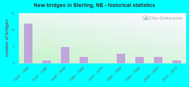
- New bridges - historical statistics
- 121930-1939
- 11940-1949
- 51950-1959
- 21960-1969
- 31980-1989
- 21990-1999
- 22000-2009
- 12010-2019

- Reconstructed bridges - Historical Statistics
- 11950-1959
- 01960-1969
- 01970-1979
- 01980-1989
- 01990-1999
- 32000-2009

- Bridge Condition - Deck
- 5.3%Excellent
- 15.8%Very good
- 21.1%Good
- 36.8%Satisfactory
- 5.3%Fair
- 10.5%Poor
- 5.3%Failed

- Bridge Condition - Superstructure
- 5.3%Excellent
- 26.3%Very good
- 5.3%Good
- 15.8%Satisfactory
- 26.3%Fair
- 21.1%Poor

- Bridge Condition - Substructure
- 5.3%Excellent
- 15.8%Very good
- 15.8%Good
- 10.5%Satisfactory
- 31.6%Fair
- 15.8%Poor
- 5.3%Serious

- Bridge Condition - Channel
- 25.0%Very good
- 28.6%Good
- 21.4%Satisfactory
- 10.7%Fair
- 10.7%Poor
- 3.6%Serious

- Bridge Condition - Culverts
- 11.1%Excellent
- 11.1%Very good
- 33.3%Good
- 44.4%Satisfactory
Find on map >> Show street view
Structure Number: C004900615, Location: 2.5N 1.5W OF STERLING (Lat: 40.494100, Lng: -96.407400), Route carried "on" structure: County highway 6, Year Built: 1935, Status: Posted for load, Structure Length: 1.52m (4.99ft), Average Daily Traffic: 45 (year 2003), Average Future Daily Traffic: 76 (year 2033), Features Intersected: NORTH FORK BIG NEMAHA TR
Minimum Vertical Clearance: 30+ m (98+ ft), Kilometerpoint: 0.000, Lanes on structure: 2, Owner: County Highway Agency, Approaching Roadway Width: 8.5m (27.9ft), Material/Design: Steel, Design/Construction: Culvert, Number Of Spans In Main Unit: 3, Length of Maximum Span: 9.4m (30.8ft)
Condition: Channel: Good, Culverts: Excellent, Operating Rating: 14.0 metric tons, Method Used To Determine Operating Rating: Allowable Stress (AS), Inventory Rating: 8.0 metric tons, Method Used To Determine Inventory Rating: Allowable Stress (AS), Structural Evaluation: High priority of replacement, Waterway Adequacy: Equal to present desirable criteria, Approach Roadway Alignment: Equal to present desirable criteria, Bridge Posting: Required (Relationship of Operating Rating to Maximum Legal Load: > 39.9% below), Length Of Structure Improvement: 1.55m (5.09ft), Designated Inspection Frequency: Every 24 months, Inspection Date: September 2021
Find on map >> Show street view
Structure Number: C004900625, Location: 2.5E 2.5N OF STERLING (Lat: 40.493900, Lng: -96.333500), Route carried "on" structure: County highway 6, Year Built: 1940, Status: Posted for load, Structure Length: 1.22m (4.00ft), Average Daily Traffic: 35 (year 2003), Average Future Daily Traffic: 59 (year 2033), Features Intersected: SANDERS CREEK, Facility Carried by Structure: COUNTY HIGHWAY
Minimum Vertical Clearance: 30+ m (98+ ft), Kilometerpoint: 0.000, Lanes on structure: 1, Owner: County Highway Agency, Approaching Roadway Width: 5.5m (18.0ft), Material/Design: Steel, Design/Construction: Stringer/Multi-beam, Number Of Spans In Main Unit: 1, Length of Maximum Span: 11.6m (38.1ft), Curb-To-Curb Width: 4.8m (15.7ft), Out-to-Out Width: 4.8m (15.7ft)
Condition: Deck: Satisfactory, Superstructure: Satisfactory, Substructure: Fair, Channel: Satisfactory, Operating Rating: 28.0 metric tons, Method Used To Determine Operating Rating: Load Factor (LF), Inventory Rating: 17.0 metric tons, Method Used To Determine Inventory Rating: Load Factor (LF), Structural Evaluation: Somewhat better than minimum adequacy, Deck Geometry: Equal to present desirable criteria, Waterway Adequacy: Equal to present desirable criteria, Approach Roadway Alignment: Equal to present minimum criteria, Bridge Posting: Required (Relationship of Operating Rating to Maximum Legal Load: 30.0 - 39.9% below), Length Of Structure Improvement: 1.22m (4.00ft), Designated Inspection Frequency: Every 24 months, Inspection Date: September 2021, Deck Structure Type: Wood or Timber, Wearing Surface/Protective System: Wearing Surface: Wood or Timber
Find on map >> Show street view
Structure Number: C004900805, Location: 1.5N 2.3W OF STERLING (Lat: 40.479500, Lng: -96.421700), Route carried "on" structure: County highway 8, Year Built: 1935, Status: Posted for load, Structure Length: 4.69m (15.39ft), Average Daily Traffic: 30 (year 2011), Average Future Daily Traffic: 51 (year 2033), Features Intersected: N FK BIG NEMAHA RIVER, Facility Carried by Structure: COUNTY HIGHWAY
Minimum Vertical Clearance: 30+ m (98+ ft), Kilometerpoint: 0.000, Lanes on structure: 1, Owner: County Highway Agency, Approaching Roadway Width: 6.1m (20.0ft), Material/Design: Steel, Design/Construction: Truss - Thru, Number Of Spans In Main Unit: 1, Number Of Approach Spans: 3, Length of Maximum Span: 18.3m (60.0ft), Curb-To-Curb Width: 4.7m (15.4ft), Out-to-Out Width: 4.8m (15.7ft)
Condition: Deck: Poor, Superstructure: Fair, Substructure: Fair, Channel: Good, Operating Rating: 9.0 metric tons, Method Used To Determine Operating Rating: Load Factor (LF), Inventory Rating: 5.0 metric tons, Method Used To Determine Inventory Rating: Load Factor (LF), Structural Evaluation: High priority of replacement, Deck Geometry: Better than present minimum criteria, Waterway Adequacy: Equal to present minimum criteria, Approach Roadway Alignment: Equal to present desirable criteria, Bridge Posting: Required (Relationship of Operating Rating to Maximum Legal Load: > 39.9% below), Length Of Structure Improvement: 4.69m (15.39ft), Designated Inspection Frequency: Every 24 months, Critical Feature Inspection Frequency: Every 24 months, Inspection Date: July 2021, Critical Feature Inspection Date: July 2021, Deck Structure Type: Wood or Timber, Wearing Surface/Protective System: Wearing Surface: Wood or Timber
Find on map >> Show street view
Structure Number: C004900815, Location: 1.5N 1.5W STERLING (Lat: 40.479500, Lng: -96.406700), Route carried "on" structure: County highway 8, Year Built: 1935, Status: Posted for load, Structure Length: 0.98m (3.22ft), Average Daily Traffic: 25 (year 2003), Average Future Daily Traffic: 42 (year 2033), Features Intersected: STREAM, Facility Carried by Structure: COUNTY HIGHWAY
Minimum Vertical Clearance: 30+ m (98+ ft), Kilometerpoint: 0.000, Lanes on structure: 1, Owner: County Highway Agency, Approaching Roadway Width: 4.9m (16.1ft), Material/Design: Steel, Design/Construction: Stringer/Multi-beam, Number Of Spans In Main Unit: 1, Length of Maximum Span: 9.1m (29.9ft), Curb-To-Curb Width: 4.2m (13.8ft), Out-to-Out Width: 4.2m (13.8ft)
Condition: Deck: Satisfactory, Superstructure: Fair, Substructure: Fair, Channel: Satisfactory, Operating Rating: 19.0 metric tons, Method Used To Determine Operating Rating: Load Factor (LF), Inventory Rating: 11.0 metric tons, Method Used To Determine Inventory Rating: Load Factor (LF), Structural Evaluation: Meets minimum limits, Deck Geometry: Somewhat better than minimum adequacy, Waterway Adequacy: Equal to present minimum criteria, Approach Roadway Alignment: Equal to present desirable criteria, Bridge Posting: Required (Relationship of Operating Rating to Maximum Legal Load: > 39.9% below), Length Of Structure Improvement: 0.98m (3.22ft), Designated Inspection Frequency: Every 24 months, Inspection Date: September 2021, Deck Structure Type: Wood or Timber, Wearing Surface/Protective System: Wearing Surface: Wood or Timber
Find on map >> Show street view
Structure Number: C004901005P, Location: 1.2E OF STERLING (Lat: 40.457700, Lng: -96.345400), Route carried "on" structure: County highway P10, Year Built: 1935, Status: Posted for load, Structure Length: 0.73m (2.40ft), Average Daily Traffic: 45 (year 2003), Average Future Daily Traffic: 76 (year 2033), Features Intersected: STREAM, Facility Carried by Structure: COUNTY HIGHWAY
Minimum Vertical Clearance: 30+ m (98+ ft), Kilometerpoint: 0.000, Lanes on structure: 2, Owner: County Highway Agency, Approaching Roadway Width: 4.9m (16.1ft), Material/Design: Steel, Design/Construction: Stringer/Multi-beam, Number Of Spans In Main Unit: 1, Length of Maximum Span: 7.0m (23.0ft), Curb-To-Curb Width: 4.9m (16.1ft), Out-to-Out Width: 4.9m (16.1ft)
Condition: Deck: Satisfactory, Superstructure: Fair, Substructure: Fair, Channel: Satisfactory, Operating Rating: 15.0 metric tons, Method Used To Determine Operating Rating: Load Factor (LF), Inventory Rating: 9.0 metric tons, Method Used To Determine Inventory Rating: Load Factor (LF), Structural Evaluation: High priority of replacement, Deck Geometry: High priority of corrective action, Waterway Adequacy: Somewhat better than minimum adequacy, Approach Roadway Alignment: Equal to present minimum criteria, Bridge Posting: Required (Relationship of Operating Rating to Maximum Legal Load: > 39.9% below), Length Of Structure Improvement: 0.73m (2.40ft), Designated Inspection Frequency: Every 24 months, Inspection Date: September 2021, Deck Structure Type: Wood or Timber, Wearing Surface/Protective System: Wearing Surface: Wood or Timber
Find on map >> Show street view
Structure Number: C00490102, Location: .2NE OF STERLING (Lat: 40.464900, Lng: -96.371900), Route carried "on" structure: County highway 7814, Year Built: 1952, Status: Open, Structure Length: 1.16m (3.81ft), Average Daily Traffic: 115 (year 1998), Average Future Daily Traffic: 195 (year 2033), Features Intersected: PRATTS BRANCH
Minimum Vertical Clearance: 30+ m (98+ ft), Kilometerpoint: 1.262, Lanes on structure: 2, Owner: County Highway Agency, Approaching Roadway Width: 8.5m (27.9ft), Skew: 1 degrees, Material/Design: Concrete, Design/Construction: Culvert, Number Of Spans In Main Unit: 3, Length of Maximum Span: 3.7m (12.1ft)
Condition: Channel: Fair, Culverts: Satisfactory, Operating Rating: 33.0 metric tons, Method Used To Determine Operating Rating: Field evaluation and documented engineering judgment, Inventory Rating: 22.0 metric tons, Method Used To Determine Inventory Rating: Field evaluation and documented engineering judgment, Structural Evaluation: Equal to present minimum criteria, Waterway Adequacy: Somewhat better than minimum adequacy, Approach Roadway Alignment: Equal to present minimum criteria, Designated Inspection Frequency: Every 24 months, Inspection Date: September 2021
Find on map >> Show street view
Structure Number: C00490131, Location: .5W 3.5N OF VESTA (Lat: 40.403800, Lng: -96.350100), Route carried "on" structure: County highway 13, Year Built: 1935, Status: Posted for load, Structure Length: 2.71m (8.89ft), Average Daily Traffic: 50 (year 2003), Average Future Daily Traffic: 85 (year 2033), Features Intersected: DEER CREEK, Facility Carried by Structure: COUNTY HIGHWAY
Minimum Vertical Clearance: 30+ m (98+ ft), Kilometerpoint: 0.000, Lanes on structure: 2, Owner: County Highway Agency, Approaching Roadway Width: 5.5m (18.0ft), Material/Design: Steel, Design/Construction: Stringer/Multi-beam, Number Of Spans In Main Unit: 4, Length of Maximum Span: 12.2m (40.0ft), Curb-To-Curb Width: 6.1m (20.0ft), Out-to-Out Width: 6.1m (20.0ft)
Condition: Deck: Satisfactory, Superstructure: Poor, Substructure: Poor, Channel: Poor, Operating Rating: 14.0 metric tons, Method Used To Determine Operating Rating: Load Factor (LF), Inventory Rating: 8.0 metric tons, Method Used To Determine Inventory Rating: Load Factor (LF), Structural Evaluation: High priority of corrective action, Deck Geometry: Somewhat better than minimum adequacy, Waterway Adequacy: Better than present minimum criteria, Approach Roadway Alignment: Equal to present minimum criteria, Bridge Posting: Required (Relationship of Operating Rating to Maximum Legal Load: > 39.9% below), Length Of Structure Improvement: 2.35m (7.71ft), Designated Inspection Frequency: Every 24 months, Inspection Date: September 2021, Deck Structure Type: Wood or Timber, Wearing Surface/Protective System: Wearing Surface: Wood or Timber
Find on map >> Show street view
Structure Number: C00490152, Location: 2E .5S STERLING (Lat: 40.438300, Lng: -96.330000), Route carried "on" structure: County highway 15, Year Built: 1980, Status: Open, Structure Length: 6.95m (22.80ft), Average Daily Traffic: 50 (year 2003), Average Future Daily Traffic: 85 (year 2033), Design Load: H 15, Features Intersected: N FK BIG NEMAHA RIVER, Facility Carried by Structure: COUNTY HIGHWAY
Minimum Vertical Clearance: 30+ m (98+ ft), Kilometerpoint: 0.000, Lanes on structure: 2, Owner: County Highway Agency, Approaching Roadway Width: 8.5m (27.9ft), Skew: 3 degrees, Material/Design: Steel continuous, Design/Construction: Stringer/Multi-beam, Number Of Spans In Main Unit: 3, Length of Maximum Span: 27.1m (88.9ft), Curb-To-Curb Width: 8.5m (27.9ft), Out-to-Out Width: 9.2m (30.2ft)
Condition: Deck: Good, Superstructure: Very good, Substructure: Good, Channel: Good, Operating Rating: 36.0 metric tons, Method Used To Determine Operating Rating: Load Factor (LF), Inventory Rating: 22.0 metric tons, Method Used To Determine Inventory Rating: Load Factor (LF), Structural Evaluation: Equal to present minimum criteria, Deck Geometry: Better than present minimum criteria, Waterway Adequacy: Equal to present desirable criteria, Approach Roadway Alignment: Equal to present desirable criteria, Designated Inspection Frequency: Every 24 months, Inspection Date: September 2021, Deck Structure Type: Concrete Cast-file-Place, Wearing Surface/Protective System: Wearing Surface: Monolithic Concrete
Find on map >> Show street view
Structure Number: C004910505, Location: 2.5S 2.5W OF STERLING (Lat: 40.425000, Lng: -96.425000), Route carried "on" structure: County highway 105, Year Built: 1991, Status: Open, Structure Length: 3.87m (12.70ft), Average Daily Traffic: 40 (year 2003), Average Future Daily Traffic: 54 (year 2033), Design Load: HS 20, Features Intersected: HOOKER CREEK, Facility Carried by Structure: COUNTY HIGHWAY
Minimum Vertical Clearance: 30+ m (98+ ft), Kilometerpoint: 0.000, Lanes on structure: 2, Owner: County Highway Agency, Approaching Roadway Width: 7.9m (25.9ft), Skew: 3 degrees, Material/Design: Prestressed concrete, Design/Construction: Tee Beam, Number Of Spans In Main Unit: 3, Length of Maximum Span: 12.8m (42.0ft), Curb-To-Curb Width: 8.5m (27.9ft), Out-to-Out Width: 9.2m (30.2ft)
Condition: Deck: Good, Superstructure: Very good, Substructure: Good, Channel: Very good, Operating Rating: 71.0 metric tons, Method Used To Determine Operating Rating: Load Factor (LF), Inventory Rating: 42.0 metric tons, Method Used To Determine Inventory Rating: Load Factor (LF), Structural Evaluation: Better than present minimum criteria, Deck Geometry: Better than present minimum criteria, Waterway Adequacy: Equal to present desirable criteria, Approach Roadway Alignment: Superior to present desirable criteria, Designated Inspection Frequency: Every 24 months, Inspection Date: October 2020, Deck Structure Type: Concrete Cast-file-Place, Wearing Surface/Protective System: Wearing Surface: Monolithic Concrete
Find on map >> Show street view
Structure Number: C00491052, Location: 2.5W OF STERLING (Lat: 40.460000, Lng: -96.425000), Route carried "on" structure: County highway 105, Year Built: 2009, Status: Open, Structure Length: 7.07m (23.20ft), Average Daily Traffic: 50 (year 2010), Truck Traffic: 15%, Average Future Daily Traffic: 85 (year 2033), Design Load: HS 20, Features Intersected: M BR BIG NEMAHA RIVER, Facility Carried by Structure: COUNTY HIGHWAY
Minimum Vertical Clearance: 30+ m (98+ ft), Kilometerpoint: 0.000, Lanes on structure: 2, Owner: County Highway Agency, Approaching Roadway Width: 8.5m (27.9ft), Material/Design: Prestressed concrete continuous, Design/Construction: Stringer/Multi-beam, Number Of Spans In Main Unit: 3, Length of Maximum Span: 32.0m (105.0ft), Curb-To-Curb Width: 8.5m (27.9ft), Out-to-Out Width: 9.3m (30.5ft)
Condition: Deck: Very good, Superstructure: Very good, Substructure: Very good, Channel: Very good, Operating Rating: 56.0 metric tons, Method Used To Determine Operating Rating: Load Factor (LF), Inventory Rating: 34.0 metric tons, Method Used To Determine Inventory Rating: Load Factor (LF), Structural Evaluation: Equal to present desirable criteria, Deck Geometry: Better than present minimum criteria, Waterway Adequacy: Equal to present desirable criteria, Approach Roadway Alignment: Equal to present desirable criteria, Length Of Structure Improvement: 6.28m (20.60ft), Designated Inspection Frequency: Every 24 months, Inspection Date: September 2021, Deck Structure Type: Concrete Cast-file-Place, Wearing Surface/Protective System: Wearing Surface: Monolithic Concrete
Find on map >> Show street view
Structure Number: C00491053, Location: 1.8W 1.5N OF STERLING (Lat: 40.483300, Lng: -96.425000), Route carried "on" structure: County highway 105, Year Built: 1994, Status: Open, Structure Length: 5.88m (19.29ft), Average Daily Traffic: 40 (year 2003), Average Future Daily Traffic: 54 (year 2033), Design Load: HS 20, Features Intersected: N FK BIG NEMAHA RIVER, Facility Carried by Structure: COUNTY HIGHWAY
Minimum Vertical Clearance: 30+ m (98+ ft), Kilometerpoint: 0.000, Lanes on structure: 2, Owner: County Highway Agency, Approaching Roadway Width: 8.5m (27.9ft), Skew: 3 degrees, Material/Design: Steel continuous, Design/Construction: Stringer/Multi-beam, Number Of Spans In Main Unit: 3, Length of Maximum Span: 22.6m (74.1ft), Curb-To-Curb Width: 8.5m (27.9ft), Out-to-Out Width: 9.2m (30.2ft)
Condition: Deck: Very good, Superstructure: Very good, Substructure: Very good, Channel: Satisfactory, Operating Rating: 64.0 metric tons, Method Used To Determine Operating Rating: Load Factor (LF), Inventory Rating: 38.0 metric tons, Method Used To Determine Inventory Rating: Load Factor (LF), Structural Evaluation: Equal to present desirable criteria, Deck Geometry: Better than present minimum criteria, Waterway Adequacy: Equal to present desirable criteria, Approach Roadway Alignment: Superior to present desirable criteria, Designated Inspection Frequency: Every 24 months, Inspection Date: October 2020, Deck Structure Type: Concrete Cast-file-Place, Wearing Surface/Protective System: Wearing Surface: Monolithic Concrete
Find on map >> Show street view
Structure Number: C004910910P, Location: .5S OF STERLING (Lat: 40.449500, Lng: -96.378500), Route carried "on" structure: County highway P109, Year Built: 1935, Status: Posted for load, Structure Length: 4.02m (13.19ft), Average Daily Traffic: 100 (year 2003), Truck Traffic: 10%, Average Future Daily Traffic: 170 (year 2033), Features Intersected: HOOKER CREEK, Facility Carried by Structure: COUNTY HIGHWAY
Minimum Vertical Clearance: 30+ m (98+ ft), Kilometerpoint: 0.000, Lanes on structure: 1, Owner: County Highway Agency, Approaching Roadway Width: 4.3m (14.1ft), Material/Design: Steel, Design/Construction: Truss - Thru, Number Of Spans In Main Unit: 1, Number Of Approach Spans: 3, Length of Maximum Span: 15.2m (49.9ft), Curb-To-Curb Width: 4.2m (13.8ft), Out-to-Out Width: 4.2m (13.8ft)
Condition: Deck: Fair, Superstructure: Poor, Substructure: Poor, Channel: Satisfactory, Operating Rating: 3.0 metric tons, Method Used To Determine Operating Rating: Allowable Stress (AS), Inventory Rating: 2.0 metric tons, Method Used To Determine Inventory Rating: Allowable Stress (AS), Structural Evaluation: High priority of replacement, Deck Geometry: Somewhat better than minimum adequacy, Waterway Adequacy: Better than present minimum criteria, Approach Roadway Alignment: Meets minimum limits, Bridge Posting: Required (Relationship of Operating Rating to Maximum Legal Load: > 39.9% below), Length Of Structure Improvement: 4.02m (13.19ft), Designated Inspection Frequency: Every 24 months, Critical Feature Inspection Frequency: Every 24 months, Inspection Date: July 2021, Critical Feature Inspection Date: July 2021, Deck Structure Type: Wood or Timber, Wearing Surface/Protective System: Wearing Surface: Wood or Timber
Find on map >> Show street view
Structure Number: C00491092, Location: JCT N41/N50 11W 1.8N (Lat: 40.445900, Lng: -96.388000), Route carried "on" structure: County highway 3595, Year Built: 1982, Status: Open, Structure Length: 4.72m (15.49ft), Average Daily Traffic: 320 (year 2011), Average Future Daily Traffic: 320 (year 2033), Design Load: H 15, Features Intersected: HOOKER CREEK
Minimum Vertical Clearance: 30+ m (98+ ft), Kilometerpoint: 3.483, Lanes on structure: 2, Owner: County Highway Agency, Approaching Roadway Width: 8.5m (27.9ft), Skew: 2 degrees, Material/Design: Steel continuous, Design/Construction: Stringer/Multi-beam, Number Of Spans In Main Unit: 3, Length of Maximum Span: 17.7m (58.1ft), Curb-To-Curb Width: 8.5m (27.9ft), Out-to-Out Width: 9.2m (30.2ft)
Condition: Deck: Very good, Superstructure: Very good, Substructure: Very good, Channel: Very good, Operating Rating: 34.0 metric tons, Method Used To Determine Operating Rating: Load Factor (LF), Inventory Rating: 21.0 metric tons, Method Used To Determine Inventory Rating: Load Factor (LF), Structural Evaluation: Equal to present minimum criteria, Deck Geometry: Equal to present minimum criteria, Waterway Adequacy: Superior to present desirable criteria, Approach Roadway Alignment: Equal to present desirable criteria, Designated Inspection Frequency: Every 24 months, Inspection Date: September 2021, Deck Structure Type: Concrete Cast-file-Place, Wearing Surface/Protective System: Wearing Surface: Monolithic Concrete
Find on map >> Show street view
Structure Number: C004910925, Location: JCT N41/N50 11W 2.5N (Lat: 40.457200, Lng: -96.388100), Route carried "on" structure: County highway 3595, Year Built: 1950, Status: Posted for load, Structure Length: 4.94m (16.21ft), Average Daily Traffic: 320 (year 2011), Average Future Daily Traffic: 320 (year 2033), Design Load: H 15, Features Intersected: N FK BIG NEMAHA RIVER
Minimum Vertical Clearance: 4.72m (15.49ft), Kilometerpoint: 3.608, Lanes on structure: 2, Owner: County Highway Agency, Approaching Roadway Width: 8.2m (26.9ft), Material/Design: Steel, Design/Construction: Truss - Thru, Number Of Spans In Main Unit: 1, Length of Maximum Span: 48.8m (160.1ft), Curb or Sidewalk Widths: Left: 0.4m (1.3ft), Right: 0.4m (1.3ft), Curb-To-Curb Width: 6.8m (22.3ft), Out-to-Out Width: 7.5m (24.6ft)
Condition: Deck: Good, Superstructure: Good, Substructure: Satisfactory, Channel: Fair, Operating Rating: 31.0 metric tons, Method Used To Determine Operating Rating: Load Factor (LF), Inventory Rating: 18.0 metric tons, Method Used To Determine Inventory Rating: Load Factor (LF), Structural Evaluation: Somewhat better than minimum adequacy, Deck Geometry: Meets minimum limits, Waterway Adequacy: Equal to present minimum criteria, Approach Roadway Alignment: Equal to present desirable criteria, Bridge Posting: Required (Relationship of Operating Rating to Maximum Legal Load: 10.0 - 19.9% below), Length Of Structure Improvement: 4.94m (16.21ft), Designated Inspection Frequency: Every 24 months, Critical Feature Inspection Frequency: Every 24 months, Inspection Date: July 2021, Critical Feature Inspection Date: July 2021, Deck Structure Type: Concrete Cast-file-Place, Wearing Surface/Protective System: Wearing Surface: Monolithic Concrete
Find on map >> Show street view
Structure Number: C004911605, Location: 2.5S 1W OF STERLING (Lat: 40.421700, Lng: -96.406200), Route carried "on" structure: County highway 116, Year Built: 1935, Status: Posted for load, Structure Length: 0.98m (3.22ft), Average Daily Traffic: 25 (year 2003), Average Future Daily Traffic: 42 (year 2033), Features Intersected: STREAM, Facility Carried by Structure: COUNTY HIGHWAY
Minimum Vertical Clearance: 30+ m (98+ ft), Kilometerpoint: 0.000, Lanes on structure: 2, Owner: County Highway Agency, Approaching Roadway Width: 4.9m (16.1ft), Material/Design: Steel, Design/Construction: Stringer/Multi-beam, Number Of Spans In Main Unit: 1, Length of Maximum Span: 9.1m (29.9ft), Curb-To-Curb Width: 4.9m (16.1ft), Out-to-Out Width: 4.9m (16.1ft)
Condition: Deck: Good, Superstructure: Poor, Substructure: Poor, Channel: Satisfactory, Operating Rating: 19.0 metric tons, Method Used To Determine Operating Rating: Load Factor (LF), Inventory Rating: 11.0 metric tons, Method Used To Determine Inventory Rating: Load Factor (LF), Structural Evaluation: Meets minimum limits, Deck Geometry: High priority of corrective action, Waterway Adequacy: Meets minimum limits, Approach Roadway Alignment: Equal to present minimum criteria, Bridge Posting: Required (Relationship of Operating Rating to Maximum Legal Load: > 39.9% below), Length Of Structure Improvement: 0.98m (3.22ft), Designated Inspection Frequency: Every 24 months, Inspection Date: September 2021, Deck Structure Type: Wood or Timber, Wearing Surface/Protective System: Wearing Surface: Wood or Timber
Find on map >> Show street view
Structure Number: C004921115, Location: 3.5S OF STERLING (Lat: 40.406200, Lng: -96.369000), Route carried "on" structure: County highway 111, Year Built: 1935, Status: Posted for load, Structure Length: 1.89m (6.20ft), Average Daily Traffic: 40 (year 2003), Average Future Daily Traffic: 54 (year 2033), Features Intersected: DEER CREEK, Facility Carried by Structure: COUNTY HIGHWAY
Minimum Vertical Clearance: 30+ m (98+ ft), Kilometerpoint: 0.000, Lanes on structure: 2, Owner: County Highway Agency, Approaching Roadway Width: 6.7m (22.0ft), Material/Design: Steel, Design/Construction: Stringer/Multi-beam, Number Of Spans In Main Unit: 2, Length of Maximum Span: 13.1m (43.0ft), Curb-To-Curb Width: 6.0m (19.7ft), Out-to-Out Width: 6.1m (20.0ft)
Condition: Deck: Satisfactory, Superstructure: Poor, Substructure: Fair, Channel: Poor, Operating Rating: 9.0 metric tons, Method Used To Determine Operating Rating: Load Factor (LF), Inventory Rating: 5.0 metric tons, Method Used To Determine Inventory Rating: Load Factor (LF), Structural Evaluation: High priority of corrective action, Deck Geometry: Meets minimum limits, Waterway Adequacy: Equal to present minimum criteria, Approach Roadway Alignment: Equal to present minimum criteria, Bridge Posting: Required (Relationship of Operating Rating to Maximum Legal Load: > 39.9% below), Length Of Structure Improvement: 1.89m (6.20ft), Designated Inspection Frequency: Every 24 months, Inspection Date: September 2021, Deck Structure Type: Wood or Timber, Wearing Surface/Protective System: Wearing Surface: Wood or Timber
Find on map >> Show street view
Structure Number: C00492161, Location: 2.5S OF STERLING (Lat: 40.421700, Lng: -96.376700), Route carried "on" structure: County highway 216, Year Built: 1935, Status: Closed, Structure Length: 0.76m (2.49ft), Average Daily Traffic: 35 (year 2003), Average Future Daily Traffic: 47 (year 2033), Features Intersected: STREAM, Facility Carried by Structure: COUNTY HIGHWAY
Minimum Vertical Clearance: 30+ m (98+ ft), Kilometerpoint: 0.000, Lanes on structure: 1, Owner: County Highway Agency, Approaching Roadway Width: 5.5m (18.0ft), Material/Design: Steel, Design/Construction: Stringer/Multi-beam, Number Of Spans In Main Unit: 1, Length of Maximum Span: 6.7m (22.0ft), Curb-To-Curb Width: 4.8m (15.7ft), Out-to-Out Width: 4.9m (16.1ft)
Condition: Deck: Failed, Superstructure: Fair, Substructure: Serious, Channel: Poor, Deck Geometry: Equal to present desirable criteria, Waterway Adequacy: Meets minimum limits, Approach Roadway Alignment: Somewhat better than minimum adequacy, Bridge Posting: Required (Relationship of Operating Rating to Maximum Legal Load: > 39.9% below), Length Of Structure Improvement: 0.76m (2.49ft), Designated Inspection Frequency: Every 24 months, Inspection Date: October 2020, Deck Structure Type: Wood or Timber, Wearing Surface/Protective System: Wearing Surface: Wood or Timber
Find on map >> Show street view
Structure Number: C004930705, Location: 2W 2.25N OF STERLING (Lat: 40.497200, Lng: -96.406800), Route carried "on" structure: County highway 307, Year Built: 1988, Status: Posted for load, Structure Length: 1.65m (5.41ft), Average Daily Traffic: 20 (year 2003), Average Future Daily Traffic: 34 (year 2033), Features Intersected: STREAM, Facility Carried by Structure: COUNTY HIGHWAY
Minimum Vertical Clearance: 30+ m (98+ ft), Kilometerpoint: 0.000, Lanes on structure: 1, Owner: County Highway Agency, Approaching Roadway Width: 4.9m (16.1ft), Material/Design: Wood or Timber, Design/Construction: Stringer/Multi-beam, Number Of Spans In Main Unit: 4, Length of Maximum Span: 5.5m (18.0ft), Curb-To-Curb Width: 4.8m (15.7ft), Out-to-Out Width: 4.8m (15.7ft)
Condition: Deck: Satisfactory, Superstructure: Fair, Substructure: Fair, Channel: Serious, Operating Rating: 7.0 metric tons, Method Used To Determine Operating Rating: Allowable Stress (AS), Inventory Rating: 5.0 metric tons, Method Used To Determine Inventory Rating: Allowable Stress (AS), Structural Evaluation: High priority of replacement, Deck Geometry: Equal to present desirable criteria, Waterway Adequacy: Equal to present minimum criteria, Approach Roadway Alignment: Equal to present desirable criteria, Bridge Posting: Required (Relationship of Operating Rating to Maximum Legal Load: > 39.9% below), Length Of Structure Improvement: 0.91m (2.99ft), Designated Inspection Frequency: Every 24 months, Inspection Date: September 2021, Deck Structure Type: Wood or Timber, Wearing Surface/Protective System: Wearing Surface: Wood or Timber
Find on map >> Show street view
Structure Number: C00493111, Location: 1S .5E STERLING (Lat: 40.447400, Lng: -96.369100), Route carried "on" structure: County highway , Year Built: 2016, Status: Open, Structure Length: 8.14m (26.71ft), Average Daily Traffic: 50 (year 2003), Average Future Daily Traffic: 75 (year 2033), Design Load: HS 20, Features Intersected: STREAM, Facility Carried by Structure: 611 AVE
Minimum Vertical Clearance: 30+ m (98+ ft), Kilometerpoint: 0.000, Lanes on structure: 2, Owner: County Highway Agency, Approaching Roadway Width: 8.5m (27.9ft), Skew: 2 degrees, Material/Design: Prestressed concrete, Design/Construction: Stringer/Multi-beam, Number Of Spans In Main Unit: 4, Length of Maximum Span: 22.9m (75.1ft), Curb-To-Curb Width: 8.5m (27.9ft), Out-to-Out Width: 9.2m (30.2ft)
Condition: Deck: Excellent, Superstructure: Excellent, Substructure: Excellent, Channel: Very good, Operating Rating: 65.0 metric tons, Method Used To Determine Operating Rating: Load Factor (LF), Inventory Rating: 35.0 metric tons, Method Used To Determine Inventory Rating: Load Factor (LF), Structural Evaluation: Superior to present desirable criteria, Deck Geometry: Better than present minimum criteria, Waterway Adequacy: Equal to present desirable criteria, Approach Roadway Alignment: Equal to present desirable criteria, Designated Inspection Frequency: Every 24 months, Inspection Date: October 2020, Deck Structure Type: Concrete Cast-file-Place, Wearing Surface/Protective System: Wearing Surface: Monolithic Concrete
Find on map >> Show street view
Structure Number: C00493112, Location: .5SE OF STERLING (Lat: 40.451700, Lng: -96.368300), Route carried "on" structure: County highway 211, Year Built: 2001, Status: Open, Structure Length: 1.37m (4.49ft), Average Daily Traffic: 15 (year 2003), Average Future Daily Traffic: 25 (year 2033), Design Load: HS 20, Features Intersected: PRATTS BRANCH, Facility Carried by Structure: COUNTY HIGHWAY
Minimum Vertical Clearance: 30+ m (98+ ft), Kilometerpoint: 0.000, Lanes on structure: 2, Owner: County Highway Agency, Approaching Roadway Width: 8.5m (27.9ft), Skew: 1 degrees, Material/Design: Concrete, Design/Construction: Culvert, Number Of Spans In Main Unit: 3, Length of Maximum Span: 4.3m (14.1ft)
Condition: Channel: Very good, Culverts: Very good, Operating Rating: 33.0 metric tons, Method Used To Determine Operating Rating: Field evaluation and documented engineering judgment, Inventory Rating: 22.0 metric tons, Method Used To Determine Inventory Rating: Field evaluation and documented engineering judgment, Structural Evaluation: Equal to present minimum criteria, Waterway Adequacy: Equal to present minimum criteria, Approach Roadway Alignment: Equal to present desirable criteria, Length Of Structure Improvement: 1.62m (5.31ft), Designated Inspection Frequency: Every 24 months, Inspection Date: September 2021
Find on map >> Show street view
Structure Number: S041 0896, Location: 3W STERLING (Lat: 40.465000, Lng: -96.423300), Route carried "on" structure: State highway 41, Year Built: 1957, Status: Posted for load, Structure Length: 1.58m (5.18ft), Average Daily Traffic: 2,155 (year 2018), Truck Traffic: 17%, Average Future Daily Traffic: 2,909 (year 2038), Features Intersected: STREAM
Minimum Vertical Clearance: 30+ m (98+ ft), Kilometerpoint: 14.420, Lanes on structure: 2, Base Highway Network: Yes, Owner: State Highway Agency, Approaching Roadway Width: 7.3m (24.0ft), Skew: 3 degrees, Material/Design: Steel, Design/Construction: Stringer/Multi-beam, Number Of Spans In Main Unit: 1, Length of Maximum Span: 15.2m (49.9ft), Curb or Sidewalk Widths: Left: 0.4m (1.3ft), Right: 0.4m (1.3ft), Curb-To-Curb Width: 7.9m (25.9ft), Out-to-Out Width: 9.4m (30.8ft)
Condition: Deck: Poor, Superstructure: Satisfactory, Substructure: Good, Channel: Good, Operating Rating: 29.0 metric tons, Method Used To Determine Operating Rating: Load Factor (LF), Inventory Rating: 17.0 metric tons, Method Used To Determine Inventory Rating: Load Factor (LF), Structural Evaluation: Meets minimum limits, Deck Geometry: High priority of corrective action, Waterway Adequacy: Equal to present desirable criteria, Approach Roadway Alignment: Equal to present desirable criteria, Bridge Posting: Required (Relationship of Operating Rating to Maximum Legal Load: 20.0 - 29.9% below), Length Of Structure Improvement: 1.58m (5.18ft), Designated Inspection Frequency: Every 24 months, Inspection Date: April 2020, Deck Structure Type: Concrete Cast-file-Place, Wearing Surface/Protective System: Wearing Surface: Bituminous
Find on map >> Show street view
Structure Number: S041 0904, Location: 2W STELING (Lat: 40.465900, Lng: -96.408500), Route carried "on" structure: State highway 41, Year Built: 1957, Status: Open, Structure Length: 3.84m (12.60ft), Average Daily Traffic: 2,155 (year 2018), Truck Traffic: 17%, Average Future Daily Traffic: 2,909 (year 2038), Features Intersected: N FK BIG NEMAHA RIVER
Minimum Vertical Clearance: 30+ m (98+ ft), Kilometerpoint: 14.548, Lanes on structure: 2, Base Highway Network: Yes, Owner: State Highway Agency, Approaching Roadway Width: 7.3m (24.0ft), Material/Design: Steel, Design/Construction: Stringer/Multi-beam, Number Of Spans In Main Unit: 1, Length of Maximum Span: 38.1m (125.0ft), Curb-To-Curb Width: 7.9m (25.9ft), Out-to-Out Width: 9.4m (30.8ft)
Condition: Deck: Satisfactory, Superstructure: Satisfactory, Substructure: Satisfactory, Channel: Fair, Operating Rating: 32.0 metric tons, Method Used To Determine Operating Rating: Load Factor (LF), Inventory Rating: 18.0 metric tons, Method Used To Determine Inventory Rating: Load Factor (LF), Structural Evaluation: Somewhat better than minimum adequacy, Deck Geometry: High priority of corrective action, Waterway Adequacy: Equal to present desirable criteria, Approach Roadway Alignment: Equal to present desirable criteria, Bridge Posting: Required (Relationship of Operating Rating to Maximum Legal Load: 10.0 - 19.9% below), Length Of Structure Improvement: 3.84m (12.60ft), Designated Inspection Frequency: Every 24 months, Inspection Date: April 2020, Deck Structure Type: Concrete Cast-file-Place, Wearing Surface/Protective System: Wearing Surface: Monolithic Concrete
Find on map >> Show street view
Structure Number: S041 09123, Location: 1W STERLING (Lat: 40.465000, Lng: -96.392800), Route carried "on" structure: State highway 41, Year Built: 1957, Status: Open, Structure Length: 1.19m (3.90ft), Average Daily Traffic: 2,155 (year 2018), Truck Traffic: 17%, Average Future Daily Traffic: 2,909 (year 2038), Features Intersected: STREAM
Minimum Vertical Clearance: 30+ m (98+ ft), Kilometerpoint: 14.682, Lanes on structure: 2, Base Highway Network: Yes, Owner: State Highway Agency, Approaching Roadway Width: 7.3m (24.0ft), Material/Design: Concrete, Design/Construction: Culvert, Number Of Spans In Main Unit: 3, Length of Maximum Span: 3.7m (12.1ft)
Condition: Channel: Good, Culverts: Good, Operating Rating: 33.0 metric tons, Method Used To Determine Operating Rating: Field evaluation and documented engineering judgment, Inventory Rating: 22.0 metric tons, Method Used To Determine Inventory Rating: Field evaluation and documented engineering judgment, Structural Evaluation: Somewhat better than minimum adequacy, Waterway Adequacy: Equal to present desirable criteria, Approach Roadway Alignment: Equal to present desirable criteria, Designated Inspection Frequency: Every 24 months, Inspection Date: April 2020, Wearing Surface/Protective System: Wearing Surface: Monolithic Concrete
Find on map >> Show street view
Structure Number: S041 09234, Location: NCL STERLING (Lat: 40.464400, Lng: -96.371800), Route carried "on" structure: State highway 41, Year Built: 1962, Year Reconstructed: 2014, Status: Open, Structure Length: 1.31m (4.30ft), Average Daily Traffic: 2,155 (year 2018), Truck Traffic: 17%, Average Future Daily Traffic: 3,233 (year 2038), Features Intersected: PRATTS BRANCH
Minimum Vertical Clearance: 30+ m (98+ ft), Kilometerpoint: 14.861, Lanes on structure: 2, Base Highway Network: Yes, Owner: State Highway Agency, Approaching Roadway Width: 7.3m (24.0ft), Skew: 3 degrees, Material/Design: Concrete, Design/Construction: Culvert, Number Of Spans In Main Unit: 3, Length of Maximum Span: 3.7m (12.1ft)
Condition: Channel: Good, Culverts: Good, Operating Rating: 33.0 metric tons, Method Used To Determine Operating Rating: Field evaluation and documented engineering judgment, Inventory Rating: 22.0 metric tons, Method Used To Determine Inventory Rating: Field evaluation and documented engineering judgment, Structural Evaluation: Somewhat better than minimum adequacy, Waterway Adequacy: Equal to present desirable criteria, Approach Roadway Alignment: Equal to present desirable criteria, Designated Inspection Frequency: Every 24 months, Inspection Date: April 2020
Find on map >> Show street view
Structure Number: S041 09307, Location: 1E STERLING (Lat: 40.456000, Lng: -96.365200), Route carried "on" structure: State highway 41, Year Built: 1931, Year Reconstructed: 2014, Status: Open, Structure Length: 0.79m (2.59ft), Average Daily Traffic: 1,770 (year 2018), Truck Traffic: 21%, Average Future Daily Traffic: 2,655 (year 2038), Features Intersected: STREAM
Minimum Vertical Clearance: 30+ m (98+ ft), Kilometerpoint: 14.978, Lanes on structure: 2, Base Highway Network: Yes, Owner: State Highway Agency, Approaching Roadway Width: 7.3m (24.0ft), Material/Design: Concrete, Design/Construction: Culvert, Number Of Spans In Main Unit: 2, Length of Maximum Span: 3.7m (12.1ft)
Condition: Channel: Very good, Culverts: Satisfactory, Operating Rating: 33.0 metric tons, Method Used To Determine Operating Rating: Field evaluation and documented engineering judgment, Inventory Rating: 22.0 metric tons, Method Used To Determine Inventory Rating: Field evaluation and documented engineering judgment, Structural Evaluation: Somewhat better than minimum adequacy, Waterway Adequacy: Equal to present minimum criteria, Approach Roadway Alignment: Equal to present desirable criteria, Designated Inspection Frequency: Every 24 months, Inspection Date: June 2020
Find on map >> Show street view
Structure Number: S041 09393, Location: JCT N41/N50 9W (Lat: 40.451800, Lng: -96.333300), Route carried "on" structure: State highway 41, Year Built: 1935, Year Reconstructed: 2014, Status: Open, Structure Length: 0.79m (2.59ft), Average Daily Traffic: 1,770 (year 2018), Truck Traffic: 21%, Average Future Daily Traffic: 2,655 (year 2038), Features Intersected: STREAM
Minimum Vertical Clearance: 30+ m (98+ ft), Kilometerpoint: 15.117, Lanes on structure: 2, Base Highway Network: Yes, Owner: State Highway Agency, Approaching Roadway Width: 7.3m (24.0ft), Skew: 5 degrees, Material/Design: Concrete, Design/Construction: Culvert, Number Of Spans In Main Unit: 2, Length of Maximum Span: 2.4m (7.9ft)
Condition: Channel: Very good, Culverts: Good, Operating Rating: 33.0 metric tons, Method Used To Determine Operating Rating: Field evaluation and documented engineering judgment, Inventory Rating: 22.0 metric tons, Method Used To Determine Inventory Rating: Field evaluation and documented engineering judgment, Structural Evaluation: Somewhat better than minimum adequacy, Waterway Adequacy: Equal to present minimum criteria, Approach Roadway Alignment: Equal to present desirable criteria, Designated Inspection Frequency: Every 24 months, Inspection Date: June 2020
Find on map >> Show street view
Structure Number: S041 09441, Location: 2E STERLING (Lat: 40.449200, Lng: -96.341400), Route carried "on" structure: State highway 41, Year Built: 1962, Status: Open, Structure Length: 0.67m (2.20ft), Average Daily Traffic: 1,770 (year 2018), Truck Traffic: 21%, Average Future Daily Traffic: 2,655 (year 2038), Features Intersected: STREAM
Minimum Vertical Clearance: 30+ m (98+ ft), Kilometerpoint: 15.194, Lanes on structure: 2, Base Highway Network: Yes, Owner: State Highway Agency, Approaching Roadway Width: 7.3m (24.0ft), Material/Design: Concrete, Design/Construction: Culvert, Number Of Spans In Main Unit: 2, Length of Maximum Span: 3.0m (9.8ft)
Condition: Channel: Good, Culverts: Satisfactory, Operating Rating: 33.0 metric tons, Method Used To Determine Operating Rating: Field evaluation and documented engineering judgment, Inventory Rating: 22.0 metric tons, Method Used To Determine Inventory Rating: Field evaluation and documented engineering judgment, Structural Evaluation: Somewhat better than minimum adequacy, Waterway Adequacy: Equal to present desirable criteria, Approach Roadway Alignment: Equal to present desirable criteria, Designated Inspection Frequency: Every 24 months, Inspection Date: June 2020
Find on map >> Show street view
Structure Number: S041 09548, Location: 4E STERLING (Lat: 40.440500, Lng: -96.324600), Route carried "on" structure: State highway 41, Year Built: 1931, Year Reconstructed: 1962, Status: Open, Structure Length: 0.85m (2.79ft), Average Daily Traffic: 1,770 (year 2018), Truck Traffic: 21%, Average Future Daily Traffic: 2,655 (year 2038), Features Intersected: STREAM
Minimum Vertical Clearance: 30+ m (98+ ft), Kilometerpoint: 15.366, Lanes on structure: 2, Base Highway Network: Yes, Owner: State Highway Agency, Approaching Roadway Width: 7.3m (24.0ft), Material/Design: Concrete, Design/Construction: Culvert, Number Of Spans In Main Unit: 3, Length of Maximum Span: 2.4m (7.9ft)
Condition: Channel: Good, Culverts: Satisfactory, Operating Rating: 33.0 metric tons, Method Used To Determine Operating Rating: Field evaluation and documented engineering judgment, Inventory Rating: 22.0 metric tons, Method Used To Determine Inventory Rating: Field evaluation and documented engineering judgment, Structural Evaluation: Somewhat better than minimum adequacy, Waterway Adequacy: Equal to present desirable criteria, Approach Roadway Alignment: Equal to present desirable criteria, Designated Inspection Frequency: Every 24 months, Inspection Date: June 2020