Bridge Statistics for Stockton, New Jersey (NJ)
Condition, Traffic, Stress, Structural Evaluation, Project Costs
- National Bridge Inventory (NBI) Statistics
- 19Number of bridges
- 207ft / 63.1mTotal length
- $14,990,000Total costs
- 32,306Total average daily traffic
- 1,028Total average daily truck traffic
- 38,911Total future (year 2038) average daily traffic
- National Bridge Inventory (NBI) Registered Bridges for Stockton
- No street view available for this location
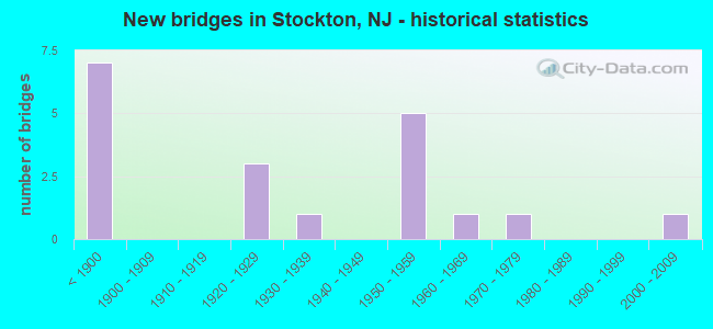
- New bridges - historical statistics
- 7Before 1900
- 31920-1929
- 11930-1939
- 51950-1959
- 11960-1969
- 11970-1979
- 12000-2009

- Reconstructed bridges - Historical Statistics
- 11920-1929
- 01930-1939
- 01940-1949
- 01950-1959
- 01960-1969
- 01970-1979
- 11980-1989
- 41990-1999
- 52000-2009
- 12010-2019


- Bridge Condition - Deck
- 23.5%Very good
- 23.5%Good
- 29.4%Satisfactory
- 17.6%Fair
- 5.9%Poor

- Bridge Condition - Superstructure
- 11.1%Very good
- 22.2%Good
- 22.2%Satisfactory
- 38.9%Fair
- 5.6%Poor

- Bridge Condition - Substructure
- 16.7%Good
- 38.9%Satisfactory
- 38.9%Fair
- 5.6%Poor

- Bridge Condition - Channel
- 10.5%Very good
- 36.8%Good
- 31.6%Satisfactory
- 21.1%Fair
Find on map >> Show street view
Structure Number: 100011, Location: 1.2 MI WEST OF CR 523 (Lat: 40.444000, Lng: -74.966350), Route carried "on" structure: County highway 604, Year Built: 1872, Year Reconstructed: 2003, Status: Open, Structure Length: 2.59m (8.50ft), Average Daily Traffic: 505 (year 2021), Truck Traffic: 5%, Average Future Daily Traffic: 616 (year 2041), Design Load: H 20, Features Intersected: WICKECHEOKE CREEK
Minimum Vertical Clearance: 3.45m (11.32ft), Kilometerpoint: 2.865, Lanes on structure: 1, Owner: County Highway Agency, Approaching Roadway Width: 4.0m (13.1ft), Material/Design: Steel, Design/Construction: Girder and Floorbeam System, Number Of Spans In Main Unit: 1, Length of Maximum Span: 23.5m (77.1ft), Curb-To-Curb Width: 3.7m (12.1ft), Out-to-Out Width: 4.1m (13.5ft)
Condition: Deck: Satisfactory, Superstructure: Fair, Substructure: Satisfactory, Channel: Fair, Operating Rating: 44.5 metric tons, Method Used To Determine Operating Rating: Load Factor (LF), Inventory Rating: 26.3 metric tons, Method Used To Determine Inventory Rating: Load Factor (LF), Structural Evaluation: Somewhat better than minimum adequacy, Deck Geometry: High priority of replacement, Waterway Adequacy: Equal to present desirable criteria, Approach Roadway Alignment: Somewhat better than minimum adequacy, Length Of Structure Improvement: 2.59m (8.50ft), Designated Inspection Frequency: Every 24 months, Critical Feature Inspection Frequency: Every 24 months, Inspection Date: May 2021, Critical Feature Inspection Date: May 2021, Bridge Improvement Cost: $867,000, Roadway Improvement Cost: $50,000, Total Project Cost: $1,289,000 ( Estimate for 2021), Deck Structure Type: Wood or Timber
Find on map >> Show street view
Structure Number: 1000111, Location: 200 FT. N. OF CR 604 (Lat: 40.444750, Lng: -74.964881), Route carried "on" structure: City street , Year Built: 1849, Status: Open, Structure Length: 0.70m (2.30ft), Average Daily Traffic: 145 (year 2021), Truck Traffic: 5%, Average Future Daily Traffic: 177 (year 2041), Features Intersected: TRIB.WICKECHEOKE CREEK, Facility Carried by Structure: PINE HILL ROAD
Minimum Vertical Clearance: 30+ m (98+ ft), Kilometerpoint: 0.000, Lanes on structure: 1, Owner: County Highway Agency, Approaching Roadway Width: 4.9m (16.1ft), Material/Design: Masonry, Design/Construction: Arch - Deck, Number Of Spans In Main Unit: 1, Length of Maximum Span: 7.0m (23.0ft), Curb-To-Curb Width: 4.0m (13.1ft), Out-to-Out Width: 5.1m (16.7ft)
Condition: Superstructure: Satisfactory, Substructure: Satisfactory, Channel: Good, Operating Rating: 41.7 metric tons, Method Used To Determine Operating Rating: Field evaluation and documented engineering judgment, Inventory Rating: 25.4 metric tons, Method Used To Determine Inventory Rating: Field evaluation and documented engineering judgment, Structural Evaluation: Equal to present minimum criteria, Deck Geometry: High priority of replacement, Waterway Adequacy: Better than present minimum criteria, Approach Roadway Alignment: Somewhat better than minimum adequacy, Length Of Structure Improvement: 1.40m (4.59ft), Designated Inspection Frequency: Every 24 months, Inspection Date: March 2021, Bridge Improvement Cost: $483,000, Roadway Improvement Cost: $97,000, Total Project Cost: $802,000 ( Estimate for 2021)
Find on map >> Show street view
Structure Number: 1000112, Location: 0.4 MI.N. OF PAVLICA ROAD (Lat: 40.461750, Lng: -74.967781), Route carried "on" structure: Other road , Year Built: 2001, Status: Open, Structure Length: 1.22m (4.00ft), Average Daily Traffic: 188 (year 2021), Truck Traffic: 3%, Average Future Daily Traffic: 226 (year 2041), Features Intersected: PLUM BROOK, Facility Carried by Structure: PINE HILL ROAD
Minimum Vertical Clearance: 30+ m (98+ ft), Kilometerpoint: 0.000, Lanes on structure: 2, Owner: County Highway Agency, Approaching Roadway Width: 7.2m (23.6ft), Material/Design: Steel, Design/Construction: Stringer/Multi-beam, Number Of Spans In Main Unit: 1, Length of Maximum Span: 11.9m (39.0ft), Curb-To-Curb Width: 7.2m (23.6ft), Out-to-Out Width: 7.3m (24.0ft)
Condition: Deck: Good, Superstructure: Good, Substructure: Satisfactory, Channel: Very good, Operating Rating: 45.4 metric tons, Method Used To Determine Operating Rating: Load Factor (LF), Inventory Rating: 27.2 metric tons, Method Used To Determine Inventory Rating: Load Factor (LF), Structural Evaluation: Equal to present minimum criteria, Deck Geometry: Meets minimum limits, Waterway Adequacy: Better than present minimum criteria, Approach Roadway Alignment: Equal to present minimum criteria, Designated Inspection Frequency: Every 24 months, Inspection Date: March 2021, Deck Structure Type: Corrugated Steel, Wearing Surface/Protective System: Wearing Surface: Bituminous, Membrane: Preformed Fabric
Find on map >> Show street view
Structure Number: 1000115, Location: 75 FT. N. OF OLD MILL RD. (Lat: 40.465439, Lng: -74.976969), Route carried "on" structure: Other road , Year Built: 1925, Year Reconstructed: 1987, Status: Open, Structure Length: 0.79m (2.59ft), Average Daily Traffic: 156 (year 2021), Truck Traffic: 3%, Average Future Daily Traffic: 187 (year 2041), Design Load: HS 20, Features Intersected: WICKECHEOKE CREEK, Facility Carried by Structure: UPPER CREEK ROAD
Minimum Vertical Clearance: 30+ m (98+ ft), Kilometerpoint: 0.000, Lanes on structure: 2, Owner: County Highway Agency, Approaching Roadway Width: 5.4m (17.7ft), Material/Design: Steel, Design/Construction: Stringer/Multi-beam, Number Of Spans In Main Unit: 1, Length of Maximum Span: 7.3m (24.0ft), Curb-To-Curb Width: 5.4m (17.7ft), Out-to-Out Width: 5.9m (19.4ft)
Condition: Deck: Satisfactory, Superstructure: Fair, Substructure: Fair, Channel: Good, Operating Rating: 49.9 metric tons, Method Used To Determine Operating Rating: Field evaluation and documented engineering judgment, Inventory Rating: 29.9 metric tons, Method Used To Determine Inventory Rating: Field evaluation and documented engineering judgment, Structural Evaluation: Somewhat better than minimum adequacy, Deck Geometry: High priority of replacement, Waterway Adequacy: Better than present minimum criteria, Approach Roadway Alignment: Better than present minimum criteria, Length Of Structure Improvement: 0.79m (2.59ft), Designated Inspection Frequency: Every 24 months, Inspection Date: March 2021, Bridge Improvement Cost: $479,000, Roadway Improvement Cost: $100,000, Total Project Cost: $884,000 ( Estimate for 2021), Deck Structure Type: Concrete Cast-file-Place, Wearing Surface/Protective System: Wearing Surface: Gravel
Find on map >> Show street view
Structure Number: 1000116, Location: 0.08 W. OF PINE HILL RD (Lat: 40.443939, Lng: -74.966200), Route carried "on" structure: County highway 604, Year Built: 1961, Year Reconstructed: 2003, Status: Open, Structure Length: 2.44m (8.01ft), Average Daily Traffic: 490 (year 2021), Truck Traffic: 4%, Average Future Daily Traffic: 590 (year 2041), Design Load: H 20, Features Intersected: WICKECHEOKE CREEK
Minimum Vertical Clearance: 30+ m (98+ ft), Kilometerpoint: 2.865, Lanes on structure: 1, Owner: County Highway Agency, Approaching Roadway Width: 4.3m (14.1ft), Material/Design: Steel, Design/Construction: Stringer/Multi-beam, Number Of Spans In Main Unit: 1, Length of Maximum Span: 23.2m (76.1ft), Curb or Sidewalk Widths: Left: 0.3m (1.0ft), Right: 0.3m (1.0ft), Curb-To-Curb Width: 4.3m (14.1ft), Out-to-Out Width: 5.9m (19.4ft)
Condition: Deck: Satisfactory, Superstructure: Good, Substructure: Satisfactory, Channel: Good, Inventory Rating: 59.9 metric tons, Method Used To Determine Inventory Rating: Load Factor (LF), Structural Evaluation: Equal to present minimum criteria, Deck Geometry: High priority of replacement, Waterway Adequacy: Equal to present desirable criteria, Approach Roadway Alignment: Meets minimum limits, Length Of Structure Improvement: 2.44m (8.01ft), Designated Inspection Frequency: Every 24 months, Critical Feature Inspection Frequency: Every 24 months, Inspection Date: April 2021, Critical Feature Inspection Date: April 2021, Bridge Improvement Cost: $196,000, Roadway Improvement Cost: $50,000, Total Project Cost: $385,000 ( Estimate for 2021), Deck Structure Type: Concrete Cast-file-Place, Wearing Surface/Protective System: Wearing Surface: Latex Concrete, Deck Protection: Internally Sealed
Find on map >> Show street view
Structure Number: 1007153, Location: 0.12 MI S OF RT 202 JCT (Lat: 40.380439, Lng: -74.947939), Route carried "on" structure: State highway 29, Year Built: 1976, Status: Open, Structure Length: 5.03m (16.50ft), Average Daily Traffic: 8,100 (year 2021), Truck Traffic: 4%, Average Future Daily Traffic: 9,720 (year 2041), Design Load: HS 20+Mod, Features Intersected: ALEXAUKEN CREEK
Minimum Vertical Clearance: 30+ m (98+ ft), Kilometerpoint: 32.123, Lanes on structure: 4, Base Highway Network: Yes, Owner: State Highway Agency, Approaching Roadway Width: 15.5m (50.9ft), Skew: 5 degrees, Material/Design: Steel, Design/Construction: Stringer/Multi-beam, Number Of Spans In Main Unit: 2, Length of Maximum Span: 25.0m (82.0ft), Curb or Sidewalk Widths: Left: 0.2m (0.7ft), Right: 1.8m (5.9ft), Curb-To-Curb Width: 15.6m (51.2ft), Out-to-Out Width: 18.3m (60.0ft)
Condition: Deck: Good, Superstructure: Satisfactory, Substructure: Good, Channel: Satisfactory, Inventory Rating: 63.5 metric tons, Method Used To Determine Inventory Rating: Load Factor (LF), Structural Evaluation: Equal to present minimum criteria, Deck Geometry: Meets minimum limits, Waterway Adequacy: Superior to present desirable criteria, Approach Roadway Alignment: Better than present minimum criteria, Designated Inspection Frequency: Every 24 months, Inspection Date: October 2021, Deck Structure Type: Concrete Cast-file-Place, Wearing Surface/Protective System: Wearing Surface: Monolithic Concrete, Deck Protection: Galvanized Reinforcing
Find on map >> Show street view
Structure Number: 1007159, Location: 2.96 MILE NORTH OF US 202 (Lat: 40.411500, Lng: -74.986281), Route carried "on" structure: State highway 29, Year Built: 1934, Year Reconstructed: 2015, Status: Open, Structure Length: 3.54m (11.61ft), Average Daily Traffic: 6,222 (year 2018), Truck Traffic: 4%, Average Future Daily Traffic: 7,467 (year 2038), Design Load: HL 93, Features Intersected: WICKECHEOKE CREEK
Minimum Vertical Clearance: 30+ m (98+ ft), Kilometerpoint: 37.063, Lanes on structure: 2, Base Highway Network: Yes, Owner: State Highway Agency, Approaching Roadway Width: 9.1m (29.9ft), Skew: 3 degrees, Material/Design: Prestressed concrete, Design/Construction: Tee Beam, Number Of Spans In Main Unit: 2, Length of Maximum Span: 17.1m (56.1ft), Curb-To-Curb Width: 9.1m (29.9ft), Out-to-Out Width: 10.4m (34.1ft)
Condition: Deck: Good, Superstructure: Very good, Substructure: Good, Channel: Good, Operating Rating: 89.8 metric tons, Method Used To Determine Operating Rating: Field evaluation and documented engineering judgment, Inventory Rating: 89.8 metric tons, Method Used To Determine Inventory Rating: Field evaluation and documented engineering judgment, Structural Evaluation: Better than present minimum criteria, Deck Geometry: High priority of corrective action, Waterway Adequacy: Equal to present desirable criteria, Approach Roadway Alignment: Somewhat better than minimum adequacy, Length Of Structure Improvement: 3.54m (11.61ft), Designated Inspection Frequency: Every 24 months, Inspection Date: July 2020, Bridge Improvement Cost: $348,000, Roadway Improvement Cost: $125,000, Total Project Cost: $616,000 ( Estimate for 2018), Deck Structure Type: Concrete Cast-file-Place, Wearing Surface/Protective System: Membrane: Epoxy, Deck Protection: Epoxy Coated Reinforcing
Find on map >> Show street view
Structure Number: 100815, Location: 4.5 MI NW OF US.202-2GJCT (Lat: 40.408031, Lng: -75.014000), Route carried "on" structure: State highway 29, Year Built: 1950, Status: Open, Structure Length: 3.23m (10.60ft), Average Daily Traffic: 5,532 (year 2020), Truck Traffic: 4%, Average Future Daily Traffic: 6,757 (year 2040), Design Load: HS 20, Features Intersected: LOCKATONG CREEK
Minimum Vertical Clearance: 30+ m (98+ ft), Kilometerpoint: 39.558, Lanes on structure: 2, Base Highway Network: Yes, Owner: State Highway Agency, Approaching Roadway Width: 12.2m (40.0ft), Material/Design: Steel, Design/Construction: Stringer/Multi-beam, Number Of Spans In Main Unit: 2, Length of Maximum Span: 15.8m (51.8ft), Curb or Sidewalk Widths: Left: 1.2m (3.9ft), Right: 1.8m (5.9ft), Curb-To-Curb Width: 12.3m (40.4ft), Out-to-Out Width: 16.3m (53.5ft)
Condition: Deck: Fair, Superstructure: Fair, Substructure: Satisfactory, Channel: Satisfactory, Operating Rating: 46.3 metric tons, Method Used To Determine Operating Rating: Load Factor (LF), Inventory Rating: 28.1 metric tons, Method Used To Determine Inventory Rating: Load Factor (LF), Structural Evaluation: Somewhat better than minimum adequacy, Deck Geometry: Somewhat better than minimum adequacy, Waterway Adequacy: Equal to present minimum criteria, Approach Roadway Alignment: Equal to present desirable criteria, Designated Inspection Frequency: Every 24 months, Inspection Date: July 2020, Deck Structure Type: Concrete Cast-file-Place, Wearing Surface/Protective System: Wearing Surface: Bituminous
Find on map >> Show street view
Structure Number: 100D325, Location: 0.7 MILE NORTH OF CR 519 (Lat: 40.421781, Lng: -74.979881), Route carried "on" structure: City street , Year Built: 1889, Year Reconstructed: 2001, Status: Open, Structure Length: 3.08m (10.10ft), Average Daily Traffic: 322 (year 2021), Truck Traffic: 3%, Average Future Daily Traffic: 393 (year 2041), Features Intersected: WICKECHEOKE CREEK, Facility Carried by Structure: LOWER CREEK ROAD
Minimum Vertical Clearance: 30+ m (98+ ft), Kilometerpoint: 0.000, Lanes on structure: 1, Owner: County Highway Agency, Approaching Roadway Width: 4.6m (15.1ft), Material/Design: Steel, Design/Construction: Truss - Thru, Number Of Spans In Main Unit: 2, Length of Maximum Span: 14.9m (48.9ft), Curb-To-Curb Width: 4.2m (13.8ft), Out-to-Out Width: 4.4m (14.4ft)
Condition: Deck: Satisfactory, Superstructure: Fair, Substructure: Fair, Channel: Fair, Operating Rating: 39.0 metric tons, Method Used To Determine Operating Rating: Load Factor (LF), Inventory Rating: 23.6 metric tons, Method Used To Determine Inventory Rating: Load Factor (LF), Structural Evaluation: Somewhat better than minimum adequacy, Deck Geometry: High priority of replacement, Waterway Adequacy: Equal to present desirable criteria, Approach Roadway Alignment: Meets minimum limits, Length Of Structure Improvement: 4.02m (13.19ft), Designated Inspection Frequency: Every 24 months, Critical Feature Inspection Frequency: Every 24 months, Inspection Date: May 2021, Critical Feature Inspection Date: May 2021, Bridge Improvement Cost: $1,479,000, Roadway Improvement Cost: $50,000, Total Project Cost: $2,458,000 ( Estimate for 2021), Deck Structure Type: Corrugated Steel, Wearing Surface/Protective System: Wearing Surface: Bituminous
Find on map >> Show street view
Structure Number: 100D488, Location: 2 MILES NORTH OF CR 604 (Lat: 40.464739, Lng: -74.976711), Route carried "on" structure: City street , Year Built: 1899, Status: Open, Structure Length: 1.49m (4.89ft), Average Daily Traffic: 124 (year 2021), Truck Traffic: 3%, Average Future Daily Traffic: 151 (year 2041), Features Intersected: WICKECHEOKE CREEK, Facility Carried by Structure: OLD MILL ROAD
Minimum Vertical Clearance: 30+ m (98+ ft), Kilometerpoint: 0.000, Lanes on structure: 1, Owner: County Highway Agency, Approaching Roadway Width: 3.7m (12.1ft), Skew: 1 degrees, Material/Design: Steel, Design/Construction: Truss - Thru, Number Of Spans In Main Unit: 1, Length of Maximum Span: 14.3m (46.9ft), Curb-To-Curb Width: 3.4m (11.2ft), Out-to-Out Width: 3.5m (11.5ft)
Condition: Deck: Fair, Superstructure: Fair, Substructure: Fair, Channel: Satisfactory, Operating Rating: 30.8 metric tons, Method Used To Determine Operating Rating: Load Factor (LF), Inventory Rating: 18.1 metric tons, Method Used To Determine Inventory Rating: Load Factor (LF), Structural Evaluation: Somewhat better than minimum adequacy, Deck Geometry: High priority of replacement, Waterway Adequacy: Superior to present desirable criteria, Approach Roadway Alignment: Somewhat better than minimum adequacy, Length Of Structure Improvement: 2.16m (7.09ft), Designated Inspection Frequency: Every 24 months, Critical Feature Inspection Frequency: Every 24 months, Inspection Date: April 2021, Critical Feature Inspection Date: April 2021, Bridge Improvement Cost: $682,000, Roadway Improvement Cost: $50,000, Total Project Cost: $1,174,000 ( Estimate for 2021), Deck Structure Type: Corrugated Steel, Wearing Surface/Protective System: Wearing Surface: Bituminous, Membrane: Preformed Fabric
Find on map >> Show street view
Structure Number: 100D494, Location: 2 MILES EAST OF CR 519 (Lat: 40.465219, Lng: -74.980969), Route carried "on" structure: Other road , Year Built: 1955, Year Reconstructed: 2012, Status: Open, Structure Length: 0.70m (2.30ft), Average Daily Traffic: 94 (year 2021), Truck Traffic: 3%, Average Future Daily Traffic: 114 (year 2041), Features Intersected: BR OF WICKECHEOKE CK, Facility Carried by Structure: FEATHERBED LANE
Minimum Vertical Clearance: 30+ m (98+ ft), Kilometerpoint: 0.000, Lanes on structure: 2, Owner: County Highway Agency, Approaching Roadway Width: 5.9m (19.4ft), Material/Design: Steel, Design/Construction: Stringer/Multi-beam, Number Of Spans In Main Unit: 1, Length of Maximum Span: 6.4m (21.0ft), Curb-To-Curb Width: 5.5m (18.0ft), Out-to-Out Width: 5.9m (19.4ft)
Condition: Deck: Very good, Superstructure: Very good, Substructure: Satisfactory, Channel: Satisfactory, Operating Rating: 88.0 metric tons, Method Used To Determine Operating Rating: Load Factor (LF), Inventory Rating: 52.6 metric tons, Method Used To Determine Inventory Rating: Load Factor (LF), Structural Evaluation: Equal to present minimum criteria, Deck Geometry: Meets minimum limits, Waterway Adequacy: Better than present minimum criteria, Approach Roadway Alignment: Somewhat better than minimum adequacy, Designated Inspection Frequency: Every 24 months, Inspection Date: March 2021, Deck Structure Type: Corrugated Steel, Wearing Surface/Protective System: Wearing Surface: Bituminous
Find on map >> Show street view
Structure Number: 100K087, Location: 0.7 MILE WEST OF CR 519 (Lat: 40.453150, Lng: -75.024489), Route carried "on" structure: City street , Year Built: 1850, Year Reconstructed: 1929, Status: Posted for load, Structure Length: 1.65m (5.41ft), Average Daily Traffic: 94 (year 2021), Average Future Daily Traffic: 115 (year 2041), Features Intersected: LOCKATONG CREEK, Facility Carried by Structure: MILLTOWN ROAD
Minimum Vertical Clearance: 30+ m (98+ ft), Kilometerpoint: 0.000, Lanes on structure: 1, Owner: County Highway Agency, Approaching Roadway Width: 4.0m (13.1ft), Material/Design: Steel, Design/Construction: Truss - Thru, Number Of Spans In Main Unit: 1, Length of Maximum Span: 15.8m (51.8ft), Curb-To-Curb Width: 4.3m (14.1ft), Out-to-Out Width: 4.5m (14.8ft)
Condition: Deck: Fair, Superstructure: Poor, Substructure: Fair, Channel: Fair, Operating Rating: 25.4 metric tons, Method Used To Determine Operating Rating: Load Factor (LF), Inventory Rating: 15.4 metric tons, Method Used To Determine Inventory Rating: Load Factor (LF), Structural Evaluation: Meets minimum limits, Deck Geometry: Equal to present minimum criteria, Waterway Adequacy: Superior to present desirable criteria, Approach Roadway Alignment: Meets minimum limits, Length Of Structure Improvement: 2.38m (7.81ft), Designated Inspection Frequency: Every 24 months, Critical Feature Inspection Frequency: Every 24 months, Inspection Date: May 2021, Critical Feature Inspection Date: May 2021, Bridge Improvement Cost: $819,000, Roadway Improvement Cost: $50,000, Total Project Cost: $1,223,000 ( Estimate for 2021), Deck Structure Type: Concrete Cast-file-Place, Wearing Surface/Protective System: Wearing Surface: Bituminous
Find on map >> Show street view
Structure Number: 10XX3, Location: 1.6 MILES WEST OF RT 519 (Lat: 40.416181, Lng: -75.017681), Route carried "on" structure: City street , Year Built: 1878, Year Reconstructed: 2014, Status: Posted for load, Structure Length: 3.93m (12.89ft), Average Daily Traffic: 208 (year 2021), Average Future Daily Traffic: 254 (year 2041), Design Load: H 15, Features Intersected: LOCKATONG CREEK, Facility Carried by Structure: RAVEN RCK-ROSMT RD
Minimum Vertical Clearance: 4.88m (16.01ft), Kilometerpoint: 0.000, Lanes on structure: 1, Owner: County Highway Agency, Approaching Roadway Width: 4.9m (16.1ft), Material/Design: Aluminum, Iron, Design/Construction: Truss - Thru, Number Of Spans In Main Unit: 1, Length of Maximum Span: 38.7m (127.0ft), Curb-To-Curb Width: 4.3m (14.1ft), Out-to-Out Width: 4.7m (15.4ft)
Condition: Deck: Very good, Superstructure: Good, Substructure: Good, Channel: Fair, Operating Rating: 32.7 metric tons, Method Used To Determine Operating Rating: Allowable Stress (AS), Inventory Rating: 16.3 metric tons, Method Used To Determine Inventory Rating: Allowable Stress (AS), Structural Evaluation: Somewhat better than minimum adequacy, Deck Geometry: High priority of replacement, Waterway Adequacy: Better than present minimum criteria, Approach Roadway Alignment: Better than present minimum criteria, Length Of Structure Improvement: 4.85m (15.91ft), Designated Inspection Frequency: Every 24 months, Critical Feature Inspection Frequency: Every 24 months, Inspection Date: April 2021, Critical Feature Inspection Date: April 2021, Bridge Improvement Cost: $1,781,000, Roadway Improvement Cost: $50,000, Total Project Cost: $2,551,000 ( Estimate for 2021), Deck Structure Type: Corrugated Steel, Wearing Surface/Protective System: Wearing Surface: Bituminous, Membrane: Preformed Fabric
Find on map >> Show street view
Structure Number: 10XX481, Location: .8 MILES SW OF CR 519 (Lat: 40.437050, Lng: -75.011861), Route carried "on" structure: City street , Year Built: 1897, Year Reconstructed: 2005, Status: Posted for load, Structure Length: 2.90m (9.51ft), Average Daily Traffic: 124 (year 2021), Truck Traffic: 3%, Average Future Daily Traffic: 151 (year 2041), Features Intersected: LOCKATONG CREEK, Facility Carried by Structure: STRIMPLES MILL RD.
Minimum Vertical Clearance: 4.34m (14.24ft), Kilometerpoint: 0.000, Lanes on structure: 1, Owner: County Highway Agency, Approaching Roadway Width: 4.9m (16.1ft), Material/Design: Aluminum, Iron, Design/Construction: Truss - Thru, Number Of Spans In Main Unit: 1, Length of Maximum Span: 28.3m (92.8ft), Curb-To-Curb Width: 4.5m (14.8ft), Out-to-Out Width: 4.9m (16.1ft)
Condition: Deck: Very good, Superstructure: Satisfactory, Substructure: Satisfactory, Channel: Satisfactory, Operating Rating: 29.9 metric tons, Method Used To Determine Operating Rating: Allowable Stress (AS), Inventory Rating: 19.1 metric tons, Method Used To Determine Inventory Rating: Allowable Stress (AS), Structural Evaluation: Somewhat better than minimum adequacy, Deck Geometry: High priority of replacement, Waterway Adequacy: Better than present minimum criteria, Approach Roadway Alignment: Meets minimum limits, Length Of Structure Improvement: 3.78m (12.40ft), Designated Inspection Frequency: Every 24 months, Critical Feature Inspection Frequency: Every 24 months, Inspection Date: July 2021, Critical Feature Inspection Date: July 2021, Bridge Improvement Cost: $1,389,000, Roadway Improvement Cost: $50,000, Total Project Cost: $2,009,000 ( Estimate for 2021), Deck Structure Type: Corrugated Steel, Wearing Surface/Protective System: Wearing Surface: Bituminous, Membrane: Preformed Fabric
Find on map >> Show street view
Structure Number: 300117, Location: AT MP 13.74 of NJ Rt 29 (Lat: 40.314239, Lng: -74.891000), Route carried "on" structure: City street , Year Built: 1953, Year Reconstructed: 1999, Status: Posted for load, Structure Length: 1.01m (3.31ft), Average Daily Traffic: 57 (year 2020), Truck Traffic: 1%, Average Future Daily Traffic: 78 (year 2040), Features Intersected: D&R FEEDER CANAL, Facility Carried by Structure: RIVER DRIVE
Minimum Vertical Clearance: 30+ m (98+ ft), Kilometerpoint: 0.000, Lanes on structure: 2, Owner: State Highway Agency, Approaching Roadway Width: 5.6m (18.4ft), Skew: 1 degrees, Material/Design: Wood or Timber, Design/Construction: Stringer/Multi-beam, Number Of Spans In Main Unit: 2, Length of Maximum Span: 4.6m (15.1ft), Curb-To-Curb Width: 5.6m (18.4ft), Out-to-Out Width: 6.4m (21.0ft)
Condition: Deck: Very good, Superstructure: Good, Substructure: Poor, Channel: Very good, Operating Rating: 19.1 metric tons, Method Used To Determine Operating Rating: Allowable Stress (AS), Inventory Rating: 13.6 metric tons, Method Used To Determine Inventory Rating: Allowable Stress (AS), Structural Evaluation: Meets minimum limits, Deck Geometry: Meets minimum limits, Waterway Adequacy: Equal to present desirable criteria, Approach Roadway Alignment: Better than present minimum criteria, Bridge Posting: Required (Relationship of Operating Rating to Maximum Legal Load: 10.0 - 19.9% below), Length Of Structure Improvement: 1.01m (3.31ft), Designated Inspection Frequency: Every 24 months, Underwater Inspection Frequency: Every 48 months, Other Special Inspection Frequency: Every 12 months, Inspection Date: May 2020, Underwater Inspection Date: May 2018, Other Special Inspection Date: April 2021, Bridge Improvement Cost: $48,000, Total Project Cost: $60,000 ( Estimate for 2020), Deck Structure Type: Wood or Timber, Wearing Surface/Protective System: Wearing Surface: Wood or Timber
Find on map >> Show street view
Structure Number: 3001178, Location: 650' W OF NJ 29 MP 22.37 (Lat: 40.404331, Lng: -74.978539), Route carried "on" structure: City street , Year Built: 1926, Status: Open, Structure Length: 1.74m (5.71ft), Average Daily Traffic: 4,633 (year 2020), Truck Traffic: 3%, Average Future Daily Traffic: 5,560 (year 2040), Features Intersected: D&R FEEDER CANAL, Facility Carried by Structure: BRIDGE STREET
Minimum Vertical Clearance: 30+ m (98+ ft), Kilometerpoint: 0.000, Lanes on structure: 2, Owner: State Highway Agency, Approaching Roadway Width: 6.1m (20.0ft), Material/Design: Concrete, Design/Construction: Tee Beam, Number Of Spans In Main Unit: 2, Length of Maximum Span: 8.2m (26.9ft), Curb or Sidewalk Widths: Left: 1.9m (6.2ft), Right: 1.9m (6.2ft), Curb-To-Curb Width: 6.1m (20.0ft), Out-to-Out Width: 10.4m (34.1ft)
Condition: Deck: Poor, Superstructure: Fair, Substructure: Fair, Channel: Satisfactory, Operating Rating: 54.4 metric tons, Method Used To Determine Operating Rating: Load Factor (LF), Inventory Rating: 32.7 metric tons, Method Used To Determine Inventory Rating: Load Factor (LF), Structural Evaluation: Somewhat better than minimum adequacy, Deck Geometry: High priority of replacement, Waterway Adequacy: Equal to present desirable criteria, Approach Roadway Alignment: Equal to present desirable criteria, Length Of Structure Improvement: 1.74m (5.71ft), Designated Inspection Frequency: Every 24 months, Underwater Inspection Frequency: Every 48 months, Inspection Date: May 2020, Underwater Inspection Date: March 2020, Bridge Improvement Cost: $876,000, Roadway Improvement Cost: $140,000, Total Project Cost: $1,399,000 ( Estimate for 2020), Deck Structure Type: Concrete Cast-file-Place, Wearing Surface/Protective System: Wearing Surface: Bituminous
Find on map >> Show street view
Structure Number: 3001179, Location: 500' S OF WICKECHEOKE CRK (Lat: 40.408331, Lng: -74.985050), Route carried "on" structure: ServiceState lands road 3001, Year Built: 1952, Status: Open, Structure Length: 0.98m (3.22ft), Average Daily Traffic: 13 (year 2020), Truck Traffic: 1%, Average Future Daily Traffic: 16 (year 2040), Features Intersected: D&R FEEDER CANAL, Facility Carried by Structure: PRALLSVILLE CULVRT
Minimum Vertical Clearance: 30+ m (98+ ft), Kilometerpoint: 0.000, Lanes on structure: 1, Owner: State Agenciy, Maintenance Responsibility: State Highway Agency, Approaching Roadway Width: 4.6m (15.1ft), Material/Design: Concrete, Design/Construction: Culvert, Number Of Spans In Main Unit: 2, Length of Maximum Span: 4.3m (14.1ft), Out-to-Out Width: 4.6m (15.1ft)
Condition: Channel: Good, Culverts: Satisfactory, Operating Rating: 89.8 metric tons, Method Used To Determine Operating Rating: Load Factor (LF), Inventory Rating: 89.8 metric tons, Method Used To Determine Inventory Rating: Load Factor (LF), Structural Evaluation: Equal to present minimum criteria, Waterway Adequacy: Equal to present desirable criteria, Approach Roadway Alignment: Meets minimum limits, Designated Inspection Frequency: Every 24 months, Underwater Inspection Frequency: Every 24 months, Inspection Date: Febuary 2020, Underwater Inspection Date: March 2020
Find on map >> Show street view
Structure Number: 300118, Location: QUARRY RD, RT29 MP25.5+/- (Lat: 40.410369, Lng: -75.034819), Route carried "on" structure: ServiceState lands road , Year Built: 1950, Year Reconstructed: 2009, Status: Open, Structure Length: 0.94m (3.08ft), Average Daily Traffic: 699 (year 2021), Truck Traffic: 3%, Average Future Daily Traffic: 839 (year 2041), Design Load: HS 20, Features Intersected: D&R CANAL FEEDER, Facility Carried by Structure: RAVEN ROCK BRIDGE
Minimum Vertical Clearance: 30+ m (98+ ft), Kilometerpoint: 0.000, Lanes on structure: 1, Owner: State Highway Agency, Approaching Roadway Width: 3.7m (12.1ft), Material/Design: Steel, Design/Construction: Stringer/Multi-beam, Number Of Spans In Main Unit: 1, Length of Maximum Span: 8.5m (27.9ft), Curb-To-Curb Width: 3.9m (12.8ft), Out-to-Out Width: 4.2m (13.8ft)
Condition: Deck: Satisfactory, Superstructure: Satisfactory, Substructure: Fair, Channel: Good, Operating Rating: 49.9 metric tons, Method Used To Determine Operating Rating: Load Factor (LF), Inventory Rating: 29.9 metric tons, Method Used To Determine Inventory Rating: Load Factor (LF), Structural Evaluation: Somewhat better than minimum adequacy, Deck Geometry: High priority of replacement, Waterway Adequacy: Equal to present desirable criteria, Approach Roadway Alignment: Better than present minimum criteria, Length Of Structure Improvement: 0.94m (3.08ft), Designated Inspection Frequency: Every 24 months, Underwater Inspection Frequency: Every 48 months, Inspection Date: October 2021, Underwater Inspection Date: July 2019, Bridge Improvement Cost: $29,000, Roadway Improvement Cost: $77,000, Total Project Cost: $139,000 ( Estimate for 2021), Deck Structure Type: Wood or Timber, Wearing Surface/Protective System: Wearing Surface: Wood or Timber
Find on map >> Show street view
Structure Number: 330016, Location: 0.2mi SW of NJ29-BridgeSt (Lat: 40.403119, Lng: -74.979389), Route carried "on" structure: State highway 29, Year Built: 1926, Year Reconstructed: 2007, Status: Posted for load, Structure Length: 25.15m (82.51ft), Average Daily Traffic: 4,600 (year 2020), Average Future Daily Traffic: 5,500 (year 2040), Features Intersected: DELAWARE River
Minimum Vertical Clearance: 3.89m (12.76ft), Kilometerpoint: 0.000, Lanes on structure: 2, Owner: Local Toll Authority, Approaching Roadway Width: 6.7m (22.0ft), Material/Design: Steel, Design/Construction: Truss - Thru, Number Of Spans In Main Unit: 6, Length of Maximum Span: 46.3m (151.9ft), Curb or Sidewalk Widths: Left: 0.0m, Right: 1.8m (5.9ft), Curb-To-Curb Width: 6.1m (20.0ft), Out-to-Out Width: 6.6m (21.7ft)
Condition: Deck: Good, Superstructure: Fair, Substructure: Fair, Channel: Good, Operating Rating: 13.7 metric tons, Method Used To Determine Operating Rating: Load Factor (LF), Structural Evaluation: High priority of corrective action, Deck Geometry: High priority of replacement, Waterway Adequacy: Equal to present desirable criteria, Approach Roadway Alignment: Equal to present minimum criteria, Bridge Posting: Required (Relationship of Operating Rating to Maximum Legal Load: > 39.9% below), Length Of Structure Improvement: 25.60m (83.99ft), Designated Inspection Frequency: Every 24 months, Critical Feature Inspection Frequency: Every 24 months, Underwater Inspection Frequency: Every 60 months, Other Special Inspection Frequency: Every 12 months, Inspection Date: April 2020, Critical Feature Inspection Date: April 2020, Underwater Inspection Date: November 2016, Other Special Inspection Date: April 2021, Total Project Cost: $1,000, Deck Structure Type: Open Grating