Bridge Statistics for Stone Mountain, Georgia (GA)
Condition, Traffic, Stress, Structural Evaluation, Project Costs
- National Bridge Inventory (NBI) Statistics
- 21Number of bridges
- 125ft / 38.0mTotal length
- $9,991,000Total costs
- 654,812Total average daily traffic
- 6,882Total average daily truck traffic
- National Bridge Inventory (NBI) Registered Bridges for Stone Mountain
- No street view available for this location
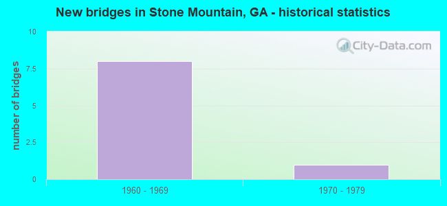
- New bridges - historical statistics
- 81960-1969
- 11970-1979


- Bridge Condition - Deck
- 40.0%Good
- 60.0%Satisfactory

- Bridge Condition - Superstructure
- 60.0%Very good
- 40.0%Good

- Bridge Condition - Substructure
- 80.0%Good
- 20.0%Satisfactory

- Bridge Condition - Channel
- 25.0%Very good
- 50.0%Good
- 25.0%Satisfactory
Find on map >> Show street view
Structure Number: 890011, Location: 1.4 MI NE OF STONE MTN (Lat: 33.823467, Lng: -84.155964), Route carried "on" structure: US 78, Year Built: 1963, Status: Open, Structure Length: 0.98m (3.22ft), Average Daily Traffic: 96,210 (year 2011), Truck Traffic: 1%, Average Future Daily Traffic: 144,315 (year 2031), Design Load: HS 20+Mod, Features Intersected: STONE MOUNTAIN CREEK
Minimum Vertical Clearance: 30+ m (98+ ft), Kilometerpoint: 19.312, Lanes on structure: 8, Base Highway Network: Yes, Owner: State Highway Agency, Approaching Roadway Width: 34.1m (111.9ft), Skew: 30 degrees, Material/Design: Concrete, Design/Construction: Culvert, Number Of Spans In Main Unit: 3, Length of Maximum Span: 3.0m (9.8ft)
Condition: Channel: Very good, Culverts: Good, Structural Evaluation: Better than present minimum criteria, Waterway Adequacy: Equal to present minimum criteria, Approach Roadway Alignment: Equal to present desirable criteria, Designated Inspection Frequency: Every 24 months, Underwater Inspection Frequency: Every 60 months, Inspection Date: June 2020, Underwater Inspection Date: April 2019, Bridge Improvement Cost: $330,000, Roadway Improvement Cost: $33,000, Total Project Cost: $494,000
Find on map >> Show street view
Structure Number: 890012, Location: 1.5 MI NE OF STONE MTN (Lat: 33.824006, Lng: -84.152256), Route carried "on" structure: US 78, Year Built: 1963, Year Reconstructed: 1989, Status: Open, Structure Length: 4.57m (14.99ft), Average Daily Traffic: 79,030 (year 2011), Truck Traffic: 1%, Average Future Daily Traffic: 118,545 (year 2031), Design Load: HS 20+Mod, Features Intersected: SR 236 HUGH HOWELL RD, S
Minimum Vertical Clearance: 30+ m (98+ ft), Kilometerpoint: 19.312, Lanes on structure: 7, Lanes under structure: 3, Base Highway Network: Yes, Owner: State Highway Agency, Approaching Roadway Width: 35.4m (116.1ft), Skew: 33 degrees, Material/Design: Steel, Design/Construction: Stringer/Multi-beam, Number Of Spans In Main Unit: 4, Length of Maximum Span: 13.1m (43.0ft), Curb-To-Curb Width: 35.4m (116.1ft), Out-to-Out Width: 37.8m (124.0ft)
Condition: Deck: Satisfactory, Superstructure: Very good, Substructure: Good, Operating Rating: 34.4 metric tons, Method Used To Determine Operating Rating: Allowable Stress (AS), Inventory Rating: 20.8 metric tons, Method Used To Determine Inventory Rating: Allowable Stress (AS), Structural Evaluation: Somewhat better than minimum adequacy, Deck Geometry: Superior to present desirable criteria, Approach Roadway Alignment: Equal to present desirable criteria, Length Of Structure Improvement: 11.40m (37.40ft), Designated Inspection Frequency: Every 24 months, Inspection Date: June 2020, Bridge Improvement Cost: $1,385,000, Roadway Improvement Cost: $139,000, Total Project Cost: $2,078,000, Deck Structure Type: Concrete Cast-file-Place
Find on map >> Show street view
Structure Number: 890113, Location: 0.9 MI N OF STONE MTN (Lat: 33.820919, Lng: -84.168975), Route carried "on" structure: US 78, Year Built: 1966, Year Reconstructed: 1989, Status: Open, Structure Length: 5.64m (18.50ft), Average Daily Traffic: 86,300 (year 2011), Truck Traffic: 1%, Average Future Daily Traffic: 129,450 (year 2031), Design Load: HS 20+Mod, Features Intersected: SR 10 WBL- SR 10R TO 78W
Minimum Vertical Clearance: 30+ m (98+ ft), Kilometerpoint: 19.312, Lanes on structure: 6, Lanes under structure: 3, Base Highway Network: Yes, Owner: State Highway Agency, Approaching Roadway Width: 30.5m (100.1ft), Skew: 33 degrees, Material/Design: Steel, Design/Construction: Stringer/Multi-beam, Number Of Spans In Main Unit: 4, Length of Maximum Span: 15.5m (50.9ft), Curb-To-Curb Width: 35.8m (117.5ft), Out-to-Out Width: 37.4m (122.7ft)
Condition: Deck: Satisfactory, Superstructure: Very good, Substructure: Satisfactory, Operating Rating: 39.9 metric tons, Method Used To Determine Operating Rating: Load Factor (LF), Inventory Rating: 23.5 metric tons, Method Used To Determine Inventory Rating: Load Factor (LF), Structural Evaluation: Somewhat better than minimum adequacy, Deck Geometry: Superior to present desirable criteria, Underclear: Somewhat better than minimum adequacy, Approach Roadway Alignment: Equal to present desirable criteria, Designated Inspection Frequency: Every 24 months, Inspection Date: June 2020, Bridge Improvement Cost: $1,511,000, Roadway Improvement Cost: $151,000, Total Project Cost: $2,267,000, Deck Structure Type: Concrete Cast-file-Place
Find on map >> Show street view
Structure Number: 890119, Location: 1.2 MI N OF STONE MTN (Lat: 33.822808, Lng: -84.159089), Route carried "on" structure: County highway 1048, Year Built: 1963, Status: Open, Structure Length: 6.46m (21.19ft), Average Daily Traffic: 7,280 (year 2011), Truck Traffic: 1%, Average Future Daily Traffic: 10,920 (year 2031), Design Load: HS 20+Mod, Features Intersected: SR 10 (US 78), Facility Carried by Structure: SILVER HILL ROAD
Minimum Vertical Clearance: 30+ m (98+ ft), Kilometerpoint: 1.609, Lanes on structure: 2, Lanes under structure: 8, Base Highway Network: Yes, Owner: State Highway Agency, Approaching Roadway Width: 7.3m (24.0ft), Material/Design: Steel continuous, Design/Construction: Stringer/Multi-beam, Number Of Spans In Main Unit: 4, Length of Maximum Span: 18.9m (62.0ft), Curb or Sidewalk Widths: Left: 0.6m (2.0ft), Right: 0.6m (2.0ft), Curb-To-Curb Width: 7.3m (24.0ft), Out-to-Out Width: 9.3m (30.5ft)
Condition: Deck: Good, Superstructure: Good, Substructure: Good, Operating Rating: 37.1 metric tons, Method Used To Determine Operating Rating: Load Factor (LF), Inventory Rating: 22.6 metric tons, Method Used To Determine Inventory Rating: Load Factor (LF), Structural Evaluation: Somewhat better than minimum adequacy, Deck Geometry: High priority of replacement, Underclear: High priority of replacement, Approach Roadway Alignment: Meets minimum limits, Length Of Structure Improvement: 46.73m (153.31ft), Designated Inspection Frequency: Every 24 months, Inspection Date: June 2020, Bridge Improvement Cost: $828,000, Roadway Improvement Cost: $83,000, Total Project Cost: $1,242,000, Deck Structure Type: Concrete Cast-file-Place
Find on map >> Show street view
Structure Number: 890129, Location: 1.5 MI NW OF STONE MTN (Lat: 33.828744, Lng: -84.178181), Route carried "on" structure: County highway 4869, Year Built: 1967, Status: Open, Structure Length: 9.94m (32.61ft), Average Daily Traffic: 2,202 (year 2011), Truck Traffic: 1%, Average Future Daily Traffic: 3,303 (year 2031), Design Load: HS 20+Mod, Features Intersected: SR 410 STONE MTN FREEWAY, Facility Carried by Structure: JULIETT ROAD
Minimum Vertical Clearance: 30+ m (98+ ft), Kilometerpoint: 1.609, Lanes on structure: 2, Lanes under structure: 6, Base Highway Network: Yes, Owner: State Highway Agency, Approaching Roadway Width: 6.4m (21.0ft), Skew: 3 degrees, Material/Design: Steel continuous, Design/Construction: Stringer/Multi-beam, Number Of Spans In Main Unit: 4, Length of Maximum Span: 31.1m (102.0ft), Curb or Sidewalk Widths: Left: 0.6m (2.0ft), Right: 0.6m (2.0ft), Curb-To-Curb Width: 7.3m (24.0ft), Out-to-Out Width: 9.3m (30.5ft)
Condition: Deck: Satisfactory, Superstructure: Very good, Substructure: Good, Operating Rating: 31.7 metric tons, Method Used To Determine Operating Rating: Load Factor (LF), Inventory Rating: 18.1 metric tons, Method Used To Determine Inventory Rating: Load Factor (LF), Structural Evaluation: Somewhat better than minimum adequacy, Deck Geometry: High priority of replacement, Underclear: Equal to present minimum criteria, Approach Roadway Alignment: Equal to present minimum criteria, Designated Inspection Frequency: Every 24 months, Inspection Date: June 2020, Bridge Improvement Cost: $1,274,000, Roadway Improvement Cost: $127,000, Total Project Cost: $1,911,000, Deck Structure Type: Concrete Cast-file-Place
Find on map >> Show street view
Structure Number: 890137, Location: 1 MI SW OF STONE MTN (Lat: 33.789578, Lng: -84.183908), Route carried "on" structure: County highway 7938, Year Built: 1973, Status: Open, Structure Length: 0.88m (2.89ft), Average Daily Traffic: 15,240 (year 2011), Truck Traffic: 3%, Average Future Daily Traffic: 22,860 (year 2031), Design Load: H 15, Features Intersected: BARBESHELA CREEK, Facility Carried by Structure: ROCKBRIDGE ROAD
Minimum Vertical Clearance: 30+ m (98+ ft), Kilometerpoint: 9.656, Lanes on structure: 2, Base Highway Network: Yes, Owner: County Highway Agency, Approaching Roadway Width: 7.3m (24.0ft), Material/Design: Concrete, Design/Construction: Culvert, Number Of Spans In Main Unit: 3, Length of Maximum Span: 2.7m (8.9ft)
Condition: Channel: Good, Culverts: Good, Operating Rating: 41.7 metric tons, Method Used To Determine Operating Rating: Field evaluation and documented engineering judgment, Inventory Rating: 24.4 metric tons, Method Used To Determine Inventory Rating: Field evaluation and documented engineering judgment, Structural Evaluation: Equal to present minimum criteria, Waterway Adequacy: Equal to present desirable criteria, Approach Roadway Alignment: Equal to present desirable criteria, Designated Inspection Frequency: Every 24 months, Inspection Date: May 2020, Bridge Improvement Cost: $113,000, Roadway Improvement Cost: $11,000, Total Project Cost: $170,000
Find on map >> Show street view
Structure Number: 890139, Location: 0.6 MI NW OF STONE MTN (Lat: 33.814156, Lng: -84.177481), Route carried "on" structure: City street 9012, Year Built: 1963, Status: Open, Structure Length: 7.22m (23.69ft), Average Daily Traffic: 12,410 (year 2011), Truck Traffic: 1%, Average Future Daily Traffic: 18,615 (year 2031), Design Load: HS 20+Mod, Features Intersected: SR 10, Facility Carried by Structure: E. PONCE DE LEON
Minimum Vertical Clearance: 30+ m (98+ ft), Kilometerpoint: 16.093, Lanes on structure: 2, Lanes under structure: 5, Base Highway Network: Yes, Owner: State Highway Agency, Approaching Roadway Width: 8.5m (27.9ft), Skew: 2 degrees, Material/Design: Steel continuous, Design/Construction: Stringer/Multi-beam, Number Of Spans In Main Unit: 4, Length of Maximum Span: 19.8m (65.0ft), Curb or Sidewalk Widths: Left: 0.6m (2.0ft), Right: 1.5m (4.9ft), Curb-To-Curb Width: 12.5m (41.0ft), Out-to-Out Width: 15.0m (49.2ft)
Condition: Deck: Good, Superstructure: Good, Substructure: Good, Operating Rating: 30.8 metric tons, Method Used To Determine Operating Rating: Load Factor (LF), Inventory Rating: 18.1 metric tons, Method Used To Determine Inventory Rating: Load Factor (LF), Structural Evaluation: Meets minimum limits, Deck Geometry: Somewhat better than minimum adequacy, Underclear: Equal to present minimum criteria, Approach Roadway Alignment: Equal to present desirable criteria, Designated Inspection Frequency: Every 24 months, Inspection Date: June 2020, Bridge Improvement Cost: $926,000, Roadway Improvement Cost: $93,000, Total Project Cost: $1,389,000, Deck Structure Type: Concrete Cast-file-Place
Find on map >> Show street view
Structure Number: 895031, Location: 0.5 MI NW OF STONE MTN (Lat: 33.826119, Lng: -84.165097), Route carried "on" structure: County highway 1043, Year Built: 1965, Status: Open, Structure Length: 0.98m (3.22ft), Average Daily Traffic: 2,202 (year 2011), Truck Traffic: 1%, Average Future Daily Traffic: 3,303 (year 2031), Design Load: H 15, Features Intersected: STONE MOUNTAIN CREEK, Facility Carried by Structure: SILVER HILL ROAD
Minimum Vertical Clearance: 30+ m (98+ ft), Kilometerpoint: 0.000, Lanes on structure: 2, Base Highway Network: Yes, Owner: County Highway Agency, Approaching Roadway Width: 7.3m (24.0ft), Material/Design: Concrete, Design/Construction: Culvert, Number Of Spans In Main Unit: 3, Length of Maximum Span: 3.0m (9.8ft)
Condition: Channel: Good, Culverts: Good, Operating Rating: 41.7 metric tons, Method Used To Determine Operating Rating: Field evaluation and documented engineering judgment, Inventory Rating: 24.4 metric tons, Method Used To Determine Inventory Rating: Field evaluation and documented engineering judgment, Structural Evaluation: Equal to present minimum criteria, Waterway Adequacy: Better than present minimum criteria, Approach Roadway Alignment: Better than present minimum criteria, Designated Inspection Frequency: Every 24 months, Inspection Date: June 2020, Bridge Improvement Cost: $125,000, Roadway Improvement Cost: $13,000, Total Project Cost: $188,000
Find on map >> Show street view
Structure Number: 895088, Location: 1.3 MI NE OF STONE MTN (Lat: 33.826097, Lng: -84.156028), Route carried "on" structure: County highway 1048, Year Built: 1962, Status: Open, Structure Length: 1.31m (4.30ft), Average Daily Traffic: 7,280 (year 2011), Truck Traffic: 1%, Average Future Daily Traffic: 10,920 (year 2031), Design Load: H 15, Features Intersected: STONE MOUNTAIN CREEK, Facility Carried by Structure: LILBURN-ST. MT. RD
Minimum Vertical Clearance: 30+ m (98+ ft), Kilometerpoint: 3.219, Lanes on structure: 2, Base Highway Network: Yes, Owner: County Highway Agency, Approaching Roadway Width: 7.3m (24.0ft), Material/Design: Concrete, Design/Construction: Culvert, Number Of Spans In Main Unit: 4, Length of Maximum Span: 3.0m (9.8ft)
Condition: Channel: Satisfactory, Culverts: Good, Operating Rating: 41.7 metric tons, Method Used To Determine Operating Rating: Field evaluation and documented engineering judgment, Inventory Rating: 24.4 metric tons, Method Used To Determine Inventory Rating: Field evaluation and documented engineering judgment, Structural Evaluation: Equal to present minimum criteria, Waterway Adequacy: Equal to present minimum criteria, Approach Roadway Alignment: Equal to present desirable criteria, Designated Inspection Frequency: Every 24 months, Underwater Inspection Frequency: Every 60 months, Inspection Date: June 2020, Underwater Inspection Date: April 2019, Bridge Improvement Cost: $168,000, Roadway Improvement Cost: $17,000, Total Project Cost: $252,000
Find on map >> Show street view
Structure Number: 890012, Location: 1.5 MI NE OF STONE MTN (Lat: 33.824006, Lng: -84.152256), Route carried "under" structure: Ramp State highway 10, Structure Length: 0. m, Average Daily Traffic: 12,651 (year 1994), Truck Traffic: 1%, Features Intersected: SR 10 EBL (US 78), Facility Carried by Structure: US 78 EBL
Minimum Vertical Clearance: 5.20m (17.06ft), Kilometerpoint: 19.312, Lanes on structure: 7, Length of Maximum Span: 0.0m
Find on map >> Show street view
Structure Number: 890012, Location: 1.5 MI NE OF STONE MTN (Lat: 33.824006, Lng: -84.152256), Route carried "under" structure: State highway 236, Structure Length: 0. m, Average Daily Traffic: 12,651 (year 1999), Truck Traffic: 1%, Features Intersected: SR 10 EBL (US 78), Facility Carried by Structure: US 78 EBL
Minimum Vertical Clearance: 5.86m (19.23ft), Kilometerpoint: 22.531, Lanes on structure: 7, Length of Maximum Span: 0.0m
Find on map >> Show street view
Structure Number: 890113, Location: 0.9 MI N OF STONE MTN (Lat: 33.820919, Lng: -84.168975), Route carried "under" structure: State highway 10, Structure Length: 0. m, Average Daily Traffic: 85,100 (year 1999), Truck Traffic: 1%, Features Intersected: SR 410 (US 78), Facility Carried by Structure: US 78
Minimum Vertical Clearance: 5.61m (18.41ft), Kilometerpoint: 17.703, Lanes on structure: 6, Length of Maximum Span: 0.0m
Find on map >> Show street view
Structure Number: 890113, Location: 0.9 MI N OF STONE MTN (Lat: 33.820919, Lng: -84.168975), Route carried "under" structure: Ramp State highway 10, Structure Length: 0. m, Average Daily Traffic: 15,100 (year 1990), Truck Traffic: 1%, Features Intersected: SR 410 (US 78), Facility Carried by Structure: US 78
Minimum Vertical Clearance: 6.57m (21.56ft), Kilometerpoint: 17.703, Lanes on structure: 6, Length of Maximum Span: 0.0m
Find on map >> Show street view
Structure Number: 890119, Location: 1.2 MI N OF STONE MTN (Lat: 33.822808, Lng: -84.159089), Route carried "under" structure: US 78, Structure Length: 0. m, Average Daily Traffic: 85,100 (year 1999), Truck Traffic: 1%, Features Intersected: CR 1048 SILVER HILL ROAD, Facility Carried by Structure: SILVER HILL ROAD
Minimum Vertical Clearance: 5.53m (18.14ft), Kilometerpoint: 17.703, Lanes on structure: 2, Length of Maximum Span: 0.0m
Find on map >> Show street view
Structure Number: 890129, Location: 1.5 MI NW OF STONE MTN (Lat: 33.828744, Lng: -84.178181), Route carried "under" structure: US 78, Structure Length: 0. m, Average Daily Traffic: 76,800 (year 1999), Truck Traffic: 1%, Features Intersected: CR 4869 JULIETT ROAD, Facility Carried by Structure: JULIETT ROAD
Minimum Vertical Clearance: 6.80m (22.31ft), Kilometerpoint: 19.312, Lanes on structure: 2, Length of Maximum Span: 0.0m
Find on map >> Show street view
Structure Number: 890139, Location: 0.6 MI NW OF STONE MTN (Lat: 33.814156, Lng: -84.177481), Route carried "under" structure: State highway 10, Structure Length: 0. m, Average Daily Traffic: 30,800 (year 1999), Truck Traffic: 1%, Features Intersected: M-9012 PONCE DE LEON, Facility Carried by Structure: E. PONCE DE LEON
Minimum Vertical Clearance: 5.08m (16.67ft), Kilometerpoint: 16.093, Lanes on structure: 2, Length of Maximum Span: 0.0m
Find on map >> Show street view
Structure Number: 890238, Location: 0.6 MI NW OF STONE MTN (Lat: 33.814036, Lng: -84.177658), Route carried "under" structure: State highway 10, Structure Length: 0. m, Average Daily Traffic: 18,520 (year 2011), Truck Traffic: 1%, Features Intersected: SR 10 MEMORIAL DRIVE, Facility Carried by Structure: CSX RAILROAD
Minimum Vertical Clearance: 4.95m (16.24ft), Kilometerpoint: 16.093, Length of Maximum Span: 0.0m
Find on map >> Show street view
Structure Number: 890295, Location: IN STONE MTN. CITY LIMITS (Lat: 33.806125, Lng: -84.167825), Route carried "under" structure: City street 2278, Structure Length: 0. m, Average Daily Traffic: 2,202 (year 2011), Truck Traffic: 1%, Features Intersected: CR 2278 4TH STREET, Facility Carried by Structure: WALKING TRAIL, OLD
Minimum Vertical Clearance: 4.80m (15.75ft), Kilometerpoint: 0.000, Length of Maximum Span: 0.0m
Find on map >> Show street view
Structure Number: 890296, Location: IN STONE MTN CITY LIMITS (Lat: 33.805708, Lng: -84.168583), Route carried "under" structure: City street 2281, Structure Length: 0. m, Average Daily Traffic: 2,202 (year 2011), Truck Traffic: 1%, Features Intersected: CR 2281 3RD STREET, Facility Carried by Structure: WALKING TRAIL OLD
Minimum Vertical Clearance: 5.08m (16.67ft), Kilometerpoint: 1.609, Length of Maximum Span: 0.0m
Find on map >> Show street view
Structure Number: 890297, Location: IN STONE MOUNTAIN PARK (Lat: 33.807947, Lng: -84.164450), Route carried "under" structure: City street 5094, Structure Length: 0. m, Average Daily Traffic: 2,202 (year 2011), Truck Traffic: 1%, Features Intersected: CR 5094 ROBERT E LEE BLD, Facility Carried by Structure: STONE MTN RAILROAD
Minimum Vertical Clearance: 6.14m (20.14ft), Kilometerpoint: 4.828, Length of Maximum Span: 0.0m
Find on map >> Show street view
Structure Number: 895086, Location: IN STONE MTN. CITY LIMITS (Lat: 33.810972, Lng: -84.172539), Route carried "under" structure: City street 5167, Structure Length: 0. m, Average Daily Traffic: 3,330 (year 2011), Truck Traffic: 2%, Features Intersected: CR 5167 MEMORIAL DRIVE, Facility Carried by Structure: CSX RAILROAD
Minimum Vertical Clearance: 3.81m (12.50ft), Kilometerpoint: 1.609, Length of Maximum Span: 0.0m