Bridge Statistics for Stoneville, North Carolina (NC)
Condition, Traffic, Stress, Structural Evaluation, Project Costs
- National Bridge Inventory (NBI) Statistics
- 15Number of bridges
- 92ft / 28.2mTotal length
- 44,790Total average daily traffic
- 5,170Total average daily truck traffic
- National Bridge Inventory (NBI) Registered Bridges for Stoneville
- No street view available for this location
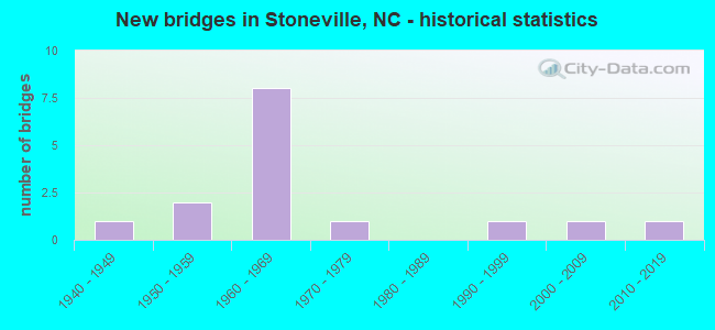
- New bridges - historical statistics
- 11940-1949
- 21950-1959
- 81960-1969
- 11970-1979
- 11990-1999
- 12000-2009
- 12010-2019

- Reconstructed bridges - Historical Statistics
- 11950-1959
- 01960-1969
- 21970-1979
- 01980-1989
- 11990-1999


- Bridge Condition - Deck
- 12.5%Very good
- 12.5%Good
- 50.0%Satisfactory
- 12.5%Fair
- 12.5%Poor

- Bridge Condition - Superstructure
- 12.5%Very good
- 37.5%Satisfactory
- 25.0%Fair
- 12.5%Poor
- 12.5%Serious

- Bridge Condition - Substructure
- 12.5%Very good
- 25.0%Satisfactory
- 25.0%Fair
- 37.5%Poor

- Bridge Condition - Channel
- 55.6%Good
- 33.3%Satisfactory
- 11.1%Fair

- Bridge Condition - Culverts
- 33.3%Good
- 66.7%Satisfactory
Find on map >> Show street view
Structure Number: 1570069, Location: 1.4 MI. W. JCT. US220BUS. (Lat: 36.467358, Lng: -79.926525), Route carried "on" structure: State highway 770, Year Built: 1962, Status: Posted for load, Structure Length: 7.34m (24.08ft), Average Daily Traffic: 3,300 (year 2018), Truck Traffic: 7%, Average Future Daily Traffic: 6,600 (year 2040), Design Load: HS 15, Features Intersected: US220
Minimum Vertical Clearance: 30+ m (98+ ft), Kilometerpoint: 0.000, Lanes on structure: 2, Lanes under structure: 4, Owner: State Highway Agency, Approaching Roadway Width: 7.3m (24.0ft), Skew: 3 degrees, Material/Design: Steel, Design/Construction: Stringer/Multi-beam, Number Of Spans In Main Unit: 4, Length of Maximum Span: 21.0m (68.9ft), Curb or Sidewalk Widths: Left: 0.4m (1.3ft), Right: 0.4m (1.3ft), Curb-To-Curb Width: 8.5m (27.9ft), Out-to-Out Width: 10.1m (33.1ft)
Condition: Deck: Fair, Superstructure: Poor, Substructure: Poor, Operating Rating: 20.8 metric tons, Method Used To Determine Operating Rating: Load Factor (LF), Inventory Rating: 11.7 metric tons, Method Used To Determine Inventory Rating: Load Factor (LF), Structural Evaluation: High priority of replacement, Deck Geometry: Meets minimum limits, Underclear: High priority of replacement, Approach Roadway Alignment: Equal to present desirable criteria, Bridge Posting: Required (Relationship of Operating Rating to Maximum Legal Load: > 39.9% below), Designated Inspection Frequency: Every 24 months, Inspection Date: September 2021, Deck Structure Type: Concrete Cast-file-Place, Wearing Surface/Protective System: Wearing Surface: Bituminous
Find on map >> Show street view
Structure Number: 1570105, Location: 0.10 MI.W.JCT.SR2221 (Lat: 36.472358, Lng: -79.806678), Route carried "on" structure: US 311, Year Built: 1968, Status: Open, Structure Length: 3.68m (12.07ft), Average Daily Traffic: 7,200 (year 2015), Truck Traffic: 6%, Average Future Daily Traffic: 14,400 (year 2040), Design Load: HS 20+Mod, Features Intersected: BUFFALO CREEK
Minimum Vertical Clearance: 30+ m (98+ ft), Kilometerpoint: 0.000, Lanes on structure: 2, Owner: State Highway Agency, Approaching Roadway Width: 8.5m (27.9ft), Skew: 1 degrees, Material/Design: Prestressed concrete, Design/Construction: Stringer/Multi-beam, Number Of Spans In Main Unit: 3, Length of Maximum Span: 11.5m (37.7ft), Curb-To-Curb Width: 9.7m (31.8ft), Out-to-Out Width: 11.1m (36.4ft)
Condition: Deck: Good, Superstructure: Fair, Substructure: Satisfactory, Channel: Good, Operating Rating: 81.6 metric tons, Method Used To Determine Operating Rating: Load Factor (LF), Inventory Rating: 42.6 metric tons, Method Used To Determine Inventory Rating: Load Factor (LF), Structural Evaluation: Somewhat better than minimum adequacy, Deck Geometry: High priority of corrective action, Waterway Adequacy: Better than present minimum criteria, Approach Roadway Alignment: Equal to present desirable criteria, Designated Inspection Frequency: Every 24 months, Inspection Date: June 2021, Deck Structure Type: Concrete Cast-file-Place, Wearing Surface/Protective System: Wearing Surface: Bituminous
Find on map >> Show street view
Structure Number: 1570136, Location: 0.2 MI. N. JCT. SR2155 (Lat: 36.450089, Lng: -79.900700), Route carried "on" structure: State highway 2154, Year Built: 1997, Status: Open, Structure Length: 0.64m (2.10ft), Average Daily Traffic: 550 (year 2016), Truck Traffic: 6%, Average Future Daily Traffic: 1,100 (year 2040), Design Load: HS 20+Mod, Features Intersected: BRANCH OF MAYO RIVER
Minimum Vertical Clearance: 30+ m (98+ ft), Kilometerpoint: 0.000, Lanes on structure: 2, Owner: State Highway Agency, Approaching Roadway Width: 5.4m (17.7ft), Material/Design: Steel, Design/Construction: Culvert, Number Of Spans In Main Unit: 2, Length of Maximum Span: 2.7m (8.9ft)
Condition: Channel: Good, Culverts: Satisfactory, Operating Rating: 89.8 metric tons, Method Used To Determine Operating Rating: Load and Resistance Factor (LRFR), Inventory Rating: 73.4 metric tons, Method Used To Determine Inventory Rating: Load and Resistance Factor (LRFR), Structural Evaluation: Equal to present minimum criteria, Waterway Adequacy: Better than present minimum criteria, Approach Roadway Alignment: Equal to present desirable criteria, Designated Inspection Frequency: Every 24 months, Inspection Date: July 2021
Find on map >> Show street view
Structure Number: 1570165, Location: 1.7 MI. N. JCT. SR1360 (Lat: 36.513864, Lng: -79.945819), Route carried "on" structure: State highway 1376, Year Built: 2008, Status: Open, Structure Length: 0.64m (2.10ft), Average Daily Traffic: 190 (year 2016), Truck Traffic: 6%, Average Future Daily Traffic: 380 (year 2040), Design Load: HS 20+Mod, Features Intersected: BRANCH OF PAW PAW CREEK
Minimum Vertical Clearance: 30+ m (98+ ft), Kilometerpoint: 0.000, Lanes on structure: 1, Owner: State Highway Agency, Approaching Roadway Width: 4.2m (13.8ft), Skew: 1 degrees, Material/Design: Concrete continuous, Design/Construction: Culvert, Number Of Spans In Main Unit: 2, Length of Maximum Span: 3.0m (9.8ft)
Condition: Channel: Good, Culverts: Good, Operating Rating: 62.5 metric tons, Method Used To Determine Operating Rating: Load and Resistance Factor (LRFR), Inventory Rating: 48.0 metric tons, Method Used To Determine Inventory Rating: Load and Resistance Factor (LRFR), Structural Evaluation: Better than present minimum criteria, Waterway Adequacy: Better than present minimum criteria, Approach Roadway Alignment: Equal to present desirable criteria, Designated Inspection Frequency: Every 24 months, Inspection Date: September 2020
Find on map >> Show street view
Structure Number: 1570166, Location: 0.1 MI. S. JCT. SR1382 (Lat: 36.504686, Lng: -79.962611), Route carried "on" structure: State highway 1360, Year Built: 1948, Year Reconstructed: 1982, Status: Temporarily open, Structure Length: 1.21m (3.97ft), Average Daily Traffic: 710 (year 2016), Truck Traffic: 6%, Average Future Daily Traffic: 1,420 (year 2040), Features Intersected: PRONG PAW PAW CREEK
Minimum Vertical Clearance: 30+ m (98+ ft), Kilometerpoint: 0.000, Lanes on structure: 2, Owner: State Highway Agency, Approaching Roadway Width: 5.4m (17.7ft), Material/Design: Steel, Design/Construction: Stringer/Multi-beam, Number Of Spans In Main Unit: 1, Length of Maximum Span: 11.8m (38.7ft), Curb-To-Curb Width: 7.2m (23.6ft), Out-to-Out Width: 7.6m (24.9ft)
Condition: Deck: Satisfactory, Superstructure: Fair, Substructure: Poor, Channel: Satisfactory, Operating Rating: 52.6 metric tons, Method Used To Determine Operating Rating: Load Factor (LF), Inventory Rating: 31.7 metric tons, Method Used To Determine Inventory Rating: Load Factor (LF), Structural Evaluation: Meets minimum limits, Deck Geometry: Meets minimum limits, Waterway Adequacy: Better than present minimum criteria, Approach Roadway Alignment: Equal to present minimum criteria, Designated Inspection Frequency: Every 24 months, Inspection Date: October 2020, Deck Structure Type: Corrugated Steel, Wearing Surface/Protective System: Wearing Surface: Bituminous
Find on map >> Show street view
Structure Number: 1570167, Location: 0.4 MI.E.JCT.MAIN STREET (Lat: 36.464283, Lng: -79.920994), Route carried "on" structure: City street , Year Built: 1955, Year Reconstructed: 1961, Status: Posted for load, Structure Length: 0.91m (2.99ft), Average Daily Traffic: 400 (year 1991), Truck Traffic: 7%, Average Future Daily Traffic: 800 (year 2040), Design Load: HS 20+Mod, Features Intersected: PRONG OF MAYO RIVER, Facility Carried by Structure: BRYAN ST.
Minimum Vertical Clearance: 30+ m (98+ ft), Kilometerpoint: 0.000, Lanes on structure: 2, Owner: City or Municipal Highway Agency, Approaching Roadway Width: 7.0m (23.0ft), Material/Design: Steel, Design/Construction: Stringer/Multi-beam, Number Of Spans In Main Unit: 1, Length of Maximum Span: 8.8m (28.9ft), Curb or Sidewalk Widths: Left: 0.1m (0.3ft), Right: 0.1m (0.3ft), Curb-To-Curb Width: 7.3m (24.0ft), Out-to-Out Width: 8.1m (26.6ft)
Condition: Deck: Satisfactory, Superstructure: Satisfactory, Substructure: Fair, Channel: Fair, Operating Rating: 22.6 metric tons, Method Used To Determine Operating Rating: Load Factor (LF), Inventory Rating: 12.7 metric tons, Method Used To Determine Inventory Rating: Load Factor (LF), Structural Evaluation: Meets minimum limits, Deck Geometry: Somewhat better than minimum adequacy, Waterway Adequacy: Equal to present minimum criteria, Approach Roadway Alignment: Equal to present desirable criteria, Bridge Posting: Required (Relationship of Operating Rating to Maximum Legal Load: > 39.9% below), Designated Inspection Frequency: Every 24 months, Inspection Date: March 2020, Deck Structure Type: Concrete Cast-file-Place, Wearing Surface/Protective System: Wearing Surface: Bituminous
Find on map >> Show street view
Structure Number: 157017, Location: 0.25 MI. N. JCT. SR1376 (Lat: 36.502183, Lng: -79.921442), Route carried "on" structure: State highway 1360, Year Built: 1962, Status: Open, Structure Length: 6.46m (21.19ft), Average Daily Traffic: 740 (year 2018), Truck Traffic: 6%, Average Future Daily Traffic: 1,480 (year 2040), Design Load: HS 15, Features Intersected: US220
Minimum Vertical Clearance: 30+ m (98+ ft), Kilometerpoint: 0.000, Lanes on structure: 2, Lanes under structure: 4, Owner: State Highway Agency, Approaching Roadway Width: 7.6m (24.9ft), Skew: 2 degrees, Material/Design: Prestressed concrete, Design/Construction: Stringer/Multi-beam, Number Of Spans In Main Unit: 4, Length of Maximum Span: 18.2m (59.7ft), Curb or Sidewalk Widths: Left: 0.4m (1.3ft), Right: 0.4m (1.3ft), Curb-To-Curb Width: 8.5m (27.9ft), Out-to-Out Width: 10.1m (33.1ft)
Condition: Deck: Satisfactory, Superstructure: Serious, Substructure: Poor, Operating Rating: 55.3 metric tons, Method Used To Determine Operating Rating: Load Factor (LF), Inventory Rating: 18.1 metric tons, Method Used To Determine Inventory Rating: Load Factor (LF), Structural Evaluation: High priority of corrective action, Deck Geometry: Somewhat better than minimum adequacy, Underclear: Meets minimum limits, Approach Roadway Alignment: Equal to present desirable criteria, Designated Inspection Frequency: Every 24 months, Inspection Date: July 2021, Deck Structure Type: Concrete Cast-file-Place, Wearing Surface/Protective System: Wearing Surface: Monolithic Concrete
Find on map >> Show street view
Structure Number: 1570171, Location: 75FT. S. OF JCT. SR1509 (Lat: 36.499681, Lng: -79.871036), Route carried "on" structure: State highway 1515, Year Built: 2017, Status: Open, Structure Length: 2.68m (8.79ft), Average Daily Traffic: 490 (year 2015), Truck Traffic: 6%, Average Future Daily Traffic: 980 (year 2040), Design Load: HL 93, Features Intersected: BUFFALO CREEK
Minimum Vertical Clearance: 30+ m (98+ ft), Kilometerpoint: 0.000, Lanes on structure: 2, Owner: State Highway Agency, Approaching Roadway Width: 9.1m (29.9ft), Skew: 3 degrees, Material/Design: Prestressed concrete, Design/Construction: Box Beam or Girders - Multiple, Number Of Spans In Main Unit: 1, Length of Maximum Span: 25.6m (84.0ft), Curb-To-Curb Width: 9.0m (29.5ft), Out-to-Out Width: 10.0m (32.8ft)
Condition: Deck: Very good, Superstructure: Very good, Substructure: Very good, Channel: Good, Operating Rating: 60.7 metric tons, Method Used To Determine Operating Rating: Load and Resistance Factor (LRFR), Inventory Rating: 47.1 metric tons, Method Used To Determine Inventory Rating: Load and Resistance Factor (LRFR), Structural Evaluation: Equal to present desirable criteria, Deck Geometry: Somewhat better than minimum adequacy, Waterway Adequacy: Better than present minimum criteria, Approach Roadway Alignment: Equal to present desirable criteria, Designated Inspection Frequency: Every 24 months, Inspection Date: October 2020, Deck Structure Type: Concrete Precast Panels, Wearing Surface/Protective System: Wearing Surface: Bituminous
Find on map >> Show street view
Structure Number: 1570172, Location: 0.05 MI. W. JCT. SR1508 (Lat: 36.504050, Lng: -79.873272), Route carried "on" structure: State highway 1509, Year Built: 1957, Year Reconstructed: 1984, Status: Posted for load, Structure Length: 1.06m (3.48ft), Average Daily Traffic: 190 (year 2000), Truck Traffic: 6%, Average Future Daily Traffic: 380 (year 2040), Features Intersected: BUFFALO CREEK
Minimum Vertical Clearance: 30+ m (98+ ft), Kilometerpoint: 0.000, Lanes on structure: 2, Owner: State Highway Agency, Approaching Roadway Width: 5.4m (17.7ft), Material/Design: Wood or Timber, Design/Construction: Stringer/Multi-beam, Number Of Spans In Main Unit: 2, Length of Maximum Span: 5.1m (16.7ft), Curb or Sidewalk Widths: Left: 0.1m (0.3ft), Right: 0.1m (0.3ft), Curb-To-Curb Width: 6.0m (19.7ft), Out-to-Out Width: 6.4m (21.0ft)
Condition: Deck: Poor, Superstructure: Satisfactory, Substructure: Fair, Channel: Satisfactory, Operating Rating: 28.1 metric tons, Method Used To Determine Operating Rating: Allowable Stress (AS), Inventory Rating: 19.9 metric tons, Method Used To Determine Inventory Rating: Allowable Stress (AS), Structural Evaluation: Somewhat better than minimum adequacy, Deck Geometry: High priority of corrective action, Waterway Adequacy: Better than present minimum criteria, Approach Roadway Alignment: Equal to present minimum criteria, Bridge Posting: Required (Relationship of Operating Rating to Maximum Legal Load: 30.0 - 39.9% below), Designated Inspection Frequency: Every 24 months, Inspection Date: October 2020, Deck Structure Type: Wood or Timber, Wearing Surface/Protective System: Wearing Surface: Bituminous
Find on map >> Show street view
Structure Number: 1570175, Location: 0.08 MI. E. JCT. SR1522 (Lat: 36.490497, Lng: -79.854439), Route carried "on" structure: State highway 1516, Year Built: 1974, Status: Posted for load, Structure Length: 2.74m (8.99ft), Average Daily Traffic: 420 (year 2015), Truck Traffic: 6%, Average Future Daily Traffic: 840 (year 2040), Design Load: HS 15, Features Intersected: BUFFALO CREEK
Minimum Vertical Clearance: 30+ m (98+ ft), Kilometerpoint: 0.000, Lanes on structure: 2, Owner: State Highway Agency, Approaching Roadway Width: 6.4m (21.0ft), Material/Design: Prestressed concrete, Design/Construction: Channel Beam, Number Of Spans In Main Unit: 3, Length of Maximum Span: 8.8m (28.9ft), Curb or Sidewalk Widths: Left: 0.2m (0.7ft), Right: 0.2m (0.7ft), Curb-To-Curb Width: 8.7m (28.5ft), Out-to-Out Width: 9.2m (30.2ft)
Condition: Deck: Satisfactory, Superstructure: Satisfactory, Substructure: Satisfactory, Channel: Satisfactory, Operating Rating: 40.8 metric tons, Method Used To Determine Operating Rating: Load Factor (LF), Inventory Rating: 22.6 metric tons, Method Used To Determine Inventory Rating: Load Factor (LF), Structural Evaluation: Equal to present minimum criteria, Deck Geometry: Somewhat better than minimum adequacy, Waterway Adequacy: Better than present minimum criteria, Approach Roadway Alignment: Equal to present desirable criteria, Bridge Posting: Required (Relationship of Operating Rating to Maximum Legal Load: 0.1 - 9.9% below), Designated Inspection Frequency: Every 24 months, Inspection Date: October 2020, Deck Structure Type: Concrete Cast-file-Place, Wearing Surface/Protective System: Wearing Surface: Bituminous
Find on map >> Show street view
Structure Number: 1570294, Location: 0.7 MI. S. JCT. NC770 (Lat: 36.458192, Lng: -79.926453), Route carried "on" structure: US 220, Year Built: 1962, Year Reconstructed: 1997, Status: Open, Structure Length: 0.85m (2.79ft), Average Daily Traffic: 14,000 (year 2018), Truck Traffic: 14%, Average Future Daily Traffic: 28,000 (year 2025), Design Load: HS 20+Mod, Features Intersected: BRANCH OF MAYO RIVER
Minimum Vertical Clearance: 30+ m (98+ ft), Kilometerpoint: 4.450, Lanes on structure: 4, Base Highway Network: Yes (Inventory Route: 2, Subroute: 20), Owner: State Highway Agency, Approaching Roadway Width: 21.0m (68.9ft), Skew: 22 degrees, Material/Design: Concrete continuous, Design/Construction: Culvert, Number Of Spans In Main Unit: 3, Length of Maximum Span: 2.4m (7.9ft)
Condition: Channel: Good, Culverts: Satisfactory, Operating Rating: 41.7 metric tons, Method Used To Determine Operating Rating: Field evaluation and documented engineering judgment, Inventory Rating: 32.6 metric tons, Method Used To Determine Inventory Rating: Field evaluation and documented engineering judgment, Structural Evaluation: Equal to present minimum criteria, Waterway Adequacy: Better than present minimum criteria, Approach Roadway Alignment: Equal to present desirable criteria, Designated Inspection Frequency: Every 24 months, Inspection Date: July 2021
Find on map >> Show street view
Structure Number: 1570069, Location: 1.4 MI. W. JCT. US220BUS. (Lat: 36.467358, Lng: -79.926525), Route carried "under" structure: Bypass US 220, Year Built: 1962, Structure Length: 0. m, Average Daily Traffic: 3,300 (year 2018), Truck Traffic: 14%, Features Intersected: NC770
Minimum Vertical Clearance: 4.31m (14.14ft), Kilometerpoint: 0.000, Lanes on structure: 2, Lanes under structure: 2, Material/Design: Steel, Design/Construction: Stringer/Multi-beam, Length of Maximum Span: 21.0m (68.9ft)
Find on map >> Show street view
Structure Number: 1570069, Location: 1.4 MI. W. JCT. US220BUS. (Lat: 36.467358, Lng: -79.926525), Route carried "under" structure: Bypass US 220, Year Built: 1962, Structure Length: 0. m, Average Daily Traffic: 3,300 (year 2018), Truck Traffic: 14%, Features Intersected: NC770
Minimum Vertical Clearance: 4.36m (14.30ft), Kilometerpoint: 0.000, Lanes on structure: 2, Lanes under structure: 2, Material/Design: Steel, Design/Construction: Stringer/Multi-beam, Length of Maximum Span: 21.0m (68.9ft)
Find on map >> Show street view
Structure Number: 157017, Location: 0.25 MI. N. JCT. SR1376 (Lat: 36.502183, Lng: -79.921442), Route carried "under" structure: US 220, Year Built: 1962, Structure Length: 0. m, Average Daily Traffic: 5,000 (year 2015), Truck Traffic: 14%, Features Intersected: SR1360
Minimum Vertical Clearance: 4.59m (15.06ft), Kilometerpoint: 0.000, Lanes on structure: 2, Lanes under structure: 2, Material/Design: Prestressed concrete, Design/Construction: Stringer/Multi-beam, Length of Maximum Span: 18.2m (59.7ft)
Find on map >> Show street view
Structure Number: 157017, Location: 0.25 MI. N. JCT. SR1376 (Lat: 36.502183, Lng: -79.921442), Route carried "under" structure: US 220, Year Built: 1962, Structure Length: 0. m, Average Daily Traffic: 5,000 (year 2015), Truck Traffic: 14%, Features Intersected: SR1360
Minimum Vertical Clearance: 4.29m (14.07ft), Kilometerpoint: 0.000, Lanes on structure: 2, Lanes under structure: 2, Material/Design: Prestressed concrete, Design/Construction: Stringer/Multi-beam, Length of Maximum Span: 18.2m (59.7ft)