Bridge Statistics for Stonewall, Mississippi (MS)
Condition, Traffic, Stress, Structural Evaluation, Project Costs
- National Bridge Inventory (NBI) Statistics
- 14Number of bridges
- 135ft / 40.5mTotal length
- $603,081,000Total costs
- 17,518Total average daily traffic
- 1,466Total average daily truck traffic
- 19,671Total future (year 2038) average daily traffic
- National Bridge Inventory (NBI) Registered Bridges for Stonewall
- No street view available for this location
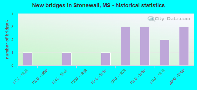
- New bridges - historical statistics
- 11920-1929
- 11940-1949
- 11960-1969
- 31970-1979
- 31980-1989
- 21990-1999
- 32000-2009


- Bridge Condition - Deck
- 75.0%Good
- 12.5%Satisfactory
- 12.5%Fair

- Bridge Condition - Superstructure
- 25.0%Very good
- 50.0%Good
- 12.5%Satisfactory
- 12.5%Fair

- Bridge Condition - Substructure
- 25.0%Very good
- 25.0%Satisfactory
- 37.5%Fair
- 12.5%Poor

- Bridge Condition - Channel
- 7.1%Very good
- 57.1%Good
- 35.7%Satisfactory
Find on map >> Show street view
Structure Number: 21000110121395, Location: 5.1 MI N SR 18 (Lat: 32.109517, Lng: -88.856917), Route carried "on" structure: US 11, Year Built: 1925, Year Reconstructed: 1937, Status: Open, Structure Length: 0.67m (2.20ft), Average Daily Traffic: 610 (year 2020), Truck Traffic: 11%, Average Future Daily Traffic: 610 (year 2040), Design Load: HS 15, Features Intersected: STREAM
Minimum Vertical Clearance: 30+ m (98+ ft), Kilometerpoint: 17.906, Lanes on structure: 2, Owner: State Highway Agency, Approaching Roadway Width: 7.9m (25.9ft), Material/Design: Concrete, Design/Construction: Culvert, Number Of Spans In Main Unit: 2, Length of Maximum Span: 3.0m (9.8ft)
Condition: Channel: Satisfactory, Culverts: Good, Operating Rating: 99.3 metric tons, Method Used To Determine Operating Rating: Load Factor (LF), Inventory Rating: 59.5 metric tons, Method Used To Determine Inventory Rating: Load Factor (LF), Structural Evaluation: Better than present minimum criteria, Waterway Adequacy: Equal to present minimum criteria, Approach Roadway Alignment: Equal to present desirable criteria, Designated Inspection Frequency: Every 24 months, Inspection Date: May 2021
Find on map >> Show street view
Structure Number: 31005130120077, Location: 3.7 MI E US 514 (Lat: 32.134039, Lng: -88.784769), Route carried "on" structure: State highway 513, Year Built: 1984, Status: Open, Structure Length: 1.74m (5.71ft), Average Daily Traffic: 3,400 (year 2020), Truck Traffic: 6%, Average Future Daily Traffic: 3,400 (year 2040), Design Load: HS 20, Features Intersected: STREAM
Minimum Vertical Clearance: 30+ m (98+ ft), Kilometerpoint: 12.009, Lanes on structure: 2, Owner: State Highway Agency, Approaching Roadway Width: 9.1m (29.9ft), Material/Design: Concrete, Design/Construction: Channel Beam, Number Of Spans In Main Unit: 3, Length of Maximum Span: 5.8m (19.0ft), Curb-To-Curb Width: 8.5m (27.9ft), Out-to-Out Width: 9.6m (31.5ft)
Condition: Deck: Good, Superstructure: Good, Substructure: Satisfactory, Channel: Satisfactory, Operating Rating: 50.5 metric tons, Method Used To Determine Operating Rating: Load Factor (LF), Inventory Rating: 30.3 metric tons, Method Used To Determine Inventory Rating: Load Factor (LF), Structural Evaluation: Equal to present minimum criteria, Deck Geometry: Meets minimum limits, Waterway Adequacy: Equal to present desirable criteria, Approach Roadway Alignment: Equal to present desirable criteria, Designated Inspection Frequency: Every 24 months, Other Special Inspection Frequency: Every 24 months, Inspection Date: April 2021, Other Special Inspection Date: April 2020, Deck Structure Type: Concrete Precast Panels
Find on map >> Show street view
Structure Number: 3100513012008, Location: 3.4 MI E SR 514 (Lat: 32.135450, Lng: -88.789711), Route carried "on" structure: State highway 513, Year Built: 1949, Status: Open, Structure Length: 1.34m (4.40ft), Average Daily Traffic: 3,400 (year 2020), Truck Traffic: 6%, Average Future Daily Traffic: 3,400 (year 2040), Design Load: H 15, Features Intersected: STREAM
Minimum Vertical Clearance: 30+ m (98+ ft), Kilometerpoint: 12.508, Lanes on structure: 2, Owner: State Highway Agency, Approaching Roadway Width: 7.9m (25.9ft), Material/Design: Concrete, Design/Construction: Culvert, Number Of Spans In Main Unit: 4, Length of Maximum Span: 3.0m (9.8ft)
Condition: Channel: Good, Culverts: Good, Operating Rating: 34.3 metric tons, Method Used To Determine Operating Rating: Load Factor (LF), Inventory Rating: 20.6 metric tons, Method Used To Determine Inventory Rating: Load Factor (LF), Structural Evaluation: Somewhat better than minimum adequacy, Waterway Adequacy: Equal to present desirable criteria, Approach Roadway Alignment: Equal to present desirable criteria, Length Of Structure Improvement: 1.34m (4.40ft), Designated Inspection Frequency: Every 24 months, Inspection Date: May 2021, Bridge Improvement Cost: $85,000,000, Roadway Improvement Cost: $200,000,000, Total Project Cost: $345,000,000
Find on map >> Show street view
Structure Number: 31005130120084, Location: 3.0 MI E SR 514 (Lat: 32.138731, Lng: -88.796500), Route carried "on" structure: State highway 513, Year Built: 1984, Status: Open, Structure Length: 1.16m (3.81ft), Average Daily Traffic: 2,100 (year 2020), Truck Traffic: 11%, Average Future Daily Traffic: 2,100 (year 2040), Design Load: HS 20, Features Intersected: STREAM
Minimum Vertical Clearance: 30+ m (98+ ft), Kilometerpoint: 13.245, Lanes on structure: 2, Owner: State Highway Agency, Approaching Roadway Width: 8.5m (27.9ft), Material/Design: Concrete, Design/Construction: Channel Beam, Number Of Spans In Main Unit: 2, Length of Maximum Span: 5.8m (19.0ft), Curb-To-Curb Width: 8.5m (27.9ft), Out-to-Out Width: 9.6m (31.5ft)
Condition: Deck: Good, Superstructure: Good, Substructure: Fair, Channel: Good, Operating Rating: 50.5 metric tons, Method Used To Determine Operating Rating: Load Factor (LF), Inventory Rating: 30.3 metric tons, Method Used To Determine Inventory Rating: Load Factor (LF), Structural Evaluation: Somewhat better than minimum adequacy, Deck Geometry: Meets minimum limits, Waterway Adequacy: Equal to present desirable criteria, Approach Roadway Alignment: Equal to present desirable criteria, Length Of Structure Improvement: 1.16m (3.81ft), Designated Inspection Frequency: Every 24 months, Other Special Inspection Frequency: Every 24 months, Inspection Date: April 2021, Other Special Inspection Date: April 2020, Bridge Improvement Cost: $19,000,000, Roadway Improvement Cost: $200,000,000, Total Project Cost: $254,000,000, Deck Structure Type: Concrete Precast Panels, Wearing Surface/Protective System: Wearing Surface: Bituminous
Find on map >> Show street view
Structure Number: 31005130120098, Location: 1.6 MI S SR 514 (Lat: 32.155750, Lng: -88.806819), Route carried "on" structure: State highway 513, Year Built: 1990, Status: Open, Structure Length: 0.70m (2.30ft), Average Daily Traffic: 2,300 (year 2020), Truck Traffic: 11%, Average Future Daily Traffic: 2,300 (year 2040), Design Load: HS 20+Mod, Features Intersected: WATERMILL DAM
Minimum Vertical Clearance: 30+ m (98+ ft), Kilometerpoint: 15.432, Lanes on structure: 2, Owner: State Highway Agency, Approaching Roadway Width: 12.2m (40.0ft), Skew: 1 degrees, Material/Design: Concrete, Design/Construction: Culvert, Number Of Spans In Main Unit: 2, Length of Maximum Span: 3.0m (9.8ft)
Condition: Channel: Very good, Culverts: Good, Inventory Rating: 99.8 metric tons, Method Used To Determine Inventory Rating: Load Factor (LF), Structural Evaluation: Better than present minimum criteria, Waterway Adequacy: Equal to present desirable criteria, Approach Roadway Alignment: Equal to present desirable criteria, Designated Inspection Frequency: Every 24 months, Inspection Date: May 2021
Find on map >> Show street view
Structure Number: 3100514012004, Location: 4.0 MI E SR 513 (Lat: 32.170669, Lng: -88.747733), Route carried "on" structure: State highway 514, Year Built: 1965, Status: Open, Structure Length: 1.37m (4.49ft), Average Daily Traffic: 1,400 (year 2020), Truck Traffic: 11%, Average Future Daily Traffic: 1,400 (year 2040), Design Load: H 15, Features Intersected: STREAM
Minimum Vertical Clearance: 30+ m (98+ ft), Kilometerpoint: 6.497, Lanes on structure: 2, Owner: State Highway Agency, Approaching Roadway Width: 9.1m (29.9ft), Skew: 3 degrees, Material/Design: Concrete, Design/Construction: Culvert, Number Of Spans In Main Unit: 2, Length of Maximum Span: 5.5m (18.0ft)
Condition: Channel: Good, Culverts: Good, Operating Rating: 41.9 metric tons, Method Used To Determine Operating Rating: Load Factor (LF), Inventory Rating: 25.0 metric tons, Method Used To Determine Inventory Rating: Load Factor (LF), Structural Evaluation: Equal to present minimum criteria, Waterway Adequacy: Better than present minimum criteria, Approach Roadway Alignment: Equal to present desirable criteria, Designated Inspection Frequency: Every 24 months, Inspection Date: May 2021
Find on map >> Show street view
Structure Number: SA1200000000076, Location: SEC 1 T 3N R14E B (Lat: 32.130253, Lng: -88.811853), Route carried "on" structure: County highway 1331, Year Built: 1980, Status: Open, Structure Length: 13.32m (43.70ft), Average Daily Traffic: 1,368 (year 2022), Truck Traffic: 8%, Average Future Daily Traffic: 2,051 (year 2042), Design Load: HS 20, Features Intersected: CHICKASAWHAY RIVER, Facility Carried by Structure: RIVER ROAD
Minimum Vertical Clearance: 30+ m (98+ ft), Kilometerpoint: 21.726, Lanes on structure: 2, Owner: City or Municipal Highway Agency, Approaching Roadway Width: 8.5m (27.9ft), Material/Design: Steel continuous, Design/Construction: Stringer/Multi-beam, Number Of Spans In Main Unit: 3, Number Of Approach Spans: 2, Length of Maximum Span: 45.7m (149.9ft), Curb or Sidewalk Widths: Left: 0.4m (1.3ft), Right: 0.4m (1.3ft), Curb-To-Curb Width: 8.5m (27.9ft), Out-to-Out Width: 9.4m (30.8ft)
Condition: Deck: Fair, Superstructure: Fair, Substructure: Fair, Channel: Good, Operating Rating: 48.3 metric tons, Method Used To Determine Operating Rating: Load Factor (LF), Inventory Rating: 28.9 metric tons, Method Used To Determine Inventory Rating: Load Factor (LF), Structural Evaluation: Somewhat better than minimum adequacy, Deck Geometry: Somewhat better than minimum adequacy, Waterway Adequacy: Equal to present desirable criteria, Approach Roadway Alignment: Better than present minimum criteria, Length Of Structure Improvement: 15.00m (49.21ft), Designated Inspection Frequency: Every 24 months, Inspection Date: November 2021, Bridge Improvement Cost: $2,700,000, Roadway Improvement Cost: $300,000, Total Project Cost: $3,000,000 ( Estimate for 2022), Deck Structure Type: Concrete Cast-file-Place, Wearing Surface/Protective System: Wearing Surface: Monolithic Concrete
Find on map >> Show street view
Structure Number: SA1200000000077, Location: SEC 10 T 3N R14E B (Lat: 32.112111, Lng: -88.858558), Route carried "on" structure: County highway 172, Year Built: 1976, Status: Open, Structure Length: 1.74m (5.71ft), Average Daily Traffic: 140 (year 2021), Truck Traffic: 8%, Average Future Daily Traffic: 210 (year 2041), Design Load: H 15, Features Intersected: GORDON CREEK, Facility Carried by Structure: CO RD 330
Minimum Vertical Clearance: 30+ m (98+ ft), Kilometerpoint: 9.816, Lanes on structure: 2, Owner: County Highway Agency, Approaching Roadway Width: 6.5m (21.3ft), Material/Design: Concrete, Design/Construction: Channel Beam, Number Of Spans In Main Unit: 3, Length of Maximum Span: 5.8m (19.0ft), Curb or Sidewalk Widths: Left: 0.2m (0.7ft), Right: 0.2m (0.7ft), Curb-To-Curb Width: 8.2m (26.9ft), Out-to-Out Width: 8.6m (28.2ft)
Condition: Deck: Satisfactory, Superstructure: Satisfactory, Substructure: Fair, Channel: Satisfactory, Operating Rating: 44.3 metric tons, Method Used To Determine Operating Rating: Load Factor (LF), Inventory Rating: 26.5 metric tons, Method Used To Determine Inventory Rating: Load Factor (LF), Structural Evaluation: Somewhat better than minimum adequacy, Deck Geometry: Somewhat better than minimum adequacy, Waterway Adequacy: Equal to present desirable criteria, Approach Roadway Alignment: Equal to present minimum criteria, Length Of Structure Improvement: 2.38m (7.81ft), Designated Inspection Frequency: Every 24 months, Inspection Date: October 2020, Bridge Improvement Cost: $142,000, Roadway Improvement Cost: $15,000, Total Project Cost: $175,000 ( Estimate for 2015), Deck Structure Type: Concrete Precast Panels, Wearing Surface/Protective System: Wearing Surface: Monolithic Concrete
Find on map >> Show street view
Structure Number: SA1200000000078, Location: SEC 12 T 3N R14E B (Lat: 32.114028, Lng: -88.816361), Route carried "on" structure: County highway 1331, Year Built: 2009, Status: Open, Structure Length: 6.71m (22.01ft), Average Daily Traffic: 560 (year 2021), Truck Traffic: 10%, Average Future Daily Traffic: 840 (year 2041), Design Load: HS 20, Features Intersected: MCCANTS CREEK, Facility Carried by Structure: CO RD 320
Minimum Vertical Clearance: 30+ m (98+ ft), Kilometerpoint: 18.990, Lanes on structure: 2, Owner: County Highway Agency, Approaching Roadway Width: 7.3m (24.0ft), Material/Design: Prestressed concrete, Design/Construction: Stringer/Multi-beam, Number Of Spans In Main Unit: 5, Length of Maximum Span: 18.3m (60.0ft), Curb or Sidewalk Widths: Left: 0.5m (1.6ft), Right: 0.5m (1.6ft), Curb-To-Curb Width: 9.1m (29.9ft), Out-to-Out Width: 10.1m (33.1ft)
Condition: Deck: Good, Superstructure: Very good, Substructure: Very good, Channel: Good, Operating Rating: 57.2 metric tons, Method Used To Determine Operating Rating: Load Factor (LF), Inventory Rating: 32.4 metric tons, Method Used To Determine Inventory Rating: Load Factor (LF), Structural Evaluation: Equal to present desirable criteria, Deck Geometry: Equal to present minimum criteria, Waterway Adequacy: Equal to present desirable criteria, Approach Roadway Alignment: Equal to present desirable criteria, Designated Inspection Frequency: Every 24 months, Inspection Date: December 2021, Deck Structure Type: Concrete Cast-file-Place, Wearing Surface/Protective System: Wearing Surface: Monolithic Concrete
Find on map >> Show street view
Structure Number: SA1200000000079, Location: SEC 13 T 3N R14E B (Lat: 32.106556, Lng: -88.818806), Route carried "on" structure: County highway 1331, Year Built: 2009, Status: Open, Structure Length: 4.27m (14.01ft), Average Daily Traffic: 150 (year 2021), Truck Traffic: 8%, Average Future Daily Traffic: 225 (year 2041), Design Load: HS 20, Features Intersected: BR OF CHICKASAWHAY RIVER, Facility Carried by Structure: CO RD 320
Minimum Vertical Clearance: 30+ m (98+ ft), Kilometerpoint: 18.346, Lanes on structure: 2, Owner: County Highway Agency, Approaching Roadway Width: 7.3m (24.0ft), Material/Design: Prestressed concrete, Design/Construction: Stringer/Multi-beam, Number Of Spans In Main Unit: 3, Length of Maximum Span: 18.3m (60.0ft), Curb or Sidewalk Widths: Left: 0.5m (1.6ft), Right: 0.5m (1.6ft), Curb-To-Curb Width: 8.5m (27.9ft), Out-to-Out Width: 9.5m (31.2ft)
Condition: Deck: Good, Superstructure: Very good, Substructure: Very good, Channel: Good, Operating Rating: 64.7 metric tons, Method Used To Determine Operating Rating: Load Factor (LF), Inventory Rating: 38.9 metric tons, Method Used To Determine Inventory Rating: Load Factor (LF), Structural Evaluation: Equal to present desirable criteria, Deck Geometry: Equal to present minimum criteria, Waterway Adequacy: Equal to present desirable criteria, Approach Roadway Alignment: Equal to present desirable criteria, Designated Inspection Frequency: Every 24 months, Inspection Date: December 2021, Deck Structure Type: Concrete Cast-file-Place, Wearing Surface/Protective System: Wearing Surface: Monolithic Concrete
Find on map >> Show street view
Structure Number: SA1200000000084, Location: SEC 2 T 3N R15E B (Lat: 32.134278, Lng: -88.730667), Route carried "on" structure: County highway 985, Year Built: 2004, Status: Open, Structure Length: 0.79m (2.59ft), Average Daily Traffic: 250 (year 2018), Truck Traffic: 8%, Average Future Daily Traffic: 375 (year 2038), Design Load: HS 20, Features Intersected: BR OF ARCHUSA CREEK, Facility Carried by Structure: CO RD 150
Minimum Vertical Clearance: 30+ m (98+ ft), Kilometerpoint: 4.506, Lanes on structure: 2, Owner: County Highway Agency, Approaching Roadway Width: 7.0m (23.0ft), Material/Design: Concrete, Design/Construction: Culvert, Number Of Spans In Main Unit: 2, Length of Maximum Span: 3.6m (11.8ft)
Condition: Channel: Good, Culverts: Good, Operating Rating: 65.7 metric tons, Method Used To Determine Operating Rating: Load Factor (LF), Inventory Rating: 39.2 metric tons, Method Used To Determine Inventory Rating: Load Factor (LF), Structural Evaluation: Better than present minimum criteria, Waterway Adequacy: Equal to present desirable criteria, Approach Roadway Alignment: Equal to present desirable criteria, Designated Inspection Frequency: Every 24 months, Inspection Date: Febuary 2020
Find on map >> Show street view
Structure Number: SA1200000000085, Location: SEC 3 T 3N R15E B (Lat: 32.129489, Lng: -88.746819), Route carried "on" structure: County highway 146, Year Built: 1976, Status: Open, Structure Length: 2.90m (9.51ft), Average Daily Traffic: 220 (year 2018), Truck Traffic: 8%, Average Future Daily Traffic: 330 (year 2038), Design Load: H 15, Features Intersected: ARCHUSA CREEK, Facility Carried by Structure: CO RD 160
Minimum Vertical Clearance: 30+ m (98+ ft), Kilometerpoint: 0.965, Lanes on structure: 2, Owner: County Highway Agency, Approaching Roadway Width: 6.1m (20.0ft), Material/Design: Concrete, Design/Construction: Channel Beam, Number Of Spans In Main Unit: 5, Length of Maximum Span: 5.8m (19.0ft), Curb or Sidewalk Widths: Left: 0.2m (0.7ft), Right: 0.2m (0.7ft), Curb-To-Curb Width: 8.1m (26.6ft), Out-to-Out Width: 8.5m (27.9ft)
Condition: Deck: Good, Superstructure: Good, Substructure: Satisfactory, Channel: Satisfactory, Operating Rating: 45.8 metric tons, Method Used To Determine Operating Rating: Load Factor (LF), Inventory Rating: 27.4 metric tons, Method Used To Determine Inventory Rating: Load Factor (LF), Structural Evaluation: Equal to present minimum criteria, Deck Geometry: Somewhat better than minimum adequacy, Waterway Adequacy: Equal to present desirable criteria, Approach Roadway Alignment: Equal to present desirable criteria, Length Of Structure Improvement: 3.72m (12.20ft), Designated Inspection Frequency: Every 24 months, Inspection Date: October 2020, Bridge Improvement Cost: $222,000, Roadway Improvement Cost: $25,000, Total Project Cost: $276,000 ( Estimate for 2019), Deck Structure Type: Concrete Precast Panels, Wearing Surface/Protective System: Wearing Surface: Monolithic Concrete
Find on map >> Show street view
Structure Number: SA1200000000086, Location: SEC 3 T 3N R15E B (Lat: 32.138367, Lng: -88.754075), Route carried "on" structure: County highway 985, Year Built: 1975, Status: Open, Structure Length: 2.90m (9.51ft), Average Daily Traffic: 760 (year 2021), Truck Traffic: 8%, Average Future Daily Traffic: 1,140 (year 2041), Design Load: H 15, Features Intersected: ARCHUSA CREEK, Facility Carried by Structure: CO RD 150
Minimum Vertical Clearance: 30+ m (98+ ft), Kilometerpoint: 7.081, Lanes on structure: 2, Owner: County Highway Agency, Approaching Roadway Width: 7.3m (24.0ft), Material/Design: Concrete, Design/Construction: Channel Beam, Number Of Spans In Main Unit: 5, Length of Maximum Span: 5.8m (19.0ft), Curb or Sidewalk Widths: Left: 0.2m (0.7ft), Right: 0.2m (0.7ft), Curb-To-Curb Width: 8.2m (26.9ft), Out-to-Out Width: 8.6m (28.2ft)
Condition: Deck: Good, Superstructure: Good, Substructure: Poor, Channel: Good, Operating Rating: 41.3 metric tons, Method Used To Determine Operating Rating: Load Factor (LF), Inventory Rating: 24.8 metric tons, Method Used To Determine Inventory Rating: Load Factor (LF), Structural Evaluation: Meets minimum limits, Deck Geometry: Somewhat better than minimum adequacy, Waterway Adequacy: Equal to present desirable criteria, Approach Roadway Alignment: Equal to present desirable criteria, Length Of Structure Improvement: 3.11m (10.20ft), Designated Inspection Frequency: Every 12 months, Inspection Date: October 2021, Bridge Improvement Cost: $530,000, Roadway Improvement Cost: $100,000, Total Project Cost: $630,000 ( Estimate for 2021), Deck Structure Type: Concrete Precast Panels, Wearing Surface/Protective System: Wearing Surface: Monolithic Concrete
Find on map >> Show street view
Structure Number: SA1200000000087, Location: SEC 6 T 3N R15E B (Lat: 32.130611, Lng: -88.798861), Route carried "on" structure: County highway 1331, Year Built: 1990, Status: Open, Structure Length: 0.92m (3.02ft), Average Daily Traffic: 860 (year 2021), Truck Traffic: 8%, Average Future Daily Traffic: 1,290 (year 2041), Design Load: HS 20, Features Intersected: BR OF JOHNS BRANCH, Facility Carried by Structure: RIVER ROAD
Minimum Vertical Clearance: 30+ m (98+ ft), Kilometerpoint: 22.852, Lanes on structure: 2, Owner: City or Municipal Highway Agency, Approaching Roadway Width: 6.9m (22.6ft), Material/Design: Concrete, Design/Construction: Culvert, Number Of Spans In Main Unit: 2, Length of Maximum Span: 4.3m (14.1ft)
Condition: Channel: Satisfactory, Culverts: Good, Operating Rating: 47.4 metric tons, Method Used To Determine Operating Rating: Load Factor (LF), Inventory Rating: 28.5 metric tons, Method Used To Determine Inventory Rating: Load Factor (LF), Structural Evaluation: Better than present minimum criteria, Waterway Adequacy: Equal to present desirable criteria, Approach Roadway Alignment: Equal to present desirable criteria, Designated Inspection Frequency: Every 24 months, Inspection Date: December 2021