Bridge Statistics for Strong City, Kansas (KS)
Condition, Traffic, Stress, Structural Evaluation, Project Costs
- National Bridge Inventory (NBI) Statistics
- 12Number of bridges
- 125ft / 37.8mTotal length
- $460,000Total costs
- 22,534Total average daily traffic
- 8,507Total average daily truck traffic
- National Bridge Inventory (NBI) Registered Bridges for Strong City
- No street view available for this location
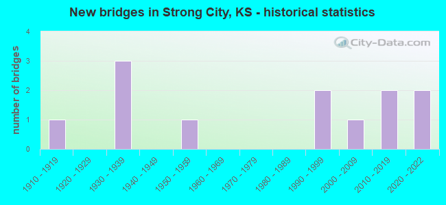
- New bridges - historical statistics
- 11910-1919
- 31930-1939
- 11950-1959
- 21990-1999
- 12000-2009
- 22010-2019
- 22020-2022


- Bridge Condition - Deck
- 37.5%Very good
- 25.0%Good
- 12.5%Satisfactory
- 25.0%Fair

- Bridge Condition - Superstructure
- 75.0%Very good
- 12.5%Satisfactory
- 12.5%Fair

- Bridge Condition - Substructure
- 75.0%Very good
- 12.5%Satisfactory
- 12.5%Fair

- Bridge Condition - Channel
- 30.0%Very good
- 30.0%Good
- 10.0%Satisfactory
- 30.0%Fair

- Bridge Condition - Culverts
- 33.3%Good
- 66.7%Satisfactory
Find on map >> Show street view
Structure Number: 9039, Location: 0.5S 2.8E OF STRONG CITY (Lat: 38.391367, Lng: -96.487967), Route carried "on" structure: County highway 856, Year Built: 2005, Status: Open, Structure Length: 3.69m (12.11ft), Average Daily Traffic: 80 (year 2014), Average Future Daily Traffic: 96 (year 2039), Design Load: HS 20, Features Intersected: STOUT CREEK
Minimum Vertical Clearance: 30.47m (99.97ft), Kilometerpoint: 0.000, Lanes on structure: 2, Owner: County Highway Agency, Approaching Roadway Width: 8.5m (27.9ft), Material/Design: Concrete continuous, Design/Construction: Slab, Number Of Spans In Main Unit: 3, Length of Maximum Span: 14.4m (47.2ft), Curb-To-Curb Width: 8.6m (28.2ft), Out-to-Out Width: 9.1m (29.9ft)
Condition: Deck: Very good, Superstructure: Very good, Substructure: Very good, Channel: Good, Operating Rating: 68.4 metric tons, Method Used To Determine Operating Rating: Load Factor (LF), Inventory Rating: 40.9 metric tons, Method Used To Determine Inventory Rating: Load Factor (LF), Structural Evaluation: Equal to present desirable criteria, Deck Geometry: Better than present minimum criteria, Waterway Adequacy: Equal to present desirable criteria, Approach Roadway Alignment: Somewhat better than minimum adequacy, Designated Inspection Frequency: Every 24 months, Inspection Date: March 2020, Other Special Inspection Date: November 2019, Deck Structure Type: Concrete Cast-file-Place
Find on map >> Show street view
Structure Number: 90903305202, Location: 0.6W OF STRONG CITY (Lat: 38.402186, Lng: -96.548833), Route carried "on" structure: County highway , Year Built: 1918, Status: Posted for load, Structure Length: 1.68m (5.51ft), Average Daily Traffic: 45 (year 2014), Average Future Daily Traffic: 54 (year 2039), Features Intersected: FOX CREEK, Facility Carried by Structure: 9.2-0.3 LOCAL RD.
Minimum Vertical Clearance: 30.47m (99.97ft), Kilometerpoint: 0.000, Lanes on structure: 1, Owner: County Highway Agency, Approaching Roadway Width: 6.0m (19.7ft), Material/Design: Masonry, Design/Construction: Arch - Deck, Number Of Spans In Main Unit: 1, Length of Maximum Span: 12.2m (40.0ft), Curb-To-Curb Width: 4.7m (15.4ft), Out-to-Out Width: 6.3m (20.7ft)
Condition: Deck: Fair, Superstructure: Fair, Substructure: Fair, Channel: Fair, Operating Rating: 20.7 metric tons, Method Used To Determine Operating Rating: Allowable Stress (AS), Inventory Rating: 16.2 metric tons, Method Used To Determine Inventory Rating: Allowable Stress (AS), Structural Evaluation: Somewhat better than minimum adequacy, Deck Geometry: Better than present minimum criteria, Waterway Adequacy: Better than present minimum criteria, Approach Roadway Alignment: Equal to present minimum criteria, Length Of Structure Improvement: 3.99m (13.09ft), Designated Inspection Frequency: Every 24 months, Inspection Date: March 2020, Bridge Improvement Cost: $350,000, Roadway Improvement Cost: $110,000, Total Project Cost: $460,000 ( Estimate for 2016), Deck Structure Type: Other, Wearing Surface/Protective System: Wearing Surface: Gravel
Find on map >> Show street view
Structure Number: 90907805225, Location: 1.2E OF STRONG CITY (Lat: 38.384214, Lng: -96.505333), Route carried "on" structure: County highway 920, Year Built: 1935, Status: Open, Structure Length: 0.78m (2.56ft), Average Daily Traffic: 100 (year 2014), Average Future Daily Traffic: 120 (year 2039), Design Load: HS 20, Features Intersected: TRIB TO COTTONWOOD RIVER, Facility Carried by Structure: 10.5-Q.8 MINOR COL
Minimum Vertical Clearance: 30.47m (99.97ft), Kilometerpoint: 0.000, Lanes on structure: 2, Owner: County Highway Agency, Approaching Roadway Width: 6.7m (22.0ft), Material/Design: Concrete, Design/Construction: Culvert, Number Of Spans In Main Unit: 3, Length of Maximum Span: 2.4m (7.9ft), Curb-To-Curb Width: 9.3m (30.5ft), Out-to-Out Width: 9.9m (32.5ft)
Condition: Channel: Satisfactory, Culverts: Satisfactory, Operating Rating: 8.3 metric tons, Method Used To Determine Operating Rating: Allowable Stress (AS), Inventory Rating: 5.0 metric tons, Method Used To Determine Inventory Rating: Allowable Stress (AS), Structural Evaluation: High priority of corrective action, Deck Geometry: Better than present minimum criteria, Waterway Adequacy: Equal to present minimum criteria, Approach Roadway Alignment: Equal to present desirable criteria, Bridge Posting: Required (Relationship of Operating Rating to Maximum Legal Load: 30.0 - 39.9% below), Designated Inspection Frequency: Every 24 months, Inspection Date: March 2020, Other Special Inspection Date: November 2019
Find on map >> Show street view
Structure Number: 90909905225, Location: 2.4E OF STRONG CITY (Lat: 38.385692, Lng: -96.486428), Route carried "on" structure: County highway 920, Year Built: 1935, Status: Open, Structure Length: 2.51m (8.23ft), Average Daily Traffic: 80 (year 2014), Average Future Daily Traffic: 96 (year 2039), Features Intersected: STOUT RUN, Facility Carried by Structure: 10.5-R.9 MINOR COL
Minimum Vertical Clearance: 30.47m (99.97ft), Kilometerpoint: 0.000, Lanes on structure: 2, Owner: County Highway Agency, Approaching Roadway Width: 6.7m (22.0ft), Material/Design: Concrete, Design/Construction: Tee Beam, Number Of Spans In Main Unit: 3, Length of Maximum Span: 8.4m (27.6ft), Curb-To-Curb Width: 6.9m (22.6ft), Out-to-Out Width: 7.0m (23.0ft)
Condition: Deck: Fair, Superstructure: Satisfactory, Substructure: Satisfactory, Channel: Fair, Operating Rating: 37.7 metric tons, Method Used To Determine Operating Rating: Allowable Stress (AS), Inventory Rating: 22.7 metric tons, Method Used To Determine Inventory Rating: Allowable Stress (AS), Structural Evaluation: Equal to present minimum criteria, Deck Geometry: Somewhat better than minimum adequacy, Waterway Adequacy: Better than present minimum criteria, Approach Roadway Alignment: Equal to present desirable criteria, Bridge Posting: Required (Relationship of Operating Rating to Maximum Legal Load: 20.0 - 29.9% below), Designated Inspection Frequency: Every 24 months, Inspection Date: March 2020, Other Special Inspection Date: November 2019, Deck Structure Type: Concrete Cast-file-Place, Wearing Surface/Protective System: Wearing Surface: Bituminous
Find on map >> Show street view
Structure Number: 90911405223, Location: 2.7E OF COTTONWOOD FALLS (Lat: 38.386717, Lng: -96.476097), Route carried "on" structure: County highway 920, Year Built: 1935, Status: Open, Structure Length: 0.79m (2.59ft), Average Daily Traffic: 80 (year 2014), Average Future Daily Traffic: 96 (year 2039), Features Intersected: TRIB TO PEYTON CREEK, Facility Carried by Structure: 10.3-S.4 MINOR COL
Minimum Vertical Clearance: 30.47m (99.97ft), Kilometerpoint: 0.000, Lanes on structure: 2, Owner: County Highway Agency, Approaching Roadway Width: 6.1m (20.0ft), Material/Design: Concrete, Design/Construction: Culvert, Number Of Spans In Main Unit: 3, Length of Maximum Span: 2.4m (7.9ft), Curb-To-Curb Width: 9.4m (30.8ft), Out-to-Out Width: 9.9m (32.5ft)
Condition: Channel: Fair, Culverts: Satisfactory, Operating Rating: 36.0 metric tons, Method Used To Determine Operating Rating: Allowable Stress (AS), Inventory Rating: 22.5 metric tons, Method Used To Determine Inventory Rating: Allowable Stress (AS), Structural Evaluation: Equal to present minimum criteria, Deck Geometry: Better than present minimum criteria, Waterway Adequacy: Equal to present minimum criteria, Approach Roadway Alignment: Equal to present desirable criteria, Designated Inspection Frequency: Every 24 months, Inspection Date: March 2020
Find on map >> Show street view
Structure Number: 999905000090181, Location: 3.46 MI E K177 (Lat: 38.405278, Lng: -96.491389), Route carried "on" structure: US 50, Year Built: 1953, Status: Open, Structure Length: 0.88m (2.89ft), Average Daily Traffic: 5,425 (year 2020), Truck Traffic: 38%, Average Future Daily Traffic: 7,307 (year 2041), Design Load: H 20, Features Intersected: STOUT RUN
Minimum Vertical Clearance: 30.47m (99.97ft), Kilometerpoint: 36.719, Lanes on structure: 2, Base Highway Network: Yes, Owner: State Highway Agency, Approaching Roadway Width: 13.4m (44.0ft), Material/Design: Concrete, Design/Construction: Culvert, Number Of Spans In Main Unit: 2, Length of Maximum Span: 4.3m (14.1ft), Curb-To-Curb Width: 13.4m (44.0ft), Out-to-Out Width: 25.8m (84.6ft)
Condition: Channel: Good, Culverts: Good, Operating Rating: 39.9 metric tons, Method Used To Determine Operating Rating: Load Factor (LF), Inventory Rating: 23.6 metric tons, Method Used To Determine Inventory Rating: Load Factor (LF), Structural Evaluation: Somewhat better than minimum adequacy, Deck Geometry: Equal to present minimum criteria, Waterway Adequacy: Equal to present minimum criteria, Approach Roadway Alignment: Equal to present desirable criteria, Length Of Structure Improvement: 2.90m (9.51ft), Designated Inspection Frequency: Every 24 months, Inspection Date: November 2021, Deck Structure Type: Concrete Cast-file-Place, Wearing Surface/Protective System: Wearing Surface: Bituminous
Find on map >> Show street view
Structure Number: 999905000090551, Location: 0.32 MI E K177 (Lat: 38.400000, Lng: -96.547500), Route carried "on" structure: US 50, Year Built: 1990, Status: Open, Structure Length: 5.78m (18.96ft), Average Daily Traffic: 5,015 (year 2020), Truck Traffic: 44%, Average Future Daily Traffic: 6,754 (year 2041), Design Load: HS 20, Features Intersected: FOX CREEK
Minimum Vertical Clearance: 30.47m (99.97ft), Kilometerpoint: 31.667, Lanes on structure: 2, Base Highway Network: Yes, Owner: State Highway Agency, Approaching Roadway Width: 13.4m (44.0ft), Material/Design: Prestressed concrete continuous, Design/Construction: Stringer/Multi-beam, Number Of Spans In Main Unit: 3, Length of Maximum Span: 19.2m (63.0ft), Curb-To-Curb Width: 13.4m (44.0ft), Out-to-Out Width: 14.0m (45.9ft)
Condition: Deck: Good, Superstructure: Very good, Substructure: Very good, Channel: Good, Operating Rating: 79.7 metric tons, Method Used To Determine Operating Rating: Load Factor (LF), Inventory Rating: 36.1 metric tons, Method Used To Determine Inventory Rating: Load Factor (LF), Structural Evaluation: Equal to present desirable criteria, Deck Geometry: Equal to present minimum criteria, Waterway Adequacy: Equal to present minimum criteria, Approach Roadway Alignment: Meets minimum limits, Length Of Structure Improvement: 18.95m (62.17ft), Designated Inspection Frequency: Every 24 months, Inspection Date: November 2021, Wearing Surface/Protective System: Wearing Surface: Monolithic Concrete, Deck Protection: Epoxy Coated Reinforcing
Find on map >> Show street view
Structure Number: 999905000090651, Location: 5.21 MI NE OF K-150 (Lat: 38.399444, Lng: -96.584167), Route carried "on" structure: US 50, Year Built: 1995, Status: Open, Structure Length: 3.73m (12.24ft), Average Daily Traffic: 4,717 (year 2020), Truck Traffic: 41%, Average Future Daily Traffic: 6,107 (year 2041), Design Load: HS 25 or greater, Features Intersected: SIMMONS CREEK
Minimum Vertical Clearance: 30.47m (99.97ft), Kilometerpoint: 28.447, Lanes on structure: 2, Base Highway Network: Yes, Owner: State Highway Agency, Approaching Roadway Width: 13.4m (44.0ft), Material/Design: Concrete continuous, Design/Construction: Slab, Number Of Spans In Main Unit: 3, Length of Maximum Span: 14.6m (47.9ft), Curb-To-Curb Width: 13.4m (44.0ft), Out-to-Out Width: 14.0m (45.9ft)
Condition: Deck: Satisfactory, Superstructure: Very good, Substructure: Very good, Channel: Very good, Operating Rating: 87.1 metric tons, Method Used To Determine Operating Rating: Load Factor (LF), Inventory Rating: 48.1 metric tons, Method Used To Determine Inventory Rating: Load Factor (LF), Structural Evaluation: Equal to present desirable criteria, Deck Geometry: Better than present minimum criteria, Waterway Adequacy: Somewhat better than minimum adequacy, Approach Roadway Alignment: Equal to present desirable criteria, Length Of Structure Improvement: 12.25m (40.19ft), Designated Inspection Frequency: Every 24 months, Inspection Date: November 2021, Wearing Surface/Protective System: Wearing Surface: Bituminous, Deck Protection: Epoxy Coated Reinforcing
Find on map >> Show street view
Structure Number: 999917700090731, Location: 0.04 MI S US50 (Lat: 38.397500, Lng: -96.547778), Route carried "on" structure: State highway 177, Year Built: 2011, Status: Open, Structure Length: 5.56m (18.24ft), Average Daily Traffic: 485 (year 2020), Truck Traffic: 22%, Average Future Daily Traffic: 616 (year 2041), Design Load: HL 93, Features Intersected: FOX CREEK
Minimum Vertical Clearance: 30.47m (99.97ft), Kilometerpoint: 38.265, Lanes on structure: 2, Owner: State Highway Agency, Approaching Roadway Width: 8.5m (27.9ft), Material/Design: Concrete continuous, Design/Construction: Slab, Number Of Spans In Main Unit: 3, Length of Maximum Span: 21.9m (71.9ft), Curb-To-Curb Width: 9.8m (32.2ft), Out-to-Out Width: 10.4m (34.1ft)
Condition: Deck: Good, Superstructure: Very good, Substructure: Very good, Channel: Very good, Operating Rating: 59.3 metric tons, Method Used To Determine Operating Rating: Load and Resistance Factor Rating (LRFR) rating reported by rating factor(RF) method using HL-93 loadings, Inventory Rating: 45.7 metric tons, Method Used To Determine Inventory Rating: Load and Resistance Factor Rating (LRFR) rating reported by rating factor(RF) method using HL-93 loadings, Structural Evaluation: Equal to present desirable criteria, Deck Geometry: Equal to present minimum criteria, Waterway Adequacy: Equal to present desirable criteria, Approach Roadway Alignment: Somewhat better than minimum adequacy, Length Of Structure Improvement: 18.25m (59.88ft), Designated Inspection Frequency: Every 24 months, Inspection Date: November 2021, Wearing Surface/Protective System: Wearing Surface: Monolithic Concrete, Deck Protection: Epoxy Coated Reinforcing
Find on map >> Show street view
Structure Number: 999917700090761, Location: 3.33 MI N US50 (Lat: 38.446944, Lng: -96.554444), Route carried "on" structure: State highway 177, Year Built: 2019, Status: Open, Structure Length: 5.23m (17.16ft), Average Daily Traffic: 895 (year 2020), Truck Traffic: 15%, Average Future Daily Traffic: 1,159 (year 2041), Design Load: HL 93, Features Intersected: Fox Creek
Minimum Vertical Clearance: 30.47m (99.97ft), Kilometerpoint: 44.196, Lanes on structure: 2, Base Highway Network: Yes, Owner: State Highway Agency, Approaching Roadway Width: 7.9m (25.9ft), Material/Design: Prestressed concrete continuous, Design/Construction: Stringer/Multi-beam, Number Of Spans In Main Unit: 3, Length of Maximum Span: 17.4m (57.1ft), Curb-To-Curb Width: 9.8m (32.2ft), Out-to-Out Width: 10.4m (34.1ft)
Condition: Deck: Very good, Superstructure: Very good, Substructure: Very good, Channel: Very good, Operating Rating: 70.6 metric tons, Method Used To Determine Operating Rating: Load and Resistance Factor Rating (LRFR) rating reported by rating factor(RF) method using HL-93 loadings, Inventory Rating: 47.3 metric tons, Method Used To Determine Inventory Rating: Load and Resistance Factor Rating (LRFR) rating reported by rating factor(RF) method using HL-93 loadings, Structural Evaluation: Equal to present desirable criteria, Deck Geometry: Equal to present minimum criteria, Waterway Adequacy: Equal to present desirable criteria, Approach Roadway Alignment: Better than present minimum criteria, Designated Inspection Frequency: Every 24 months, Inspection Date: November 2021, Wearing Surface/Protective System: Wearing Surface: Monolithic Concrete, Deck Protection: Epoxy Coated Reinforcing
Find on map >> Show street view
Structure Number: 999917700090801, Location: JCT US50/K177 (Lat: 38.400000, Lng: -96.553611), Route carried "on" structure: State highway 177, Year Built: 2021, Status: Open, Structure Length: 7.17m (23.52ft), Average Daily Traffic: 895 (year 2020), Truck Traffic: 15%, Average Future Daily Traffic: 1,159 (year 2041), Design Load: HL 93, Features Intersected: US 50
Minimum Vertical Clearance: 30.47m (99.97ft), Kilometerpoint: 38.838, Lanes on structure: 2, Lanes under structure: 2, Base Highway Network: Yes, Owner: State Highway Agency, Approaching Roadway Width: 7.9m (25.9ft), Skew: 4 degrees, Material/Design: Prestressed concrete continuous, Design/Construction: Stringer/Multi-beam, Number Of Spans In Main Unit: 3, Length of Maximum Span: 33.5m (109.9ft), Curb-To-Curb Width: 9.8m (32.2ft), Out-to-Out Width: 10.4m (34.1ft)
Condition: Deck: Very good, Superstructure: Very good, Substructure: Very good, Operating Rating: 50.9 metric tons, Method Used To Determine Operating Rating: Load and Resistance Factor Rating (LRFR) rating reported by rating factor(RF) method using HL-93 loadings, Inventory Rating: 39.2 metric tons, Method Used To Determine Inventory Rating: Load and Resistance Factor Rating (LRFR) rating reported by rating factor(RF) method using HL-93 loadings, Structural Evaluation: Equal to present desirable criteria, Deck Geometry: Equal to present minimum criteria, Underclear: Meets minimum limits, Approach Roadway Alignment: High priority of replacement, Designated Inspection Frequency: Every 24 months, Inspection Date: November 2021, Deck Structure Type: Concrete Cast-file-Place, Wearing Surface/Protective System: Wearing Surface: Monolithic Concrete, Deck Protection: Epoxy Coated Reinforcing
Find on map >> Show street view
Structure Number: 999917700090801, Location: JCT US50/K177 (Lat: 38.400000, Lng: -96.553611), Route carried "under" structure: US 50, Year Built: 2021, Structure Length: 0. m, Average Daily Traffic: 4,717 (year 2020), Truck Traffic: 41%, Features Intersected: US 50, Facility Carried by Structure: K 177
Minimum Vertical Clearance: 5.56m (18.24ft), Kilometerpoint: 31.147, Lanes on structure: 2, Lanes under structure: 2, Material/Design: Prestressed concrete continuous, Design/Construction: Stringer/Multi-beam, Length of Maximum Span: 33.5m (109.9ft)