Bridge Statistics for Sugarmill Woods, Florida (FL)
Condition, Traffic, Stress, Structural Evaluation, Project Costs
- National Bridge Inventory (NBI) Statistics
- 11Number of bridges
- 85ft / 25.9mTotal length
- 80,100Total average daily traffic
- 7,130Total average daily truck traffic
- National Bridge Inventory (NBI) Registered Bridges for Sugarmill Woods
- No street view available for this location
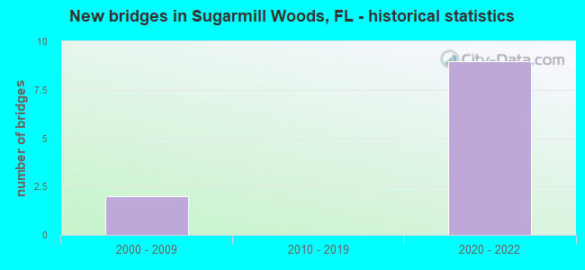
- New bridges - historical statistics
- 22000-2009
- 92020-2022
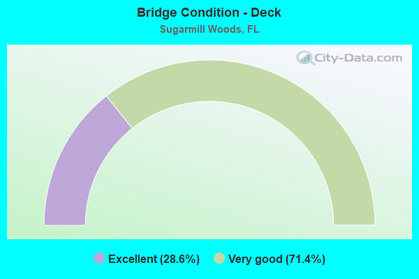
- Bridge Condition - Deck
- 28.6%Excellent
- 71.4%Very good
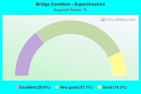
- Bridge Condition - Superstructure
- 28.6%Excellent
- 57.1%Very good
- 14.3%Good
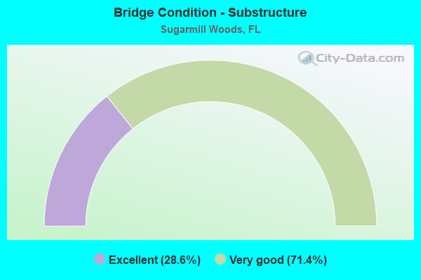
- Bridge Condition - Substructure
- 28.6%Excellent
- 71.4%Very good
Find on map >> Show street view
Structure Number: 20051, Location: 1.2 MI N/O US 98 (Lat: 28.705000, Lng: -82.499833), Route carried "on" structure: State highway 589, Year Built: 2021, Status: Not yet open, Structure Length: 3.19m (10.47ft), Average Daily Traffic: 10,400 (year 2021), Truck Traffic: 9%, Average Future Daily Traffic: 15,500 (year 2041), Design Load: HL 93, Features Intersected: WILDLIFE CROSSING
Minimum Vertical Clearance: 30.45m (99.90ft), Kilometerpoint: 31.157, Lanes on structure: 2, Base Highway Network: Yes, Toll: On toll road, Owner: State Toll Authority, Approaching Roadway Width: 11.6m (38.1ft), Material/Design: Prestressed concrete, Design/Construction: Stringer/Multi-beam, Number Of Spans In Main Unit: 1, Length of Maximum Span: 31.9m (104.7ft), Curb-To-Curb Width: 12.2m (40.0ft), Out-to-Out Width: 13.1m (43.0ft)
Condition: Deck: Excellent, Superstructure: Excellent, Substructure: Excellent, Operating Rating: 46.8 metric tons, Method Used To Determine Operating Rating: Load and Resistance Factor (LRFR), Inventory Rating: 34.5 metric tons, Method Used To Determine Inventory Rating: Load and Resistance Factor (LRFR), Structural Evaluation: Superior to present desirable criteria, Deck Geometry: Better than present minimum criteria, Approach Roadway Alignment: Equal to present desirable criteria, Designated Inspection Frequency: Every 24 months, Inspection Date: September 2021, Deck Structure Type: Concrete Cast-file-Place
Find on map >> Show street view
Structure Number: 20052, Location: 1.2 MI N/O US 98 (Lat: 28.705000, Lng: -82.499528), Route carried "on" structure: State highway 589, Year Built: 2021, Status: Not yet open, Structure Length: 3.19m (10.47ft), Average Daily Traffic: 10,400 (year 2021), Truck Traffic: 9%, Average Future Daily Traffic: 15,500 (year 2041), Design Load: HL 93, Features Intersected: WILDLIFE CROSSING
Minimum Vertical Clearance: 30.18m (99.02ft), Kilometerpoint: 31.157, Lanes on structure: 2, Base Highway Network: Yes, Toll: On toll road, Owner: State Toll Authority, Approaching Roadway Width: 11.6m (38.1ft), Material/Design: Prestressed concrete, Design/Construction: Stringer/Multi-beam, Number Of Spans In Main Unit: 1, Length of Maximum Span: 31.9m (104.7ft), Curb-To-Curb Width: 12.2m (40.0ft), Out-to-Out Width: 13.1m (43.0ft)
Condition: Deck: Excellent, Superstructure: Excellent, Substructure: Excellent, Operating Rating: 46.8 metric tons, Method Used To Determine Operating Rating: Load and Resistance Factor (LRFR), Inventory Rating: 34.5 metric tons, Method Used To Determine Inventory Rating: Load and Resistance Factor (LRFR), Structural Evaluation: Superior to present desirable criteria, Deck Geometry: Better than present minimum criteria, Approach Roadway Alignment: Equal to present desirable criteria, Designated Inspection Frequency: Every 24 months, Inspection Date: September 2021, Deck Structure Type: Concrete Cast-file-Place
Find on map >> Show street view
Structure Number: 20053, Location: 2.2 MI N/O US 98 (Lat: 28.720500, Lng: -82.499972), Route carried "on" structure: State highway 589, Year Built: 2021, Status: Not yet open, Structure Length: 3.68m (12.07ft), Average Daily Traffic: 10,400 (year 2021), Truck Traffic: 9%, Average Future Daily Traffic: 15,500 (year 2041), Design Load: HL 93, Features Intersected: CR 480
Minimum Vertical Clearance: 30.18m (99.02ft), Kilometerpoint: 33.732, Lanes on structure: 2, Lanes under structure: 4, Base Highway Network: Yes, Toll: On toll road, Owner: State Toll Authority, Approaching Roadway Width: 11.6m (38.1ft), Skew: 1 degrees, Material/Design: Prestressed concrete, Design/Construction: Stringer/Multi-beam, Number Of Spans In Main Unit: 1, Length of Maximum Span: 36.8m (120.7ft), Curb-To-Curb Width: 12.2m (40.0ft), Out-to-Out Width: 13.1m (43.0ft)
Condition: Deck: Very good, Superstructure: Very good, Substructure: Very good, Operating Rating: 50.3 metric tons, Method Used To Determine Operating Rating: Load and Resistance Factor (LRFR), Inventory Rating: 36.7 metric tons, Method Used To Determine Inventory Rating: Load and Resistance Factor (LRFR), Structural Evaluation: Equal to present desirable criteria, Deck Geometry: Better than present minimum criteria, Underclear: Equal to present desirable criteria, Approach Roadway Alignment: Equal to present desirable criteria, Designated Inspection Frequency: Every 24 months, Inspection Date: September 2021, Deck Structure Type: Concrete Cast-file-Place
Find on map >> Show street view
Structure Number: 20054, Location: 2.2 MI N/O US 98 (Lat: 28.720417, Lng: -82.499639), Route carried "on" structure: State highway 589, Year Built: 2021, Status: Not yet open, Structure Length: 3.68m (12.07ft), Average Daily Traffic: 10,400 (year 2021), Truck Traffic: 9%, Average Future Daily Traffic: 1,500 (year 2041), Design Load: HL 93, Features Intersected: CR 480
Minimum Vertical Clearance: 30.18m (99.02ft), Kilometerpoint: 33.732, Lanes on structure: 2, Lanes under structure: 4, Base Highway Network: Yes, Toll: On toll road, Owner: State Toll Authority, Approaching Roadway Width: 11.6m (38.1ft), Skew: 1 degrees, Material/Design: Prestressed concrete, Design/Construction: Stringer/Multi-beam, Number Of Spans In Main Unit: 1, Length of Maximum Span: 36.8m (120.7ft), Curb-To-Curb Width: 12.2m (40.0ft), Out-to-Out Width: 13.1m (43.0ft)
Condition: Deck: Very good, Superstructure: Very good, Substructure: Very good, Operating Rating: 50.3 metric tons, Method Used To Determine Operating Rating: Load and Resistance Factor (LRFR), Inventory Rating: 36.0 metric tons, Method Used To Determine Inventory Rating: Load and Resistance Factor (LRFR), Structural Evaluation: Equal to present desirable criteria, Deck Geometry: Better than present minimum criteria, Underclear: Equal to present desirable criteria, Approach Roadway Alignment: Equal to present desirable criteria, Designated Inspection Frequency: Every 24 months, Inspection Date: September 2021, Deck Structure Type: Concrete Cast-file-Place
Find on map >> Show street view
Structure Number: 80056, Location: 10.2MI NORTH OF SR 50 (Lat: 28.670122, Lng: -82.494606), Route carried "on" structure: State highway 589, Year Built: 2000, Status: Open, Structure Length: 1.89m (6.20ft), Average Daily Traffic: 2,950 (year 2020), Truck Traffic: 10%, Average Future Daily Traffic: 5,118 (year 2042), Design Load: HS 20+Mod, Features Intersected: LANDFILL RD
Minimum Vertical Clearance: 30+ m (98+ ft), Kilometerpoint: 27.270, Lanes on structure: 2, Base Highway Network: Yes, Toll: On toll road, Owner: State Toll Authority, Approaching Roadway Width: 14.8m (48.6ft), Material/Design: Prestressed concrete, Design/Construction: Stringer/Multi-beam, Number Of Spans In Main Unit: 1, Length of Maximum Span: 18.9m (62.0ft), Curb-To-Curb Width: 15.8m (51.8ft), Out-to-Out Width: 16.5m (54.1ft)
Condition: Deck: Very good, Superstructure: Very good, Substructure: Very good, Operating Rating: 47.6 metric tons, Method Used To Determine Operating Rating: Load and Resistance Factor (LRFR), Inventory Rating: 36.7 metric tons, Method Used To Determine Inventory Rating: Load and Resistance Factor (LRFR), Structural Evaluation: Equal to present desirable criteria, Deck Geometry: Superior to present desirable criteria, Approach Roadway Alignment: Equal to present desirable criteria, Designated Inspection Frequency: Every 24 months, Inspection Date: May 2020, Deck Structure Type: Concrete Cast-file-Place
Find on map >> Show street view
Structure Number: 80057, Location: 10.2 MI NORTH OF SR 50 (Lat: 28.670050, Lng: -82.494903), Route carried "on" structure: State highway 589, Year Built: 2000, Status: Open, Structure Length: 1.89m (6.20ft), Average Daily Traffic: 2,950 (year 2020), Truck Traffic: 10%, Average Future Daily Traffic: 5,118 (year 2042), Design Load: HS 20+Mod, Features Intersected: LANDFILL RD
Minimum Vertical Clearance: 30+ m (98+ ft), Kilometerpoint: 27.272, Lanes on structure: 2, Base Highway Network: Yes, Toll: On toll road, Owner: State Toll Authority, Approaching Roadway Width: 14.8m (48.6ft), Material/Design: Prestressed concrete, Design/Construction: Stringer/Multi-beam, Number Of Spans In Main Unit: 1, Length of Maximum Span: 18.9m (62.0ft), Curb-To-Curb Width: 15.8m (51.8ft), Out-to-Out Width: 16.5m (54.1ft)
Condition: Deck: Very good, Superstructure: Good, Substructure: Very good, Operating Rating: 47.6 metric tons, Method Used To Determine Operating Rating: Load and Resistance Factor (LRFR), Inventory Rating: 36.7 metric tons, Method Used To Determine Inventory Rating: Load and Resistance Factor (LRFR), Structural Evaluation: Better than present minimum criteria, Deck Geometry: Superior to present desirable criteria, Approach Roadway Alignment: Equal to present desirable criteria, Designated Inspection Frequency: Every 24 months, Inspection Date: May 2020, Deck Structure Type: Concrete Cast-file-Place
Find on map >> Show street view
Structure Number: 80061, Location: 5.25 MI S/O CARDINAL ST (Lat: 28.687278, Lng: -82.497917), Route carried "on" structure: State highway 589, Year Built: 2021, Status: Not yet open, Structure Length: 8.35m (27.40ft), Average Daily Traffic: 10,400 (year 2021), Truck Traffic: 9%, Average Future Daily Traffic: 15,500 (year 2041), Design Load: HL 93, Features Intersected: US 98
Minimum Vertical Clearance: 30.45m (99.90ft), Kilometerpoint: 25.218, Lanes on structure: 2, Lanes under structure: 6, Base Highway Network: Yes, Toll: On toll road, Owner: State Toll Authority, Approaching Roadway Width: 11.6m (38.1ft), Skew: 4 degrees, Material/Design: Prestressed concrete, Design/Construction: Stringer/Multi-beam, Number Of Spans In Main Unit: 2, Length of Maximum Span: 41.7m (136.8ft), Curb-To-Curb Width: 12.2m (40.0ft), Out-to-Out Width: 13.1m (43.0ft)
Condition: Deck: Very good, Superstructure: Very good, Substructure: Very good, Operating Rating: 51.8 metric tons, Method Used To Determine Operating Rating: Load and Resistance Factor (LRFR), Inventory Rating: 35.2 metric tons, Method Used To Determine Inventory Rating: Load and Resistance Factor (LRFR), Structural Evaluation: Equal to present desirable criteria, Deck Geometry: Better than present minimum criteria, Underclear: Superior to present desirable criteria, Approach Roadway Alignment: Equal to present desirable criteria, Designated Inspection Frequency: Every 24 months, Inspection Date: September 2021, Deck Structure Type: Concrete Cast-file-Place
Find on map >> Show street view
Structure Number: 20053, Location: 2.2 MI N/O US 98 (Lat: 28.720500, Lng: -82.499972), Route carried "under" structure: County highway 480, Year Built: 2021, Structure Length: 0. m, Average Daily Traffic: 2,300 (year 2021), Truck Traffic: 6%, Features Intersected: CR 480, Facility Carried by Structure: SR 589 SB SCP 57.8
Minimum Vertical Clearance: 6.43m (21.10ft), Kilometerpoint: 0.000, Lanes on structure: 2, Lanes under structure: 4, Material/Design: Prestressed concrete, Design/Construction: Stringer/Multi-beam, Length of Maximum Span: 36.8m (120.7ft)
Find on map >> Show street view
Structure Number: 20054, Location: 2.2 MI N/O US 98 (Lat: 28.720417, Lng: -82.499639), Route carried "under" structure: County highway 480, Year Built: 2021, Structure Length: 0. m, Average Daily Traffic: 2,300 (year 2021), Truck Traffic: 6%, Features Intersected: CR 480, Facility Carried by Structure: SR 589 NB SCP 57.8
Minimum Vertical Clearance: 5.36m (17.59ft), Kilometerpoint: 0.000, Lanes on structure: 2, Lanes under structure: 4, Material/Design: Prestressed concrete, Design/Construction: Stringer/Multi-beam, Length of Maximum Span: 36.8m (120.7ft)
Find on map >> Show street view
Structure Number: 8006, Location: 5.25 MI S/O CARDINAL ST (Lat: 28.687472, Lng: -82.498278), Route carried "under" structure: US 98, Year Built: 2021, Structure Length: 0. m, Average Daily Traffic: 8,800 (year 2021), Truck Traffic: 9%, Features Intersected: US 98, Facility Carried by Structure: SB SR 589 SCP 52.5
Minimum Vertical Clearance: 5.15m (16.90ft), Kilometerpoint: 19.550, Lanes on structure: 2, Lanes under structure: 6, Material/Design: Prestressed concrete, Design/Construction: Stringer/Multi-beam, Length of Maximum Span: 41.7m (136.8ft)
Find on map >> Show street view
Structure Number: 80061, Location: 5.25 MI S/O CARDINAL ST (Lat: 28.687278, Lng: -82.497917), Route carried "under" structure: US 98, Year Built: 2021, Structure Length: 0. m, Average Daily Traffic: 8,800 (year 2021), Truck Traffic: 9%, Features Intersected: US 98, Facility Carried by Structure: NB SR 589 SCP 52.5
Minimum Vertical Clearance: 5.15m (16.90ft), Kilometerpoint: 19.470, Lanes on structure: 2, Lanes under structure: 6, Material/Design: Prestressed concrete, Design/Construction: Stringer/Multi-beam, Length of Maximum Span: 41.7m (136.8ft)