Bridge Statistics for Summersville, West Virginia (WV)
Condition, Traffic, Stress, Structural Evaluation, Project Costs
- National Bridge Inventory (NBI) Statistics
- 16Number of bridges
- 509ft / 155mTotal length
- $4,560,000Total costs
- 87,383Total average daily traffic
- 13,554Total average daily truck traffic
- National Bridge Inventory (NBI) Registered Bridges for Summersville
- No street view available for this location
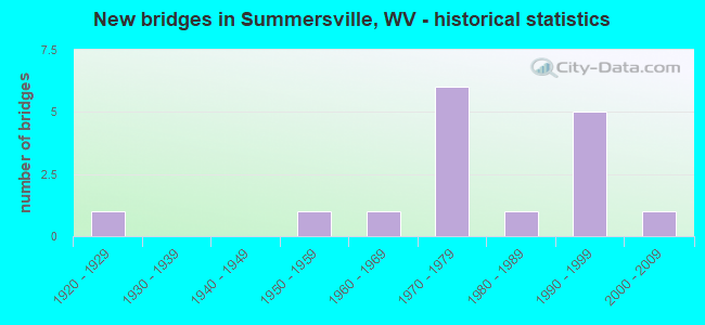
- New bridges - historical statistics
- 11920-1929
- 11950-1959
- 11960-1969
- 61970-1979
- 11980-1989
- 51990-1999
- 12000-2009


- Bridge Condition - Deck
- 27.3%Good
- 45.5%Satisfactory
- 27.3%Poor

- Bridge Condition - Superstructure
- 45.5%Good
- 18.2%Satisfactory
- 9.1%Fair
- 27.3%Poor

- Bridge Condition - Substructure
- 9.1%Good
- 27.3%Satisfactory
- 45.5%Fair
- 18.2%Poor

- Bridge Condition - Channel
- 25.0%Excellent
- 25.0%Very good
- 16.7%Good
- 8.3%Satisfactory
- 16.7%Fair
- 8.3%Serious

- Bridge Condition - Culverts
- 33.3%Good
- 66.7%Satisfactory
Find on map >> Show street view
Structure Number: 34A013, Location: 0.13 Miles S. of WV 55 (Lat: 38.363019, Lng: -80.805411), Route carried "on" structure: County highway 600, Year Built: 1950, Status: Posted for load, Structure Length: 1.03m (3.38ft), Average Daily Traffic: 30 (year 2020), Truck Traffic: 4%, Average Future Daily Traffic: 37 (year 2040), Features Intersected: MCMILLION CREEK, Facility Carried by Structure: COUNTY ROUTE 6
Minimum Vertical Clearance: 30+ m (98+ ft), Kilometerpoint: 1.786, Lanes on structure: 1, Owner: State Highway Agency, Approaching Roadway Width: 4.3m (14.1ft), Material/Design: Steel, Design/Construction: Girder and Floorbeam System, Number Of Spans In Main Unit: 1, Length of Maximum Span: 8.9m (29.2ft), Curb-To-Curb Width: 4.8m (15.7ft), Out-to-Out Width: 4.9m (16.1ft)
Condition: Deck: Poor, Superstructure: Poor, Substructure: Poor, Channel: Serious, Operating Rating: 32.7 metric tons, Method Used To Determine Operating Rating: Load Factor (LF), Inventory Rating: 20.0 metric tons, Method Used To Determine Inventory Rating: Load Factor (LF), Structural Evaluation: Meets minimum limits, Deck Geometry: Equal to present desirable criteria, Waterway Adequacy: Equal to present minimum criteria, Approach Roadway Alignment: Equal to present desirable criteria, Length Of Structure Improvement: 1.71m (5.61ft), Designated Inspection Frequency: Every 24 months, Other Special Inspection Frequency: Every 12 months, Inspection Date: January 2020, Other Special Inspection Date: January 2021, Bridge Improvement Cost: $357,000, Roadway Improvement Cost: $221,000, Total Project Cost: $578,000 ( Estimate for 2021), Deck Structure Type: Wood or Timber, Wearing Surface/Protective System: Deck Protection: Other
Find on map >> Show street view
Structure Number: 34A014, Location: 0.01 Miles E. of US 19 (Lat: 38.326800, Lng: -80.832519), Route carried "on" structure: County highway 800, Year Built: 1978, Status: Open, Structure Length: 3.05m (10.01ft), Average Daily Traffic: 800 (year 2019), Truck Traffic: 6%, Average Future Daily Traffic: 1,008 (year 2039), Design Load: HS 20, Features Intersected: MUDDLETY CREEK, Facility Carried by Structure: COUNTY ROUTE 8
Minimum Vertical Clearance: 30+ m (98+ ft), Kilometerpoint: 0.016, Lanes on structure: 2, Owner: State Highway Agency, Approaching Roadway Width: 10.7m (35.1ft), Material/Design: Steel, Design/Construction: Stringer/Multi-beam, Number Of Spans In Main Unit: 1, Length of Maximum Span: 29.1m (95.5ft), Curb-To-Curb Width: 11.7m (38.4ft), Out-to-Out Width: 13.0m (42.7ft)
Condition: Deck: Good, Superstructure: Good, Substructure: Fair, Channel: Very good, Operating Rating: 71.7 metric tons, Method Used To Determine Operating Rating: Load Factor (LF), Inventory Rating: 42.6 metric tons, Method Used To Determine Inventory Rating: Load Factor (LF), Structural Evaluation: Somewhat better than minimum adequacy, Deck Geometry: Better than present minimum criteria, Waterway Adequacy: Superior to present desirable criteria, Approach Roadway Alignment: High priority of corrective action, Length Of Structure Improvement: 3.05m (10.01ft), Designated Inspection Frequency: Every 24 months, Inspection Date: Febuary 2020, Bridge Improvement Cost: $125,000, Roadway Improvement Cost: $10,000, Total Project Cost: $135,000 ( Estimate for 2020), Deck Structure Type: Concrete Cast-file-Place, Wearing Surface/Protective System: Wearing Surface: Monolithic Concrete, Deck Protection: Epoxy Coated Reinforcing
Find on map >> Show street view
Structure Number: 34A016, Location: 0.43 Miles S. of WV 41 (Lat: 38.306839, Lng: -80.822469), Route carried "on" structure: County highway 1200, Year Built: 1978, Status: Posted for load, Structure Length: 0.96m (3.15ft), Average Daily Traffic: 861 (year 2019), Truck Traffic: 4%, Average Future Daily Traffic: 1,050 (year 2039), Design Load: HS 20, Features Intersected: GLADE CREEK, Facility Carried by Structure: COUNTY ROUTE 12
Minimum Vertical Clearance: 30+ m (98+ ft), Kilometerpoint: 0.692, Lanes on structure: 2, Owner: State Highway Agency, Approaching Roadway Width: 6.7m (22.0ft), Skew: 2 degrees, Material/Design: Prestressed concrete, Design/Construction: Channel Beam, Number Of Spans In Main Unit: 1, Length of Maximum Span: 9.0m (29.5ft), Curb-To-Curb Width: 6.8m (22.3ft), Out-to-Out Width: 7.3m (24.0ft)
Condition: Deck: Poor, Superstructure: Poor, Substructure: Fair, Channel: Very good, Operating Rating: 39.0 metric tons, Method Used To Determine Operating Rating: Load Factor (LF), Inventory Rating: 23.6 metric tons, Method Used To Determine Inventory Rating: Load Factor (LF), Structural Evaluation: Meets minimum limits, Deck Geometry: Meets minimum limits, Waterway Adequacy: Superior to present desirable criteria, Approach Roadway Alignment: Equal to present desirable criteria, Length Of Structure Improvement: 1.59m (5.22ft), Designated Inspection Frequency: Every 24 months, Inspection Date: January 2020, Bridge Improvement Cost: $222,000, Roadway Improvement Cost: $22,000, Total Project Cost: $576,000 ( Estimate for 2020), Deck Structure Type: Other, Wearing Surface/Protective System: Wearing Surface: Bituminous
Find on map >> Show street view
Structure Number: 34A026, Location: 0.22 Miles N. of CR 19/66 (Lat: 38.240150, Lng: -80.854361), Route carried "on" structure: US 1900, Year Built: 1963, Year Reconstructed: 1991, Status: Posted for load, Structure Length: 42.70m (140.09ft), Average Daily Traffic: 15,600 (year 2019), Truck Traffic: 17%, Average Future Daily Traffic: 22,464 (year 2039), Design Load: HS 20, Features Intersected: SUMMERSVILLE LAKE, Facility Carried by Structure: US 19 SBL
Minimum Vertical Clearance: 30+ m (98+ ft), Kilometerpoint: 13.100, Lanes on structure: 2, Base Highway Network: Yes, Owner: State Highway Agency, Approaching Roadway Width: 12.2m (40.0ft), Material/Design: Steel continuous, Design/Construction: Truss - Deck, Number Of Spans In Main Unit: 3, Number Of Approach Spans: 4, Length of Maximum Span: 121.9m (399.9ft), Curb or Sidewalk Widths: Left: 2.0m (6.6ft), Right: 0.0m, Curb-To-Curb Width: 8.7m (28.5ft), Out-to-Out Width: 11.3m (37.1ft)
Condition: Deck: Satisfactory, Superstructure: Fair, Substructure: Fair, Channel: Excellent, Operating Rating: 60.8 metric tons, Method Used To Determine Operating Rating: Load Factor (LF), Inventory Rating: 37.2 metric tons, Method Used To Determine Inventory Rating: Load Factor (LF), Structural Evaluation: Somewhat better than minimum adequacy, Deck Geometry: High priority of corrective action, Waterway Adequacy: Superior to present desirable criteria, Approach Roadway Alignment: Equal to present desirable criteria, Length Of Structure Improvement: 42.61m (139.80ft), Designated Inspection Frequency: Every 24 months, Critical Feature Inspection Frequency: Every 24 months, Underwater Inspection Frequency: Every 60 months, Inspection Date: June 2021, Critical Feature Inspection Date: June 2021, Underwater Inspection Date: December 2018, Bridge Improvement Cost: $1,807,000, Roadway Improvement Cost: $217,000, Total Project Cost: $2,227,000 ( Estimate for 2021), Deck Structure Type: Concrete Cast-file-Place, Wearing Surface/Protective System: Wearing Surface: Monolithic Concrete, Deck Protection: Epoxy Coated Reinforcing
Find on map >> Show street view
Structure Number: 34A029, Location: 0.18 Miles N. of CR 19/30 (Lat: 38.300050, Lng: -80.915881), Route carried "on" structure: County highway 1915, Year Built: 1980, Status: Open, Structure Length: 0.83m (2.72ft), Average Daily Traffic: 324 (year 2019), Truck Traffic: 4%, Average Future Daily Traffic: 395 (year 2039), Design Load: HS 20, Features Intersected: PETERS CREEK, Facility Carried by Structure: COUNTY ROUTE 19/15
Minimum Vertical Clearance: 30+ m (98+ ft), Kilometerpoint: 0.370, Lanes on structure: 2, Owner: State Highway Agency, Approaching Roadway Width: 7.3m (24.0ft), Material/Design: Prestressed concrete, Design/Construction: Box Beam or Girders - Multiple, Number Of Spans In Main Unit: 1, Length of Maximum Span: 8.0m (26.2ft), Curb-To-Curb Width: 8.4m (27.6ft), Out-to-Out Width: 9.2m (30.2ft)
Condition: Deck: Satisfactory, Superstructure: Satisfactory, Substructure: Fair, Channel: Good, Operating Rating: 59.9 metric tons, Method Used To Determine Operating Rating: Load Factor (LF), Inventory Rating: 36.3 metric tons, Method Used To Determine Inventory Rating: Load Factor (LF), Structural Evaluation: Somewhat better than minimum adequacy, Deck Geometry: Somewhat better than minimum adequacy, Waterway Adequacy: Superior to present desirable criteria, Approach Roadway Alignment: Equal to present desirable criteria, Designated Inspection Frequency: Every 24 months, Inspection Date: January 2020, Deck Structure Type: Other, Wearing Surface/Protective System: Wearing Surface: Bituminous
Find on map >> Show street view
Structure Number: 34A076, Location: 0.17 Miles E. of CR 19/41 (Lat: 38.368311, Lng: -80.820069), Route carried "on" structure: State highway 5500, Year Built: 1929, Status: Posted for load, Structure Length: 1.62m (5.31ft), Average Daily Traffic: 1,200 (year 2019), Truck Traffic: 11%, Average Future Daily Traffic: 1,512 (year 2039), Features Intersected: MUDDLETY CREEK, Facility Carried by Structure: WV 55
Minimum Vertical Clearance: 30+ m (98+ ft), Kilometerpoint: 0.885, Lanes on structure: 2, Owner: State Highway Agency, Approaching Roadway Width: 7.6m (24.9ft), Material/Design: Concrete, Design/Construction: Tee Beam, Number Of Spans In Main Unit: 1, Length of Maximum Span: 15.7m (51.5ft), Curb-To-Curb Width: 6.6m (21.7ft), Out-to-Out Width: 7.7m (25.3ft)
Condition: Deck: Poor, Superstructure: Poor, Substructure: Poor, Channel: Good, Operating Rating: 41.7 metric tons, Method Used To Determine Operating Rating: Field evaluation and documented engineering judgment, Inventory Rating: 17.2 metric tons, Method Used To Determine Inventory Rating: Field evaluation and documented engineering judgment, Structural Evaluation: Meets minimum limits, Deck Geometry: High priority of replacement, Waterway Adequacy: Equal to present desirable criteria, Approach Roadway Alignment: Equal to present desirable criteria, Length Of Structure Improvement: 2.26m (7.41ft), Designated Inspection Frequency: Every 24 months, Inspection Date: Febuary 2020, Bridge Improvement Cost: $498,000, Roadway Improvement Cost: $288,000, Total Project Cost: $786,000 ( Estimate for 2018), Deck Structure Type: Concrete Cast-file-Place, Wearing Surface/Protective System: Wearing Surface: Bituminous
Find on map >> Show street view
Structure Number: 34A082, Location: 0.01 Miles E. of US 19 (Lat: 38.310761, Lng: -80.833461), Route carried "on" structure: State highway 4100, Year Built: 1978, Status: Open, Structure Length: 2.56m (8.40ft), Average Daily Traffic: 6,600 (year 2019), Truck Traffic: 11%, Average Future Daily Traffic: 8,317 (year 2039), Design Load: HS 20, Features Intersected: MUDDLETY CREEK, Facility Carried by Structure: WV 41
Minimum Vertical Clearance: 30+ m (98+ ft), Kilometerpoint: 28.308, Lanes on structure: 3, Owner: State Highway Agency, Approaching Roadway Width: 7.9m (25.9ft), Material/Design: Steel, Design/Construction: Stringer/Multi-beam, Number Of Spans In Main Unit: 1, Length of Maximum Span: 24.2m (79.4ft), Curb-To-Curb Width: 14.2m (46.6ft), Out-to-Out Width: 15.4m (50.5ft)
Condition: Deck: Satisfactory, Superstructure: Satisfactory, Substructure: Fair, Channel: Very good, Operating Rating: 88.9 metric tons, Method Used To Determine Operating Rating: Load Factor (LF), Inventory Rating: 63.5 metric tons, Method Used To Determine Inventory Rating: Load Factor (LF), Structural Evaluation: Somewhat better than minimum adequacy, Deck Geometry: Somewhat better than minimum adequacy, Waterway Adequacy: Superior to present desirable criteria, Approach Roadway Alignment: Better than present minimum criteria, Designated Inspection Frequency: Every 24 months, Inspection Date: Febuary 2020, Deck Structure Type: Concrete Cast-file-Place, Wearing Surface/Protective System: Wearing Surface: Monolithic Concrete
Find on map >> Show street view
Structure Number: 34A092, Location: 1.01 Miles S. of CR 41/2 (Lat: 38.240381, Lng: -80.854211), Route carried "on" structure: US 1900, Year Built: 1994, Status: Open, Structure Length: 45.27m (148.52ft), Average Daily Traffic: 15,116 (year 2019), Truck Traffic: 17%, Average Future Daily Traffic: 21,767 (year 2039), Design Load: HS 25 or greater, Features Intersected: SUMMERSVILLE LAKE, Facility Carried by Structure: US 19 NBL
Minimum Vertical Clearance: 30+ m (98+ ft), Kilometerpoint: 13.100, Lanes on structure: 2, Base Highway Network: Yes, Owner: State Highway Agency, Approaching Roadway Width: 12.2m (40.0ft), Material/Design: Steel continuous, Design/Construction: Truss - Deck, Number Of Spans In Main Unit: 3, Number Of Approach Spans: 5, Length of Maximum Span: 121.9m (399.9ft), Curb-To-Curb Width: 9.8m (32.2ft), Out-to-Out Width: 10.8m (35.4ft)
Condition: Deck: Good, Superstructure: Good, Substructure: Satisfactory, Channel: Excellent, Operating Rating: 68.9 metric tons, Method Used To Determine Operating Rating: Load Factor (LF), Inventory Rating: 41.7 metric tons, Method Used To Determine Inventory Rating: Load Factor (LF), Structural Evaluation: Equal to present minimum criteria, Deck Geometry: Meets minimum limits, Waterway Adequacy: Superior to present desirable criteria, Approach Roadway Alignment: Equal to present desirable criteria, Length Of Structure Improvement: 6.25m (20.51ft), Designated Inspection Frequency: Every 24 months, Critical Feature Inspection Frequency: Every 24 months, Underwater Inspection Frequency: Every 60 months, Inspection Date: June 2020, Critical Feature Inspection Date: June 2020, Underwater Inspection Date: December 2018, Bridge Improvement Cost: $63,000, Total Project Cost: $70,000 ( Estimate for 2020), Deck Structure Type: Concrete Cast-file-Place, Wearing Surface/Protective System: Wearing Surface: Monolithic Concrete, Deck Protection: Epoxy Coated Reinforcing
Find on map >> Show street view
Structure Number: 34A106, Location: 0.87 Miles N. of CR 43/1 (Lat: 38.367900, Lng: -80.828561), Route carried "on" structure: US 1900, Year Built: 1997, Status: Open, Structure Length: 4.20m (13.78ft), Average Daily Traffic: 11,398 (year 2019), Truck Traffic: 17%, Average Future Daily Traffic: 16,413 (year 2039), Design Load: HS 25 or greater, Features Intersected: WV 55, Facility Carried by Structure: US 19 NBL
Minimum Vertical Clearance: 30+ m (98+ ft), Kilometerpoint: 28.856, Lanes on structure: 2, Lanes under structure: 2, Base Highway Network: Yes, Owner: State Highway Agency, Approaching Roadway Width: 12.5m (41.0ft), Material/Design: Steel, Design/Construction: Stringer/Multi-beam, Number Of Spans In Main Unit: 1, Length of Maximum Span: 41.0m (134.5ft), Curb-To-Curb Width: 12.6m (41.3ft), Out-to-Out Width: 13.6m (44.6ft)
Condition: Deck: Satisfactory, Superstructure: Good, Substructure: Satisfactory, Operating Rating: 88.9 metric tons, Method Used To Determine Operating Rating: Load Factor (LF), Inventory Rating: 61.7 metric tons, Method Used To Determine Inventory Rating: Load Factor (LF), Structural Evaluation: Equal to present minimum criteria, Deck Geometry: Better than present minimum criteria, Underclear: Meets minimum limits, Approach Roadway Alignment: Equal to present desirable criteria, Designated Inspection Frequency: Every 24 months, Inspection Date: April 2020, Deck Structure Type: Concrete Cast-file-Place, Wearing Surface/Protective System: Wearing Surface: Monolithic Concrete, Deck Protection: Epoxy Coated Reinforcing
Find on map >> Show street view
Structure Number: 34A107, Location: 0.87 Miles S. of CR 43/1 (Lat: 38.368031, Lng: -80.828750), Route carried "on" structure: US 1900, Year Built: 1997, Status: Open, Structure Length: 4.20m (13.78ft), Average Daily Traffic: 5,450 (year 2019), Truck Traffic: 17%, Average Future Daily Traffic: 8,069 (year 2039), Design Load: HS 25 or greater, Features Intersected: WV 55, Facility Carried by Structure: US 19 SBL
Minimum Vertical Clearance: 30+ m (98+ ft), Kilometerpoint: 28.856, Lanes on structure: 2, Lanes under structure: 2, Base Highway Network: Yes, Owner: State Highway Agency, Approaching Roadway Width: 12.2m (40.0ft), Material/Design: Steel, Design/Construction: Stringer/Multi-beam, Number Of Spans In Main Unit: 1, Length of Maximum Span: 41.0m (134.5ft), Curb-To-Curb Width: 12.6m (41.3ft), Out-to-Out Width: 13.6m (44.6ft)
Condition: Deck: Satisfactory, Superstructure: Good, Substructure: Satisfactory, Operating Rating: 88.9 metric tons, Method Used To Determine Operating Rating: Load Factor (LF), Inventory Rating: 61.7 metric tons, Method Used To Determine Inventory Rating: Load Factor (LF), Structural Evaluation: Equal to present minimum criteria, Deck Geometry: Better than present minimum criteria, Underclear: Meets minimum limits, Approach Roadway Alignment: Equal to present desirable criteria, Designated Inspection Frequency: Every 24 months, Inspection Date: April 2020, Deck Structure Type: Concrete Cast-file-Place, Wearing Surface/Protective System: Wearing Surface: Monolithic Concrete, Deck Protection: Epoxy Coated Reinforcing
Find on map >> Show street view
Structure Number: 34A108, Location: 0.04 Miles N. of WV 55 (Lat: 38.369250, Lng: -80.826931), Route carried "on" structure: US 1900, Year Built: 1972, Status: Open, Structure Length: 0.84m (2.76ft), Average Daily Traffic: 10,900 (year 2019), Truck Traffic: 17%, Average Future Daily Traffic: 16,137 (year 2039), Design Load: HS 20, Features Intersected: ENOCH BRANCH, Facility Carried by Structure: US 19
Minimum Vertical Clearance: 30+ m (98+ ft), Kilometerpoint: 28.920, Lanes on structure: 6, Base Highway Network: Yes, Owner: State Highway Agency, Approaching Roadway Width: 38.7m (127.0ft), Skew: 3 degrees, Material/Design: Steel, Design/Construction: Culvert, Number Of Spans In Main Unit: 2, Length of Maximum Span: 3.0m (9.8ft)
Condition: Channel: Fair, Culverts: Satisfactory, Operating Rating: 89.8 metric tons, Method Used To Determine Operating Rating: Field evaluation and documented engineering judgment, Inventory Rating: 89.8 metric tons, Method Used To Determine Inventory Rating: Field evaluation and documented engineering judgment, Structural Evaluation: Equal to present minimum criteria, Waterway Adequacy: Superior to present desirable criteria, Approach Roadway Alignment: Equal to present desirable criteria, Designated Inspection Frequency: Every 24 months, Inspection Date: March 2020
Find on map >> Show street view
Structure Number: 34A115, Location: 0.14 Miles S. of US 19 (Lat: 38.357881, Lng: -80.837719), Route carried "on" structure: County highway 4301, Year Built: 1972, Status: Open, Structure Length: 1.48m (4.86ft), Average Daily Traffic: 665 (year 2019), Truck Traffic: 4%, Average Future Daily Traffic: 811 (year 2039), Features Intersected: PEARSON BRANCH, Facility Carried by Structure: COUNTY ROUTE 43/1
Minimum Vertical Clearance: 30+ m (98+ ft), Kilometerpoint: 2.816, Lanes on structure: 2, Owner: State Highway Agency, Approaching Roadway Width: 9.8m (32.2ft), Skew: 3 degrees, Material/Design: Steel, Design/Construction: Culvert, Number Of Spans In Main Unit: 2, Length of Maximum Span: 5.9m (19.4ft)
Condition: Channel: Fair, Culverts: Good, Operating Rating: 71.7 metric tons, Method Used To Determine Operating Rating: Field evaluation and documented engineering judgment, Inventory Rating: 32.7 metric tons, Method Used To Determine Inventory Rating: Field evaluation and documented engineering judgment, Structural Evaluation: Better than present minimum criteria, Waterway Adequacy: Better than present minimum criteria, Approach Roadway Alignment: Better than present minimum criteria, Length Of Structure Improvement: 0.61m (2.00ft), Designated Inspection Frequency: Every 24 months, Inspection Date: January 2020, Total Project Cost: $188,000 ( Estimate for 2020)
Find on map >> Show street view
Structure Number: 34A116, Location: 0.55 Miles S. of CR 43/1 (Lat: 38.347861, Lng: -80.836389), Route carried "on" structure: US 1900, Year Built: 1972, Status: Open, Structure Length: 1.15m (3.77ft), Average Daily Traffic: 11,644 (year 2020), Truck Traffic: 17%, Average Future Daily Traffic: 16,767 (year 2040), Features Intersected: TROUT RUN, Facility Carried by Structure: US 19
Minimum Vertical Clearance: 30+ m (98+ ft), Kilometerpoint: 26.570, Lanes on structure: 4, Base Highway Network: Yes, Owner: State Highway Agency, Approaching Roadway Width: 34.4m (112.9ft), Skew: 4 degrees, Material/Design: Steel, Design/Construction: Culvert, Number Of Spans In Main Unit: 2, Length of Maximum Span: 4.3m (14.1ft)
Condition: Channel: Satisfactory, Culverts: Satisfactory, Operating Rating: 71.7 metric tons, Method Used To Determine Operating Rating: Field evaluation and documented engineering judgment, Inventory Rating: 32.7 metric tons, Method Used To Determine Inventory Rating: Field evaluation and documented engineering judgment, Structural Evaluation: Equal to present minimum criteria, Waterway Adequacy: Superior to present desirable criteria, Approach Roadway Alignment: Superior to present desirable criteria, Designated Inspection Frequency: Every 24 months, Inspection Date: January 2021
Find on map >> Show street view
Structure Number: 34A13, Location: 1.36 Miles E. of US 19 (Lat: 38.266169, Lng: -80.816961), Route carried "on" structure: State highway 3900, Year Built: 2006, Status: Open, Structure Length: 45.32m (148.69ft), Average Daily Traffic: 4,395 (year 2019), Truck Traffic: 9%, Average Future Daily Traffic: 5,362 (year 2039), Design Load: HS 25 or greater, Features Intersected: GAULEY RIVER, Facility Carried by Structure: WV 39
Minimum Vertical Clearance: 30+ m (98+ ft), Kilometerpoint: 44.450, Lanes on structure: 2, Owner: State Highway Agency, Approaching Roadway Width: 10.7m (35.1ft), Material/Design: Steel continuous, Design/Construction: Stringer/Multi-beam, Number Of Spans In Main Unit: 6, Length of Maximum Span: 91.4m (299.9ft), Curb-To-Curb Width: 12.2m (40.0ft), Out-to-Out Width: 13.0m (42.7ft)
Condition: Deck: Good, Superstructure: Good, Substructure: Good, Channel: Excellent, Operating Rating: 65.3 metric tons, Method Used To Determine Operating Rating: Field evaluation and documented engineering judgment, Inventory Rating: 32.7 metric tons, Method Used To Determine Inventory Rating: Field evaluation and documented engineering judgment, Structural Evaluation: Better than present minimum criteria, Deck Geometry: Equal to present minimum criteria, Waterway Adequacy: Superior to present desirable criteria, Approach Roadway Alignment: Better than present minimum criteria, Designated Inspection Frequency: Every 24 months, Inspection Date: June 2020, Deck Structure Type: Concrete Cast-file-Place, Wearing Surface/Protective System: Wearing Surface: Monolithic Concrete, Deck Protection: Epoxy Coated Reinforcing
Find on map >> Show street view
Structure Number: 34A106, Location: 0.87 Miles N. of CR 43/1 (Lat: 38.367903, Lng: -80.828564), Route carried "under" structure: State highway 5500, Year Built: 1997, Structure Length: 0. m, Average Daily Traffic: 1,200 (year 0012), Truck Traffic: 11%, Features Intersected: WV 55, Facility Carried by Structure: US 19 NBL
Minimum Vertical Clearance: 6.33m (20.77ft), Kilometerpoint: 0.032, Lanes on structure: 2, Lanes under structure: 2, Length of Maximum Span: 41.0m (134.5ft)
Find on map >> Show street view
Structure Number: 34A107, Location: 0.87 Miles S. of CR 43/1 (Lat: 38.368036, Lng: -80.828758), Route carried "under" structure: State highway 5500, Year Built: 1997, Structure Length: 0. m, Average Daily Traffic: 1,200 (year 0012), Truck Traffic: 11%, Features Intersected: WV 55, Facility Carried by Structure: US 19 SBL
Minimum Vertical Clearance: 6.17m (20.24ft), Kilometerpoint: 0.000, Lanes on structure: 2, Lanes under structure: 2, Length of Maximum Span: 41.0m (134.5ft)