Bridge Statistics for Summit, South Dakota (SD)
Condition, Traffic, Stress, Structural Evaluation, Project Costs
- National Bridge Inventory (NBI) Statistics
- 13Number of bridges
- 144ft / 44.3mTotal length
- $2,661,000Total costs
- 32,812Total average daily traffic
- 7,175Total average daily truck traffic
- National Bridge Inventory (NBI) Registered Bridges for Summit
- No street view available for this location
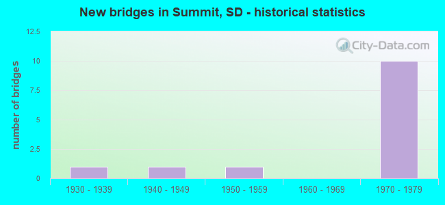
- New bridges - historical statistics
- 11930-1939
- 11940-1949
- 11950-1959
- 101970-1979


- Bridge Condition - Deck
- 77.8%Satisfactory
- 22.2%Fair

- Bridge Condition - Superstructure
- 77.8%Satisfactory
- 22.2%Fair

- Bridge Condition - Substructure
- 22.2%Good
- 55.6%Satisfactory
- 11.1%Fair
- 11.1%Poor

- Bridge Condition - Channel
- 50.0%Good
- 50.0%Poor
Find on map >> Show street view
Structure Number: 2605602, Location: 10.1W & 2.5N MARVIN (Lat: 45.297131, Lng: -97.110633), Route carried "on" structure: County highway , Year Built: 1956, Status: Posted for load, Structure Length: 0.76m (2.49ft), Average Daily Traffic: 55 (year 2020), Truck Traffic: 2%, Average Future Daily Traffic: 61 (year 2040), Features Intersected: CK, Facility Carried by Structure: 144 STREET
Minimum Vertical Clearance: 30+ m (98+ ft), Kilometerpoint: 0.000, Lanes on structure: 2, Owner: County Highway Agency, Approaching Roadway Width: 6.7m (22.0ft), Material/Design: Concrete, Design/Construction: Channel Beam, Number Of Spans In Main Unit: 1, Length of Maximum Span: 7.3m (24.0ft), Curb-To-Curb Width: 7.3m (24.0ft), Out-to-Out Width: 7.8m (25.6ft)
Condition: Deck: Satisfactory, Superstructure: Fair, Substructure: Poor, Channel: Good, Operating Rating: 10.9 metric tons, Method Used To Determine Operating Rating: Field evaluation and documented engineering judgment, Inventory Rating: 8.2 metric tons, Method Used To Determine Inventory Rating: Field evaluation and documented engineering judgment, Structural Evaluation: High priority of replacement, Deck Geometry: Equal to present minimum criteria, Waterway Adequacy: Better than present minimum criteria, Approach Roadway Alignment: Equal to present desirable criteria, Bridge Posting: Required (Relationship of Operating Rating to Maximum Legal Load: > 39.9% below), Length Of Structure Improvement: 0.79m (2.59ft), Designated Inspection Frequency: Every 24 months, Inspection Date: August 2020, Bridge Improvement Cost: $400,000, Roadway Improvement Cost: $100,000, Total Project Cost: $500,000 ( Estimate for 2020), Deck Structure Type: Concrete Precast Panels, Wearing Surface/Protective System: Wearing Surface: Gravel
Find on map >> Show street view
Structure Number: 2608404, Location: 2 S ROBERTS CO LINE (Lat: 45.267858, Lng: -97.051986), Route carried "on" structure: Interstate 29, Year Built: 1977, Status: Open, Structure Length: 3.63m (11.91ft), Average Daily Traffic: 3,260 (year 2021), Truck Traffic: 30%, Average Future Daily Traffic: 4,597 (year 2041), Design Load: HS 20+Mod, Features Intersected: 146 ST
Minimum Vertical Clearance: 30+ m (98+ ft), Kilometerpoint: 328.403, Lanes on structure: 2, Lanes under structure: 2, Base Highway Network: Yes, Owner: State Highway Agency, Approaching Roadway Width: 11.6m (38.1ft), Material/Design: Concrete continuous, Design/Construction: Slab, Number Of Spans In Main Unit: 3, Length of Maximum Span: 13.0m (42.7ft), Curb-To-Curb Width: 12.2m (40.0ft), Out-to-Out Width: 13.0m (42.7ft)
Condition: Deck: Satisfactory, Superstructure: Satisfactory, Substructure: Satisfactory, Operating Rating: 73.6 metric tons, Method Used To Determine Operating Rating: Load Factor (LF), Inventory Rating: 44.1 metric tons, Method Used To Determine Inventory Rating: Load Factor (LF), Structural Evaluation: Equal to present minimum criteria, Deck Geometry: Better than present minimum criteria, Underclear: Somewhat better than minimum adequacy, Approach Roadway Alignment: Equal to present desirable criteria, Designated Inspection Frequency: Every 24 months, Inspection Date: August 2020, Deck Structure Type: Concrete Cast-file-Place, Wearing Surface/Protective System: Wearing Surface: Epoxy Overlay, Membrane: Epoxy, Deck Protection: Epoxy Coated Reinforcing
Find on map >> Show street view
Structure Number: 2608504, Location: 2 S ROBERTS CO LINE (Lat: 45.267858, Lng: -97.051603), Route carried "on" structure: Interstate 29, Year Built: 1977, Status: Open, Structure Length: 3.63m (11.91ft), Average Daily Traffic: 3,260 (year 2021), Truck Traffic: 30%, Average Future Daily Traffic: 4,597 (year 2041), Design Load: HS 20+Mod, Features Intersected: 146 ST
Minimum Vertical Clearance: 30+ m (98+ ft), Kilometerpoint: 328.403, Lanes on structure: 2, Lanes under structure: 2, Base Highway Network: Yes, Owner: State Highway Agency, Approaching Roadway Width: 11.6m (38.1ft), Material/Design: Concrete continuous, Design/Construction: Slab, Number Of Spans In Main Unit: 3, Length of Maximum Span: 13.0m (42.7ft), Curb-To-Curb Width: 12.2m (40.0ft), Out-to-Out Width: 13.0m (42.7ft)
Condition: Deck: Satisfactory, Superstructure: Satisfactory, Substructure: Good, Operating Rating: 73.6 metric tons, Method Used To Determine Operating Rating: Load Factor (LF), Inventory Rating: 44.1 metric tons, Method Used To Determine Inventory Rating: Load Factor (LF), Structural Evaluation: Equal to present minimum criteria, Deck Geometry: Better than present minimum criteria, Underclear: Somewhat better than minimum adequacy, Approach Roadway Alignment: Equal to present desirable criteria, Designated Inspection Frequency: Every 24 months, Inspection Date: August 2020, Deck Structure Type: Concrete Cast-file-Place, Wearing Surface/Protective System: Wearing Surface: Low Slump Concrete, Membrane: Epoxy, Deck Protection: Epoxy Coated Reinforcing
Find on map >> Show street view
Structure Number: 55060424, Location: 0.3S of Jct with US 12 (Lat: 45.320556, Lng: -97.103308), Route carried "on" structure: County highway , Year Built: 1940, Status: Posted for load, Structure Length: 5.18m (16.99ft), Average Daily Traffic: 2,500 (year 2019), Truck Traffic: 3%, Average Future Daily Traffic: 2,500 (year 2032), Design Load: H 15, Features Intersected: BNSF Railroad, Facility Carried by Structure: 455th Avenue
Minimum Vertical Clearance: 30+ m (98+ ft), Kilometerpoint: 0.000, Lanes on structure: 2, Owner: County Highway Agency, Approaching Roadway Width: 9.8m (32.2ft), Material/Design: Steel, Design/Construction: Stringer/Multi-beam, Number Of Spans In Main Unit: 3, Length of Maximum Span: 17.1m (56.1ft), Curb-To-Curb Width: 9.1m (29.9ft), Out-to-Out Width: 10.1m (33.1ft)
Condition: Deck: Fair, Superstructure: Fair, Substructure: Satisfactory, Operating Rating: 20.2 metric tons, Method Used To Determine Operating Rating: Field evaluation and documented engineering judgment, Inventory Rating: 15.1 metric tons, Method Used To Determine Inventory Rating: Field evaluation and documented engineering judgment, Structural Evaluation: Meets minimum limits, Deck Geometry: Meets minimum limits, Underclear: Equal to present minimum criteria, Approach Roadway Alignment: Equal to present minimum criteria, Bridge Posting: Required (Relationship of Operating Rating to Maximum Legal Load: 30.0 - 39.9% below), Length Of Structure Improvement: 5.49m (18.01ft), Designated Inspection Frequency: Every 24 months, Inspection Date: June 2020, Bridge Improvement Cost: $2,131,000, Roadway Improvement Cost: $30,000, Total Project Cost: $2,161,000 ( Estimate for 2020), Deck Structure Type: Concrete Cast-file-Place, Wearing Surface/Protective System: Wearing Surface: Bituminous
Find on map >> Show street view
Structure Number: 55060438, Location: 1.7S of Jct with US 12 (Lat: 45.300153, Lng: -97.103103), Route carried "on" structure: County highway , Year Built: 1939, Status: Open, Structure Length: 1.10m (3.61ft), Average Daily Traffic: 2,500 (year 2019), Truck Traffic: 3%, Average Future Daily Traffic: 2,500 (year 2032), Design Load: H 15, Features Intersected: Big Sioux River, Facility Carried by Structure: 455th Avenue
Minimum Vertical Clearance: 30+ m (98+ ft), Kilometerpoint: 0.000, Lanes on structure: 2, Owner: County Highway Agency, Approaching Roadway Width: 9.8m (32.2ft), Material/Design: Concrete continuous, Design/Construction: Slab, Number Of Spans In Main Unit: 2, Length of Maximum Span: 5.2m (17.1ft), Curb-To-Curb Width: 9.1m (29.9ft), Out-to-Out Width: 10.1m (33.1ft)
Condition: Deck: Fair, Superstructure: Satisfactory, Substructure: Satisfactory, Channel: Poor, Operating Rating: 32.7 metric tons, Method Used To Determine Operating Rating: Field evaluation and documented engineering judgment, Inventory Rating: 24.5 metric tons, Method Used To Determine Inventory Rating: Field evaluation and documented engineering judgment, Structural Evaluation: Equal to present minimum criteria, Deck Geometry: Meets minimum limits, Waterway Adequacy: Somewhat better than minimum adequacy, Approach Roadway Alignment: Equal to present desirable criteria, Designated Inspection Frequency: Every 24 months, Inspection Date: June 2020, Deck Structure Type: Concrete Cast-file-Place, Wearing Surface/Protective System: Wearing Surface: Bituminous
Find on map >> Show street view
Structure Number: 55084433, Location: 0.6 S US 12 INTERCH (Lat: 45.307897, Lng: -97.052028), Route carried "on" structure: Interstate 29, Year Built: 1979, Status: Open, Structure Length: 5.00m (16.40ft), Average Daily Traffic: 3,260 (year 2021), Truck Traffic: 30%, Average Future Daily Traffic: 4,597 (year 2041), Design Load: HS 20+Mod, Features Intersected: BURLINGTON NORTHERN RR
Minimum Vertical Clearance: 30+ m (98+ ft), Kilometerpoint: 332.845, Lanes on structure: 2, Base Highway Network: Yes, Owner: State Highway Agency, Approaching Roadway Width: 11.6m (38.1ft), Skew: 1 degrees, Material/Design: Steel continuous, Design/Construction: Stringer/Multi-beam, Number Of Spans In Main Unit: 3, Length of Maximum Span: 19.2m (63.0ft), Curb-To-Curb Width: 12.2m (40.0ft), Out-to-Out Width: 13.0m (42.7ft)
Condition: Deck: Satisfactory, Superstructure: Satisfactory, Substructure: Satisfactory, Operating Rating: 69.6 metric tons, Method Used To Determine Operating Rating: Load Factor (LF), Inventory Rating: 41.7 metric tons, Method Used To Determine Inventory Rating: Load Factor (LF), Structural Evaluation: Equal to present minimum criteria, Deck Geometry: Better than present minimum criteria, Underclear: Superior to present desirable criteria, Approach Roadway Alignment: Equal to present desirable criteria, Designated Inspection Frequency: Every 24 months, Inspection Date: July 2020, Deck Structure Type: Concrete Cast-file-Place, Wearing Surface/Protective System: Wearing Surface: Low Slump Concrete, Membrane: Epoxy, Deck Protection: Epoxy Coated Reinforcing
Find on map >> Show street view
Structure Number: 55085429, Location: US 12 & I 29 INTERCHANGE (Lat: 45.314469, Lng: -97.051011), Route carried "on" structure: US 12, Year Built: 1978, Status: Open, Structure Length: 11.03m (36.19ft), Average Daily Traffic: 1,575 (year 2021), Truck Traffic: 23%, Average Future Daily Traffic: 3,074 (year 2041), Design Load: HS 20+Mod, Features Intersected: I029
Minimum Vertical Clearance: 30+ m (98+ ft), Kilometerpoint: 589.664, Lanes on structure: 2, Lanes under structure: 4, Base Highway Network: Yes, Owner: State Highway Agency, Approaching Roadway Width: 13.4m (44.0ft), Skew: 3 degrees, Material/Design: Steel continuous, Design/Construction: Stringer/Multi-beam, Number Of Spans In Main Unit: 4, Length of Maximum Span: 32.6m (107.0ft), Curb-To-Curb Width: 13.4m (44.0ft), Out-to-Out Width: 14.2m (46.6ft)
Condition: Deck: Satisfactory, Superstructure: Satisfactory, Substructure: Fair, Operating Rating: 51.6 metric tons, Method Used To Determine Operating Rating: Load Factor (LF), Inventory Rating: 30.9 metric tons, Method Used To Determine Inventory Rating: Load Factor (LF), Structural Evaluation: Somewhat better than minimum adequacy, Deck Geometry: Equal to present desirable criteria, Underclear: Equal to present minimum criteria, Approach Roadway Alignment: Better than present minimum criteria, Designated Inspection Frequency: Every 24 months, Inspection Date: June 2021, Deck Structure Type: Concrete Cast-file-Place, Wearing Surface/Protective System: Wearing Surface: Low Slump Concrete, Membrane: Epoxy, Deck Protection: Epoxy Coated Reinforcing
Find on map >> Show street view
Structure Number: 55085433, Location: 0.6 S US 12 INTERCH (Lat: 45.307792, Lng: -97.051636), Route carried "on" structure: Interstate 29, Year Built: 1979, Status: Open, Structure Length: 5.00m (16.40ft), Average Daily Traffic: 3,260 (year 2021), Truck Traffic: 30%, Average Future Daily Traffic: 4,597 (year 2041), Design Load: HS 20+Mod, Features Intersected: BURLINGTON NORTHERN RR
Minimum Vertical Clearance: 30+ m (98+ ft), Kilometerpoint: 332.845, Lanes on structure: 2, Base Highway Network: Yes, Owner: State Highway Agency, Approaching Roadway Width: 11.6m (38.1ft), Skew: 1 degrees, Material/Design: Steel continuous, Design/Construction: Stringer/Multi-beam, Number Of Spans In Main Unit: 3, Length of Maximum Span: 19.2m (63.0ft), Curb-To-Curb Width: 12.2m (40.0ft), Out-to-Out Width: 13.0m (42.7ft)
Condition: Deck: Satisfactory, Superstructure: Satisfactory, Substructure: Satisfactory, Operating Rating: 76.3 metric tons, Method Used To Determine Operating Rating: Load Factor (LF), Inventory Rating: 45.7 metric tons, Method Used To Determine Inventory Rating: Load Factor (LF), Structural Evaluation: Equal to present minimum criteria, Deck Geometry: Better than present minimum criteria, Underclear: Better than present minimum criteria, Approach Roadway Alignment: Equal to present desirable criteria, Designated Inspection Frequency: Every 24 months, Inspection Date: July 2020, Deck Structure Type: Concrete Cast-file-Place, Wearing Surface/Protective System: Wearing Surface: Low Slump Concrete, Membrane: Epoxy, Deck Protection: Epoxy Coated Reinforcing
Find on map >> Show street view
Structure Number: 5508544, Location: GRANT CO LINE (Lat: 45.297075, Lng: -97.051539), Route carried "on" structure: County highway , Year Built: 1979, Status: Open, Structure Length: 8.93m (29.30ft), Average Daily Traffic: 452 (year 2020), Truck Traffic: 2%, Average Future Daily Traffic: 452 (year 2040), Design Load: HS 20+Mod, Features Intersected: I029, Facility Carried by Structure: IRR 144 ST
Minimum Vertical Clearance: 30+ m (98+ ft), Kilometerpoint: 0.000, Lanes on structure: 2, Lanes under structure: 4, Owner: State Highway Agency, Approaching Roadway Width: 9.8m (32.2ft), Material/Design: Steel continuous, Design/Construction: Stringer/Multi-beam, Number Of Spans In Main Unit: 2, Number Of Approach Spans: 2, Length of Maximum Span: 34.1m (111.9ft), Curb-To-Curb Width: 9.8m (32.2ft), Out-to-Out Width: 10.6m (34.8ft)
Condition: Deck: Satisfactory, Superstructure: Satisfactory, Substructure: Good, Operating Rating: 38.0 metric tons, Method Used To Determine Operating Rating: Load Factor (LF), Inventory Rating: 22.8 metric tons, Method Used To Determine Inventory Rating: Load Factor (LF), Structural Evaluation: Equal to present minimum criteria, Deck Geometry: Equal to present minimum criteria, Underclear: Equal to present minimum criteria, Approach Roadway Alignment: Equal to present minimum criteria, Designated Inspection Frequency: Every 24 months, Inspection Date: June 2021, Deck Structure Type: Concrete Cast-file-Place, Wearing Surface/Protective System: Wearing Surface: Epoxy Overlay, Membrane: Epoxy
Find on map >> Show street view
Structure Number: 2608404, Location: 2 S ROBERTS CO LINE (Lat: 45.267858, Lng: -97.051986), Route carried "under" structure: County highway , Year Built: 1977, Structure Length: 0. m, Average Daily Traffic: 120 (year 2020), Truck Traffic: 1%, Features Intersected: 146 ST, Facility Carried by Structure: IRR I029 S
Minimum Vertical Clearance: 4.70m (15.42ft), Kilometerpoint: 0.000, Lanes on structure: 2, Lanes under structure: 2, Material/Design: Concrete continuous, Design/Construction: Slab, Length of Maximum Span: 13.0m (42.7ft)
Find on map >> Show street view
Structure Number: 2608504, Location: 2 S ROBERTS CO LINE (Lat: 45.267858, Lng: -97.051603), Route carried "under" structure: County highway , Year Built: 1977, Structure Length: 0. m, Average Daily Traffic: 120 (year 2020), Truck Traffic: 1%, Features Intersected: 146 ST, Facility Carried by Structure: IRR I029 N
Minimum Vertical Clearance: 4.72m (15.49ft), Kilometerpoint: 0.000, Lanes on structure: 2, Lanes under structure: 2, Material/Design: Concrete continuous, Design/Construction: Slab, Length of Maximum Span: 13.0m (42.7ft)
Find on map >> Show street view
Structure Number: 55085429, Location: US 12 & I 29 INTERCHANGE (Lat: 45.314469, Lng: -97.051011), Route carried "under" structure: Interstate 29, Year Built: 1978, Structure Length: 0. m, Average Daily Traffic: 6,050 (year 2020), Truck Traffic: 22%, Features Intersected: I029, Facility Carried by Structure: IRR US012
Minimum Vertical Clearance: 5.44m (17.85ft), Kilometerpoint: 333.617, Lanes on structure: 2, Lanes under structure: 4, Material/Design: Steel continuous, Design/Construction: Stringer/Multi-beam, Length of Maximum Span: 32.6m (107.0ft)
Find on map >> Show street view
Structure Number: 5508544, Location: GRANT CO LINE (Lat: 45.297075, Lng: -97.051539), Route carried "under" structure: Interstate 29, Year Built: 1979, Structure Length: 0. m, Average Daily Traffic: 6,400 (year 2020), Truck Traffic: 22%, Features Intersected: I029, Facility Carried by Structure: IRR 144 ST
Minimum Vertical Clearance: 5.08m (16.67ft), Kilometerpoint: 331.654, Lanes on structure: 2, Lanes under structure: 4, Material/Design: Steel continuous, Design/Construction: Stringer/Multi-beam, Length of Maximum Span: 34.1m (111.9ft)