Bridge Statistics for Tallulah, Louisiana (LA)
Condition, Traffic, Stress, Structural Evaluation, Project Costs
- National Bridge Inventory (NBI) Statistics
- 32Number of bridges
- 489ft / 149mTotal length
- $2,357,000Total costs
- 186,170Total average daily traffic
- 52,902Total average daily truck traffic
- National Bridge Inventory (NBI) Registered Bridges for Tallulah
- No street view available for this location
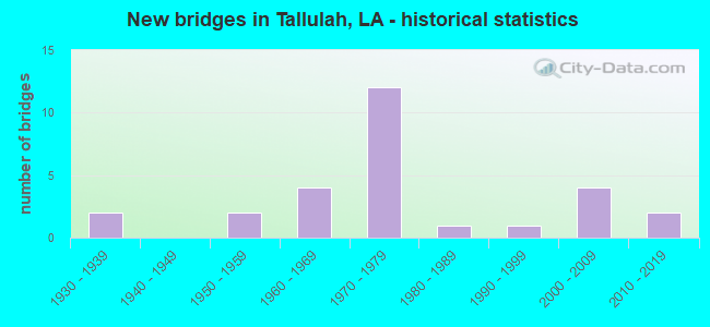
- New bridges - historical statistics
- 21930-1939
- 21950-1959
- 41960-1969
- 121970-1979
- 11980-1989
- 11990-1999
- 42000-2009
- 22010-2019


- Bridge Condition - Deck
- 8.7%Very good
- 17.4%Good
- 56.5%Satisfactory
- 13.0%Fair
- 4.3%Serious

- Bridge Condition - Superstructure
- 8.7%Very good
- 26.1%Good
- 47.8%Satisfactory
- 8.7%Fair
- 4.3%Poor
- 4.3%Serious

- Bridge Condition - Substructure
- 8.7%Very good
- 26.1%Good
- 56.5%Satisfactory
- 8.7%Fair

- Bridge Condition - Channel
- 20.8%Good
- 75.0%Satisfactory
- 4.2%Fair
Find on map >> Show street view
Structure Number: 53300000400303, Location: 1.1 MI N of US 80 (Lat: 32.410911, Lng: -91.147269), Route carried "on" structure: County highway , Year Built: 2010, Status: Open, Structure Length: 0.88m (2.89ft), Average Daily Traffic: 150 (year 2016), Average Future Daily Traffic: 255 (year 2036), Design Load: HS 20, Features Intersected: PANOLA BAYOU, Facility Carried by Structure: MERLE GUSTAFSON RD
Minimum Vertical Clearance: 30+ m (98+ ft), Kilometerpoint: 0.000, Lanes on structure: 2, Owner: County Highway Agency, Approaching Roadway Width: 6.4m (21.0ft), Material/Design: Concrete, Design/Construction: Culvert, Number Of Spans In Main Unit: 3, Length of Maximum Span: 2.7m (8.9ft)
Condition: Channel: Good, Culverts: Satisfactory, Operating Rating: 42.1 metric tons, Method Used To Determine Operating Rating: Load and Resistance Factor Rating (LRFR) rating reported by rating factor(RF) method using HL-93 loadings, Inventory Rating: 32.4 metric tons, Method Used To Determine Inventory Rating: Load and Resistance Factor Rating (LRFR) rating reported by rating factor(RF) method using HL-93 loadings, Structural Evaluation: Equal to present minimum criteria, Waterway Adequacy: Equal to present desirable criteria, Approach Roadway Alignment: Equal to present minimum criteria, Designated Inspection Frequency: Every 24 months, Inspection Date: April 2021, Deck Structure Type: Concrete Cast-file-Place
Find on map >> Show street view
Structure Number: 53300000400344, Location: 1.1 MI SW of US 65 (Lat: 32.385481, Lng: -91.208461), Route carried "on" structure: County highway , Year Built: 2010, Status: Open, Structure Length: 9.14m (29.99ft), Average Daily Traffic: 150 (year 2016), Average Future Daily Traffic: 255 (year 2036), Design Load: HS 20, Features Intersected: ROUNDAWAY BAYOU, Facility Carried by Structure: ENGLEWOOD RD
Minimum Vertical Clearance: 4.57m (14.99ft), Kilometerpoint: 0.000, Lanes on structure: 2, Owner: County Highway Agency, Approaching Roadway Width: 5.5m (18.0ft), Material/Design: Prestressed concrete continuous, Design/Construction: Stringer/Multi-beam, Number Of Spans In Main Unit: 6, Length of Maximum Span: 15.2m (49.9ft), Curb-To-Curb Width: 8.5m (27.9ft), Out-to-Out Width: 9.3m (30.5ft)
Condition: Deck: Very good, Superstructure: Very good, Substructure: Good, Channel: Good, Operating Rating: 73.5 metric tons, Method Used To Determine Operating Rating: Load Factor (LF), Inventory Rating: 43.5 metric tons, Method Used To Determine Inventory Rating: Load Factor (LF), Structural Evaluation: Better than present minimum criteria, Deck Geometry: Equal to present minimum criteria, Waterway Adequacy: Equal to present desirable criteria, Approach Roadway Alignment: Equal to present desirable criteria, Designated Inspection Frequency: Every 24 months, Inspection Date: April 2021, Deck Structure Type: Concrete Cast-file-Place, Wearing Surface/Protective System: Wearing Surface: Bituminous
Find on map >> Show street view
Structure Number: 53300020414021, Location: 10.2 MI EAST OF LA 577 (Lat: 32.435411, Lng: -91.250700), Route carried "on" structure: US 80, Year Built: 1955, Status: Open, Structure Length: 6.71m (22.01ft), Average Daily Traffic: 920 (year 2016), Truck Traffic: 15%, Average Future Daily Traffic: 1,581 (year 2036), Design Load: HS 20, Features Intersected: ROUNDAWAY BAYOU
Minimum Vertical Clearance: 30+ m (98+ ft), Kilometerpoint: 22.413, Lanes on structure: 2, Owner: State Highway Agency, Approaching Roadway Width: 10.4m (34.1ft), Material/Design: Steel, Design/Construction: Stringer/Multi-beam, Number Of Spans In Main Unit: 3, Number Of Approach Spans: 4, Length of Maximum Span: 18.3m (60.0ft), Curb-To-Curb Width: 8.5m (27.9ft), Out-to-Out Width: 10.8m (35.4ft)
Condition: Deck: Satisfactory, Superstructure: Satisfactory, Substructure: Satisfactory, Channel: Satisfactory, Operating Rating: 42.6 metric tons, Method Used To Determine Operating Rating: Load Factor (LF), Inventory Rating: 25.4 metric tons, Method Used To Determine Inventory Rating: Load Factor (LF), Structural Evaluation: Equal to present minimum criteria, Deck Geometry: Somewhat better than minimum adequacy, Waterway Adequacy: Better than present minimum criteria, Approach Roadway Alignment: Equal to present desirable criteria, Designated Inspection Frequency: Every 24 months, Underwater Inspection Frequency: Every 60 months, Inspection Date: April 2021, Underwater Inspection Date: Febuary 2018, Deck Structure Type: Concrete Cast-file-Place, Wearing Surface/Protective System: Wearing Surface: Monolithic Concrete
Find on map >> Show street view
Structure Number: 53300020417211, Location: 13.4 MI EAST OF LA 577 (Lat: 32.417519, Lng: -91.207100), Route carried "on" structure: US 80, Year Built: 1955, Status: Open, Structure Length: 2.59m (8.50ft), Average Daily Traffic: 920 (year 2016), Truck Traffic: 15%, Average Future Daily Traffic: 1,581 (year 2036), Design Load: HS 20, Features Intersected: PANOLA BAYOU
Minimum Vertical Clearance: 30+ m (98+ ft), Kilometerpoint: 27.512, Lanes on structure: 2, Owner: State Highway Agency, Approaching Roadway Width: 10.4m (34.1ft), Material/Design: Steel, Design/Construction: Stringer/Multi-beam, Number Of Spans In Main Unit: 1, Number Of Approach Spans: 2, Length of Maximum Span: 13.7m (44.9ft), Curb-To-Curb Width: 8.5m (27.9ft), Out-to-Out Width: 10.8m (35.4ft)
Condition: Deck: Fair, Superstructure: Poor, Substructure: Satisfactory, Channel: Satisfactory, Operating Rating: 42.6 metric tons, Method Used To Determine Operating Rating: Load Factor (LF), Inventory Rating: 25.4 metric tons, Method Used To Determine Inventory Rating: Load Factor (LF), Structural Evaluation: Meets minimum limits, Deck Geometry: Somewhat better than minimum adequacy, Waterway Adequacy: Equal to present minimum criteria, Approach Roadway Alignment: Equal to present desirable criteria, Length Of Structure Improvement: 3.38m (11.09ft), Designated Inspection Frequency: Every 24 months, Other Special Inspection Frequency: Every 12 months, Inspection Date: April 2021, Other Special Inspection Date: April 2020, Bridge Improvement Cost: $288,000, Total Project Cost: $432,000 ( Estimate for 2016), Deck Structure Type: Concrete Cast-file-Place, Wearing Surface/Protective System: Wearing Surface: Monolithic Concrete
Find on map >> Show street view
Structure Number: 53300200600001, Location: .1 MI SOUTH OF LA 603 (Lat: 32.228961, Lng: -91.220411), Route carried "on" structure: US 65, Year Built: 1963, Status: Open, Structure Length: 6.10m (20.01ft), Average Daily Traffic: 1,850 (year 2016), Truck Traffic: 16%, Average Future Daily Traffic: 3,196 (year 2036), Design Load: HS 20, Features Intersected: BAYOU VIDAL
Minimum Vertical Clearance: 30+ m (98+ ft), Kilometerpoint: 0.000, Lanes on structure: 2, Base Highway Network: Yes (Inventory Route: 20-06-1, Subroute: 10), Owner: State Highway Agency, Approaching Roadway Width: 13.4m (44.0ft), Material/Design: Concrete, Design/Construction: Slab, Number Of Spans In Main Unit: 10, Length of Maximum Span: 6.1m (20.0ft), Curb-To-Curb Width: 8.5m (27.9ft), Out-to-Out Width: 10.2m (33.5ft)
Condition: Deck: Fair, Superstructure: Fair, Substructure: Fair, Channel: Satisfactory, Operating Rating: 38.1 metric tons, Method Used To Determine Operating Rating: Load Factor (LF), Inventory Rating: 22.7 metric tons, Method Used To Determine Inventory Rating: Load Factor (LF), Structural Evaluation: Somewhat better than minimum adequacy, Deck Geometry: Somewhat better than minimum adequacy, Waterway Adequacy: Equal to present desirable criteria, Approach Roadway Alignment: Equal to present desirable criteria, Designated Inspection Frequency: Every 24 months, Underwater Inspection Frequency: Every 60 months, Inspection Date: April 2021, Underwater Inspection Date: November 2020, Deck Structure Type: Concrete Cast-file-Place, Wearing Surface/Protective System: Wearing Surface: Monolithic Concrete
Find on map >> Show street view
Structure Number: 53300200611001, Location: 1.5 MI NORTH OF NORTH INT (Lat: 32.375600, Lng: -91.199300), Route carried "on" structure: US 65, Year Built: 1963, Status: Open, Structure Length: 3.05m (10.01ft), Average Daily Traffic: 3,300 (year 2016), Truck Traffic: 16%, Average Future Daily Traffic: 5,610 (year 2036), Design Load: HS 20, Features Intersected: ROUNDAWAY BAYOU
Minimum Vertical Clearance: 30+ m (98+ ft), Kilometerpoint: 17.671, Lanes on structure: 2, Base Highway Network: Yes (Inventory Route: 20-06-1, Subroute: 10), Owner: State Highway Agency, Approaching Roadway Width: 13.4m (44.0ft), Material/Design: Concrete, Design/Construction: Slab, Number Of Spans In Main Unit: 5, Length of Maximum Span: 6.1m (20.0ft), Curb-To-Curb Width: 8.5m (27.9ft), Out-to-Out Width: 10.2m (33.5ft)
Condition: Deck: Satisfactory, Superstructure: Satisfactory, Substructure: Satisfactory, Channel: Satisfactory, Operating Rating: 38.1 metric tons, Method Used To Determine Operating Rating: Load Factor (LF), Inventory Rating: 22.7 metric tons, Method Used To Determine Inventory Rating: Load Factor (LF), Structural Evaluation: Equal to present minimum criteria, Deck Geometry: Meets minimum limits, Waterway Adequacy: Better than present minimum criteria, Approach Roadway Alignment: Better than present minimum criteria, Designated Inspection Frequency: Every 24 months, Inspection Date: April 2021, Deck Structure Type: Concrete Cast-file-Place, Wearing Surface/Protective System: Wearing Surface: Monolithic Concrete
Find on map >> Show street view
Structure Number: 53300200612431, Location: US 65 OVER I-20 (Lat: 32.391469, Lng: -91.199300), Route carried "on" structure: US 65, Year Built: 1975, Status: Open, Structure Length: 10.42m (34.19ft), Average Daily Traffic: 1,650 (year 2016), Truck Traffic: 9%, Average Future Daily Traffic: 3,366 (year 2036), Design Load: HS 20, Features Intersected: US 65 OVER I-20
Minimum Vertical Clearance: 30+ m (98+ ft), Kilometerpoint: 19.433, Lanes on structure: 2, Lanes under structure: 4, Base Highway Network: Yes (Inventory Route: 20-06-1, Subroute: 10), Owner: State Highway Agency, Approaching Roadway Width: 12.2m (40.0ft), Skew: 13 degrees, Material/Design: Steel continuous, Design/Construction: Stringer/Multi-beam, Number Of Spans In Main Unit: 4, Length of Maximum Span: 32.3m (106.0ft), Curb-To-Curb Width: 11.9m (39.0ft), Out-to-Out Width: 13.0m (42.7ft)
Condition: Deck: Satisfactory, Superstructure: Good, Substructure: Good, Operating Rating: 59.9 metric tons, Method Used To Determine Operating Rating: Load Factor (LF), Inventory Rating: 35.4 metric tons, Method Used To Determine Inventory Rating: Load Factor (LF), Structural Evaluation: Better than present minimum criteria, Deck Geometry: Better than present minimum criteria, Underclear: High priority of corrective action, Approach Roadway Alignment: Equal to present desirable criteria, Designated Inspection Frequency: Every 24 months, Inspection Date: March 2021, Deck Structure Type: Concrete Cast-file-Place, Wearing Surface/Protective System: Wearing Surface: Monolithic Concrete
Find on map >> Show street view
Structure Number: 53300200612432, Location: US 65 OVER I-20 (Lat: 32.392581, Lng: -91.199500), Route carried "on" structure: US 65, Year Built: 1975, Status: Open, Structure Length: 10.42m (34.19ft), Average Daily Traffic: 1,650 (year 2016), Truck Traffic: 9%, Average Future Daily Traffic: 3,366 (year 2036), Design Load: HS 20, Features Intersected: US 65 OVER I-20
Minimum Vertical Clearance: 30+ m (98+ ft), Kilometerpoint: 2.288, Lanes on structure: 2, Lanes under structure: 4, Base Highway Network: Yes (Inventory Route: 20-06-2, Subroute: 10), Owner: State Highway Agency, Approaching Roadway Width: 12.2m (40.0ft), Skew: 13 degrees, Material/Design: Steel continuous, Design/Construction: Stringer/Multi-beam, Number Of Spans In Main Unit: 2, Number Of Approach Spans: 2, Length of Maximum Span: 32.3m (106.0ft), Curb-To-Curb Width: 11.9m (39.0ft), Out-to-Out Width: 13.0m (42.7ft)
Condition: Deck: Satisfactory, Superstructure: Satisfactory, Substructure: Satisfactory, Operating Rating: 59.9 metric tons, Method Used To Determine Operating Rating: Load Factor (LF), Inventory Rating: 35.4 metric tons, Method Used To Determine Inventory Rating: Load Factor (LF), Structural Evaluation: Equal to present minimum criteria, Deck Geometry: Better than present minimum criteria, Underclear: Somewhat better than minimum adequacy, Approach Roadway Alignment: Equal to present desirable criteria, Designated Inspection Frequency: Every 24 months, Inspection Date: March 2021, Deck Structure Type: Concrete Cast-file-Place, Wearing Surface/Protective System: Wearing Surface: Monolithic Concrete
Find on map >> Show street view
Structure Number: 53300200612581, Location: .15 MI NORTH OF I-20 (Lat: 32.397761, Lng: -91.199300), Route carried "on" structure: US 65, Year Built: 1963, Status: Open, Structure Length: 6.89m (22.60ft), Average Daily Traffic: 8,900 (year 2016), Truck Traffic: 9%, Average Future Daily Traffic: 15,130 (year 2036), Design Load: HS 20, Features Intersected: WALNUT BAYOU
Minimum Vertical Clearance: 30+ m (98+ ft), Kilometerpoint: 20.130, Lanes on structure: 4, Base Highway Network: Yes (Inventory Route: 20-06-1, Subroute: 10), Owner: State Highway Agency, Approaching Roadway Width: 20.1m (65.9ft), Skew: 34 degrees, Material/Design: Concrete, Design/Construction: Slab, Number Of Spans In Main Unit: 9, Length of Maximum Span: 7.6m (24.9ft), Curb-To-Curb Width: 8.5m (27.9ft), Out-to-Out Width: 9.8m (32.2ft)
Condition: Deck: Fair, Superstructure: Fair, Substructure: Satisfactory, Channel: Satisfactory, Operating Rating: 45.4 metric tons, Method Used To Determine Operating Rating: Load Factor (LF), Inventory Rating: 27.2 metric tons, Method Used To Determine Inventory Rating: Load Factor (LF), Structural Evaluation: Somewhat better than minimum adequacy, Deck Geometry: High priority of replacement, Waterway Adequacy: Better than present minimum criteria, Approach Roadway Alignment: Equal to present minimum criteria, Length Of Structure Improvement: 7.80m (25.59ft), Designated Inspection Frequency: Every 24 months, Underwater Inspection Frequency: Every 60 months, Inspection Date: April 2021, Underwater Inspection Date: August 2020, Bridge Improvement Cost: $665,000, Total Project Cost: $997,000 ( Estimate for 2016), Deck Structure Type: Concrete Cast-file-Place, Wearing Surface/Protective System: Wearing Surface: Monolithic Concrete
Find on map >> Show street view
Structure Number: 53300200701001, Location: 1.0 MI NORTH OF US 80 (Lat: 32.421350, Lng: -91.178700), Route carried "on" structure: US 65, Year Built: 1932, Status: Open, Structure Length: 1.04m (3.41ft), Average Daily Traffic: 3,600 (year 2016), Truck Traffic: 9%, Average Future Daily Traffic: 6,290 (year 2036), Design Load: H 15, Features Intersected: PANOLA BAYOU
Minimum Vertical Clearance: 30+ m (98+ ft), Kilometerpoint: 1.613, Lanes on structure: 2, Base Highway Network: Yes (Inventory Route: 20-07-1, Subroute: 10), Owner: State Highway Agency, Approaching Roadway Width: 11.0m (36.1ft), Material/Design: Concrete, Design/Construction: Culvert, Number Of Spans In Main Unit: 5, Length of Maximum Span: 1.8m (5.9ft), Curb-To-Curb Width: 11.0m (36.1ft), Out-to-Out Width: 19.8m (65.0ft)
Condition: Channel: Satisfactory, Culverts: Satisfactory, Operating Rating: 42.1 metric tons, Method Used To Determine Operating Rating: Load and Resistance Factor Rating (LRFR) rating reported by rating factor(RF) method using HL-93 loadings, Inventory Rating: 32.4 metric tons, Method Used To Determine Inventory Rating: Load and Resistance Factor Rating (LRFR) rating reported by rating factor(RF) method using HL-93 loadings, Structural Evaluation: Equal to present minimum criteria, Deck Geometry: Somewhat better than minimum adequacy, Waterway Adequacy: Better than present minimum criteria, Approach Roadway Alignment: Equal to present desirable criteria, Designated Inspection Frequency: Every 24 months, Inspection Date: April 2021, Deck Structure Type: Concrete Cast-file-Place
Find on map >> Show street view
Structure Number: 53300200703011, Location: 3.01 MI NORTH OF US 80 (Lat: 32.444581, Lng: -91.158700), Route carried "on" structure: US 65, Year Built: 1960, Status: Open, Structure Length: 1.83m (6.00ft), Average Daily Traffic: 3,600 (year 2016), Truck Traffic: 16%, Average Future Daily Traffic: 6,290 (year 2036), Design Load: HS 20, Features Intersected: WILLOW BAYOU REL. CANAL
Minimum Vertical Clearance: 30+ m (98+ ft), Kilometerpoint: 4.815, Lanes on structure: 2, Base Highway Network: Yes (Inventory Route: 20-07-1, Subroute: 10), Owner: State Highway Agency, Approaching Roadway Width: 11.0m (36.1ft), Material/Design: Concrete, Design/Construction: Slab, Number Of Spans In Main Unit: 3, Length of Maximum Span: 6.1m (20.0ft), Curb-To-Curb Width: 8.5m (27.9ft), Out-to-Out Width: 10.2m (33.5ft)
Condition: Deck: Satisfactory, Superstructure: Satisfactory, Substructure: Satisfactory, Channel: Satisfactory, Operating Rating: 34.5 metric tons, Method Used To Determine Operating Rating: Load Factor (LF), Inventory Rating: 20.0 metric tons, Method Used To Determine Inventory Rating: Load Factor (LF), Structural Evaluation: Somewhat better than minimum adequacy, Deck Geometry: Meets minimum limits, Waterway Adequacy: Better than present minimum criteria, Approach Roadway Alignment: Equal to present desirable criteria, Designated Inspection Frequency: Every 24 months, Inspection Date: April 2021, Deck Structure Type: Concrete Cast-file-Place, Wearing Surface/Protective System: Wearing Surface: Bituminous
Find on map >> Show street view
Structure Number: 53304510811651, Location: I0020 (Lat: 32.414639, Lng: -91.274600), Route carried "on" structure: Interstate 20, Year Built: 1975, Status: Open, Structure Length: 0.67m (2.20ft), Average Daily Traffic: 22,000 (year 2016), Truck Traffic: 37%, Average Future Daily Traffic: 37,400 (year 2036), Design Load: HS 20, Features Intersected: CANAL-M32
Minimum Vertical Clearance: 30+ m (98+ ft), Kilometerpoint: 18.818, Lanes on structure: 4, Base Highway Network: Yes (Inventory Route: 451-08-1, Subroute: 10), Owner: State Highway Agency, Approaching Roadway Width: 12.8m (42.0ft), Skew: 11 degrees, Material/Design: Steel, Design/Construction: Culvert, Number Of Spans In Main Unit: 2, Length of Maximum Span: 2.7m (8.9ft), Curb-To-Curb Width: 25.6m (84.0ft), Out-to-Out Width: 84.6m (277.6ft)
Condition: Channel: Satisfactory, Culverts: Satisfactory, Operating Rating: 74.5 metric tons, Method Used To Determine Operating Rating: Load and Resistance Factor Rating (LRFR) rating reported by rating factor(RF) method using HL-93 loadings, Inventory Rating: 57.7 metric tons, Method Used To Determine Inventory Rating: Load and Resistance Factor Rating (LRFR) rating reported by rating factor(RF) method using HL-93 loadings, Structural Evaluation: Equal to present minimum criteria, Deck Geometry: Superior to present desirable criteria, Waterway Adequacy: Better than present minimum criteria, Approach Roadway Alignment: Better than present minimum criteria, Designated Inspection Frequency: Every 24 months, Inspection Date: June 2021
Find on map >> Show street view
Structure Number: 53304510813451, Location: 2.8 MI WEST OF US 65 (Lat: 32.408461, Lng: -91.244400), Route carried "on" structure: Interstate 20, Year Built: 1975, Status: Open, Structure Length: 9.14m (29.99ft), Average Daily Traffic: 11,000 (year 2016), Truck Traffic: 37%, Average Future Daily Traffic: 22,440 (year 2036), Design Load: HS 20, Features Intersected: LAKE ONE BAYOU
Minimum Vertical Clearance: 30+ m (98+ ft), Kilometerpoint: 21.749, Lanes on structure: 2, Base Highway Network: Yes (Inventory Route: 451-08-1, Subroute: 10), Owner: State Highway Agency, Approaching Roadway Width: 12.2m (40.0ft), Skew: 13 degrees, Material/Design: Concrete, Design/Construction: Slab, Number Of Spans In Main Unit: 12, Length of Maximum Span: 7.6m (24.9ft), Curb-To-Curb Width: 11.9m (39.0ft), Out-to-Out Width: 13.0m (42.7ft)
Condition: Deck: Satisfactory, Superstructure: Satisfactory, Substructure: Satisfactory, Channel: Satisfactory, Operating Rating: 75.3 metric tons, Method Used To Determine Operating Rating: Load Factor (LF), Inventory Rating: 45.4 metric tons, Method Used To Determine Inventory Rating: Load Factor (LF), Structural Evaluation: Equal to present minimum criteria, Deck Geometry: Equal to present minimum criteria, Waterway Adequacy: Equal to present desirable criteria, Approach Roadway Alignment: Equal to present desirable criteria, Designated Inspection Frequency: Every 24 months, Inspection Date: June 2021, Deck Structure Type: Concrete Cast-file-Place, Wearing Surface/Protective System: Wearing Surface: Monolithic Concrete
Find on map >> Show street view
Structure Number: 53304510813452, Location: 2.8 MI WEST OF US 65 (Lat: 32.408589, Lng: -91.243800), Route carried "on" structure: Interstate 20, Year Built: 1975, Status: Open, Structure Length: 7.62m (25.00ft), Average Daily Traffic: 11,000 (year 2016), Truck Traffic: 37%, Average Future Daily Traffic: 22,440 (year 2036), Design Load: HS 20, Features Intersected: LAKE ONE BAYOU
Minimum Vertical Clearance: 30+ m (98+ ft), Kilometerpoint: 31.268, Lanes on structure: 2, Base Highway Network: Yes (Inventory Route: 451-08-2, Subroute: 10), Owner: State Highway Agency, Approaching Roadway Width: 12.2m (40.0ft), Skew: 13 degrees, Material/Design: Concrete, Design/Construction: Slab, Number Of Spans In Main Unit: 10, Length of Maximum Span: 7.6m (24.9ft), Curb-To-Curb Width: 12.2m (40.0ft), Out-to-Out Width: 13.1m (43.0ft)
Condition: Deck: Satisfactory, Superstructure: Satisfactory, Substructure: Satisfactory, Channel: Satisfactory, Operating Rating: 75.3 metric tons, Method Used To Determine Operating Rating: Load Factor (LF), Inventory Rating: 45.4 metric tons, Method Used To Determine Inventory Rating: Load Factor (LF), Structural Evaluation: Equal to present minimum criteria, Deck Geometry: Better than present minimum criteria, Waterway Adequacy: Better than present minimum criteria, Approach Roadway Alignment: Better than present minimum criteria, Designated Inspection Frequency: Every 24 months, Inspection Date: June 2021, Deck Structure Type: Concrete Cast-file-Place, Wearing Surface/Protective System: Wearing Surface: Monolithic Concrete
Find on map >> Show street view
Structure Number: 53304510814031, Location: 2.2 MI WEST OF US 65 (Lat: 32.406481, Lng: -91.234700), Route carried "on" structure: Interstate 20, Year Built: 1975, Status: Open, Structure Length: 4.57m (14.99ft), Average Daily Traffic: 12,150 (year 2016), Truck Traffic: 37%, Average Future Daily Traffic: 24,684 (year 2036), Design Load: HS 20, Features Intersected: PANOLA BAYOU
Minimum Vertical Clearance: 30+ m (98+ ft), Kilometerpoint: 22.684, Lanes on structure: 2, Base Highway Network: Yes (Inventory Route: 451-08-1, Subroute: 10), Owner: State Highway Agency, Approaching Roadway Width: 12.2m (40.0ft), Skew: 10 degrees, Material/Design: Concrete, Design/Construction: Slab, Number Of Spans In Main Unit: 6, Length of Maximum Span: 7.6m (24.9ft), Curb-To-Curb Width: 11.9m (39.0ft), Out-to-Out Width: 13.0m (42.7ft)
Condition: Deck: Satisfactory, Superstructure: Satisfactory, Substructure: Satisfactory, Channel: Satisfactory, Operating Rating: 75.3 metric tons, Method Used To Determine Operating Rating: Load Factor (LF), Inventory Rating: 45.4 metric tons, Method Used To Determine Inventory Rating: Load Factor (LF), Structural Evaluation: Equal to present minimum criteria, Deck Geometry: Equal to present minimum criteria, Waterway Adequacy: Better than present minimum criteria, Approach Roadway Alignment: Better than present minimum criteria, Designated Inspection Frequency: Every 24 months, Inspection Date: June 2021, Deck Structure Type: Concrete Cast-file-Place, Wearing Surface/Protective System: Wearing Surface: Monolithic Concrete
Find on map >> Show street view
Structure Number: 53304510814032, Location: 2.2 MI WEST OF US 65 (Lat: 32.406619, Lng: -91.234200), Route carried "on" structure: Interstate 20, Year Built: 1975, Status: Open, Structure Length: 4.57m (14.99ft), Average Daily Traffic: 12,150 (year 2016), Truck Traffic: 37%, Average Future Daily Traffic: 24,684 (year 2036), Design Load: HS 20, Features Intersected: PANOLA BAYOU
Minimum Vertical Clearance: 30+ m (98+ ft), Kilometerpoint: 30.338, Lanes on structure: 2, Base Highway Network: Yes (Inventory Route: 451-08-2, Subroute: 10), Owner: State Highway Agency, Approaching Roadway Width: 12.8m (42.0ft), Skew: 10 degrees, Material/Design: Concrete, Design/Construction: Slab, Number Of Spans In Main Unit: 6, Length of Maximum Span: 7.6m (24.9ft), Curb-To-Curb Width: 11.9m (39.0ft), Out-to-Out Width: 13.0m (42.7ft)
Condition: Deck: Satisfactory, Superstructure: Satisfactory, Substructure: Satisfactory, Channel: Satisfactory, Operating Rating: 75.3 metric tons, Method Used To Determine Operating Rating: Load Factor (LF), Inventory Rating: 45.4 metric tons, Method Used To Determine Inventory Rating: Load Factor (LF), Structural Evaluation: Equal to present minimum criteria, Deck Geometry: Equal to present minimum criteria, Waterway Adequacy: Better than present minimum criteria, Approach Roadway Alignment: Equal to present desirable criteria, Designated Inspection Frequency: Every 24 months, Inspection Date: June 2021, Deck Structure Type: Concrete Cast-file-Place, Wearing Surface/Protective System: Wearing Surface: Monolithic Concrete
Find on map >> Show street view
Structure Number: 53304510815881, Location: .4 MI WEST OF US 65 (Lat: 32.395681, Lng: -91.206100), Route carried "on" structure: Interstate 20, Year Built: 1975, Status: Open, Structure Length: 7.68m (25.20ft), Average Daily Traffic: 12,150 (year 2016), Truck Traffic: 37%, Average Future Daily Traffic: 24,684 (year 2036), Design Load: HS 20, Features Intersected: M. P. RR
Minimum Vertical Clearance: 30+ m (98+ ft), Kilometerpoint: 25.663, Lanes on structure: 2, Base Highway Network: Yes (Inventory Route: 451-08-1, Subroute: 10), Owner: State Highway Agency, Approaching Roadway Width: 12.8m (42.0ft), Skew: 10 degrees, Material/Design: Prestressed concrete, Design/Construction: Stringer/Multi-beam, Number Of Spans In Main Unit: 5, Length of Maximum Span: 15.2m (49.9ft), Curb-To-Curb Width: 11.9m (39.0ft), Out-to-Out Width: 13.0m (42.7ft)
Condition: Deck: Good, Superstructure: Good, Substructure: Good, Operating Rating: 74.4 metric tons, Method Used To Determine Operating Rating: Load Factor (LF), Inventory Rating: 40.8 metric tons, Method Used To Determine Inventory Rating: Load Factor (LF), Structural Evaluation: Better than present minimum criteria, Deck Geometry: Equal to present minimum criteria, Underclear: Superior to present desirable criteria, Approach Roadway Alignment: Equal to present desirable criteria, Designated Inspection Frequency: Every 24 months, Inspection Date: June 2021, Deck Structure Type: Concrete Cast-file-Place, Wearing Surface/Protective System: Wearing Surface: Monolithic Concrete
Find on map >> Show street view
Structure Number: 53304510815882, Location: .4 MI WEST OF US 65 (Lat: 32.395489, Lng: -91.205200), Route carried "on" structure: Interstate 20, Year Built: 1975, Status: Open, Structure Length: 7.68m (25.20ft), Average Daily Traffic: 12,150 (year 2016), Truck Traffic: 37%, Average Future Daily Traffic: 24,684 (year 2036), Design Load: HS 20, Features Intersected: M. P. RR
Minimum Vertical Clearance: 30+ m (98+ ft), Kilometerpoint: 27.314, Lanes on structure: 2, Base Highway Network: Yes (Inventory Route: 451-08-2, Subroute: 10), Owner: State Highway Agency, Approaching Roadway Width: 12.8m (42.0ft), Skew: 10 degrees, Material/Design: Prestressed concrete, Design/Construction: Stringer/Multi-beam, Number Of Spans In Main Unit: 5, Length of Maximum Span: 15.2m (49.9ft), Curb-To-Curb Width: 11.9m (39.0ft), Out-to-Out Width: 13.0m (42.7ft)
Condition: Deck: Good, Superstructure: Good, Substructure: Good, Operating Rating: 74.4 metric tons, Method Used To Determine Operating Rating: Load Factor (LF), Inventory Rating: 40.8 metric tons, Method Used To Determine Inventory Rating: Load Factor (LF), Structural Evaluation: Better than present minimum criteria, Deck Geometry: Equal to present minimum criteria, Underclear: Superior to present desirable criteria, Approach Roadway Alignment: Equal to present desirable criteria, Designated Inspection Frequency: Every 24 months, Inspection Date: June 2021, Deck Structure Type: Concrete Cast-file-Place, Wearing Surface/Protective System: Wearing Surface: Monolithic Concrete
Find on map >> Show street view
Structure Number: 53304510816051, Location: .2 MI WEST OF US 65 (Lat: 32.394319, Lng: -91.203700), Route carried "on" structure: Interstate 20, Year Built: 1975, Status: Open, Structure Length: 12.19m (39.99ft), Average Daily Traffic: 12,150 (year 2016), Truck Traffic: 37%, Average Future Daily Traffic: 24,684 (year 2036), Design Load: HS 20, Features Intersected: OLD US 65; WALNUT BAYOU
Minimum Vertical Clearance: 30+ m (98+ ft), Kilometerpoint: 25.935, Lanes on structure: 2, Lanes under structure: 2, Base Highway Network: Yes (Inventory Route: 451-08-1, Subroute: 10), Owner: State Highway Agency, Approaching Roadway Width: 11.6m (38.1ft), Skew: 10 degrees, Material/Design: Prestressed concrete, Design/Construction: Stringer/Multi-beam, Number Of Spans In Main Unit: 7, Length of Maximum Span: 18.3m (60.0ft), Curb-To-Curb Width: 12.2m (40.0ft), Out-to-Out Width: 13.1m (43.0ft)
Condition: Deck: Satisfactory, Superstructure: Good, Substructure: Good, Channel: Satisfactory, Operating Rating: 68.0 metric tons, Method Used To Determine Operating Rating: Load Factor (LF), Inventory Rating: 37.2 metric tons, Method Used To Determine Inventory Rating: Load Factor (LF), Structural Evaluation: Better than present minimum criteria, Deck Geometry: Better than present minimum criteria, Underclear: Equal to present minimum criteria, Waterway Adequacy: Equal to present desirable criteria, Approach Roadway Alignment: Equal to present desirable criteria, Designated Inspection Frequency: Every 24 months, Underwater Inspection Frequency: Every 60 months, Inspection Date: June 2021, Underwater Inspection Date: August 2020, Deck Structure Type: Concrete Cast-file-Place
Find on map >> Show street view
Structure Number: 53304510816052, Location: .2 .1 MI EAST OF US 65 (Lat: 32.393881, Lng: -91.202400), Route carried "on" structure: Interstate 20, Year Built: 1975, Status: Open, Structure Length: 12.19m (39.99ft), Average Daily Traffic: 12,150 (year 2016), Truck Traffic: 37%, Average Future Daily Traffic: 24,684 (year 2036), Design Load: HS 20, Features Intersected: OLD US 65; WALNUT BAYOU
Minimum Vertical Clearance: 30+ m (98+ ft), Kilometerpoint: 26.992, Lanes on structure: 2, Lanes under structure: 2, Base Highway Network: Yes (Inventory Route: 451-08-2, Subroute: 10), Owner: State Highway Agency, Approaching Roadway Width: 15.2m (49.9ft), Skew: 10 degrees, Material/Design: Prestressed concrete, Design/Construction: Stringer/Multi-beam, Number Of Spans In Main Unit: 7, Length of Maximum Span: 18.3m (60.0ft), Curb-To-Curb Width: 15.6m (51.2ft), Out-to-Out Width: 16.7m (54.8ft)
Condition: Deck: Satisfactory, Superstructure: Satisfactory, Substructure: Good, Channel: Satisfactory, Operating Rating: 74.4 metric tons, Method Used To Determine Operating Rating: Load Factor (LF), Inventory Rating: 37.2 metric tons, Method Used To Determine Inventory Rating: Load Factor (LF), Structural Evaluation: Equal to present minimum criteria, Deck Geometry: Superior to present desirable criteria, Underclear: Equal to present minimum criteria, Waterway Adequacy: Equal to present desirable criteria, Approach Roadway Alignment: Equal to present desirable criteria, Designated Inspection Frequency: Every 24 months, Inspection Date: June 2021, Deck Structure Type: Concrete Cast-file-Place
Find on map >> Show street view
Structure Number: 53304510816511, Location: .01 MI WEST OF US 65 (Lat: 32.390481, Lng: -91.196900), Route carried "on" structure: Interstate 20, Year Built: 1975, Status: Open, Structure Length: 0.94m (3.08ft), Average Daily Traffic: 24,300 (year 2016), Truck Traffic: 25%, Average Future Daily Traffic: 41,140 (year 2036), Design Load: HS 20, Features Intersected: DRAIN
Minimum Vertical Clearance: 30+ m (98+ ft), Kilometerpoint: 26.701, Lanes on structure: 4, Base Highway Network: Yes (Inventory Route: 451-08-1, Subroute: 10), Owner: State Highway Agency, Approaching Roadway Width: 12.8m (42.0ft), Skew: 14 degrees, Material/Design: Concrete, Design/Construction: Culvert, Number Of Spans In Main Unit: 4, Length of Maximum Span: 2.1m (6.9ft), Curb-To-Curb Width: 25.6m (84.0ft), Out-to-Out Width: 70.3m (230.6ft)
Condition: Channel: Satisfactory, Culverts: Satisfactory, Operating Rating: 42.1 metric tons, Method Used To Determine Operating Rating: Load and Resistance Factor Rating (LRFR) rating reported by rating factor(RF) method using HL-93 loadings, Inventory Rating: 32.4 metric tons, Method Used To Determine Inventory Rating: Load and Resistance Factor Rating (LRFR) rating reported by rating factor(RF) method using HL-93 loadings, Structural Evaluation: Equal to present minimum criteria, Deck Geometry: Superior to present desirable criteria, Waterway Adequacy: Equal to present desirable criteria, Approach Roadway Alignment: Equal to present desirable criteria, Designated Inspection Frequency: Every 24 months, Inspection Date: June 2021, Deck Structure Type: Concrete Cast-file-Place
Find on map >> Show street view
Structure Number: 53308330600091, Location: .1 MI NOERTH OF I-20 (Lat: 32.406050, Lng: -91.186600), Route carried "on" structure: State highway 601, Year Built: 1937, Status: Open, Structure Length: 3.69m (12.11ft), Average Daily Traffic: 6,000 (year 2016), Truck Traffic: 8%, Average Future Daily Traffic: 10,200 (year 2036), Design Load: H 15, Features Intersected: BRUSHY BAYOU
Minimum Vertical Clearance: 30+ m (98+ ft), Kilometerpoint: 0.249, Lanes on structure: 2, Owner: State Highway Agency, Approaching Roadway Width: 11.9m (39.0ft), Material/Design: Concrete, Design/Construction: Tee Beam, Number Of Spans In Main Unit: 5, Length of Maximum Span: 7.3m (24.0ft), Curb or Sidewalk Widths: Left: 1.2m (3.9ft), Right: 1.2m (3.9ft), Curb-To-Curb Width: 6.1m (20.0ft), Out-to-Out Width: 9.9m (32.5ft)
Condition: Deck: Satisfactory, Superstructure: Satisfactory, Substructure: Fair, Channel: Satisfactory, Operating Rating: 59.9 metric tons, Method Used To Determine Operating Rating: Allowable Stress (AS), Inventory Rating: 35.4 metric tons, Method Used To Determine Inventory Rating: Allowable Stress (AS), Structural Evaluation: Somewhat better than minimum adequacy, Deck Geometry: High priority of replacement, Waterway Adequacy: Equal to present desirable criteria, Approach Roadway Alignment: Equal to present minimum criteria, Length Of Structure Improvement: 4.60m (15.09ft), Designated Inspection Frequency: Every 24 months, Inspection Date: April 2021, Bridge Improvement Cost: $392,000, Total Project Cost: $588,000 ( Estimate for 2016), Deck Structure Type: Concrete Cast-file-Place, Wearing Surface/Protective System: Wearing Surface: Monolithic Concrete
Find on map >> Show street view
Structure Number: 53332210910111, Location: 0.1 MI E of US 65 (Lat: 32.351961, Lng: -91.018531), Route carried "on" structure: County highway , Year Built: 2006, Status: Open, Structure Length: 2.44m (8.01ft), Average Daily Traffic: 125 (year 2016), Average Future Daily Traffic: 212 (year 2036), Design Load: HS 20, Features Intersected: CYPRESS BAYOU, Facility Carried by Structure: VTR AIRPORT RD
Minimum Vertical Clearance: 30+ m (98+ ft), Kilometerpoint: 0.000, Lanes on structure: 2, Base Highway Network: Yes, Owner: County Highway Agency, Approaching Roadway Width: 8.5m (27.9ft), Material/Design: Concrete, Design/Construction: Slab, Number Of Spans In Main Unit: 4, Length of Maximum Span: 6.1m (20.0ft), Curb-To-Curb Width: 8.5m (27.9ft), Out-to-Out Width: 9.3m (30.5ft)
Condition: Deck: Good, Superstructure: Good, Substructure: Very good, Channel: Satisfactory, Operating Rating: 45.7 metric tons, Method Used To Determine Operating Rating: Load and Resistance Factor Rating (LRFR) rating reported by rating factor(RF) method using HL-93 loadings, Inventory Rating: 35.3 metric tons, Method Used To Determine Inventory Rating: Load and Resistance Factor Rating (LRFR) rating reported by rating factor(RF) method using HL-93 loadings, Structural Evaluation: Better than present minimum criteria, Deck Geometry: Equal to present minimum criteria, Waterway Adequacy: Equal to present desirable criteria, Approach Roadway Alignment: Equal to present desirable criteria, Designated Inspection Frequency: Every 24 months, Inspection Date: April 2021, Deck Structure Type: Concrete Precast Panels
Find on map >> Show street view
Structure Number: 53332239911181, Location: 0.3 MI SW of US 80 (Lat: 32.401719, Lng: -91.193881), Route carried "on" structure: County highway , Year Built: 1983, Status: Open, Structure Length: 5.70m (18.70ft), Average Daily Traffic: 500 (year 1980), Average Future Daily Traffic: 850 (year 2036), Design Load: HS 20, Features Intersected: BRUSHY BAYOU, Facility Carried by Structure: MISSISSIPPI ST.
Minimum Vertical Clearance: 30+ m (98+ ft), Kilometerpoint: 0.000, Lanes on structure: 2, Owner: County Highway Agency, Approaching Roadway Width: 6.1m (20.0ft), Material/Design: Concrete, Design/Construction: Slab, Number Of Spans In Main Unit: 11, Length of Maximum Span: 5.8m (19.0ft), Curb or Sidewalk Widths: Left: 0.0m, Right: 1.3m (4.3ft), Curb-To-Curb Width: 9.8m (32.2ft), Out-to-Out Width: 11.9m (39.0ft)
Condition: Deck: Serious, Superstructure: Serious, Substructure: Satisfactory, Channel: Satisfactory, Operating Rating: 42.1 metric tons, Method Used To Determine Operating Rating: Load and Resistance Factor Rating (LRFR) rating reported by rating factor(RF) method using HL-93 loadings, Inventory Rating: 32.7 metric tons, Method Used To Determine Inventory Rating: Load and Resistance Factor Rating (LRFR) rating reported by rating factor(RF) method using HL-93 loadings, Structural Evaluation: High priority of corrective action, Deck Geometry: Equal to present minimum criteria, Waterway Adequacy: Equal to present desirable criteria, Approach Roadway Alignment: Equal to present desirable criteria, Designated Inspection Frequency: Every 24 months, Underwater Inspection Frequency: Every 60 months, Inspection Date: April 2021, Underwater Inspection Date: Febuary 2018, Deck Structure Type: Concrete Precast Panels
Find on map >> Show street view
Structure Number: 53332241911071, Location: 0.08 MI SW of US 80 (Lat: 32.400169, Lng: -91.161969), Route carried "on" structure: County highway , Year Built: 2007, Status: Open, Structure Length: 3.05m (10.01ft), Average Daily Traffic: 60 (year 2016), Average Future Daily Traffic: 102 (year 2036), Design Load: HS 20, Features Intersected: WALNUT BAYOU, Facility Carried by Structure: SILVER CROSS RD
Minimum Vertical Clearance: 30+ m (98+ ft), Kilometerpoint: 0.000, Lanes on structure: 2, Base Highway Network: Yes, Owner: County Highway Agency, Approaching Roadway Width: 6.7m (22.0ft), Material/Design: Concrete, Design/Construction: Slab, Number Of Spans In Main Unit: 5, Length of Maximum Span: 6.1m (20.0ft), Curb-To-Curb Width: 7.3m (24.0ft), Out-to-Out Width: 8.1m (26.6ft)
Condition: Deck: Very good, Superstructure: Very good, Substructure: Satisfactory, Channel: Good, Operating Rating: 48.0 metric tons, Method Used To Determine Operating Rating: Load and Resistance Factor Rating (LRFR) rating reported by rating factor(RF) method using HL-93 loadings, Inventory Rating: 45.7 metric tons, Method Used To Determine Inventory Rating: Load and Resistance Factor Rating (LRFR) rating reported by rating factor(RF) method using HL-93 loadings, Structural Evaluation: Equal to present minimum criteria, Deck Geometry: Equal to present minimum criteria, Waterway Adequacy: Equal to present desirable criteria, Approach Roadway Alignment: Equal to present desirable criteria, Designated Inspection Frequency: Every 24 months, Inspection Date: April 2021, Deck Structure Type: Concrete Precast Panels
Find on map >> Show street view
Structure Number: 53332242911061, Location: 0.08 MI S of US 80 (Lat: 32.403650, Lng: -91.169439), Route carried "on" structure: County highway , Year Built: 2006, Status: Open, Structure Length: 3.66m (12.01ft), Average Daily Traffic: 50 (year 2016), Average Future Daily Traffic: 85 (year 2036), Design Load: HS 20, Features Intersected: WALNUT BAYOU, Facility Carried by Structure: STOCKLAND RD
Minimum Vertical Clearance: 30+ m (98+ ft), Kilometerpoint: 0.000, Lanes on structure: 2, Base Highway Network: Yes, Owner: County Highway Agency, Approaching Roadway Width: 7.6m (24.9ft), Material/Design: Concrete, Design/Construction: Slab, Number Of Spans In Main Unit: 6, Length of Maximum Span: 6.1m (20.0ft), Curb-To-Curb Width: 8.5m (27.9ft), Out-to-Out Width: 9.3m (30.5ft)
Condition: Deck: Good, Superstructure: Good, Substructure: Very good, Channel: Good, Operating Rating: 48.0 metric tons, Method Used To Determine Operating Rating: Load and Resistance Factor Rating (LRFR) rating reported by rating factor(RF) method using HL-93 loadings, Inventory Rating: 36.9 metric tons, Method Used To Determine Inventory Rating: Load and Resistance Factor Rating (LRFR) rating reported by rating factor(RF) method using HL-93 loadings, Structural Evaluation: Better than present minimum criteria, Deck Geometry: Better than present minimum criteria, Waterway Adequacy: Equal to present desirable criteria, Approach Roadway Alignment: Equal to present desirable criteria, Designated Inspection Frequency: Every 24 months, Inspection Date: April 2021, Deck Structure Type: Concrete Cast-file-Place
Find on map >> Show street view
Structure Number: 53332243911051, Location: 0.08 MI S of US 80 (Lat: 32.406700, Lng: -91.174600), Route carried "on" structure: County highway , Year Built: 2003, Status: Open, Structure Length: 2.99m (9.81ft), Average Daily Traffic: 3,400 (year 2000), Average Future Daily Traffic: 5,780 (year 2036), Design Load: HS 20, Features Intersected: BRUSHY BAYOU, Facility Carried by Structure: KIMBROUGH ST
Minimum Vertical Clearance: 30+ m (98+ ft), Kilometerpoint: 0.000, Lanes on structure: 2, Base Highway Network: Yes, Owner: County Highway Agency, Approaching Roadway Width: 6.7m (22.0ft), Material/Design: Concrete, Design/Construction: Slab, Number Of Spans In Main Unit: 5, Length of Maximum Span: 6.1m (20.0ft), Curb-To-Curb Width: 7.3m (24.0ft), Out-to-Out Width: 8.1m (26.6ft)
Condition: Deck: Satisfactory, Superstructure: Satisfactory, Substructure: Satisfactory, Channel: Good, Operating Rating: 45.4 metric tons, Method Used To Determine Operating Rating: Load and Resistance Factor Rating (LRFR) rating reported by rating factor(RF) method using HL-93 loadings, Inventory Rating: 35.0 metric tons, Method Used To Determine Inventory Rating: Load and Resistance Factor Rating (LRFR) rating reported by rating factor(RF) method using HL-93 loadings, Structural Evaluation: Equal to present minimum criteria, Deck Geometry: High priority of replacement, Waterway Adequacy: Equal to present desirable criteria, Approach Roadway Alignment: Equal to present desirable criteria, Length Of Structure Improvement: 3.81m (12.50ft), Designated Inspection Frequency: Every 24 months, Underwater Inspection Frequency: Every 60 months, Inspection Date: April 2021, Underwater Inspection Date: January 2020, Bridge Improvement Cost: $227,000, Total Project Cost: $340,000 ( Estimate for 2016), Deck Structure Type: Concrete Cast-file-Place
Find on map >> Show street view
Structure Number: 53332248911021, Location: 0.8 MI N of US 80 (Lat: 32.416881, Lng: -91.169819), Route carried "on" structure: County highway , Year Built: 1997, Status: Open, Structure Length: 1.07m (3.51ft), Average Daily Traffic: 225 (year 1979), Average Future Daily Traffic: 382 (year 2036), Design Load: HS 20, Features Intersected: BONE CREEK, Facility Carried by Structure: BAILEY RD
Minimum Vertical Clearance: 30+ m (98+ ft), Kilometerpoint: 0.000, Lanes on structure: 2, Base Highway Network: Yes, Owner: County Highway Agency, Approaching Roadway Width: 10.4m (34.1ft), Skew: 7 degrees, Material/Design: Concrete, Design/Construction: Culvert, Number Of Spans In Main Unit: 4, Length of Maximum Span: 2.4m (7.9ft)
Condition: Channel: Fair, Culverts: Satisfactory, Operating Rating: 42.1 metric tons, Method Used To Determine Operating Rating: Load and Resistance Factor Rating (LRFR) rating reported by rating factor(RF) method using HL-93 loadings, Inventory Rating: 32.4 metric tons, Method Used To Determine Inventory Rating: Load and Resistance Factor Rating (LRFR) rating reported by rating factor(RF) method using HL-93 loadings, Structural Evaluation: Equal to present minimum criteria, Waterway Adequacy: Equal to present desirable criteria, Approach Roadway Alignment: Equal to present desirable criteria, Designated Inspection Frequency: Every 24 months, Inspection Date: April 2021, Deck Structure Type: Concrete Cast-file-Place
Find on map >> Show street view
Structure Number: 53300200612431, Location: 1.7 MI W OF LA 602 (Lat: 32.391819, Lng: -91.199289), Route carried "under" structure: Interstate 20, Structure Length: 0. m, Average Daily Traffic: 1,980 (year 2015), Features Intersected: I-20 EB UNDER US 65 NB
Minimum Vertical Clearance: 5.09m (16.70ft), Kilometerpoint: 26.432, Lanes on structure: 2, Length of Maximum Span: 0.0m
Find on map >> Show street view
Structure Number: 53300200612431, Location: 1.7 MI W OF LA 602 (Lat: 32.392050, Lng: -91.199150), Route carried "under" structure: Interstate 20, Structure Length: 0. m, Average Daily Traffic: 1,980 (year 2015), Features Intersected: I-20 WB UNDER US 65 NB
Minimum Vertical Clearance: 5.18m (16.99ft), Kilometerpoint: 26.625, Lanes on structure: 2, Length of Maximum Span: 0.0m
Find on map >> Show street view
Structure Number: 53300200612432, Location: 1.7 MI W OF LA 602 (Lat: 32.391950, Lng: -91.199519), Route carried "under" structure: Interstate 20, Structure Length: 0. m, Average Daily Traffic: 1,980 (year 2015), Features Intersected: I-20 UNDER US 65
Minimum Vertical Clearance: 5.27m (17.29ft), Kilometerpoint: 26.406, Lanes on structure: 2, Length of Maximum Span: 0.0m
Find on map >> Show street view
Structure Number: 53300200612432, Location: 1.7 MI W OF LA 602 (Lat: 32.392261, Lng: -91.199519), Route carried "under" structure: Interstate 20, Structure Length: 0. m, Average Daily Traffic: 1,980 (year 2015), Features Intersected: I-20 WB UNDER US 65 SB
Minimum Vertical Clearance: 5.09m (16.70ft), Kilometerpoint: 26.668, Lanes on structure: 2, Length of Maximum Span: 0.0m