Bridge Statistics for Telford, Pennsylvania (PA)
Condition, Traffic, Stress, Structural Evaluation, Project Costs
- National Bridge Inventory (NBI) Statistics
- 19Number of bridges
- 135ft / 41.0mTotal length
- $5,115,000Total costs
- 237,340Total average daily traffic
- 23,951Total average daily truck traffic
- National Bridge Inventory (NBI) Registered Bridges for Telford
- No street view available for this location
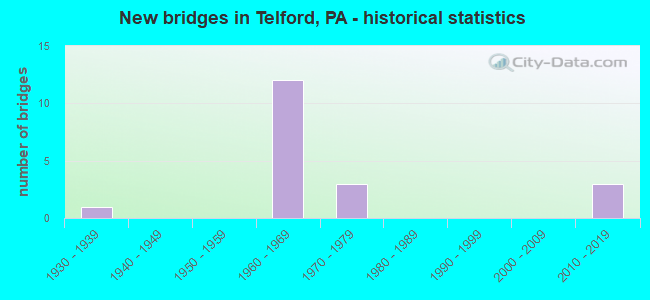
- New bridges - historical statistics
- 11930-1939
- 121960-1969
- 31970-1979
- 32010-2019

- Reconstructed bridges - Historical Statistics
- 31970-1979
- 01980-1989
- 01990-1999
- 02000-2009
- 12010-2019


- Bridge Condition - Deck
- 45.5%Very good
- 36.4%Satisfactory
- 18.2%Fair

- Bridge Condition - Superstructure
- 18.2%Very good
- 18.2%Good
- 9.1%Satisfactory
- 45.5%Fair
- 9.1%Poor

- Bridge Condition - Substructure
- 18.2%Very good
- 9.1%Good
- 36.4%Satisfactory
- 18.2%Fair
- 9.1%Poor
- 9.1%Critical

- Bridge Condition - Channel
- 16.7%Satisfactory
- 33.3%Fair
- 50.0%Poor
Find on map >> Show street view
Structure Number: 6968, Location: .4MILES TO LR 270 20E10 (Lat: 40.322850, Lng: -75.310378), Route carried "on" structure: State highway 309, Year Built: 1967, Status: Open, Structure Length: 1.40m (4.59ft), Average Daily Traffic: 27,793 (year 2020), Truck Traffic: 9%, Average Future Daily Traffic: 41,284 (year 2032), Design Load: HS 20, Features Intersected: CENTRAL AVE(T425)/2920A9, Facility Carried by Structure: SELLERSVILLE BYPAS
Minimum Vertical Clearance: 30+ m (98+ ft), Kilometerpoint: 5.848, Lanes on structure: 2, Lanes under structure: 2, Base Highway Network: Yes, Owner: State Highway Agency, Approaching Roadway Width: 25.6m (84.0ft), Skew: 31 degrees, Material/Design: Prestressed concrete, Design/Construction: Stringer/Multi-beam, Number Of Spans In Main Unit: 1, Length of Maximum Span: 13.4m (44.0ft), Curb or Sidewalk Widths: Left: 0.2m (0.7ft), Right: 0.2m (0.7ft), Curb-To-Curb Width: 25.6m (84.0ft), Out-to-Out Width: 26.5m (86.9ft)
Condition: Deck: Very good, Superstructure: Good, Substructure: Good, Operating Rating: 67.1 metric tons, Method Used To Determine Operating Rating: Load Factor (LF), Inventory Rating: 32.7 metric tons, Method Used To Determine Inventory Rating: Load Factor (LF), Structural Evaluation: Better than present minimum criteria, Deck Geometry: Superior to present desirable criteria, Underclear: Meets minimum limits, Approach Roadway Alignment: Equal to present desirable criteria, Length Of Structure Improvement: 2.00m (6.56ft), Designated Inspection Frequency: Every 24 months, Inspection Date: June 2021, Deck Structure Type: Concrete Cast-file-Place, Wearing Surface/Protective System: Wearing Surface: Latex Concrete
Find on map >> Show street view
Structure Number: 6969, Location: 1MILES TO LR 356 20E08 (Lat: 40.329581, Lng: -75.310133), Route carried "on" structure: State highway 309, Year Built: 1967, Status: Open, Structure Length: 1.25m (4.10ft), Average Daily Traffic: 27,793 (year 2020), Truck Traffic: 9%, Average Future Daily Traffic: 41,284 (year 2032), Design Load: HS 20, Features Intersected: RELIANCE ROAD(T427), Facility Carried by Structure: SELLERSVILLE BYPAS
Minimum Vertical Clearance: 30+ m (98+ ft), Kilometerpoint: 6.602, Lanes on structure: 4, Lanes under structure: 2, Base Highway Network: Yes, Owner: State Highway Agency, Approaching Roadway Width: 25.6m (84.0ft), Skew: 33 degrees, Material/Design: Prestressed concrete, Design/Construction: Stringer/Multi-beam, Number Of Spans In Main Unit: 1, Length of Maximum Span: 11.9m (39.0ft), Curb or Sidewalk Widths: Left: 0.2m (0.7ft), Right: 0.2m (0.7ft), Curb-To-Curb Width: 24.4m (80.1ft), Out-to-Out Width: 26.5m (86.9ft)
Condition: Deck: Very good, Superstructure: Good, Substructure: Satisfactory, Operating Rating: 59.0 metric tons, Method Used To Determine Operating Rating: Load Factor (LF), Inventory Rating: 29.0 metric tons, Method Used To Determine Inventory Rating: Load Factor (LF), Structural Evaluation: Equal to present minimum criteria, Deck Geometry: Superior to present desirable criteria, Underclear: High priority of corrective action, Approach Roadway Alignment: Equal to present desirable criteria, Length Of Structure Improvement: 1.90m (6.23ft), Designated Inspection Frequency: Every 24 months, Inspection Date: June 2021, Deck Structure Type: Concrete Cast-file-Place, Wearing Surface/Protective System: Wearing Surface: Latex Concrete
Find on map >> Show street view
Structure Number: 6971, Location: EAST OF TELFORD 20D07 (Lat: 40.339481, Lng: -75.314586), Route carried "on" structure: State highway 309, Year Built: 1967, Year Reconstructed: 1982, Status: Open, Structure Length: 3.84m (12.60ft), Average Daily Traffic: 27,793 (year 2020), Truck Traffic: 9%, Average Future Daily Traffic: 41,284 (year 2032), Design Load: HS 20, Features Intersected: SEPTA (BETHLEHEM BRANCH)
Minimum Vertical Clearance: 30+ m (98+ ft), Kilometerpoint: 7.796, Lanes on structure: 2, Base Highway Network: Yes, Owner: State Highway Agency, Approaching Roadway Width: 26.8m (87.9ft), Skew: 32 degrees, Material/Design: Prestressed concrete, Design/Construction: Box Beam or Girders - Multiple, Number Of Spans In Main Unit: 1, Number Of Approach Spans: 2, Length of Maximum Span: 15.5m (50.9ft), Curb or Sidewalk Widths: Left: 0.2m (0.7ft), Right: 0.2m (0.7ft), Curb-To-Curb Width: 25.9m (85.0ft), Out-to-Out Width: 27.3m (89.6ft)
Condition: Deck: Satisfactory, Superstructure: Fair, Substructure: Fair, Operating Rating: 44.5 metric tons, Method Used To Determine Operating Rating: Load Factor (LF), Inventory Rating: 26.3 metric tons, Method Used To Determine Inventory Rating: Load Factor (LF), Structural Evaluation: Somewhat better than minimum adequacy, Deck Geometry: Superior to present desirable criteria, Underclear: High priority of corrective action, Approach Roadway Alignment: Equal to present desirable criteria, Length Of Structure Improvement: 4.60m (15.09ft), Designated Inspection Frequency: Every 24 months, Inspection Date: June 2021, Bridge Improvement Cost: $33,000, Roadway Improvement Cost: $98,000, Total Project Cost: $450,000, Deck Structure Type: Concrete Cast-file-Place, Wearing Surface/Protective System: Wearing Surface: Latex Concrete
Find on map >> Show street view
Structure Number: 6972, Location: EAST OF TELFORD 20D06 (Lat: 40.342731, Lng: -75.317811), Route carried "on" structure: State highway 309, Year Built: 1967, Year Reconstructed: 1982, Status: Open, Structure Length: 2.23m (7.32ft), Average Daily Traffic: 35,081 (year 2022), Truck Traffic: 9%, Average Future Daily Traffic: 43,982 (year 2032), Design Load: HS 20, Features Intersected: STATE ROAD, Facility Carried by Structure: SELLERSVILLE BYPAS
Minimum Vertical Clearance: 30+ m (98+ ft), Kilometerpoint: 8.258, Lanes on structure: 2, Lanes under structure: 8, Base Highway Network: Yes, Owner: State Highway Agency, Approaching Roadway Width: 26.8m (87.9ft), Skew: 31 degrees, Material/Design: Prestressed concrete, Design/Construction: Box Beam or Girders - Multiple, Number Of Spans In Main Unit: 1, Length of Maximum Span: 21.9m (71.9ft), Curb or Sidewalk Widths: Left: 0.2m (0.7ft), Right: 0.2m (0.7ft), Curb-To-Curb Width: 25.6m (84.0ft), Out-to-Out Width: 27.4m (89.9ft)
Condition: Deck: Satisfactory, Superstructure: Fair, Substructure: Satisfactory, Operating Rating: 88.0 metric tons, Method Used To Determine Operating Rating: Load Factor (LF), Inventory Rating: 39.9 metric tons, Method Used To Determine Inventory Rating: Load Factor (LF), Structural Evaluation: Somewhat better than minimum adequacy, Deck Geometry: Superior to present desirable criteria, Underclear: Somewhat better than minimum adequacy, Approach Roadway Alignment: Equal to present desirable criteria, Length Of Structure Improvement: 2.90m (9.51ft), Designated Inspection Frequency: Every 24 months, Inspection Date: June 2021, Bridge Improvement Cost: $19,000, Roadway Improvement Cost: $55,000, Total Project Cost: $254,000, Deck Structure Type: Concrete Cast-file-Place, Wearing Surface/Protective System: Wearing Surface: Latex Concrete
Find on map >> Show street view
Structure Number: 6973, Location: .4MI.TO LR 09104 20C05 (Lat: 40.347039, Lng: -75.325322), Route carried "on" structure: State highway 309, Year Built: 1967, Year Reconstructed: 1982, Status: Open, Structure Length: 5.21m (17.09ft), Average Daily Traffic: 35,081 (year 2022), Truck Traffic: 9%, Average Future Daily Traffic: 43,982 (year 2032), Design Load: HS 20, Features Intersected: N.E.BRANCH PERKIOMEN CR, Facility Carried by Structure: SELLERSVILLE BYPAS
Minimum Vertical Clearance: 30+ m (98+ ft), Kilometerpoint: 9.035, Lanes on structure: 4, Base Highway Network: Yes, Owner: State Highway Agency, Approaching Roadway Width: 26.8m (87.9ft), Skew: 32 degrees, Material/Design: Prestressed concrete, Design/Construction: Box Beam or Girders - Single/Spread, Number Of Spans In Main Unit: 3, Length of Maximum Span: 19.5m (64.0ft), Curb or Sidewalk Widths: Left: 0.2m (0.7ft), Right: 0.2m (0.7ft), Curb-To-Curb Width: 25.6m (84.0ft), Out-to-Out Width: 27.3m (89.6ft)
Condition: Deck: Satisfactory, Superstructure: Poor, Substructure: Poor, Channel: Fair, Operating Rating: 55.3 metric tons, Method Used To Determine Operating Rating: Load Factor (LF), Inventory Rating: 29.0 metric tons, Method Used To Determine Inventory Rating: Load Factor (LF), Structural Evaluation: Meets minimum limits, Deck Geometry: Superior to present desirable criteria, Waterway Adequacy: Equal to present minimum criteria, Approach Roadway Alignment: Equal to present desirable criteria, Length Of Structure Improvement: 5.20m (17.06ft), Designated Inspection Frequency: Every 24 months, Inspection Date: April 2021, Bridge Improvement Cost: $111,000, Roadway Improvement Cost: $326,000, Total Project Cost: $1,495,000, Deck Structure Type: Concrete Cast-file-Place, Wearing Surface/Protective System: Wearing Surface: Latex Concrete
Find on map >> Show street view
Structure Number: 74, Location: 2.MI.S.SELLERSVILL 19J07 (Lat: 40.340228, Lng: -75.353292), Route carried "on" structure: State highway , Year Built: 1932, Status: Open, Structure Length: 6.04m (19.82ft), Average Daily Traffic: 3,780 (year 2022), Truck Traffic: 10%, Average Future Daily Traffic: 4,504 (year 2032), Design Load: H 20, Features Intersected: N.E.BR PERKIOMEN CREEK, Facility Carried by Structure: COUNTY LINE RD
Minimum Vertical Clearance: 30+ m (98+ ft), Kilometerpoint: 5.481, Lanes on structure: 2, Owner: State Highway Agency, Approaching Roadway Width: 8.8m (28.9ft), Material/Design: Steel, Design/Construction: Stringer/Multi-beam, Number Of Spans In Main Unit: 4, Length of Maximum Span: 14.0m (45.9ft), Curb or Sidewalk Widths: Left: 0.0m, Right: 1.3m (4.3ft), Curb-To-Curb Width: 7.4m (24.3ft), Out-to-Out Width: 9.8m (32.2ft)
Condition: Deck: Fair, Superstructure: Fair, Substructure: Fair, Channel: Poor, Operating Rating: 63.5 metric tons, Method Used To Determine Operating Rating: Load Factor (LF), Inventory Rating: 38.1 metric tons, Method Used To Determine Inventory Rating: Load Factor (LF), Structural Evaluation: Somewhat better than minimum adequacy, Deck Geometry: High priority of replacement, Waterway Adequacy: Equal to present minimum criteria, Approach Roadway Alignment: Equal to present desirable criteria, Length Of Structure Improvement: 7.10m (23.29ft), Designated Inspection Frequency: Every 24 months, Inspection Date: September 2021, Bridge Improvement Cost: $187,000, Roadway Improvement Cost: $550,000, Total Project Cost: $2,522,000, Deck Structure Type: Concrete Cast-file-Place, Wearing Surface/Protective System: Wearing Surface: Bituminous
Find on map >> Show street view
Structure Number: 7408, Location: 1.8MI.W.SELLERSVI. 20A06 (Lat: 40.343028, Lng: -75.336647), Route carried "on" structure: State highway , Year Built: 1970, Status: Open, Structure Length: 4.11m (13.48ft), Average Daily Traffic: 1,833 (year 2022), Truck Traffic: 5%, Average Future Daily Traffic: 3,093 (year 2032), Design Load: HS 20, Features Intersected: EAST BR.PERKIOMEN CREEK, Facility Carried by Structure: CATHILL ROAD
Minimum Vertical Clearance: 30+ m (98+ ft), Kilometerpoint: 1.204, Lanes on structure: 2, Owner: State Highway Agency, Approaching Roadway Width: 13.7m (44.9ft), Skew: 1 degrees, Material/Design: Prestressed concrete, Design/Construction: Box Beam or Girders - Multiple, Number Of Spans In Main Unit: 2, Length of Maximum Span: 20.1m (65.9ft), Curb or Sidewalk Widths: Left: 0.2m (0.7ft), Right: 0.2m (0.7ft), Curb-To-Curb Width: 13.4m (44.0ft), Out-to-Out Width: 14.7m (48.2ft)
Condition: Deck: Very good, Superstructure: Fair, Substructure: Satisfactory, Channel: Fair, Operating Rating: 81.6 metric tons, Method Used To Determine Operating Rating: Load Factor (LF), Inventory Rating: 28.1 metric tons, Method Used To Determine Inventory Rating: Load Factor (LF), Structural Evaluation: Somewhat better than minimum adequacy, Deck Geometry: Equal to present desirable criteria, Waterway Adequacy: Equal to present minimum criteria, Approach Roadway Alignment: Better than present minimum criteria, Length Of Structure Improvement: 5.00m (16.40ft), Designated Inspection Frequency: Every 24 months, Inspection Date: June 2021, Bridge Improvement Cost: $29,000, Roadway Improvement Cost: $86,000, Total Project Cost: $394,000, Deck Structure Type: Concrete Cast-file-Place, Wearing Surface/Protective System: Wearing Surface: Latex Concrete
Find on map >> Show street view
Structure Number: 27542, Location: FRANCONIA 08H07 (Lat: 40.337594, Lng: -75.357411), Route carried "on" structure: State highway , Year Built: 1967, Year Reconstructed: 2017, Status: Open, Structure Length: 3.23m (10.60ft), Average Daily Traffic: 518 (year 2022), Truck Traffic: 5%, Average Future Daily Traffic: 1,312 (year 2032), Design Load: HS 20, Features Intersected: EAST BR.PERKIOMEN CREEK, Facility Carried by Structure: COWPATH ROAD
Minimum Vertical Clearance: 30+ m (98+ ft), Kilometerpoint: 3.269, Lanes on structure: 2, Owner: State Highway Agency, Approaching Roadway Width: 8.5m (27.9ft), Skew: 1 degrees, Material/Design: Prestressed concrete, Design/Construction: Box Beam or Girders - Single/Spread, Number Of Spans In Main Unit: 2, Length of Maximum Span: 15.8m (51.8ft), Curb or Sidewalk Widths: Left: 0.5m (1.6ft), Right: 0.5m (1.6ft), Curb-To-Curb Width: 8.5m (27.9ft), Out-to-Out Width: 10.2m (33.5ft)
Condition: Deck: Satisfactory, Superstructure: Satisfactory, Substructure: Satisfactory, Channel: Satisfactory, Operating Rating: 59.0 metric tons, Method Used To Determine Operating Rating: Load Factor (LF), Inventory Rating: 26.3 metric tons, Method Used To Determine Inventory Rating: Load Factor (LF), Structural Evaluation: Equal to present minimum criteria, Deck Geometry: Somewhat better than minimum adequacy, Waterway Adequacy: Equal to present desirable criteria, Approach Roadway Alignment: Better than present minimum criteria, Length Of Structure Improvement: 3.90m (12.80ft), Designated Inspection Frequency: Every 24 months, Inspection Date: July 2021, Deck Structure Type: Concrete Cast-file-Place, Wearing Surface/Protective System: Wearing Surface: Latex Concrete, Deck Protection: Epoxy Coated Reinforcing
Find on map >> Show street view
Structure Number: 4854, Location: 3.25 MI. W. PA-309 2918H5 (Lat: 40.349403, Lng: -75.390122), Route carried "on" structure: State highway 563, Year Built: 2014, Status: Open, Structure Length: 7.13m (23.39ft), Average Daily Traffic: 5,684 (year 2022), Truck Traffic: 11%, Average Future Daily Traffic: 6,896 (year 2030), Design Load: HL 93, Features Intersected: PA TPK (I-476), Facility Carried by Structure: RIDGE ROAD
Minimum Vertical Clearance: 30.18m (99.02ft), Kilometerpoint: 6.222, Lanes on structure: 2, Lanes under structure: 6, Owner: State Highway Agency, Approaching Roadway Width: 12.2m (40.0ft), Material/Design: Prestressed concrete continuous, Design/Construction: Stringer/Multi-beam, Number Of Spans In Main Unit: 2, Length of Maximum Span: 36.6m (120.1ft), Curb or Sidewalk Widths: Left: 0.2m (0.7ft), Right: 0.2m (0.7ft), Curb-To-Curb Width: 12.2m (40.0ft), Out-to-Out Width: 13.2m (43.3ft)
Condition: Deck: Very good, Superstructure: Very good, Substructure: Very good, Operating Rating: 58.3 metric tons, Method Used To Determine Operating Rating: Assigned ratings based on Load and Resistance Factor Design (LRFD) reported by rating factor (RF) using HL93 loadings, Inventory Rating: 36.6 metric tons, Method Used To Determine Inventory Rating: Assigned ratings based on Load and Resistance Factor Design (LRFD) reported by rating factor (RF) using HL93 loadings, Structural Evaluation: Equal to present desirable criteria, Deck Geometry: Somewhat better than minimum adequacy, Underclear: Equal to present minimum criteria, Approach Roadway Alignment: Equal to present desirable criteria, Designated Inspection Frequency: Every 48 months, Inspection Date: October 2019, Deck Structure Type: Concrete Cast-file-Place, Wearing Surface/Protective System: Wearing Surface: Monolithic Concrete, Deck Protection: Epoxy Coated Reinforcing
Find on map >> Show street view
Structure Number: 52643, Location: N of Telford, Near Co lin (Lat: 40.352778, Lng: -75.391981), Route carried "on" structure: City street , Year Built: 2015, Status: Open, Structure Length: 5.18m (16.99ft), Average Daily Traffic: 200 (year 1992), Truck Traffic: 9%, Average Future Daily Traffic: 315 (year 2030), Design Load: HL 93, Features Intersected: PA TPK (I-476), Facility Carried by Structure: T-477
Minimum Vertical Clearance: 30+ m (98+ ft), Kilometerpoint: 1.609, Lanes on structure: 2, Lanes under structure: 4, Owner: State Toll Authority, Approaching Roadway Width: 11.0m (36.1ft), Material/Design: Prestressed concrete continuous, Design/Construction: Stringer/Multi-beam, Number Of Spans In Main Unit: 2, Length of Maximum Span: 25.6m (84.0ft), Curb-To-Curb Width: 11.0m (36.1ft), Out-to-Out Width: 12.0m (39.4ft)
Condition: Deck: Very good, Superstructure: Very good, Substructure: Very good, Operating Rating: 42.4 metric tons, Method Used To Determine Operating Rating: Assigned ratings based on Load and Resistance Factor Design (LRFD) reported by rating factor (RF) using HL93 loadings, Inventory Rating: 32.7 metric tons, Method Used To Determine Inventory Rating: Assigned ratings based on Load and Resistance Factor Design (LRFD) reported by rating factor (RF) using HL93 loadings, Structural Evaluation: Equal to present desirable criteria, Deck Geometry: Equal to present desirable criteria, Underclear: Superior to present desirable criteria, Approach Roadway Alignment: Equal to present desirable criteria, Designated Inspection Frequency: Every 48 months, Inspection Date: October 2019, Deck Structure Type: Concrete Cast-file-Place, Wearing Surface/Protective System: Wearing Surface: Monolithic Concrete, Deck Protection: Epoxy Coated Reinforcing
Find on map >> Show street view
Structure Number: 57168, Location: BTWN BERGEY RD & COWPATH (Lat: 40.321000, Lng: -75.351583), Route carried "on" structure: City street , Year Built: 1970, Status: Open, Structure Length: 0.67m (2.20ft), Average Daily Traffic: 500 (year 2019), Truck Traffic: 1%, Average Future Daily Traffic: 650 (year 2039), Design Load: HS 20, Features Intersected: INDIAN CREEK, Facility Carried by Structure: INDIAN CREEK ROAD
Minimum Vertical Clearance: 30+ m (98+ ft), Kilometerpoint: 0.000, Lanes on structure: 2, Owner: Town or Township Highway Agency, Approaching Roadway Width: 6.1m (20.0ft), Material/Design: Concrete, Design/Construction: Culvert, Number Of Spans In Main Unit: 2, Length of Maximum Span: 3.0m (9.8ft), Curb-To-Curb Width: 9.3m (30.5ft), Out-to-Out Width: 9.8m (32.2ft)
Condition: Channel: Poor, Culverts: Fair, Operating Rating: 48.1 metric tons, Method Used To Determine Operating Rating: Field evaluation and documented engineering judgment, Inventory Rating: 28.1 metric tons, Method Used To Determine Inventory Rating: Field evaluation and documented engineering judgment, Structural Evaluation: Somewhat better than minimum adequacy, Deck Geometry: Equal to present minimum criteria, Waterway Adequacy: Better than present minimum criteria, Approach Roadway Alignment: Equal to present desirable criteria, Designated Inspection Frequency: Every 24 months, Inspection Date: December 2019, Wearing Surface/Protective System: Wearing Surface: Bituminous
Find on map >> Show street view
Structure Number: 57171, Location: N OF INDIAN CREEK RD (Lat: 40.318222, Lng: -75.363250), Route carried "on" structure: City street , Year Built: 1970, Status: Open, Structure Length: 0.70m (2.30ft), Average Daily Traffic: 2,000 (year 2019), Truck Traffic: 1%, Average Future Daily Traffic: 2,250 (year 2039), Design Load: HS 20, Features Intersected: INDIAN CREEK, Facility Carried by Structure: GODSHALL ROAD
Minimum Vertical Clearance: 30+ m (98+ ft), Kilometerpoint: 0.000, Lanes on structure: 2, Owner: Town or Township Highway Agency, Approaching Roadway Width: 7.0m (23.0ft), Material/Design: Concrete, Design/Construction: Slab, Number Of Spans In Main Unit: 1, Length of Maximum Span: 6.7m (22.0ft), Curb-To-Curb Width: 7.4m (24.3ft), Out-to-Out Width: 8.5m (27.9ft)
Condition: Deck: Fair, Superstructure: Fair, Substructure: Critical, Channel: Poor, Operating Rating: 59.0 metric tons, Method Used To Determine Operating Rating: Field evaluation and documented engineering judgment, Inventory Rating: 35.4 metric tons, Method Used To Determine Inventory Rating: Field evaluation and documented engineering judgment, Structural Evaluation: High priority of replacement, Deck Geometry: Meets minimum limits, Waterway Adequacy: Better than present minimum criteria, Approach Roadway Alignment: Better than present minimum criteria, Designated Inspection Frequency: Every 24 months, Underwater Inspection Frequency: Every 6 months, Other Special Inspection Frequency: Every 6 months, Inspection Date: November 2019, Underwater Inspection Date: August 2021, Other Special Inspection Date: August 2021, Deck Structure Type: Concrete Cast-file-Place, Wearing Surface/Protective System: Wearing Surface: Bituminous
Find on map >> Show street view
Structure Number: 6968, Location: .4MILES TO LR 270 20E10 (Lat: 40.322850, Lng: -75.310378), Route carried "under" structure: State highway , Year Built: 1967, Structure Length: 0. m, Average Daily Traffic: 750 (year 1980), Truck Traffic: 7%, Features Intersected: CENTRAL AVE(T425)/2920A9, Facility Carried by Structure: SELLERSVILLE BYPAS
Minimum Vertical Clearance: 4.52m (14.83ft), Kilometerpoint: 0.000, Lanes on structure: 2, Lanes under structure: 2, Material/Design: Prestressed concrete, Design/Construction: Stringer/Multi-beam, Length of Maximum Span: 13.4m (44.0ft)
Find on map >> Show street view
Structure Number: 6969, Location: 1MILES TO LR 356 20E08 (Lat: 40.329581, Lng: -75.310133), Route carried "under" structure: State highway 7210, Year Built: 1967, Structure Length: 0. m, Average Daily Traffic: 650 (year 1980), Truck Traffic: 7%, Features Intersected: RELIANCE ROAD(T427), Facility Carried by Structure: SELLERSVILLE BYPAS
Minimum Vertical Clearance: 4.14m (13.58ft), Kilometerpoint: 0.000, Lanes on structure: 4, Lanes under structure: 2, Material/Design: Prestressed concrete, Design/Construction: Stringer/Multi-beam, Length of Maximum Span: 11.9m (39.0ft)
Find on map >> Show street view
Structure Number: 6972, Location: EAST OF TELFORD 20D06 (Lat: 40.342731, Lng: -75.317811), Route carried "under" structure: State highway 152, Year Built: 1967, Structure Length: 0. m, Average Daily Traffic: 4,089 (year 2020), Truck Traffic: 13%, Features Intersected: STATE ROAD, Facility Carried by Structure: SELLERSVILLE BYPAS
Minimum Vertical Clearance: 5.15m (16.90ft), Kilometerpoint: 21.618, Lanes on structure: 2, Lanes under structure: 2, Material/Design: Prestressed concrete, Design/Construction: Box Beam or Girders - Multiple, Length of Maximum Span: 21.9m (71.9ft)
Find on map >> Show street view
Structure Number: 6972, Location: EAST OF TELFORD 20D06 (Lat: 40.342731, Lng: -75.317811), Route carried "under" structure: State highway 152, Year Built: 1967, Structure Length: 0. m, Average Daily Traffic: 3,710 (year 2020), Truck Traffic: 11%, Features Intersected: STATE ROAD, Facility Carried by Structure: SELLERSVILLE BYPAS
Minimum Vertical Clearance: 4.72m (15.49ft), Kilometerpoint: 21.612, Lanes on structure: 2, Lanes under structure: 2, Material/Design: Prestressed concrete, Design/Construction: Box Beam or Girders - Multiple, Length of Maximum Span: 21.9m (71.9ft)
Find on map >> Show street view
Structure Number: 6972, Location: EAST OF TELFORD 20D06 (Lat: 40.342731, Lng: -75.317811), Route carried "under" structure: State highway , Year Built: 1967, Structure Length: 0. m, Average Daily Traffic: 4,889 (year 2022), Truck Traffic: 4%, Features Intersected: STATE ROAD, Facility Carried by Structure: SELLERSVILLE BYPAS
Minimum Vertical Clearance: 4.72m (15.49ft), Kilometerpoint: 1.928, Lanes on structure: 2, Lanes under structure: 2, Material/Design: Prestressed concrete, Design/Construction: Box Beam or Girders - Multiple, Length of Maximum Span: 21.9m (71.9ft)
Find on map >> Show street view
Structure Number: 6972, Location: EAST OF TELFORD 20D06 (Lat: 40.342731, Lng: -75.317811), Route carried "under" structure: State highway , Year Built: 1967, Structure Length: 0. m, Average Daily Traffic: 4,889 (year 2022), Truck Traffic: 4%, Features Intersected: STATE ROAD, Facility Carried by Structure: SELLERSVILLE BYPAS
Minimum Vertical Clearance: 5.15m (16.90ft), Kilometerpoint: 1.928, Lanes on structure: 2, Lanes under structure: 2, Material/Design: Prestressed concrete, Design/Construction: Box Beam or Girders - Multiple, Length of Maximum Span: 21.9m (71.9ft)
Find on map >> Show street view
Structure Number: 4854, Location: 3.25 MI. W. PA-309 2918H5 (Lat: 40.349403, Lng: -75.390122), Route carried "under" structure: Interstate 476, Year Built: 2014, Structure Length: 0. m, Average Daily Traffic: 50,307 (year 2004), Truck Traffic: 15%, Features Intersected: PA TPK (I-476), Facility Carried by Structure: RIDGE ROAD
Minimum Vertical Clearance: 10.95m (35.93ft), Kilometerpoint: 0.000, Lanes on structure: 2, Lanes under structure: 6, Material/Design: Prestressed concrete continuous, Design/Construction: Stringer/Multi-beam, Length of Maximum Span: 36.6m (120.1ft)