Bridge Statistics for Terry, Montana (MT)
Condition, Traffic, Stress, Structural Evaluation, Project Costs
- National Bridge Inventory (NBI) Statistics
- 11Number of bridges
- 302ft / 92.2mTotal length
- $2,729,000Total costs
- 21,932Total average daily traffic
- 6,056Total average daily truck traffic
- National Bridge Inventory (NBI) Registered Bridges for Terry
- No street view available for this location
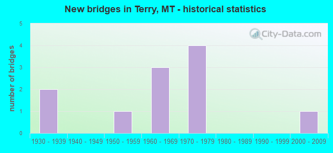
- New bridges - historical statistics
- 21930-1939
- 11950-1959
- 31960-1969
- 41970-1979
- 12000-2009

- Reconstructed bridges - Historical Statistics
- 21940-1949
- 01950-1959
- 01960-1969
- 01970-1979
- 01980-1989
- 01990-1999
- 12000-2009


- Bridge Condition - Deck
- 37.5%Good
- 37.5%Satisfactory
- 25.0%Fair

- Bridge Condition - Superstructure
- 12.5%Good
- 87.5%Satisfactory

- Bridge Condition - Substructure
- 25.0%Good
- 75.0%Satisfactory

- Bridge Condition - Channel
- 80.0%Good
- 20.0%Satisfactory
Find on map >> Show street view
Structure Number: I00094178+04401, Location: 2M E TERRY (Lat: 46.794342, Lng: -105.264428), Route carried "on" structure: Interstate 94, Year Built: 1969, Status: Open, Structure Length: 0.91m (2.99ft), Average Daily Traffic: 3,721 (year 2020), Truck Traffic: 32%, Average Future Daily Traffic: 3,907 (year 2040), Design Load: HS 20, Features Intersected: ASH CREEK
Minimum Vertical Clearance: 30+ m (98+ ft), Kilometerpoint: 286.197, Lanes on structure: 4, Base Highway Network: Yes, Owner: State Highway Agency, Approaching Roadway Width: 11.6m (38.1ft), Material/Design: Steel, Design/Construction: Culvert, Number Of Spans In Main Unit: 2, Length of Maximum Span: 3.9m (12.8ft)
Condition: Channel: Good, Culverts: Satisfactory, Structural Evaluation: Equal to present minimum criteria, Waterway Adequacy: Equal to present desirable criteria, Approach Roadway Alignment: Equal to present desirable criteria, Length Of Structure Improvement: 1.50m (4.92ft), Designated Inspection Frequency: Every 24 months, Inspection Date: March 2020, Bridge Improvement Cost: $106,000, Roadway Improvement Cost: $53,000, Total Project Cost: $159,000
Find on map >> Show street view
Structure Number: I00094179+05171, Location: 3M E TERRY (Lat: 46.795375, Lng: -105.240942), Route carried "on" structure: Interstate 94, Year Built: 1969, Status: Open, Structure Length: 15.29m (50.16ft), Average Daily Traffic: 3,721 (year 2020), Truck Traffic: 32%, Average Future Daily Traffic: 3,907 (year 2040), Design Load: HS 20, Features Intersected: RR
Minimum Vertical Clearance: 30+ m (98+ ft), Kilometerpoint: 288.000, Lanes on structure: 2, Base Highway Network: Yes, Owner: State Highway Agency, Approaching Roadway Width: 11.6m (38.1ft), Material/Design: Steel, Design/Construction: Stringer/Multi-beam, Number Of Spans In Main Unit: 2, Number Of Approach Spans: 5, Length of Maximum Span: 25.8m (84.6ft), Curb or Sidewalk Widths: Left: 0.1m (0.3ft), Right: 0.1m (0.3ft), Curb-To-Curb Width: 12.6m (41.3ft), Out-to-Out Width: 13.4m (44.0ft)
Condition: Deck: Fair, Superstructure: Satisfactory, Substructure: Good, Operating Rating: 63.5 metric tons, Method Used To Determine Operating Rating: Load Factor (LF), Inventory Rating: 34.5 metric tons, Method Used To Determine Inventory Rating: Load Factor (LF), Structural Evaluation: Equal to present minimum criteria, Deck Geometry: Better than present minimum criteria, Underclear: Better than present minimum criteria, Approach Roadway Alignment: Equal to present minimum criteria, Designated Inspection Frequency: Every 24 months, Critical Feature Inspection Frequency: Every 24 months, Other Special Inspection Frequency: Every 48 months, Inspection Date: July 2021, Critical Feature Inspection Date: July 2021, Other Special Inspection Date: August 2021, Deck Structure Type: Concrete Cast-file-Place
Find on map >> Show street view
Structure Number: I00094179+05172, Location: 3M E TERRY (Lat: 46.795517, Lng: -105.241775), Route carried "on" structure: Interstate 94, Year Built: 1969, Status: Open, Structure Length: 13.41m (44.00ft), Average Daily Traffic: 3,721 (year 2020), Truck Traffic: 32%, Average Future Daily Traffic: 3,907 (year 2040), Design Load: HS 20, Features Intersected: RR
Minimum Vertical Clearance: 30+ m (98+ ft), Kilometerpoint: 288.804, Lanes on structure: 2, Base Highway Network: Yes, Owner: State Highway Agency, Approaching Roadway Width: 11.6m (38.1ft), Material/Design: Steel, Design/Construction: Stringer/Multi-beam, Number Of Spans In Main Unit: 2, Number Of Approach Spans: 4, Length of Maximum Span: 25.8m (84.6ft), Curb or Sidewalk Widths: Left: 0.1m (0.3ft), Right: 0.1m (0.3ft), Curb-To-Curb Width: 12.6m (41.3ft), Out-to-Out Width: 13.5m (44.3ft)
Condition: Deck: Satisfactory, Superstructure: Satisfactory, Substructure: Satisfactory, Operating Rating: 66.2 metric tons, Method Used To Determine Operating Rating: Load Factor (LF), Inventory Rating: 34.5 metric tons, Method Used To Determine Inventory Rating: Load Factor (LF), Structural Evaluation: Equal to present minimum criteria, Deck Geometry: Better than present minimum criteria, Underclear: Better than present minimum criteria, Approach Roadway Alignment: Equal to present minimum criteria, Designated Inspection Frequency: Every 24 months, Critical Feature Inspection Frequency: Every 24 months, Other Special Inspection Frequency: Every 48 months, Inspection Date: July 2021, Critical Feature Inspection Date: July 2021, Other Special Inspection Date: August 2021, Deck Structure Type: Concrete Cast-file-Place
Find on map >> Show street view
Structure Number: L40004009+01001, Location: 3M SW TERRY (Lat: 46.761706, Lng: -105.381717), Route carried "on" structure: ServiceState highway 81020, Year Built: 1930, Year Reconstructed: 1948, Status: Open, Structure Length: 1.76m (5.77ft), Average Daily Traffic: 437 (year 2020), Truck Traffic: 3%, Average Future Daily Traffic: 459 (year 2040), Design Load: H 15, Features Intersected: CONN`S COULEE 021, Facility Carried by Structure: OLD HWY 10 W
Minimum Vertical Clearance: 30+ m (98+ ft), Kilometerpoint: 26.502, Lanes on structure: 2, Owner: State Highway Agency, Approaching Roadway Width: 7.7m (25.3ft), Material/Design: Wood or Timber, Design/Construction: Stringer/Multi-beam, Number Of Spans In Main Unit: 3, Length of Maximum Span: 5.8m (19.0ft), Curb-To-Curb Width: 9.4m (30.8ft), Out-to-Out Width: 9.8m (32.2ft)
Condition: Deck: Good, Superstructure: Satisfactory, Substructure: Satisfactory, Channel: Good, Operating Rating: 41.2 metric tons, Method Used To Determine Operating Rating: Allowable Stress (AS), Inventory Rating: 29.5 metric tons, Method Used To Determine Inventory Rating: Allowable Stress (AS), Structural Evaluation: Equal to present minimum criteria, Deck Geometry: Equal to present minimum criteria, Waterway Adequacy: Equal to present minimum criteria, Approach Roadway Alignment: Equal to present minimum criteria, Designated Inspection Frequency: Every 24 months, Inspection Date: October 2020, Deck Structure Type: Wood or Timber, Wearing Surface/Protective System: Wearing Surface: Bituminous
Find on map >> Show street view
Structure Number: L40004011+05001, Location: 1M SW TERRY (Lat: 46.785186, Lng: -105.338839), Route carried "on" structure: ServiceState highway 81020, Year Built: 1930, Year Reconstructed: 1948, Status: Open, Structure Length: 1.19m (3.90ft), Average Daily Traffic: 437 (year 2020), Truck Traffic: 3%, Average Future Daily Traffic: 459 (year 2040), Design Load: H 15, Features Intersected: DRAINAGE 022, Facility Carried by Structure: OLD HWY 10 W
Minimum Vertical Clearance: 30+ m (98+ ft), Kilometerpoint: 30.690, Lanes on structure: 2, Owner: State Highway Agency, Approaching Roadway Width: 7.7m (25.3ft), Material/Design: Wood or Timber, Design/Construction: Stringer/Multi-beam, Number Of Spans In Main Unit: 2, Length of Maximum Span: 5.8m (19.0ft), Curb-To-Curb Width: 9.5m (31.2ft), Out-to-Out Width: 9.8m (32.2ft)
Condition: Deck: Good, Superstructure: Satisfactory, Substructure: Satisfactory, Channel: Good, Operating Rating: 41.2 metric tons, Method Used To Determine Operating Rating: Allowable Stress (AS), Inventory Rating: 29.5 metric tons, Method Used To Determine Inventory Rating: Allowable Stress (AS), Structural Evaluation: Equal to present minimum criteria, Deck Geometry: Equal to present minimum criteria, Waterway Adequacy: Equal to present desirable criteria, Approach Roadway Alignment: Equal to present desirable criteria, Designated Inspection Frequency: Every 24 months, Inspection Date: October 2020, Deck Structure Type: Wood or Timber, Wearing Surface/Protective System: Wearing Surface: Bituminous
Find on map >> Show street view
Structure Number: L40069002+02001, Location: 2M SW TERRY (Lat: 46.768694, Lng: -105.344750), Route carried "on" structure: ServiceCounty highway 40069, Year Built: 1971, Status: Open, Structure Length: 12.32m (40.42ft), Average Daily Traffic: 100 (year 2022), Truck Traffic: 3%, Average Future Daily Traffic: 100 (year 2037), Design Load: HS 20, Features Intersected: SEP JENS I 94 002, Facility Carried by Structure: CONNS COULEE RD
Minimum Vertical Clearance: 30+ m (98+ ft), Kilometerpoint: 3.874, Lanes on structure: 2, Lanes under structure: 4, Owner: State Highway Agency, Approaching Roadway Width: 8.0m (26.2ft), Skew: 3 degrees, Material/Design: Steel, Design/Construction: Stringer/Multi-beam, Number Of Spans In Main Unit: 5, Length of Maximum Span: 32.6m (107.0ft), Curb or Sidewalk Widths: Left: 0.1m (0.3ft), Right: 0.1m (0.3ft), Curb-To-Curb Width: 9.0m (29.5ft), Out-to-Out Width: 9.8m (32.2ft)
Condition: Deck: Good, Superstructure: Satisfactory, Substructure: Satisfactory, Operating Rating: 48.1 metric tons, Method Used To Determine Operating Rating: Load and Resistance Factor (LRFR), Inventory Rating: 37.2 metric tons, Method Used To Determine Inventory Rating: Load and Resistance Factor (LRFR), Structural Evaluation: Equal to present minimum criteria, Deck Geometry: Better than present minimum criteria, Underclear: Meets minimum limits, Approach Roadway Alignment: Equal to present minimum criteria, Designated Inspection Frequency: Every 24 months, Inspection Date: July 2021, Deck Structure Type: Concrete Cast-file-Place, Wearing Surface/Protective System: Wearing Surface: Monolithic Concrete
Find on map >> Show street view
Structure Number: S00253000+00311, Location: SE TERRY (Lat: 46.787086, Lng: -105.302547), Route carried "on" structure: State highway 253, Year Built: 1971, Status: Open, Structure Length: 9.91m (32.51ft), Average Daily Traffic: 953 (year 2020), Truck Traffic: 3%, Average Future Daily Traffic: 1,001 (year 2040), Design Load: HS 20, Features Intersected: INT TERRY-I 94, Facility Carried by Structure: TEN MILE RD
Minimum Vertical Clearance: 30+ m (98+ ft), Kilometerpoint: 0.018, Lanes on structure: 2, Lanes under structure: 4, Owner: State Highway Agency, Approaching Roadway Width: 12.2m (40.0ft), Skew: 2 degrees, Material/Design: Steel, Design/Construction: Stringer/Multi-beam, Number Of Spans In Main Unit: 4, Length of Maximum Span: 32.9m (107.9ft), Curb or Sidewalk Widths: Left: 0.1m (0.3ft), Right: 0.1m (0.3ft), Curb-To-Curb Width: 13.3m (43.6ft), Out-to-Out Width: 14.1m (46.3ft)
Condition: Deck: Satisfactory, Superstructure: Satisfactory, Substructure: Good, Operating Rating: 63.5 metric tons, Method Used To Determine Operating Rating: Load Factor (LF), Inventory Rating: 38.1 metric tons, Method Used To Determine Inventory Rating: Load Factor (LF), Structural Evaluation: Equal to present minimum criteria, Deck Geometry: Superior to present desirable criteria, Underclear: Meets minimum limits, Approach Roadway Alignment: Better than present minimum criteria, Designated Inspection Frequency: Every 24 months, Inspection Date: July 2021, Deck Structure Type: Concrete Cast-file-Place, Wearing Surface/Protective System: Wearing Surface: Monolithic Concrete
Find on map >> Show street view
Structure Number: S00253001+03031, Location: 1M NE TERRY (Lat: 46.804539, Lng: -105.295822), Route carried "on" structure: State highway 253, Year Built: 1959, Year Reconstructed: 2012, Status: Open, Structure Length: 27.32m (89.63ft), Average Daily Traffic: 509 (year 2020), Truck Traffic: 5%, Average Future Daily Traffic: 534 (year 2040), Design Load: HS 15, Features Intersected: YELLOWSTONE RIVER
Minimum Vertical Clearance: 30+ m (98+ ft), Kilometerpoint: 2.177, Lanes on structure: 2, Owner: State Highway Agency, Approaching Roadway Width: 7.2m (23.6ft), Material/Design: Steel continuous, Design/Construction: Girder and Floorbeam System, Number Of Spans In Main Unit: 4, Number Of Approach Spans: 4, Length of Maximum Span: 64.0m (210.0ft), Curb-To-Curb Width: 6.8m (22.3ft), Out-to-Out Width: 8.1m (26.6ft)
Condition: Deck: Fair, Superstructure: Satisfactory, Substructure: Satisfactory, Channel: Satisfactory, Operating Rating: 20.0 metric tons, Method Used To Determine Operating Rating: Load Factor (LF), Inventory Rating: 11.8 metric tons, Method Used To Determine Inventory Rating: Load Factor (LF), Structural Evaluation: High priority of replacement, Deck Geometry: Meets minimum limits, Waterway Adequacy: Better than present minimum criteria, Approach Roadway Alignment: Equal to present desirable criteria, Length Of Structure Improvement: 25.09m (82.32ft), Designated Inspection Frequency: Every 24 months, Critical Feature Inspection Frequency: Every 24 months, Underwater Inspection Frequency: Every 60 months, Inspection Date: July 2021, Critical Feature Inspection Date: July 2021, Underwater Inspection Date: October 2020, Bridge Improvement Cost: $1,713,000, Roadway Improvement Cost: $857,000, Total Project Cost: $2,570,000, Deck Structure Type: Concrete Cast-file-Place, Wearing Surface/Protective System: Wearing Surface: Bituminous, Membrane: Preformed Fabric
Find on map >> Show street view
Structure Number: S00253005+00301, Location: 4M N TERRY (Lat: 46.850472, Lng: -105.325222), Route carried "on" structure: State highway 253, Year Built: 2007, Status: Open, Structure Length: 10.05m (32.97ft), Average Daily Traffic: 509 (year 2020), Truck Traffic: 5%, Average Future Daily Traffic: 534 (year 2040), Design Load: HS 20+Mod, Features Intersected: CHERRY CREEK
Minimum Vertical Clearance: 30+ m (98+ ft), Kilometerpoint: 8.042, Lanes on structure: 2, Owner: State Highway Agency, Approaching Roadway Width: 8.4m (27.6ft), Skew: 1 degrees, Material/Design: Prestressed concrete, Design/Construction: Stringer/Multi-beam, Number Of Spans In Main Unit: 3, Length of Maximum Span: 33.5m (109.9ft), Curb or Sidewalk Widths: Left: 0.5m (1.6ft), Right: 0.5m (1.6ft), Curb-To-Curb Width: 8.4m (27.6ft), Out-to-Out Width: 9.4m (30.8ft)
Condition: Deck: Satisfactory, Superstructure: Good, Substructure: Satisfactory, Channel: Good, Operating Rating: 66.4 metric tons, Method Used To Determine Operating Rating: Load and Resistance Factor (LRFR), Inventory Rating: 38.5 metric tons, Method Used To Determine Inventory Rating: Load and Resistance Factor (LRFR), Structural Evaluation: Equal to present minimum criteria, Deck Geometry: Somewhat better than minimum adequacy, Waterway Adequacy: Equal to present desirable criteria, Approach Roadway Alignment: Equal to present minimum criteria, Designated Inspection Frequency: Every 24 months, Inspection Date: October 2021, Deck Structure Type: Concrete Cast-file-Place, Wearing Surface/Protective System: Wearing Surface: Monolithic Concrete, Deck Protection: Epoxy Coated Reinforcing
Find on map >> Show street view
Structure Number: L40069002+02001, Location: 2M SW TERRY (Lat: 46.768694, Lng: -105.344750), Route carried "under" structure: Interstate 94, Year Built: 1971, Structure Length: 0. m, Average Daily Traffic: 4,103 (year 2020), Truck Traffic: 29%, Features Intersected: SEP JENS I 94 002, Facility Carried by Structure: CONNS COULEE RD
Minimum Vertical Clearance: 5.12m (16.80ft), Kilometerpoint: 279.295, Lanes on structure: 2, Lanes under structure: 4, Material/Design: Steel, Design/Construction: Stringer/Multi-beam, Length of Maximum Span: 32.6m (107.0ft)
Find on map >> Show street view
Structure Number: S00253000+00311, Location: SE TERRY (Lat: 46.787086, Lng: -105.302547), Route carried "under" structure: Interstate 94, Year Built: 1971, Structure Length: 0. m, Average Daily Traffic: 3,721 (year 2020), Truck Traffic: 32%, Features Intersected: INT TERRY-I 94, Facility Carried by Structure: TEN MILE RD
Minimum Vertical Clearance: 5.15m (16.90ft), Kilometerpoint: 283.114, Lanes on structure: 2, Lanes under structure: 4, Material/Design: Steel, Design/Construction: Stringer/Multi-beam, Length of Maximum Span: 32.9m (107.9ft)