Bridge Statistics for Teton, Idaho (ID)
Condition, Traffic, Stress, Structural Evaluation, Project Costs
- National Bridge Inventory (NBI) Statistics
- 14Number of bridges
- 75ft / 22.6mTotal length
- $3,228,000Total costs
- 14,980Total average daily traffic
- 1,688Total average daily truck traffic
- 22,470Total future (year 2039) average daily traffic
- National Bridge Inventory (NBI) Registered Bridges for Teton
- No street view available for this location
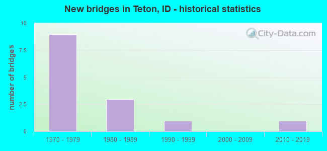
- New bridges - historical statistics
- 91970-1979
- 31980-1989
- 11990-1999
- 12010-2019


- Bridge Condition - Deck
- 7.1%Very good
- 42.9%Good
- 42.9%Satisfactory
- 7.1%Poor

- Bridge Condition - Superstructure
- 14.3%Very good
- 35.7%Good
- 42.9%Satisfactory
- 7.1%Poor

- Bridge Condition - Substructure
- 14.3%Very good
- 42.9%Good
- 14.3%Satisfactory
- 21.4%Fair
- 7.1%Poor

- Bridge Condition - Channel
- 42.9%Very good
- 35.7%Good
- 14.3%Satisfactory
- 7.1%Poor
Find on map >> Show street view
Structure Number: 1392, Location: 1.5 W. TETON (Lat: 43.883611, Lng: -111.707361), Route carried "on" structure: State highway 33, Year Built: 1976, Status: Open, Structure Length: 1.55m (5.09ft), Average Daily Traffic: 3,000 (year 2019), Truck Traffic: 7%, Average Future Daily Traffic: 4,500 (year 2039), Design Load: HS 20, Features Intersected: TETON RIVER OVERFLOW
Minimum Vertical Clearance: 30+ m (98+ ft), Kilometerpoint: 163.443, Lanes on structure: 2, Base Highway Network: Yes (Inventory Route: SH0, Subroute: 2), Owner: State Highway Agency, Approaching Roadway Width: 10.4m (34.1ft), Material/Design: Concrete, Design/Construction: Slab, Number Of Spans In Main Unit: 1, Length of Maximum Span: 15.5m (50.9ft), Curb-To-Curb Width: 11.2m (36.7ft), Out-to-Out Width: 12.1m (39.7ft)
Condition: Deck: Good, Superstructure: Good, Substructure: Very good, Channel: Good, Operating Rating: 90.6 metric tons, Method Used To Determine Operating Rating: Load Factor (LF), Inventory Rating: 57.2 metric tons, Method Used To Determine Inventory Rating: Load Factor (LF), Structural Evaluation: Better than present minimum criteria, Deck Geometry: Somewhat better than minimum adequacy, Waterway Adequacy: Equal to present desirable criteria, Approach Roadway Alignment: Equal to present desirable criteria, Designated Inspection Frequency: Every 48 months, Inspection Date: March 2020, Deck Structure Type: Concrete Cast-file-Place, Wearing Surface/Protective System: Wearing Surface: Epoxy Overlay, Deck Protection: Galvanized Reinforcing
Find on map >> Show street view
Structure Number: 13925, Location: 1.2 W. TETON (Lat: 43.883528, Lng: -111.689472), Route carried "on" structure: State highway 33, Year Built: 1975, Status: Open, Structure Length: 2.44m (8.01ft), Average Daily Traffic: 3,000 (year 2019), Truck Traffic: 7%, Average Future Daily Traffic: 4,500 (year 2039), Design Load: HS 20, Features Intersected: S.FK.TETON RIVER
Minimum Vertical Clearance: 30+ m (98+ ft), Kilometerpoint: 164.888, Lanes on structure: 2, Base Highway Network: Yes (Inventory Route: SH0, Subroute: 2), Owner: State Highway Agency, Approaching Roadway Width: 10.4m (34.1ft), Material/Design: Concrete, Design/Construction: Stringer/Multi-beam, Number Of Spans In Main Unit: 1, Length of Maximum Span: 23.8m (78.1ft), Curb-To-Curb Width: 11.2m (36.7ft), Out-to-Out Width: 12.1m (39.7ft)
Condition: Deck: Satisfactory, Superstructure: Satisfactory, Substructure: Good, Channel: Satisfactory, Operating Rating: 53.5 metric tons, Method Used To Determine Operating Rating: Load Factor (LF), Inventory Rating: 32.7 metric tons, Method Used To Determine Inventory Rating: Load Factor (LF), Structural Evaluation: Equal to present minimum criteria, Deck Geometry: Somewhat better than minimum adequacy, Waterway Adequacy: Equal to present desirable criteria, Approach Roadway Alignment: Equal to present desirable criteria, Designated Inspection Frequency: Every 24 months, Inspection Date: July 2020, Deck Structure Type: Concrete Cast-file-Place, Wearing Surface/Protective System: Wearing Surface: Monolithic Concrete
Find on map >> Show street view
Structure Number: 1393, Location: IN TETON (Lat: 43.886528, Lng: -111.665083), Route carried "on" structure: State highway 33, Year Built: 1984, Status: Open, Structure Length: 0.64m (2.10ft), Average Daily Traffic: 3,800 (year 2019), Truck Traffic: 10%, Average Future Daily Traffic: 5,700 (year 2039), Design Load: HS 20, Features Intersected: SIDDOWAY CANAL
Minimum Vertical Clearance: 30+ m (98+ ft), Kilometerpoint: 166.937, Lanes on structure: 2, Base Highway Network: Yes (Inventory Route: SH0, Subroute: 2), Owner: State Highway Agency, Approaching Roadway Width: 13.1m (43.0ft), Material/Design: Concrete, Design/Construction: Frame, Number Of Spans In Main Unit: 1, Length of Maximum Span: 6.4m (21.0ft), Curb or Sidewalk Widths: Left: 0.3m (1.0ft), Right: 0.3m (1.0ft), Curb-To-Curb Width: 16.5m (54.1ft), Out-to-Out Width: 17.1m (56.1ft)
Condition: Deck: Satisfactory, Superstructure: Satisfactory, Substructure: Satisfactory, Channel: Very good, Operating Rating: 60.8 metric tons, Method Used To Determine Operating Rating: Load Factor (LF), Inventory Rating: 36.3 metric tons, Method Used To Determine Inventory Rating: Load Factor (LF), Structural Evaluation: Equal to present minimum criteria, Deck Geometry: Superior to present desirable criteria, Waterway Adequacy: Equal to present desirable criteria, Approach Roadway Alignment: Equal to present desirable criteria, Designated Inspection Frequency: Every 48 months, Inspection Date: March 2020, Deck Structure Type: Concrete Cast-file-Place, Wearing Surface/Protective System: Wearing Surface: Bituminous, Membrane: Built-up
Find on map >> Show street view
Structure Number: 21035, Location: 0.5 N. TETON (Lat: 43.894361, Lng: -111.678056), Route carried "on" structure: County highway 6774, Year Built: 1977, Status: Posted for load, Structure Length: 4.57m (14.99ft), Average Daily Traffic: 1,000 (year 2019), Truck Traffic: 26%, Average Future Daily Traffic: 1,500 (year 2039), Design Load: HS 20, Features Intersected: S.FK.TETON RIVER
Minimum Vertical Clearance: 30+ m (98+ ft), Kilometerpoint: 11.582, Lanes on structure: 2, Owner: County Highway Agency, Approaching Roadway Width: 10.4m (34.1ft), Skew: 4 degrees, Material/Design: Prestressed concrete, Design/Construction: Box Beam or Girders - Multiple, Number Of Spans In Main Unit: 3, Length of Maximum Span: 14.6m (47.9ft), Curb-To-Curb Width: 10.7m (35.1ft), Out-to-Out Width: 11.6m (38.1ft)
Condition: Deck: Poor, Superstructure: Poor, Substructure: Poor, Channel: Poor, Operating Rating: 28.1 metric tons, Method Used To Determine Operating Rating: Load Factor (LF), Inventory Rating: 0.9 metric tons, Method Used To Determine Inventory Rating: Load Factor (LF), Structural Evaluation: High priority of replacement, Deck Geometry: Equal to present minimum criteria, Waterway Adequacy: Superior to present desirable criteria, Approach Roadway Alignment: Equal to present desirable criteria, Bridge Posting: Required (Relationship of Operating Rating to Maximum Legal Load: 0.1 - 9.9% below), Length Of Structure Improvement: 5.49m (18.01ft), Designated Inspection Frequency: Every 12 months, Inspection Date: October 2021, Bridge Improvement Cost: $1,247,000, Roadway Improvement Cost: $125,000, Total Project Cost: $1,871,000 ( Estimate for 2016), Deck Structure Type: Concrete Precast Panels, Wearing Surface/Protective System: Wearing Surface: Bituminous
Find on map >> Show street view
Structure Number: 2104, Location: 0.7 N. TETON (Lat: 43.898083, Lng: -111.678083), Route carried "on" structure: County highway 6774, Year Built: 1977, Status: Open, Structure Length: 2.65m (8.69ft), Average Daily Traffic: 1,000 (year 2019), Truck Traffic: 26%, Average Future Daily Traffic: 1,500 (year 2039), Design Load: HS 20, Features Intersected: N.FK.TETON RIVER
Minimum Vertical Clearance: 30+ m (98+ ft), Kilometerpoint: 11.977, Lanes on structure: 2, Owner: County Highway Agency, Approaching Roadway Width: 10.4m (34.1ft), Skew: 1 degrees, Material/Design: Prestressed concrete, Design/Construction: Stringer/Multi-beam, Number Of Spans In Main Unit: 1, Length of Maximum Span: 25.9m (85.0ft), Curb-To-Curb Width: 10.6m (34.8ft), Out-to-Out Width: 11.5m (37.7ft)
Condition: Deck: Good, Superstructure: Good, Substructure: Good, Channel: Very good, Operating Rating: 45.4 metric tons, Method Used To Determine Operating Rating: Load Factor (LF), Inventory Rating: 27.2 metric tons, Method Used To Determine Inventory Rating: Load Factor (LF), Structural Evaluation: Equal to present minimum criteria, Deck Geometry: Equal to present minimum criteria, Waterway Adequacy: Superior to present desirable criteria, Approach Roadway Alignment: Equal to present desirable criteria, Designated Inspection Frequency: Every 24 months, Inspection Date: October 2021, Deck Structure Type: Concrete Cast-file-Place, Wearing Surface/Protective System: Wearing Surface: Monolithic Concrete
Find on map >> Show street view
Structure Number: 3216, Location: 0.8 N. 1.0 E. TETON (Lat: 43.897250, Lng: -111.658472), Route carried "on" structure: County highway , Year Built: 1977, Status: Open, Structure Length: 0.85m (2.79ft), Average Daily Traffic: 170 (year 2019), Truck Traffic: 10%, Average Future Daily Traffic: 255 (year 2039), Design Load: HS 20, Features Intersected: TETON CANAL, Facility Carried by Structure: N 2500 E
Minimum Vertical Clearance: 30+ m (98+ ft), Kilometerpoint: 161.659, Lanes on structure: 2, Owner: County Highway Agency, Approaching Roadway Width: 7.6m (24.9ft), Skew: 1 degrees, Material/Design: Prestressed concrete, Design/Construction: Tee Beam, Number Of Spans In Main Unit: 1, Length of Maximum Span: 7.9m (25.9ft), Curb or Sidewalk Widths: Left: 0.2m (0.7ft), Right: 0.2m (0.7ft), Curb-To-Curb Width: 7.3m (24.0ft), Out-to-Out Width: 7.9m (25.9ft)
Condition: Deck: Good, Superstructure: Good, Substructure: Good, Channel: Very good, Operating Rating: 45.9 metric tons, Method Used To Determine Operating Rating: Allowable Stress (AS), Inventory Rating: 32.4 metric tons, Method Used To Determine Inventory Rating: Allowable Stress (AS), Structural Evaluation: Better than present minimum criteria, Deck Geometry: Somewhat better than minimum adequacy, Waterway Adequacy: Equal to present desirable criteria, Approach Roadway Alignment: Better than present minimum criteria, Designated Inspection Frequency: Every 24 months, Inspection Date: November 2020, Deck Structure Type: Concrete Cast-file-Place, Wearing Surface/Protective System: Wearing Surface: Bituminous
Find on map >> Show street view
Structure Number: 32165, Location: 0.9 N. 1.2 E. TETON (Lat: 43.897861, Lng: -111.655083), Route carried "on" structure: County highway , Year Built: 1980, Status: Open, Structure Length: 1.19m (3.90ft), Average Daily Traffic: 180 (year 2019), Truck Traffic: 10%, Average Future Daily Traffic: 270 (year 2039), Design Load: HS 20, Features Intersected: TETON CANAL, Facility Carried by Structure: E 100 N
Minimum Vertical Clearance: 30+ m (98+ ft), Kilometerpoint: 161.998, Lanes on structure: 2, Owner: County Highway Agency, Approaching Roadway Width: 5.8m (19.0ft), Skew: 5 degrees, Material/Design: Prestressed concrete, Design/Construction: Stringer/Multi-beam, Number Of Spans In Main Unit: 1, Length of Maximum Span: 11.3m (37.1ft), Curb or Sidewalk Widths: Left: 0.2m (0.7ft), Right: 0.2m (0.7ft), Curb-To-Curb Width: 6.9m (22.6ft), Out-to-Out Width: 7.3m (24.0ft)
Condition: Deck: Satisfactory, Superstructure: Satisfactory, Substructure: Fair, Channel: Satisfactory, Operating Rating: 48.6 metric tons, Method Used To Determine Operating Rating: Allowable Stress (AS), Inventory Rating: 29.7 metric tons, Method Used To Determine Inventory Rating: Allowable Stress (AS), Structural Evaluation: Somewhat better than minimum adequacy, Deck Geometry: Meets minimum limits, Waterway Adequacy: Equal to present desirable criteria, Approach Roadway Alignment: Equal to present desirable criteria, Length Of Structure Improvement: 1.80m (5.91ft), Designated Inspection Frequency: Every 24 months, Inspection Date: November 2020, Bridge Improvement Cost: $234,000, Roadway Improvement Cost: $23,000, Total Project Cost: $351,000 ( Estimate for 2016), Deck Structure Type: Concrete Cast-file-Place, Wearing Surface/Protective System: Wearing Surface: Bituminous
Find on map >> Show street view
Structure Number: 32203, Location: 1.5 W. WILFORD (Lat: 43.912500, Lng: -111.707500), Route carried "on" structure: County highway , Year Built: 2016, Status: Open, Structure Length: 0.82m (2.69ft), Average Daily Traffic: 950 (year 2019), Truck Traffic: 13%, Average Future Daily Traffic: 1,425 (year 2039), Design Load: HL 93, Features Intersected: FARMERS FRIEND CANAL, Facility Carried by Structure: E 200 N
Minimum Vertical Clearance: 30+ m (98+ ft), Kilometerpoint: 169.773, Lanes on structure: 2, Owner: County Highway Agency, Approaching Roadway Width: 6.7m (22.0ft), Material/Design: Concrete, Design/Construction: Frame, Number Of Spans In Main Unit: 1, Length of Maximum Span: 4.0m (13.1ft), Curb-To-Curb Width: 10.7m (35.1ft), Out-to-Out Width: 11.0m (36.1ft)
Condition: Deck: Very good, Superstructure: Very good, Substructure: Very good, Channel: Very good, Operating Rating: 80.4 metric tons, Method Used To Determine Operating Rating: Load and Resistance Factor Rating (LRFR) rating reported by rating factor(RF) method using HL-93 loadings, Inventory Rating: 61.9 metric tons, Method Used To Determine Inventory Rating: Load and Resistance Factor Rating (LRFR) rating reported by rating factor(RF) method using HL-93 loadings, Structural Evaluation: Equal to present desirable criteria, Deck Geometry: Equal to present minimum criteria, Waterway Adequacy: Equal to present desirable criteria, Approach Roadway Alignment: Equal to present desirable criteria, Designated Inspection Frequency: Every 48 months, Inspection Date: April 2018, Deck Structure Type: Concrete Cast-file-Place, Wearing Surface/Protective System: Deck Protection: Epoxy Coated Reinforcing
Find on map >> Show street view
Structure Number: 32205, Location: 3.3 S. 2.2 E. ST ANTHONY (Lat: 43.912556, Lng: -111.638417), Route carried "on" structure: County highway , Year Built: 1977, Status: Open, Structure Length: 0.70m (2.30ft), Average Daily Traffic: 950 (year 2019), Truck Traffic: 13%, Average Future Daily Traffic: 1,425 (year 2039), Design Load: HS 20, Features Intersected: WILFORD CANAL, Facility Carried by Structure: N 2600 E
Minimum Vertical Clearance: 30+ m (98+ ft), Kilometerpoint: 175.390, Lanes on structure: 2, Owner: County Highway Agency, Approaching Roadway Width: 8.5m (27.9ft), Material/Design: Prestressed concrete, Design/Construction: Box Beam or Girders - Multiple, Number Of Spans In Main Unit: 1, Length of Maximum Span: 6.4m (21.0ft), Curb or Sidewalk Widths: Left: 0.2m (0.7ft), Right: 0.2m (0.7ft), Curb-To-Curb Width: 7.9m (25.9ft), Out-to-Out Width: 8.5m (27.9ft)
Condition: Deck: Satisfactory, Superstructure: Satisfactory, Substructure: Good, Channel: Good, Operating Rating: 60.8 metric tons, Method Used To Determine Operating Rating: Allowable Stress (AS), Inventory Rating: 37.8 metric tons, Method Used To Determine Inventory Rating: Allowable Stress (AS), Structural Evaluation: Equal to present minimum criteria, Deck Geometry: Somewhat better than minimum adequacy, Waterway Adequacy: Equal to present desirable criteria, Approach Roadway Alignment: Somewhat better than minimum adequacy, Designated Inspection Frequency: Every 48 months, Inspection Date: October 2021, Deck Structure Type: Concrete Precast Panels, Wearing Surface/Protective System: Wearing Surface: Bituminous
Find on map >> Show street view
Structure Number: 32208, Location: 1.0 W. WILFORD (Lat: 43.912306, Lng: -111.697944), Route carried "on" structure: County highway , Year Built: 1997, Status: Open, Structure Length: 0.85m (2.79ft), Average Daily Traffic: 140 (year 2019), Truck Traffic: 10%, Average Future Daily Traffic: 210 (year 2039), Design Load: HS 20, Features Intersected: S. BRANCH WILFORD CANAL, Facility Carried by Structure: N 2300 E
Minimum Vertical Clearance: 30+ m (98+ ft), Kilometerpoint: 164.142, Lanes on structure: 2, Owner: County Highway Agency, Approaching Roadway Width: 7.6m (24.9ft), Material/Design: Prestressed concrete, Design/Construction: Tee Beam, Number Of Spans In Main Unit: 1, Length of Maximum Span: 7.9m (25.9ft), Curb or Sidewalk Widths: Left: 0.3m (1.0ft), Right: 0.3m (1.0ft), Curb-To-Curb Width: 9.2m (30.2ft), Out-to-Out Width: 9.8m (32.2ft)
Condition: Deck: Good, Superstructure: Good, Substructure: Good, Channel: Very good, Operating Rating: 48.1 metric tons, Method Used To Determine Operating Rating: Load Factor (LF), Inventory Rating: 29.0 metric tons, Method Used To Determine Inventory Rating: Load Factor (LF), Structural Evaluation: Better than present minimum criteria, Deck Geometry: Equal to present minimum criteria, Waterway Adequacy: Equal to present desirable criteria, Approach Roadway Alignment: Equal to present desirable criteria, Designated Inspection Frequency: Every 24 months, Inspection Date: April 2020, Deck Structure Type: Concrete Cast-file-Place, Wearing Surface/Protective System: Wearing Surface: Bituminous
Find on map >> Show street view
Structure Number: 3282, Location: 0.3 N. 1.0 W. TETON (Lat: 43.890917, Lng: -111.698056), Route carried "on" structure: County highway , Year Built: 1977, Status: Open, Structure Length: 1.43m (4.69ft), Average Daily Traffic: 110 (year 2019), Truck Traffic: 10%, Average Future Daily Traffic: 165 (year 2039), Design Load: HS 20, Features Intersected: TETON ISLAND CANAL, Facility Carried by Structure: N 2300 E; CRANE LN
Minimum Vertical Clearance: 30+ m (98+ ft), Kilometerpoint: 161.766, Lanes on structure: 2, Owner: County Highway Agency, Approaching Roadway Width: 7.3m (24.0ft), Skew: 2 degrees, Material/Design: Prestressed concrete, Design/Construction: Tee Beam, Number Of Spans In Main Unit: 1, Length of Maximum Span: 13.7m (44.9ft), Curb or Sidewalk Widths: Left: 0.2m (0.7ft), Right: 0.2m (0.7ft), Curb-To-Curb Width: 8.0m (26.2ft), Out-to-Out Width: 8.6m (28.2ft)
Condition: Deck: Satisfactory, Superstructure: Satisfactory, Substructure: Fair, Channel: Very good, Operating Rating: 27.2 metric tons, Method Used To Determine Operating Rating: Field evaluation and documented engineering judgment, Inventory Rating: 16.3 metric tons, Method Used To Determine Inventory Rating: Field evaluation and documented engineering judgment, Structural Evaluation: Somewhat better than minimum adequacy, Deck Geometry: Somewhat better than minimum adequacy, Waterway Adequacy: Equal to present desirable criteria, Approach Roadway Alignment: Equal to present desirable criteria, Length Of Structure Improvement: 2.13m (6.99ft), Designated Inspection Frequency: Every 24 months, Inspection Date: April 2021, Bridge Improvement Cost: $323,000, Roadway Improvement Cost: $32,000, Total Project Cost: $485,000 ( Estimate for 2021), Deck Structure Type: Concrete Cast-file-Place, Wearing Surface/Protective System: Wearing Surface: Bituminous
Find on map >> Show street view
Structure Number: 32835, Location: 0.5 N. 1.0 W. TETON (Lat: 43.894167, Lng: -111.698083), Route carried "on" structure: County highway , Year Built: 1977, Status: Open, Structure Length: 1.58m (5.18ft), Average Daily Traffic: 70 (year 2019), Truck Traffic: 10%, Average Future Daily Traffic: 105 (year 2039), Design Load: HS 20, Features Intersected: N.FK.TETON R;NW.TETON BR, Facility Carried by Structure: CRANE RD(N 2300E)
Minimum Vertical Clearance: 30+ m (98+ ft), Kilometerpoint: 162.130, Lanes on structure: 2, Owner: County Highway Agency, Approaching Roadway Width: 7.3m (24.0ft), Material/Design: Prestressed concrete, Design/Construction: Tee Beam, Number Of Spans In Main Unit: 1, Length of Maximum Span: 15.5m (50.9ft), Curb or Sidewalk Widths: Left: 0.2m (0.7ft), Right: 0.2m (0.7ft), Curb-To-Curb Width: 8.0m (26.2ft), Out-to-Out Width: 8.6m (28.2ft)
Condition: Deck: Satisfactory, Superstructure: Satisfactory, Substructure: Fair, Channel: Good, Operating Rating: 27.2 metric tons, Method Used To Determine Operating Rating: Field evaluation and documented engineering judgment, Inventory Rating: 16.3 metric tons, Method Used To Determine Inventory Rating: Field evaluation and documented engineering judgment, Structural Evaluation: Somewhat better than minimum adequacy, Deck Geometry: Equal to present minimum criteria, Waterway Adequacy: Superior to present desirable criteria, Approach Roadway Alignment: Equal to present desirable criteria, Length Of Structure Improvement: 2.29m (7.51ft), Designated Inspection Frequency: Every 24 months, Inspection Date: October 2020, Bridge Improvement Cost: $347,000, Roadway Improvement Cost: $35,000, Total Project Cost: $521,000 ( Estimate for 2020), Deck Structure Type: Concrete Cast-file-Place, Wearing Surface/Protective System: Wearing Surface: Bituminous
Find on map >> Show street view
Structure Number: 32845, Location: 2.1 N. 4.6 E. REXBURG (Lat: 43.854722, Lng: -111.698056), Route carried "on" structure: County highway , Year Built: 1977, Status: Open, Structure Length: 0.64m (2.10ft), Average Daily Traffic: 540 (year 2019), Truck Traffic: 9%, Average Future Daily Traffic: 810 (year 2039), Design Load: HS 20, Features Intersected: MOODY CREEK, Facility Carried by Structure: N 4000 E
Minimum Vertical Clearance: 30+ m (98+ ft), Kilometerpoint: 160.946, Lanes on structure: 2, Owner: County Highway Agency, Approaching Roadway Width: 8.5m (27.9ft), Material/Design: Concrete, Design/Construction: Frame, Number Of Spans In Main Unit: 1, Length of Maximum Span: 6.4m (21.0ft), Curb or Sidewalk Widths: Left: 0.3m (1.0ft), Right: 0.3m (1.0ft), Curb-To-Curb Width: 8.5m (27.9ft), Out-to-Out Width: 9.1m (29.9ft)
Condition: Deck: Good, Superstructure: Good, Substructure: Satisfactory, Channel: Good, Operating Rating: 47.2 metric tons, Method Used To Determine Operating Rating: Field evaluation and documented engineering judgment, Inventory Rating: 28.1 metric tons, Method Used To Determine Inventory Rating: Field evaluation and documented engineering judgment, Structural Evaluation: Equal to present minimum criteria, Deck Geometry: Somewhat better than minimum adequacy, Waterway Adequacy: Better than present minimum criteria, Approach Roadway Alignment: Equal to present minimum criteria, Designated Inspection Frequency: Every 24 months, Inspection Date: April 2021, Deck Structure Type: Concrete Cast-file-Place, Wearing Surface/Protective System: Wearing Surface: Bituminous
Find on map >> Show street view
Structure Number: 329, Location: 0.2 S. 2.2 E. SUGAR CITY (Lat: 43.869139, Lng: -111.702139), Route carried "on" structure: County highway , Year Built: 1988, Status: Open, Structure Length: 2.74m (8.99ft), Average Daily Traffic: 70 (year 2019), Truck Traffic: 10%, Average Future Daily Traffic: 105 (year 2039), Design Load: HS 20, Features Intersected: S.FK.TETON RIVER, Facility Carried by Structure: E 3000 N
Minimum Vertical Clearance: 30+ m (98+ ft), Kilometerpoint: 176.962, Lanes on structure: 2, Owner: County Highway Agency, Approaching Roadway Width: 8.5m (27.9ft), Material/Design: Concrete, Design/Construction: Stringer/Multi-beam, Number Of Spans In Main Unit: 1, Length of Maximum Span: 26.8m (87.9ft), Curb-To-Curb Width: 9.4m (30.8ft), Out-to-Out Width: 10.3m (33.8ft)
Condition: Deck: Good, Superstructure: Very good, Substructure: Good, Channel: Good, Operating Rating: 59.9 metric tons, Method Used To Determine Operating Rating: Allowable Stress (AS), Inventory Rating: 42.3 metric tons, Method Used To Determine Inventory Rating: Allowable Stress (AS), Structural Evaluation: Better than present minimum criteria, Deck Geometry: Better than present minimum criteria, Waterway Adequacy: Superior to present desirable criteria, Approach Roadway Alignment: Equal to present desirable criteria, Designated Inspection Frequency: Every 24 months, Inspection Date: April 2020, Deck Structure Type: Concrete Cast-file-Place, Wearing Surface/Protective System: Wearing Surface: Bituminous