Bridge Statistics for Three Forks, Montana (MT)
Condition, Traffic, Stress, Structural Evaluation, Project Costs
- National Bridge Inventory (NBI) Statistics
- 14Number of bridges
- 387ft / 118mTotal length
- $4,847,000Total costs
- 136,545Total average daily traffic
- 20,244Total average daily truck traffic
- National Bridge Inventory (NBI) Registered Bridges for Three Forks
- No street view available for this location
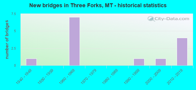
- New bridges - historical statistics
- 11940-1949
- 71960-1969
- 11990-1999
- 12000-2009
- 42010-2019


- Bridge Condition - Deck
- 16.7%Good
- 58.3%Satisfactory
- 25.0%Fair

- Bridge Condition - Superstructure
- 66.7%Good
- 33.3%Satisfactory

- Bridge Condition - Substructure
- 16.7%Good
- 58.3%Satisfactory
- 25.0%Fair

- Bridge Condition - Channel
- 62.5%Very good
- 37.5%Satisfactory
Find on map >> Show street view
Structure Number: I00090277+08261, Location: THREE FORKS (Lat: 45.905311, Lng: -111.543397), Route carried "on" structure: Interstate 90, Year Built: 1969, Status: Open, Structure Length: 7.77m (25.49ft), Average Daily Traffic: 12,122 (year 2020), Truck Traffic: 18%, Average Future Daily Traffic: 13,274 (year 2040), Design Load: HS 20, Features Intersected: JEFFERSON RIVER OVERFLOW
Minimum Vertical Clearance: 30+ m (98+ ft), Kilometerpoint: 444.171, Lanes on structure: 2, Base Highway Network: Yes, Owner: State Highway Agency, Approaching Roadway Width: 11.6m (38.1ft), Material/Design: Prestressed concrete, Design/Construction: Stringer/Multi-beam, Number Of Spans In Main Unit: 4, Length of Maximum Span: 21.3m (69.9ft), Curb-To-Curb Width: 11.6m (38.1ft), Out-to-Out Width: 12.5m (41.0ft)
Condition: Deck: Satisfactory, Superstructure: Good, Substructure: Satisfactory, Channel: Very good, Operating Rating: 40.8 metric tons, Method Used To Determine Operating Rating: Load and Resistance Factor (LRFR), Inventory Rating: 17.2 metric tons, Method Used To Determine Inventory Rating: Load and Resistance Factor (LRFR), Structural Evaluation: Meets minimum limits, Deck Geometry: Equal to present minimum criteria, Waterway Adequacy: Equal to present desirable criteria, Approach Roadway Alignment: Equal to present desirable criteria, Designated Inspection Frequency: Every 24 months, Inspection Date: July 2020, Deck Structure Type: Concrete Cast-file-Place
Find on map >> Show street view
Structure Number: I00090277+09261, Location: THREE FORKS (Lat: 45.904297, Lng: -111.541933), Route carried "on" structure: Interstate 90, Year Built: 1969, Status: Open, Structure Length: 6.04m (19.82ft), Average Daily Traffic: 12,122 (year 2020), Truck Traffic: 18%, Average Future Daily Traffic: 13,274 (year 2040), Design Load: HS 20, Features Intersected: ABANDONED RR
Minimum Vertical Clearance: 30+ m (98+ ft), Kilometerpoint: 444.332, Lanes on structure: 2, Base Highway Network: Yes, Owner: State Highway Agency, Approaching Roadway Width: 11.6m (38.1ft), Material/Design: Prestressed concrete, Design/Construction: Stringer/Multi-beam, Number Of Spans In Main Unit: 3, Length of Maximum Span: 22.9m (75.1ft), Curb-To-Curb Width: 11.6m (38.1ft), Out-to-Out Width: 12.5m (41.0ft)
Condition: Deck: Good, Superstructure: Satisfactory, Substructure: Fair, Operating Rating: 48.1 metric tons, Method Used To Determine Operating Rating: Load and Resistance Factor (LRFR), Inventory Rating: 37.2 metric tons, Method Used To Determine Inventory Rating: Load and Resistance Factor (LRFR), Structural Evaluation: Somewhat better than minimum adequacy, Deck Geometry: Equal to present minimum criteria, Approach Roadway Alignment: Equal to present desirable criteria, Designated Inspection Frequency: Every 24 months, Other Special Inspection Frequency: Every 6 months, Inspection Date: January 2022, Other Special Inspection Date: January 2022, Deck Structure Type: Concrete Cast-file-Place
Find on map >> Show street view
Structure Number: I00090277+09262, Location: THREE FORKS (Lat: 45.904489, Lng: -111.541678), Route carried "on" structure: Interstate 90, Year Built: 1969, Status: Open, Structure Length: 6.19m (20.31ft), Average Daily Traffic: 12,122 (year 2020), Truck Traffic: 18%, Average Future Daily Traffic: 13,274 (year 2040), Design Load: HS 20, Features Intersected: ABANDONED RR
Minimum Vertical Clearance: 30+ m (98+ ft), Kilometerpoint: 444.528, Lanes on structure: 2, Base Highway Network: Yes, Owner: State Highway Agency, Approaching Roadway Width: 11.6m (38.1ft), Material/Design: Prestressed concrete, Design/Construction: Stringer/Multi-beam, Number Of Spans In Main Unit: 3, Length of Maximum Span: 22.9m (75.1ft), Curb-To-Curb Width: 11.6m (38.1ft), Out-to-Out Width: 12.5m (41.0ft)
Condition: Deck: Good, Superstructure: Good, Substructure: Fair, Operating Rating: 48.1 metric tons, Method Used To Determine Operating Rating: Load and Resistance Factor (LRFR), Inventory Rating: 37.2 metric tons, Method Used To Determine Inventory Rating: Load and Resistance Factor (LRFR), Structural Evaluation: Somewhat better than minimum adequacy, Deck Geometry: Equal to present minimum criteria, Approach Roadway Alignment: Equal to present desirable criteria, Designated Inspection Frequency: Every 24 months, Other Special Inspection Frequency: Every 6 months, Inspection Date: January 2022, Other Special Inspection Date: January 2022, Deck Structure Type: Concrete Cast-file-Place
Find on map >> Show street view
Structure Number: I00090278+08571, Location: 0.6M E THREE FORKS (Lat: 45.898756, Lng: -111.524467), Route carried "on" structure: Interstate 90, Year Built: 1964, Status: Open, Structure Length: 22.43m (73.59ft), Average Daily Traffic: 16,119 (year 2020), Truck Traffic: 14%, Average Future Daily Traffic: 17,650 (year 2040), Design Load: HS 20, Features Intersected: MADISON RIVER-RR
Minimum Vertical Clearance: 30+ m (98+ ft), Kilometerpoint: 445.826, Lanes on structure: 2, Base Highway Network: Yes, Owner: State Highway Agency, Approaching Roadway Width: 11.6m (38.1ft), Material/Design: Prestressed concrete, Design/Construction: Stringer/Multi-beam, Number Of Spans In Main Unit: 11, Length of Maximum Span: 21.3m (69.9ft), Curb-To-Curb Width: 8.5m (27.9ft), Out-to-Out Width: 9.6m (31.5ft)
Condition: Deck: Satisfactory, Superstructure: Good, Substructure: Fair, Channel: Satisfactory, Operating Rating: 41.7 metric tons, Method Used To Determine Operating Rating: Load and Resistance Factor (LRFR), Inventory Rating: 30.8 metric tons, Method Used To Determine Inventory Rating: Load and Resistance Factor (LRFR), Structural Evaluation: Somewhat better than minimum adequacy, Deck Geometry: High priority of corrective action, Underclear: Equal to present minimum criteria, Waterway Adequacy: Equal to present desirable criteria, Approach Roadway Alignment: Equal to present desirable criteria, Length Of Structure Improvement: 22.49m (73.79ft), Designated Inspection Frequency: Every 24 months, Underwater Inspection Frequency: Every 60 months, Inspection Date: January 2021, Underwater Inspection Date: August 2020, Bridge Improvement Cost: $1,382,000, Roadway Improvement Cost: $691,000, Total Project Cost: $2,073,000, Deck Structure Type: Concrete Cast-file-Place, Wearing Surface/Protective System: Wearing Surface: Epoxy Overlay
Find on map >> Show street view
Structure Number: I00090278+08572, Location: 0.6M E THREE FORKS (Lat: 45.898925, Lng: -111.524322), Route carried "on" structure: Interstate 90, Year Built: 1964, Status: Open, Structure Length: 19.04m (62.47ft), Average Daily Traffic: 16,119 (year 2020), Truck Traffic: 14%, Average Future Daily Traffic: 17,650 (year 2040), Design Load: HS 20, Features Intersected: MADISON RIVER-RR
Minimum Vertical Clearance: 30+ m (98+ ft), Kilometerpoint: 446.016, Lanes on structure: 2, Base Highway Network: Yes, Owner: State Highway Agency, Approaching Roadway Width: 11.6m (38.1ft), Material/Design: Prestressed concrete, Design/Construction: Stringer/Multi-beam, Number Of Spans In Main Unit: 10, Length of Maximum Span: 21.3m (69.9ft), Curb-To-Curb Width: 8.5m (27.9ft), Out-to-Out Width: 9.6m (31.5ft)
Condition: Deck: Satisfactory, Superstructure: Good, Substructure: Satisfactory, Channel: Satisfactory, Operating Rating: 45.4 metric tons, Method Used To Determine Operating Rating: Load and Resistance Factor (LRFR), Inventory Rating: 23.6 metric tons, Method Used To Determine Inventory Rating: Load and Resistance Factor (LRFR), Structural Evaluation: Somewhat better than minimum adequacy, Deck Geometry: High priority of corrective action, Underclear: Better than present minimum criteria, Waterway Adequacy: Equal to present desirable criteria, Approach Roadway Alignment: Better than present minimum criteria, Length Of Structure Improvement: 19.70m (64.63ft), Designated Inspection Frequency: Every 24 months, Underwater Inspection Frequency: Every 60 months, Inspection Date: January 2021, Underwater Inspection Date: August 2020, Bridge Improvement Cost: $1,041,000, Roadway Improvement Cost: $521,000, Total Project Cost: $1,562,000, Deck Structure Type: Concrete Cast-file-Place, Wearing Surface/Protective System: Wearing Surface: Epoxy Overlay
Find on map >> Show street view
Structure Number: I00090279+05341, Location: 1.9M E THREE FORKS (Lat: 45.897542, Lng: -111.510414), Route carried "on" structure: Interstate 90, Year Built: 1963, Status: Open, Structure Length: 4.39m (14.40ft), Average Daily Traffic: 16,119 (year 2020), Truck Traffic: 14%, Average Future Daily Traffic: 17,650 (year 2040), Design Load: HS 20, Features Intersected: DARLINGTON DITCH
Minimum Vertical Clearance: 30+ m (98+ ft), Kilometerpoint: 446.932, Lanes on structure: 2, Base Highway Network: Yes, Owner: State Highway Agency, Approaching Roadway Width: 11.6m (38.1ft), Skew: 2 degrees, Material/Design: Prestressed concrete, Design/Construction: Stringer/Multi-beam, Number Of Spans In Main Unit: 3, Length of Maximum Span: 15.7m (51.5ft), Curb-To-Curb Width: 11.6m (38.1ft), Out-to-Out Width: 12.6m (41.3ft)
Condition: Deck: Fair, Superstructure: Good, Substructure: Satisfactory, Channel: Very good, Operating Rating: 41.7 metric tons, Method Used To Determine Operating Rating: Load and Resistance Factor (LRFR), Inventory Rating: 32.7 metric tons, Method Used To Determine Inventory Rating: Load and Resistance Factor (LRFR), Structural Evaluation: Equal to present minimum criteria, Deck Geometry: Equal to present minimum criteria, Waterway Adequacy: Equal to present desirable criteria, Approach Roadway Alignment: Equal to present desirable criteria, Designated Inspection Frequency: Every 24 months, Inspection Date: March 2020, Deck Structure Type: Concrete Cast-file-Place, Wearing Surface/Protective System: Wearing Surface: Latex Concrete, Deck Protection: Bituminous
Find on map >> Show street view
Structure Number: I00090279+05342, Location: 1.9M E THREE FORKS (Lat: 45.897767, Lng: -111.510489), Route carried "on" structure: Interstate 90, Year Built: 1963, Status: Open, Structure Length: 4.39m (14.40ft), Average Daily Traffic: 16,119 (year 2020), Truck Traffic: 14%, Average Future Daily Traffic: 17,650 (year 2040), Design Load: HS 20, Features Intersected: DARLINGTON DITCH
Minimum Vertical Clearance: 30+ m (98+ ft), Kilometerpoint: 447.100, Lanes on structure: 2, Base Highway Network: Yes, Owner: State Highway Agency, Approaching Roadway Width: 11.6m (38.1ft), Skew: 2 degrees, Material/Design: Prestressed concrete, Design/Construction: Stringer/Multi-beam, Number Of Spans In Main Unit: 3, Length of Maximum Span: 15.7m (51.5ft), Curb-To-Curb Width: 11.6m (38.1ft), Out-to-Out Width: 12.6m (41.3ft)
Condition: Deck: Fair, Superstructure: Good, Substructure: Satisfactory, Channel: Very good, Operating Rating: 41.7 metric tons, Method Used To Determine Operating Rating: Load and Resistance Factor (LRFR), Inventory Rating: 32.7 metric tons, Method Used To Determine Inventory Rating: Load and Resistance Factor (LRFR), Structural Evaluation: Equal to present minimum criteria, Deck Geometry: Equal to present minimum criteria, Waterway Adequacy: Equal to present desirable criteria, Approach Roadway Alignment: Equal to present desirable criteria, Designated Inspection Frequency: Every 24 months, Inspection Date: March 2020, Deck Structure Type: Concrete Cast-file-Place, Wearing Surface/Protective System: Wearing Surface: Latex Concrete, Deck Protection: Bituminous
Find on map >> Show street view
Structure Number: P00008006+02301, Location: 5M E GARRISON (Lat: 46.548519, Lng: -112.678178), Route carried "on" structure: US 12, Year Built: 2009, Status: Open, Structure Length: 22.71m (74.51ft), Average Daily Traffic: 2,953 (year 2020), Truck Traffic: 9%, Average Future Daily Traffic: 3,130 (year 2040), Design Load: HL 93, Features Intersected: LITTLE BLACKFOOT RIV-RR
Minimum Vertical Clearance: 30+ m (98+ ft), Kilometerpoint: 9.882, Lanes on structure: 2, Lanes under structure: 2, Base Highway Network: Yes, Owner: State Highway Agency, Approaching Roadway Width: 12.6m (41.3ft), Material/Design: Prestressed concrete, Design/Construction: Stringer/Multi-beam, Number Of Spans In Main Unit: 6, Length of Maximum Span: 40.0m (131.2ft), Curb-To-Curb Width: 11.8m (38.7ft), Out-to-Out Width: 12.6m (41.3ft)
Condition: Deck: Satisfactory, Superstructure: Good, Substructure: Good, Channel: Very good, Operating Rating: 68.9 metric tons, Method Used To Determine Operating Rating: Load and Resistance Factor (LRFR), Inventory Rating: 41.7 metric tons, Method Used To Determine Inventory Rating: Load and Resistance Factor (LRFR), Structural Evaluation: Better than present minimum criteria, Deck Geometry: Somewhat better than minimum adequacy, Underclear: Somewhat better than minimum adequacy, Waterway Adequacy: Equal to present desirable criteria, Approach Roadway Alignment: Equal to present minimum criteria, Length Of Structure Improvement: 14.90m (48.88ft), Designated Inspection Frequency: Every 24 months, Inspection Date: December 2020, Bridge Improvement Cost: $808,000, Roadway Improvement Cost: $404,000, Total Project Cost: $1,212,000, Deck Structure Type: Concrete Cast-file-Place, Wearing Surface/Protective System: Deck Protection: Epoxy Coated Reinforcing
Find on map >> Show street view
Structure Number: P00008107+08931, Location: 3M W THREE FORKS (Lat: 45.918422, Lng: -111.597361), Route carried "on" structure: US 287, Year Built: 2012, Status: Open, Structure Length: 8.40m (27.56ft), Average Daily Traffic: 6,014 (year 2020), Truck Traffic: 5%, Average Future Daily Traffic: 7,066 (year 2040), Design Load: HL 93, Features Intersected: INT THREE FORKS I 90
Minimum Vertical Clearance: 30+ m (98+ ft), Kilometerpoint: 173.519, Lanes on structure: 2, Lanes under structure: 4, Base Highway Network: Yes, Owner: State Highway Agency, Approaching Roadway Width: 16.8m (55.1ft), Material/Design: Steel continuous, Design/Construction: Stringer/Multi-beam, Number Of Spans In Main Unit: 2, Length of Maximum Span: 42.0m (137.8ft), Curb-To-Curb Width: 16.8m (55.1ft), Out-to-Out Width: 16.8m (55.1ft)
Condition: Deck: Fair, Superstructure: Satisfactory, Substructure: Satisfactory, Operating Rating: 50.4 metric tons, Method Used To Determine Operating Rating: Load and Resistance Factor (LRFR), Inventory Rating: 38.9 metric tons, Method Used To Determine Inventory Rating: Load and Resistance Factor (LRFR), Structural Evaluation: Equal to present minimum criteria, Deck Geometry: Superior to present desirable criteria, Underclear: Better than present minimum criteria, Approach Roadway Alignment: Equal to present desirable criteria, Designated Inspection Frequency: Every 24 months, Inspection Date: August 2020, Deck Structure Type: Concrete Cast-file-Place, Wearing Surface/Protective System: Deck Protection: Epoxy Coated Reinforcing
Find on map >> Show street view
Structure Number: P00013097+03301, Location: THREE FORKS (Lat: 45.901642, Lng: -111.534361), Route carried "on" structure: State highway 2, Year Built: 2010, Status: Open, Structure Length: 6.94m (22.77ft), Average Daily Traffic: 100 (year 2022), Truck Traffic: 3%, Average Future Daily Traffic: 100 (year 2037), Design Load: HL 93, Features Intersected: E THREE FORKS INT I 90
Minimum Vertical Clearance: 30+ m (98+ ft), Kilometerpoint: 157.210, Lanes on structure: 2, Lanes under structure: 4, Base Highway Network: Yes, Owner: State Highway Agency, Approaching Roadway Width: 12.6m (41.3ft), Skew: 2 degrees, Material/Design: Prestressed concrete, Design/Construction: Stringer/Multi-beam, Number Of Spans In Main Unit: 4, Length of Maximum Span: 20.7m (67.9ft), Curb or Sidewalk Widths: Left: 0.4m (1.3ft), Right: 0.4m (1.3ft), Curb-To-Curb Width: 11.8m (38.7ft), Out-to-Out Width: 12.6m (41.3ft)
Condition: Deck: Satisfactory, Superstructure: Good, Substructure: Satisfactory, Operating Rating: 49.0 metric tons, Method Used To Determine Operating Rating: Load and Resistance Factor (LRFR), Inventory Rating: 29.0 metric tons, Method Used To Determine Inventory Rating: Load and Resistance Factor (LRFR), Structural Evaluation: Equal to present minimum criteria, Deck Geometry: Superior to present desirable criteria, Underclear: Meets minimum limits, Approach Roadway Alignment: Equal to present minimum criteria, Designated Inspection Frequency: Every 24 months, Inspection Date: January 2021, Deck Structure Type: Concrete Cast-file-Place, Wearing Surface/Protective System: Deck Protection: Epoxy Coated Reinforcing
Find on map >> Show street view
Structure Number: S00205000+04911, Location: 1M E THREE FORKS (Lat: 45.901053, Lng: -111.525617), Route carried "on" structure: State highway 205, Year Built: 1948, Year Reconstructed: 2004, Status: Open, Structure Length: 6.82m (22.38ft), Average Daily Traffic: 1,046 (year 2020), Average Future Daily Traffic: 1,098 (year 2040), Design Load: HS 20, Features Intersected: MADISON RIVER
Minimum Vertical Clearance: 30+ m (98+ ft), Kilometerpoint: 0.795, Lanes on structure: 2, Owner: State Highway Agency, Approaching Roadway Width: 9.1m (29.9ft), Skew: 1 degrees, Material/Design: Steel continuous, Design/Construction: Stringer/Multi-beam, Number Of Spans In Main Unit: 2, Length of Maximum Span: 33.5m (109.9ft), Curb-To-Curb Width: 8.6m (28.2ft), Out-to-Out Width: 9.8m (32.2ft)
Condition: Deck: Satisfactory, Superstructure: Satisfactory, Substructure: Satisfactory, Channel: Satisfactory, Operating Rating: 66.2 metric tons, Method Used To Determine Operating Rating: Load Factor (LF), Inventory Rating: 39.9 metric tons, Method Used To Determine Inventory Rating: Load Factor (LF), Structural Evaluation: Equal to present minimum criteria, Deck Geometry: Somewhat better than minimum adequacy, Waterway Adequacy: Equal to present desirable criteria, Approach Roadway Alignment: Equal to present desirable criteria, Designated Inspection Frequency: Every 24 months, Underwater Inspection Frequency: Every 60 months, Inspection Date: May 2021, Underwater Inspection Date: September 2019, Deck Structure Type: Concrete Cast-file-Place
Find on map >> Show street view
Structure Number: S00205001+02381, Location: 2M E THREE FORKS (Lat: 45.899875, Lng: -111.512603), Route carried "on" structure: State highway 205, Year Built: 1990, Status: Open, Structure Length: 2.94m (9.65ft), Average Daily Traffic: 1,046 (year 2020), Average Future Daily Traffic: 1,098 (year 2040), Design Load: HS 20, Features Intersected: MID FORK MADISON RIVER
Minimum Vertical Clearance: 30+ m (98+ ft), Kilometerpoint: 1.821, Lanes on structure: 2, Owner: State Highway Agency, Approaching Roadway Width: 9.1m (29.9ft), Skew: 1 degrees, Material/Design: Concrete continuous, Design/Construction: Slab, Number Of Spans In Main Unit: 5, Length of Maximum Span: 8.4m (27.6ft), Curb-To-Curb Width: 10.4m (34.1ft), Out-to-Out Width: 11.1m (36.4ft)
Condition: Deck: Satisfactory, Superstructure: Satisfactory, Substructure: Good, Channel: Very good, Operating Rating: 54.4 metric tons, Method Used To Determine Operating Rating: Load and Resistance Factor (LRFR), Inventory Rating: 41.7 metric tons, Method Used To Determine Inventory Rating: Load and Resistance Factor (LRFR), Structural Evaluation: Equal to present minimum criteria, Deck Geometry: Equal to present minimum criteria, Waterway Adequacy: Equal to present desirable criteria, Approach Roadway Alignment: Equal to present desirable criteria, Designated Inspection Frequency: Every 24 months, Inspection Date: April 2020, Deck Structure Type: Concrete Cast-file-Place, Wearing Surface/Protective System: Deck Protection: Epoxy Coated Reinforcing
Find on map >> Show street view
Structure Number: P00008107+08931, Location: 3M W THREE FORKS (Lat: 45.918422, Lng: -111.597361), Route carried "under" structure: Interstate 90, Year Built: 2012, Structure Length: 0. m, Average Daily Traffic: 8,425 (year 2020), Truck Traffic: 22%, Features Intersected: INT THREE FORKS I 90, Facility Carried by Structure: US 287
Minimum Vertical Clearance: 5.27m (17.29ft), Kilometerpoint: 439.299, Lanes on structure: 2, Lanes under structure: 4, Material/Design: Steel continuous, Design/Construction: Stringer/Multi-beam, Length of Maximum Span: 42.0m (137.8ft)
Find on map >> Show street view
Structure Number: P00013097+03301, Location: THREE FORKS (Lat: 45.901642, Lng: -111.534361), Route carried "under" structure: Interstate 90, Year Built: 2010, Structure Length: 0. m, Average Daily Traffic: 16,119 (year 2020), Truck Traffic: 14%, Features Intersected: E THREE FORKS INT I 90, Facility Carried by Structure: S 2
Minimum Vertical Clearance: 5.39m (17.68ft), Kilometerpoint: 444.999, Lanes on structure: 2, Lanes under structure: 4, Material/Design: Prestressed concrete, Design/Construction: Stringer/Multi-beam, Length of Maximum Span: 20.7m (67.9ft)