Bridge Statistics for Tice, Florida (FL)
Condition, Traffic, Stress, Structural Evaluation, Project Costs
- National Bridge Inventory (NBI) Statistics
- 10Number of bridges
- 98ft / 29.5mTotal length
- 254,830Total average daily traffic
- 36,255Total average daily truck traffic
- National Bridge Inventory (NBI) Registered Bridges for Tice
- No street view available for this location
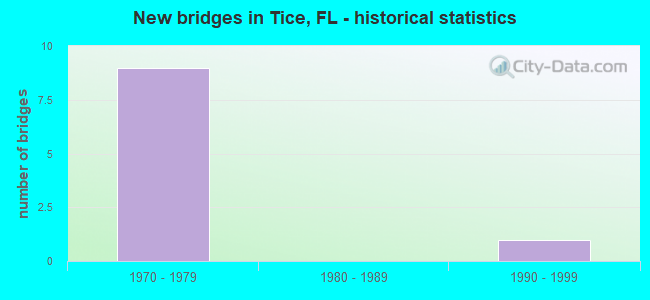
- New bridges - historical statistics
- 91970-1979
- 11990-1999


- Bridge Condition - Deck
- 85.7%Good
- 14.3%Fair

- Bridge Condition - Superstructure
- 85.7%Good
- 14.3%Fair

- Bridge Condition - Channel
- 75.0%Good
- 25.0%Satisfactory
Find on map >> Show street view
Structure Number: 120092, Location: 0.9 MI. South of SR-80 (Lat: 26.670833, Lng: -81.799639), Route carried "on" structure: City street , Year Built: 1977, Status: Open, Structure Length: 8.05m (26.41ft), Average Daily Traffic: 4,100 (year 2021), Truck Traffic: 13%, Average Future Daily Traffic: 7,114 (year 2041), Design Load: HS 20, Features Intersected: I-75 (SR-93), Facility Carried by Structure: TICE STREET
Minimum Vertical Clearance: 30+ m (98+ ft), Kilometerpoint: 2.255, Lanes on structure: 2, Lanes under structure: 8, Owner: State Highway Agency, Approaching Roadway Width: 10.7m (35.1ft), Material/Design: Prestressed concrete, Design/Construction: Stringer/Multi-beam, Number Of Spans In Main Unit: 4, Length of Maximum Span: 30.8m (101.0ft), Curb-To-Curb Width: 12.2m (40.0ft), Out-to-Out Width: 13.4m (44.0ft)
Condition: Deck: Good, Superstructure: Good, Substructure: Good, Operating Rating: 56.2 metric tons, Method Used To Determine Operating Rating: Allowable Stress (AS), Inventory Rating: 39.0 metric tons, Method Used To Determine Inventory Rating: Allowable Stress (AS), Structural Evaluation: Better than present minimum criteria, Deck Geometry: Equal to present minimum criteria, Underclear: Somewhat better than minimum adequacy, Approach Roadway Alignment: Equal to present desirable criteria, Designated Inspection Frequency: Every 24 months, Inspection Date: June 2021, Deck Structure Type: Concrete Cast-file-Place
Find on map >> Show street view
Structure Number: 120093, Location: 2.2 Mi. S of SR-78 (Lat: 26.684036, Lng: -81.798858), Route carried "on" structure: Interstate 75, Year Built: 1978, Year Reconstructed: 2013, Status: Open, Structure Length: 7.62m (25.00ft), Average Daily Traffic: 35,000 (year 2021), Truck Traffic: 17%, Average Future Daily Traffic: 43,750 (year 2041), Design Load: HS 20, Features Intersected: SR-80 (PALM BCH BLVD)
Minimum Vertical Clearance: 30+ m (98+ ft), Kilometerpoint: 41.791, Lanes on structure: 3, Lanes under structure: 11, Base Highway Network: Yes, Owner: State Highway Agency, Approaching Roadway Width: 17.0m (55.8ft), Skew: 3 degrees, Material/Design: Steel, Design/Construction: Stringer/Multi-beam, Number Of Spans In Main Unit: 3, Length of Maximum Span: 38.1m (125.0ft), Curb-To-Curb Width: 17.0m (55.8ft), Out-to-Out Width: 18.0m (59.1ft)
Condition: Deck: Good, Superstructure: Good, Substructure: Good, Operating Rating: 67.9 metric tons, Method Used To Determine Operating Rating: Load Factor (LF), Inventory Rating: 40.9 metric tons, Method Used To Determine Inventory Rating: Load Factor (LF), Structural Evaluation: Better than present minimum criteria, Deck Geometry: Equal to present minimum criteria, Underclear: High priority of corrective action, Approach Roadway Alignment: Equal to present desirable criteria, Designated Inspection Frequency: Every 24 months, Inspection Date: June 2021, Deck Structure Type: Concrete Cast-file-Place
Find on map >> Show street view
Structure Number: 120094, Location: 2.2 Mi. S of SR-78 (Lat: 26.684167, Lng: -81.798556), Route carried "on" structure: Interstate 75, Year Built: 1978, Year Reconstructed: 2013, Status: Open, Structure Length: 7.65m (25.10ft), Average Daily Traffic: 35,000 (year 2021), Truck Traffic: 17%, Average Future Daily Traffic: 43,750 (year 2041), Design Load: HS 20, Features Intersected: SR 80 (PALM BCH BLVD)
Minimum Vertical Clearance: 30+ m (98+ ft), Kilometerpoint: 41.812, Lanes on structure: 3, Lanes under structure: 11, Base Highway Network: Yes, Owner: State Highway Agency, Approaching Roadway Width: 17.1m (56.1ft), Skew: 3 degrees, Material/Design: Steel, Design/Construction: Stringer/Multi-beam, Number Of Spans In Main Unit: 3, Length of Maximum Span: 37.9m (124.3ft), Curb-To-Curb Width: 17.1m (56.1ft), Out-to-Out Width: 18.0m (59.1ft)
Condition: Deck: Good, Superstructure: Good, Substructure: Good, Operating Rating: 67.9 metric tons, Method Used To Determine Operating Rating: Load Factor (LF), Inventory Rating: 40.9 metric tons, Method Used To Determine Inventory Rating: Load Factor (LF), Structural Evaluation: Better than present minimum criteria, Deck Geometry: Equal to present minimum criteria, Underclear: High priority of corrective action, Approach Roadway Alignment: Equal to present desirable criteria, Designated Inspection Frequency: Every 24 months, Inspection Date: June 2021, Deck Structure Type: Concrete Cast-file-Place
Find on map >> Show street view
Structure Number: 124081, Location: 0.7 MI SOUTH OF SR-80 (Lat: 26.665192, Lng: -81.812306), Route carried "on" structure: County highway , Year Built: 1993, Status: Open, Structure Length: 0.95m (3.12ft), Average Daily Traffic: 8,600 (year 2021), Truck Traffic: 10%, Average Future Daily Traffic: 9,030 (year 2041), Design Load: HS 20, Features Intersected: BILLYS CREEK, Facility Carried by Structure: ORTIZ AVENUE
Minimum Vertical Clearance: 30+ m (98+ ft), Kilometerpoint: 16.634, Lanes on structure: 2, Owner: County Highway Agency, Approaching Roadway Width: 11.4m (37.4ft), Material/Design: Concrete, Design/Construction: Frame, Number Of Spans In Main Unit: 1, Length of Maximum Span: 9.5m (31.2ft), Curb-To-Curb Width: 11.4m (37.4ft), Out-to-Out Width: 12.4m (40.7ft)
Condition: Deck: Good, Superstructure: Good, Substructure: Good, Channel: Satisfactory, Operating Rating: 62.1 metric tons, Method Used To Determine Operating Rating: Load Factor (LF), Inventory Rating: 37.2 metric tons, Method Used To Determine Inventory Rating: Load Factor (LF), Structural Evaluation: Better than present minimum criteria, Deck Geometry: Meets minimum limits, Waterway Adequacy: Equal to present desirable criteria, Approach Roadway Alignment: Equal to present desirable criteria, Designated Inspection Frequency: Every 24 months, Inspection Date: July 2021, Deck Structure Type: Other, Wearing Surface/Protective System: Wearing Surface: Bituminous
Find on map >> Show street view
Structure Number: 125003, Location: 0.2MI S OF SR-80 (Lat: 26.654269, Lng: -81.840433), Route carried "on" structure: City street , Year Built: 1970, Status: Posted for load, Structure Length: 1.83m (6.00ft), Average Daily Traffic: 14,400 (year 2021), Truck Traffic: 10%, Average Future Daily Traffic: 18,800 (year 2041), Features Intersected: BILLY CREEK, Facility Carried by Structure: VERONICA SHOEMAKER
Minimum Vertical Clearance: 30+ m (98+ ft), Kilometerpoint: 0.645, Lanes on structure: 2, Owner: City or Municipal Highway Agency, Approaching Roadway Width: 8.1m (26.6ft), Material/Design: Prestressed concrete, Design/Construction: Channel Beam, Number Of Spans In Main Unit: 2, Length of Maximum Span: 9.1m (29.9ft), Curb or Sidewalk Widths: Left: 1.0m (3.3ft), Right: 0.3m (1.0ft), Curb-To-Curb Width: 8.1m (26.6ft), Out-to-Out Width: 9.7m (31.8ft)
Condition: Deck: Good, Superstructure: Good, Substructure: Good, Channel: Good, Operating Rating: 34.3 metric tons, Method Used To Determine Operating Rating: Load Factor (LF), Inventory Rating: 14.7 metric tons, Method Used To Determine Inventory Rating: Load Factor (LF), Structural Evaluation: High priority of corrective action, Deck Geometry: High priority of replacement, Waterway Adequacy: Equal to present desirable criteria, Approach Roadway Alignment: Equal to present desirable criteria, Bridge Posting: Required (Relationship of Operating Rating to Maximum Legal Load: 10.0 - 19.9% below), Designated Inspection Frequency: Every 24 months, Other Special Inspection Frequency: Every 12 months, Inspection Date: October 2021, Other Special Inspection Date: October 2021, Deck Structure Type: Concrete Cast-file-Place, Wearing Surface/Protective System: Wearing Surface: Bituminous
Find on map >> Show street view
Structure Number: 125004, Location: 0.4 MILE SOUTH OF SR 80 (Lat: 26.658333, Lng: -81.828333), Route carried "on" structure: County highway , Year Built: 1970, Status: Open, Structure Length: 1.89m (6.20ft), Average Daily Traffic: 3,500 (year 2021), Truck Traffic: 5%, Average Future Daily Traffic: 3,675 (year 2041), Features Intersected: BILLY'S CREEK, Facility Carried by Structure: MARSH AVENUE
Minimum Vertical Clearance: 30+ m (98+ ft), Kilometerpoint: 1.191, Lanes on structure: 2, Owner: County Highway Agency, Approaching Roadway Width: 8.0m (26.2ft), Material/Design: Prestressed concrete, Design/Construction: Slab, Number Of Spans In Main Unit: 2, Length of Maximum Span: 9.4m (30.8ft), Curb or Sidewalk Widths: Left: 0.0m, Right: 1.3m (4.3ft), Curb-To-Curb Width: 8.0m (26.2ft), Out-to-Out Width: 10.5m (34.4ft)
Condition: Deck: Good, Superstructure: Good, Substructure: Good, Channel: Good, Operating Rating: 66.0 metric tons, Method Used To Determine Operating Rating: Load Factor (LF), Inventory Rating: 39.6 metric tons, Method Used To Determine Inventory Rating: Load Factor (LF), Structural Evaluation: Better than present minimum criteria, Deck Geometry: High priority of corrective action, Waterway Adequacy: Better than present minimum criteria, Approach Roadway Alignment: Equal to present desirable criteria, Designated Inspection Frequency: Every 24 months, Inspection Date: July 2021, Deck Structure Type: Concrete Precast Panels, Wearing Surface/Protective System: Wearing Surface: Bituminous
Find on map >> Show street view
Structure Number: 125005, Location: 0.5 MI N of BALLARD ROAD (Lat: 26.663239, Lng: -81.818383), Route carried "on" structure: County highway , Year Built: 1970, Status: Open, Structure Length: 1.52m (4.99ft), Average Daily Traffic: 3,230 (year 2021), Truck Traffic: 1%, Average Future Daily Traffic: 4,040 (year 2041), Features Intersected: BILLY'S CREEK, Facility Carried by Structure: NUNA AVENUE
Minimum Vertical Clearance: 30+ m (98+ ft), Kilometerpoint: 1.233, Lanes on structure: 2, Owner: City or Municipal Highway Agency, Approaching Roadway Width: 8.0m (26.2ft), Material/Design: Prestressed concrete, Design/Construction: Slab, Number Of Spans In Main Unit: 2, Length of Maximum Span: 7.6m (24.9ft), Curb or Sidewalk Widths: Left: 1.1m (3.6ft), Right: 1.1m (3.6ft), Curb-To-Curb Width: 8.0m (26.2ft), Out-to-Out Width: 10.8m (35.4ft)
Condition: Deck: Fair, Superstructure: Fair, Substructure: Good, Channel: Good, Operating Rating: 47.7 metric tons, Method Used To Determine Operating Rating: Load Factor (LF), Inventory Rating: 28.8 metric tons, Method Used To Determine Inventory Rating: Load Factor (LF), Structural Evaluation: Somewhat better than minimum adequacy, Deck Geometry: High priority of corrective action, Waterway Adequacy: Better than present minimum criteria, Approach Roadway Alignment: Equal to present desirable criteria, Designated Inspection Frequency: Every 24 months, Inspection Date: July 2021, Deck Structure Type: Concrete Precast Panels, Wearing Surface/Protective System: Wearing Surface: Bituminous
Find on map >> Show street view
Structure Number: 120092, Location: 0.9 MI. South of SR-80 (Lat: 26.670833, Lng: -81.799639), Route carried "under" structure: Interstate 75, Year Built: 1977, Structure Length: 0. m, Average Daily Traffic: 84,000 (year 2021), Truck Traffic: 17%, Features Intersected: I-75 (SR-93), Facility Carried by Structure: TICE STREET
Minimum Vertical Clearance: 4.88m (16.01ft), Kilometerpoint: 40.444, Lanes on structure: 2, Lanes under structure: 8, Material/Design: Prestressed concrete, Design/Construction: Stringer/Multi-beam, Length of Maximum Span: 30.8m (101.0ft)
Find on map >> Show street view
Structure Number: 120093, Location: 2.2 Mi. S of SR-78 (Lat: 26.684036, Lng: -81.798858), Route carried "under" structure: State highway 80, Year Built: 1978, Structure Length: 0. m, Average Daily Traffic: 33,500 (year 2021), Truck Traffic: 9%, Features Intersected: SR-80 (PALM BCH BLVD), Facility Carried by Structure: I-75 SB (SR-93)
Minimum Vertical Clearance: 4.88m (16.01ft), Kilometerpoint: 8.919, Lanes on structure: 3, Lanes under structure: 11, Material/Design: Steel, Design/Construction: Stringer/Multi-beam, Length of Maximum Span: 38.1m (125.0ft)
Find on map >> Show street view
Structure Number: 120094, Location: 2.2 Mi. S of SR-78 (Lat: 26.684167, Lng: -81.798556), Route carried "under" structure: State highway 80, Year Built: 1978, Structure Length: 0. m, Average Daily Traffic: 33,500 (year 2021), Truck Traffic: 12%, Features Intersected: SR 80 (PALM BCH BLVD), Facility Carried by Structure: I-75 NB (SR-93)
Minimum Vertical Clearance: 4.88m (16.01ft), Kilometerpoint: 8.961, Lanes on structure: 3, Lanes under structure: 11, Material/Design: Steel, Design/Construction: Stringer/Multi-beam, Length of Maximum Span: 37.9m (124.3ft)