Bridge Statistics for Titusville, Florida (FL)
Condition, Traffic, Stress, Structural Evaluation, Project Costs
- National Bridge Inventory (NBI) Statistics
- 34Number of bridges
- 1,204ft / 367mTotal length
- $599,000Total costs
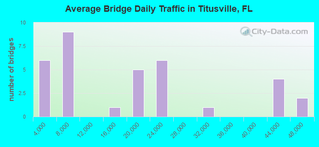
- 590,659Total average daily traffic
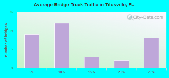
- 84,411Total average daily truck traffic
- National Bridge Inventory (NBI) Registered Bridges for Titusville
- No street view available for this location
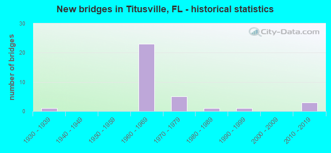
- New bridges - historical statistics
- 11930-1939
- 231960-1969
- 51970-1979
- 11980-1989
- 11990-1999
- 32010-2019
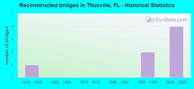
- Reconstructed bridges - Historical Statistics
- 11950-1959
- 01960-1969
- 01970-1979
- 01980-1989
- 21990-1999
- 42000-2009
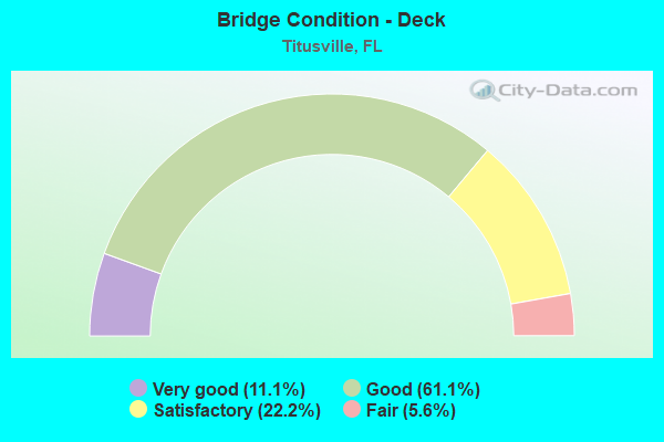
- Bridge Condition - Deck
- 11.1%Very good
- 61.1%Good
- 22.2%Satisfactory
- 5.6%Fair
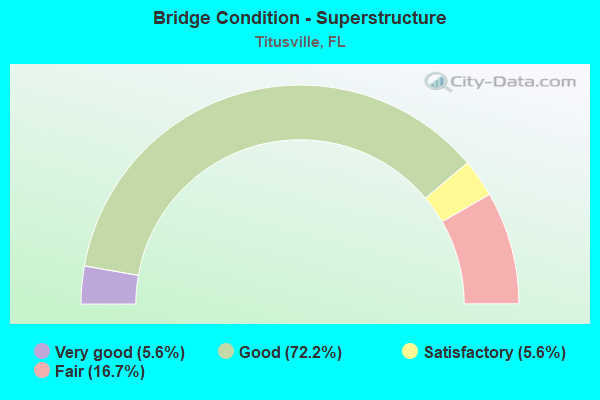
- Bridge Condition - Superstructure
- 5.6%Very good
- 72.2%Good
- 5.6%Satisfactory
- 16.7%Fair
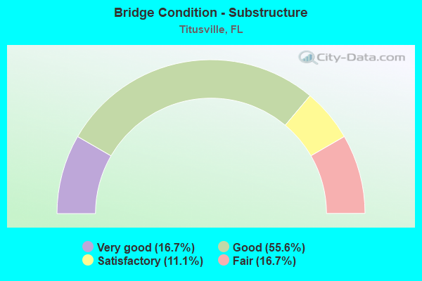
- Bridge Condition - Substructure
- 16.7%Very good
- 55.6%Good
- 11.1%Satisfactory
- 16.7%Fair
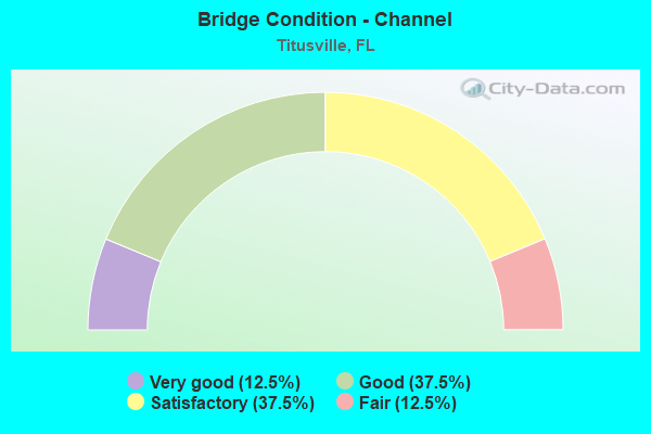
- Bridge Condition - Channel
- 12.5%Very good
- 37.5%Good
- 37.5%Satisfactory
- 12.5%Fair
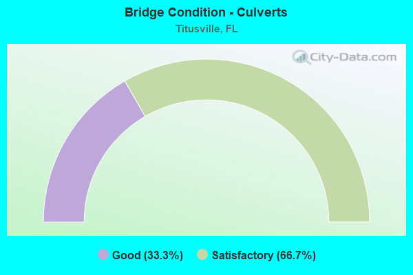
- Bridge Condition - Culverts
- 33.3%Good
- 66.7%Satisfactory
Find on map >> Show street view
Structure Number: 700002, Location: SR-405 WB - FECRR (Lat: 28.527869, Lng: -80.790875), Route carried "on" structure: State highway 405, Year Built: 1969, Status: Open, Structure Length: 5.75m (18.86ft), Average Daily Traffic: 7,550 (year 2020), Truck Traffic: 4%, Average Future Daily Traffic: 13,099 (year 2042), Design Load: HS 20, Features Intersected: FECRR
Minimum Vertical Clearance: 30+ m (98+ ft), Kilometerpoint: 6.642, Lanes on structure: 3, Owner: State Highway Agency, Approaching Roadway Width: 9.1m (29.9ft), Skew: 1 degrees, Material/Design: Prestressed concrete, Design/Construction: Stringer/Multi-beam, Number Of Spans In Main Unit: 3, Length of Maximum Span: 22.9m (75.1ft), Curb-To-Curb Width: 12.5m (41.0ft), Out-to-Out Width: 14.0m (45.9ft)
Condition: Deck: Good, Superstructure: Good, Substructure: Good, Operating Rating: 65.8 metric tons, Method Used To Determine Operating Rating: Load Factor (LF), Inventory Rating: 40.2 metric tons, Method Used To Determine Inventory Rating: Load Factor (LF), Structural Evaluation: Better than present minimum criteria, Deck Geometry: Meets minimum limits, Underclear: Meets minimum limits, Approach Roadway Alignment: Equal to present desirable criteria, Designated Inspection Frequency: Every 24 months, Inspection Date: November 2021, Deck Structure Type: Concrete Cast-file-Place, Wearing Surface/Protective System: Wearing Surface: Monolithic Concrete
Find on map >> Show street view
Structure Number: 700012, Location: US-1 - FECRR (Lat: 28.619386, Lng: -80.810697), Route carried "on" structure: US 1, Year Built: 1936, Year Reconstructed: 1961, Status: Open, Structure Length: 3.55m (11.65ft), Average Daily Traffic: 19,700 (year 2020), Truck Traffic: 6%, Average Future Daily Traffic: 34,180 (year 2042), Design Load: H 20, Features Intersected: FECRR
Minimum Vertical Clearance: 30+ m (98+ ft), Kilometerpoint: 7.200, Lanes on structure: 4, Base Highway Network: Yes, Owner: State Highway Agency, Approaching Roadway Width: 18.3m (60.0ft), Skew: 21 degrees, Material/Design: Concrete, Design/Construction: Tee Beam, Number Of Spans In Main Unit: 3, Length of Maximum Span: 11.4m (37.4ft), Curb or Sidewalk Widths: Left: 1.2m (3.9ft), Right: 1.2m (3.9ft), Curb-To-Curb Width: 18.3m (60.0ft), Out-to-Out Width: 24.1m (79.1ft)
Condition: Deck: Satisfactory, Superstructure: Satisfactory, Substructure: Satisfactory, Operating Rating: 55.0 metric tons, Method Used To Determine Operating Rating: Load Factor (LF), Inventory Rating: 32.9 metric tons, Method Used To Determine Inventory Rating: Load Factor (LF), Structural Evaluation: Equal to present minimum criteria, Deck Geometry: Somewhat better than minimum adequacy, Underclear: Meets minimum limits, Approach Roadway Alignment: Equal to present desirable criteria, Designated Inspection Frequency: Every 24 months, Inspection Date: September 2021, Deck Structure Type: Concrete Cast-file-Place, Wearing Surface/Protective System: Wearing Surface: Bituminous
Find on map >> Show street view
Structure Number: 700058, Location: I-95 SB over SR-50 (Lat: 28.551692, Lng: -80.851758), Route carried "on" structure: Interstate 95, Year Built: 1965, Year Reconstructed: 2013, Status: Open, Structure Length: 6.28m (20.60ft), Average Daily Traffic: 20,250 (year 2020), Truck Traffic: 23%, Average Future Daily Traffic: 35,134 (year 2042), Design Load: HL 93, Features Intersected: SR-50
Minimum Vertical Clearance: 30+ m (98+ ft), Kilometerpoint: 22.742, Lanes on structure: 3, Lanes under structure: 6, Base Highway Network: Yes, Owner: State Highway Agency, Approaching Roadway Width: 17.1m (56.1ft), Skew: 2 degrees, Material/Design: Prestressed concrete, Design/Construction: Stringer/Multi-beam, Number Of Spans In Main Unit: 4, Length of Maximum Span: 18.6m (61.0ft), Curb-To-Curb Width: 17.1m (56.1ft), Out-to-Out Width: 18.0m (59.1ft)
Condition: Deck: Good, Superstructure: Good, Substructure: Good, Operating Rating: 49.0 metric tons, Method Used To Determine Operating Rating: Load and Resistance Factor (LRFR), Inventory Rating: 36.6 metric tons, Method Used To Determine Inventory Rating: Load and Resistance Factor (LRFR), Structural Evaluation: Better than present minimum criteria, Deck Geometry: Equal to present minimum criteria, Underclear: Somewhat better than minimum adequacy, Approach Roadway Alignment: Equal to present desirable criteria, Designated Inspection Frequency: Every 24 months, Inspection Date: August 2021, Deck Structure Type: Concrete Cast-file-Place
Find on map >> Show street view
Structure Number: 700059, Location: I-95 SB over SR-406 (Lat: 28.616272, Lng: -80.851350), Route carried "on" structure: Interstate 95, Year Built: 1963, Year Reconstructed: 2013, Status: Open, Structure Length: 5.43m (17.81ft), Average Daily Traffic: 20,000 (year 2020), Truck Traffic: 23%, Average Future Daily Traffic: 34,700 (year 2042), Design Load: HL 93, Features Intersected: SR-406
Minimum Vertical Clearance: 30+ m (98+ ft), Kilometerpoint: 29.892, Lanes on structure: 3, Lanes under structure: 4, Base Highway Network: Yes, Owner: State Highway Agency, Approaching Roadway Width: 17.1m (56.1ft), Skew: 3 degrees, Material/Design: Prestressed concrete, Design/Construction: Stringer/Multi-beam, Number Of Spans In Main Unit: 3, Length of Maximum Span: 28.6m (93.8ft), Curb-To-Curb Width: 17.1m (56.1ft), Out-to-Out Width: 18.1m (59.4ft)
Condition: Deck: Good, Superstructure: Good, Substructure: Very good, Operating Rating: 40.8 metric tons, Method Used To Determine Operating Rating: Load and Resistance Factor (LRFR), Inventory Rating: 32.7 metric tons, Method Used To Determine Inventory Rating: Load and Resistance Factor (LRFR), Structural Evaluation: Better than present minimum criteria, Deck Geometry: Equal to present minimum criteria, Underclear: Meets minimum limits, Approach Roadway Alignment: Equal to present desirable criteria, Designated Inspection Frequency: Every 24 months, Inspection Date: August 2021, Deck Structure Type: Concrete Cast-file-Place
Find on map >> Show street view
Structure Number: 70009, Location: 2.9 Mi East of SR-528 (Lat: 28.486722, Lng: -80.848806), Route carried "on" structure: State highway 407, Year Built: 1973, Year Reconstructed: 1998, Status: Open, Structure Length: 2.40m (7.87ft), Average Daily Traffic: 6,747 (year 2020), Truck Traffic: 11%, Average Future Daily Traffic: 11,706 (year 2042), Design Load: HS 20, Features Intersected: Kings Road
Minimum Vertical Clearance: 30+ m (98+ ft), Kilometerpoint: 5.052, Lanes on structure: 2, Lanes under structure: 1, Base Highway Network: Yes, Owner: State Toll Authority, Maintenance Responsibility: State Highway Agency, Approaching Roadway Width: 11.8m (38.7ft), Material/Design: Prestressed concrete, Design/Construction: Stringer/Multi-beam, Number Of Spans In Main Unit: 1, Length of Maximum Span: 23.4m (76.8ft), Curb-To-Curb Width: 12.3m (40.4ft), Out-to-Out Width: 13.3m (43.6ft)
Condition: Deck: Good, Superstructure: Good, Substructure: Very good, Operating Rating: 88.6 metric tons, Method Used To Determine Operating Rating: Load Factor (LF), Inventory Rating: 53.2 metric tons, Method Used To Determine Inventory Rating: Load Factor (LF), Structural Evaluation: Better than present minimum criteria, Deck Geometry: Somewhat better than minimum adequacy, Approach Roadway Alignment: Equal to present desirable criteria, Designated Inspection Frequency: Every 24 months, Inspection Date: August 2020, Deck Structure Type: Concrete Cast-file-Place
Find on map >> Show street view
Structure Number: 700091, Location: 4.2MI NORTH OF SR-528 (Lat: 28.501606, Lng: -80.838581), Route carried "on" structure: State highway 407, Year Built: 1972, Year Reconstructed: 1998, Status: Open, Structure Length: 7.91m (25.95ft), Average Daily Traffic: 6,747 (year 2020), Truck Traffic: 11%, Average Future Daily Traffic: 11,706 (year 2042), Design Load: HS 20, Features Intersected: I-95 (SR-9)
Minimum Vertical Clearance: 30+ m (98+ ft), Kilometerpoint: 6.948, Lanes on structure: 3, Lanes under structure: 6, Base Highway Network: Yes, Owner: State Toll Authority, Maintenance Responsibility: State Highway Agency, Approaching Roadway Width: 11.6m (38.1ft), Skew: 2 degrees, Material/Design: Prestressed concrete, Design/Construction: Stringer/Multi-beam, Number Of Spans In Main Unit: 4, Length of Maximum Span: 29.3m (96.1ft), Curb-To-Curb Width: 15.8m (51.8ft), Out-to-Out Width: 16.8m (55.1ft)
Condition: Deck: Good, Superstructure: Good, Substructure: Good, Operating Rating: 74.9 metric tons, Method Used To Determine Operating Rating: Load Factor (LF), Inventory Rating: 45.0 metric tons, Method Used To Determine Inventory Rating: Load Factor (LF), Structural Evaluation: Better than present minimum criteria, Deck Geometry: Somewhat better than minimum adequacy, Underclear: Somewhat better than minimum adequacy, Approach Roadway Alignment: Equal to present desirable criteria, Length Of Structure Improvement: 7.83m (25.69ft), Designated Inspection Frequency: Every 24 months, Inspection Date: August 2020, Bridge Improvement Cost: $78,000, Total Project Cost: $281,000, Deck Structure Type: Concrete Cast-file-Place
Find on map >> Show street view
Structure Number: 700103, Location: SR-405 EB - FECRR (Lat: 28.527672, Lng: -80.790806), Route carried "on" structure: State highway 405, Year Built: 1969, Status: Open, Structure Length: 5.75m (18.86ft), Average Daily Traffic: 7,550 (year 2020), Truck Traffic: 4%, Average Future Daily Traffic: 13,099 (year 2042), Design Load: HS 20, Features Intersected: FECRR
Minimum Vertical Clearance: 30+ m (98+ ft), Kilometerpoint: 6.642, Lanes on structure: 3, Owner: State Highway Agency, Approaching Roadway Width: 9.1m (29.9ft), Skew: 1 degrees, Material/Design: Prestressed concrete, Design/Construction: Stringer/Multi-beam, Number Of Spans In Main Unit: 3, Length of Maximum Span: 22.9m (75.1ft), Curb-To-Curb Width: 12.5m (41.0ft), Out-to-Out Width: 14.0m (45.9ft)
Condition: Deck: Satisfactory, Superstructure: Good, Substructure: Good, Operating Rating: 65.8 metric tons, Method Used To Determine Operating Rating: Load Factor (LF), Inventory Rating: 40.2 metric tons, Method Used To Determine Inventory Rating: Load Factor (LF), Structural Evaluation: Better than present minimum criteria, Deck Geometry: Meets minimum limits, Underclear: Meets minimum limits, Approach Roadway Alignment: Equal to present desirable criteria, Designated Inspection Frequency: Every 24 months, Inspection Date: November 2021, Deck Structure Type: Concrete Cast-file-Place, Wearing Surface/Protective System: Wearing Surface: Monolithic Concrete
Find on map >> Show street view
Structure Number: 700116, Location: SR-405 EB - US-1 (Lat: 28.527664, Lng: -80.789442), Route carried "on" structure: State highway 405, Year Built: 1964, Status: Open, Structure Length: 6.72m (22.05ft), Average Daily Traffic: 7,550 (year 2020), Truck Traffic: 4%, Average Future Daily Traffic: 13,099 (year 2042), Design Load: HS 20, Features Intersected: US-1
Minimum Vertical Clearance: 30+ m (98+ ft), Kilometerpoint: 6.774, Lanes on structure: 3, Lanes under structure: 6, Owner: State Highway Agency, Approaching Roadway Width: 10.7m (35.1ft), Skew: 1 degrees, Material/Design: Prestressed concrete, Design/Construction: Stringer/Multi-beam, Number Of Spans In Main Unit: 4, Length of Maximum Span: 20.4m (66.9ft), Curb-To-Curb Width: 12.0m (39.4ft), Out-to-Out Width: 14.1m (46.3ft)
Condition: Deck: Good, Superstructure: Good, Substructure: Satisfactory, Operating Rating: 46.3 metric tons, Method Used To Determine Operating Rating: Load and Resistance Factor (LRFR), Inventory Rating: 35.7 metric tons, Method Used To Determine Inventory Rating: Load and Resistance Factor (LRFR), Structural Evaluation: Equal to present minimum criteria, Deck Geometry: Meets minimum limits, Underclear: Equal to present minimum criteria, Approach Roadway Alignment: Equal to present desirable criteria, Designated Inspection Frequency: Every 24 months, Inspection Date: December 2021, Deck Structure Type: Concrete Cast-file-Place, Wearing Surface/Protective System: Wearing Surface: Bituminous
Find on map >> Show street view
Structure Number: 70013, Location: Ranch Rd. - I-95 (Lat: 28.486525, Lng: -80.826564), Route carried "on" structure: County highway , Year Built: 1965, Status: Open, Structure Length: 8.14m (26.71ft), Average Daily Traffic: 55 (year 2021), Truck Traffic: 5%, Average Future Daily Traffic: 95 (year 2041), Design Load: H 20, Features Intersected: I-95, Facility Carried by Structure: Ranch Rd.
Minimum Vertical Clearance: 30+ m (98+ ft), Kilometerpoint: 0.000, Lanes on structure: 2, Lanes under structure: 6, Owner: State Highway Agency, Approaching Roadway Width: 8.5m (27.9ft), Skew: 3 degrees, Material/Design: Prestressed concrete, Design/Construction: Stringer/Multi-beam, Number Of Spans In Main Unit: 4, Length of Maximum Span: 27.2m (89.2ft), Curb or Sidewalk Widths: Left: 0.6m (2.0ft), Right: 0.6m (2.0ft), Curb-To-Curb Width: 8.5m (27.9ft), Out-to-Out Width: 10.4m (34.1ft)
Condition: Deck: Good, Superstructure: Good, Substructure: Good, Operating Rating: 52.1 metric tons, Method Used To Determine Operating Rating: Load Factor (LF), Inventory Rating: 32.3 metric tons, Method Used To Determine Inventory Rating: Load Factor (LF), Structural Evaluation: Better than present minimum criteria, Deck Geometry: Better than present minimum criteria, Underclear: Somewhat better than minimum adequacy, Approach Roadway Alignment: Equal to present desirable criteria, Designated Inspection Frequency: Every 24 months, Inspection Date: January 2021, Deck Structure Type: Concrete Cast-file-Place
Find on map >> Show street view
Structure Number: 700132, Location: I-95 NB over SR-50 (Lat: 28.551839, Lng: -80.851408), Route carried "on" structure: Interstate 95, Year Built: 1965, Year Reconstructed: 2013, Status: Open, Structure Length: 6.29m (20.64ft), Average Daily Traffic: 20,250 (year 2020), Truck Traffic: 23%, Average Future Daily Traffic: 35,134 (year 2042), Design Load: HL 93, Features Intersected: SR-50
Minimum Vertical Clearance: 30+ m (98+ ft), Kilometerpoint: 22.742, Lanes on structure: 3, Lanes under structure: 6, Base Highway Network: Yes, Owner: State Highway Agency, Approaching Roadway Width: 17.1m (56.1ft), Skew: 2 degrees, Material/Design: Prestressed concrete, Design/Construction: Stringer/Multi-beam, Number Of Spans In Main Unit: 4, Length of Maximum Span: 18.6m (61.0ft), Curb-To-Curb Width: 17.1m (56.1ft), Out-to-Out Width: 18.0m (59.1ft)
Condition: Deck: Good, Superstructure: Good, Substructure: Good, Operating Rating: 49.0 metric tons, Method Used To Determine Operating Rating: Load and Resistance Factor (LRFR), Inventory Rating: 36.6 metric tons, Method Used To Determine Inventory Rating: Load and Resistance Factor (LRFR), Structural Evaluation: Better than present minimum criteria, Deck Geometry: Equal to present minimum criteria, Underclear: Somewhat better than minimum adequacy, Approach Roadway Alignment: Equal to present desirable criteria, Designated Inspection Frequency: Every 24 months, Inspection Date: August 2021, Deck Structure Type: Concrete Cast-file-Place
Find on map >> Show street view
Structure Number: 700133, Location: 0.25 Mi. West of SR-405 (Lat: 28.585550, Lng: -80.851378), Route carried "on" structure: County highway , Year Built: 1965, Status: Open, Structure Length: 6.46m (21.19ft), Average Daily Traffic: 1,200 (year 2020), Truck Traffic: 5%, Average Future Daily Traffic: 2,082 (year 2042), Design Load: H 20, Features Intersected: I-95, Facility Carried by Structure: Fox Lake Rd.
Minimum Vertical Clearance: 30+ m (98+ ft), Kilometerpoint: 0.369, Lanes on structure: 2, Lanes under structure: 6, Owner: State Highway Agency, Approaching Roadway Width: 7.4m (24.3ft), Material/Design: Prestressed concrete, Design/Construction: Stringer/Multi-beam, Number Of Spans In Main Unit: 4, Length of Maximum Span: 21.1m (69.2ft), Curb or Sidewalk Widths: Left: 0.6m (2.0ft), Right: 0.6m (2.0ft), Curb-To-Curb Width: 8.5m (27.9ft), Out-to-Out Width: 10.4m (34.1ft)
Condition: Deck: Good, Superstructure: Good, Substructure: Good, Operating Rating: 71.6 metric tons, Method Used To Determine Operating Rating: Load Factor (LF), Inventory Rating: 44.3 metric tons, Method Used To Determine Inventory Rating: Load Factor (LF), Structural Evaluation: Better than present minimum criteria, Deck Geometry: Somewhat better than minimum adequacy, Underclear: Meets minimum limits, Approach Roadway Alignment: Equal to present desirable criteria, Designated Inspection Frequency: Every 24 months, Inspection Date: December 2020, Deck Structure Type: Concrete Cast-file-Place
Find on map >> Show street view
Structure Number: 700134, Location: I-95 NB over SR-406 (Lat: 28.616417, Lng: -80.851050), Route carried "on" structure: Interstate 95, Year Built: 1963, Year Reconstructed: 2013, Status: Open, Structure Length: 5.43m (17.81ft), Average Daily Traffic: 20,000 (year 2020), Truck Traffic: 23%, Average Future Daily Traffic: 34,700 (year 2042), Design Load: HL 93, Features Intersected: SR-406
Minimum Vertical Clearance: 30+ m (98+ ft), Kilometerpoint: 29.892, Lanes on structure: 3, Lanes under structure: 4, Base Highway Network: Yes, Owner: State Highway Agency, Approaching Roadway Width: 17.1m (56.1ft), Skew: 3 degrees, Material/Design: Prestressed concrete, Design/Construction: Stringer/Multi-beam, Number Of Spans In Main Unit: 3, Length of Maximum Span: 28.6m (93.8ft), Curb-To-Curb Width: 17.1m (56.1ft), Out-to-Out Width: 18.1m (59.4ft)
Condition: Deck: Good, Superstructure: Good, Substructure: Good, Operating Rating: 40.8 metric tons, Method Used To Determine Operating Rating: Load and Resistance Factor (LRFR), Inventory Rating: 32.7 metric tons, Method Used To Determine Inventory Rating: Load and Resistance Factor (LRFR), Structural Evaluation: Better than present minimum criteria, Deck Geometry: Equal to present minimum criteria, Underclear: Meets minimum limits, Approach Roadway Alignment: Equal to present desirable criteria, Designated Inspection Frequency: Every 24 months, Inspection Date: August 2021, Deck Structure Type: Concrete Cast-file-Place
Find on map >> Show street view
Structure Number: 700135, Location: Dairy Rd - I-95 (Lat: 28.637136, Lng: -80.857783), Route carried "on" structure: County highway , Year Built: 1965, Status: Open, Structure Length: 6.82m (22.38ft), Average Daily Traffic: 5,400 (year 2020), Truck Traffic: 8%, Average Future Daily Traffic: 9,369 (year 2042), Design Load: H 20, Features Intersected: I-95, Facility Carried by Structure: Dairy Rd
Minimum Vertical Clearance: 30+ m (98+ ft), Kilometerpoint: 0.248, Lanes on structure: 2, Lanes under structure: 6, Owner: State Highway Agency, Approaching Roadway Width: 7.8m (25.6ft), Skew: 1 degrees, Material/Design: Prestressed concrete, Design/Construction: Stringer/Multi-beam, Number Of Spans In Main Unit: 4, Length of Maximum Span: 22.2m (72.8ft), Curb or Sidewalk Widths: Left: 0.6m (2.0ft), Right: 0.6m (2.0ft), Curb-To-Curb Width: 8.5m (27.9ft), Out-to-Out Width: 10.4m (34.1ft)
Condition: Deck: Good, Superstructure: Good, Substructure: Good, Operating Rating: 68.4 metric tons, Method Used To Determine Operating Rating: Load Factor (LF), Inventory Rating: 41.0 metric tons, Method Used To Determine Inventory Rating: Load Factor (LF), Structural Evaluation: Better than present minimum criteria, Deck Geometry: Meets minimum limits, Underclear: Meets minimum limits, Approach Roadway Alignment: Equal to present desirable criteria, Designated Inspection Frequency: Every 24 months, Inspection Date: Febuary 2021, Deck Structure Type: Concrete Cast-file-Place
Find on map >> Show street view
Structure Number: 700167, Location: 0.7 Mi S of SR-50 (Lat: 28.550733, Lng: -80.837003), Route carried "on" structure: State highway 405, Year Built: 1969, Status: Open, Structure Length: 0.70m (2.30ft), Average Daily Traffic: 20,500 (year 2020), Truck Traffic: 5%, Average Future Daily Traffic: 35,568 (year 2042), Design Load: HS 20+Mod, Features Intersected: Canal
Minimum Vertical Clearance: 30+ m (98+ ft), Kilometerpoint: 1.059, Lanes on structure: 4, Base Highway Network: Yes, Owner: State Highway Agency, Approaching Roadway Width: 19.7m (64.6ft), Skew: 22 degrees, Material/Design: Concrete, Design/Construction: Culvert, Number Of Spans In Main Unit: 2, Length of Maximum Span: 3.0m (9.8ft)
Condition: Channel: Satisfactory, Culverts: Good, Operating Rating: 66.1 metric tons, Method Used To Determine Operating Rating: Load Factor (LF), Inventory Rating: 39.6 metric tons, Method Used To Determine Inventory Rating: Load Factor (LF), Structural Evaluation: Better than present minimum criteria, Waterway Adequacy: Equal to present desirable criteria, Approach Roadway Alignment: Equal to present desirable criteria, Designated Inspection Frequency: Every 24 months, Underwater Inspection Frequency: Every 24 months, Inspection Date: December 2021, Underwater Inspection Date: December 2021
Find on map >> Show street view
Structure Number: 700178, Location: SR-50 1.0 Mi East of I-95 (Lat: 28.557797, Lng: -80.832939), Route carried "on" structure: State highway 50, Year Built: 1980, Status: Open, Structure Length: 1.13m (3.71ft), Average Daily Traffic: 21,500 (year 2020), Truck Traffic: 4%, Average Future Daily Traffic: 37,302 (year 2042), Design Load: HS 20+Mod, Features Intersected: Canal
Minimum Vertical Clearance: 30+ m (98+ ft), Kilometerpoint: 10.319, Lanes on structure: 5, Owner: State Highway Agency, Approaching Roadway Width: 22.3m (73.2ft), Skew: 21 degrees, Material/Design: Concrete, Design/Construction: Culvert, Number Of Spans In Main Unit: 3, Length of Maximum Span: 3.7m (12.1ft)
Condition: Channel: Good, Culverts: Satisfactory, Operating Rating: 77.4 metric tons, Method Used To Determine Operating Rating: Load Factor (LF), Inventory Rating: 46.4 metric tons, Method Used To Determine Inventory Rating: Load Factor (LF), Structural Evaluation: Equal to present minimum criteria, Waterway Adequacy: Better than present minimum criteria, Approach Roadway Alignment: Equal to present desirable criteria, Designated Inspection Frequency: Every 24 months, Inspection Date: November 2021
Find on map >> Show street view
Structure Number: 700216, Location: 2.2 Mi East of SR-528 (Lat: 28.475517, Lng: -80.856456), Route carried "on" structure: State highway 407, Year Built: 1973, Status: Open, Structure Length: 1.28m (4.20ft), Average Daily Traffic: 6,747 (year 2020), Truck Traffic: 11%, Average Future Daily Traffic: 11,706 (year 2042), Design Load: HS 20+Mod, Features Intersected: Young Canal
Minimum Vertical Clearance: 30+ m (98+ ft), Kilometerpoint: 3.615, Lanes on structure: 2, Base Highway Network: Yes, Owner: State Toll Authority, Maintenance Responsibility: State Highway Agency, Approaching Roadway Width: 9.7m (31.8ft), Skew: 3 degrees, Material/Design: Concrete, Design/Construction: Culvert, Number Of Spans In Main Unit: 3, Length of Maximum Span: 4.2m (13.8ft)
Condition: Channel: Good, Culverts: Satisfactory, Operating Rating: 69.2 metric tons, Method Used To Determine Operating Rating: Load Factor (LF), Inventory Rating: 41.5 metric tons, Method Used To Determine Inventory Rating: Load Factor (LF), Structural Evaluation: Equal to present minimum criteria, Waterway Adequacy: Better than present minimum criteria, Approach Roadway Alignment: Equal to present desirable criteria, Designated Inspection Frequency: Every 24 months, Underwater Inspection Frequency: Every 24 months, Inspection Date: August 2020, Underwater Inspection Date: August 2020
Find on map >> Show street view
Structure Number: 700227, Location: SR-406 over Indian River (Lat: 28.620253, Lng: -80.798769), Route carried "on" structure: State highway 406, Year Built: 2010, Status: Open, Structure Length: 97.81m (320.90ft), Average Daily Traffic: 3,400 (year 2020), Truck Traffic: 3%, Average Future Daily Traffic: 5,899 (year 2042), Design Load: HL 93, Features Intersected: Indian River
Minimum Vertical Clearance: 30+ m (98+ ft), Kilometerpoint: 0.000, Lanes on structure: 2, Owner: State Highway Agency, Approaching Roadway Width: 12.2m (40.0ft), Navigation Control: Yes ( Vertical Clearance: 19.8m (65.0ft), Horizontal Clearance: 38.1m (125.0ft)), Material/Design: Prestressed concrete continuous, Design/Construction: Stringer/Multi-beam, Number Of Spans In Main Unit: 21, Length of Maximum Span: 67.4m (221.1ft), Curb or Sidewalk Widths: Left: 1.5m (4.9ft), Right: 1.5m (4.9ft), Curb-To-Curb Width: 12.2m (40.0ft), Out-to-Out Width: 16.8m (55.1ft)
Condition: Deck: Very good, Superstructure: Good, Substructure: Good, Channel: Good, Operating Rating: 44.1 metric tons, Method Used To Determine Operating Rating: Load and Resistance Factor (LRFR), Inventory Rating: 33.9 metric tons, Method Used To Determine Inventory Rating: Load and Resistance Factor (LRFR), Structural Evaluation: Better than present minimum criteria, Deck Geometry: Equal to present minimum criteria, Waterway Adequacy: Equal to present desirable criteria, Approach Roadway Alignment: Equal to present desirable criteria, Designated Inspection Frequency: Every 24 months, Underwater Inspection Frequency: Every 24 months, Inspection Date: June 2021, Underwater Inspection Date: July 2021, Deck Structure Type: Concrete Cast-file-Place, Wearing Surface/Protective System: Wearing Surface: Monolithic Concrete
Find on map >> Show street view
Structure Number: 700229, Location: I-95 over Addison Canal (Lat: 28.527778, Lng: -80.851806), Route carried "on" structure: Interstate 95, Year Built: 2013, Status: Open, Structure Length: 2.74m (8.99ft), Average Daily Traffic: 40,500 (year 2020), Truck Traffic: 23%, Average Future Daily Traffic: 70,268 (year 2042), Design Load: HL 93, Features Intersected: Addison Canal
Minimum Vertical Clearance: 30+ m (98+ ft), Kilometerpoint: 20.085, Lanes on structure: 6, Base Highway Network: Yes, Owner: State Highway Agency, Approaching Roadway Width: 35.4m (116.1ft), Skew: 30 degrees, Material/Design: Prestressed concrete, Design/Construction: Stringer/Multi-beam, Number Of Spans In Main Unit: 1, Length of Maximum Span: 26.8m (87.9ft), Curb-To-Curb Width: 39.6m (129.9ft), Out-to-Out Width: 41.1m (134.8ft)
Condition: Deck: Very good, Superstructure: Very good, Substructure: Very good, Channel: Very good, Operating Rating: 38.5 metric tons, Method Used To Determine Operating Rating: Load and Resistance Factor (LRFR), Inventory Rating: 34.6 metric tons, Method Used To Determine Inventory Rating: Load and Resistance Factor (LRFR), Structural Evaluation: Equal to present desirable criteria, Deck Geometry: Superior to present desirable criteria, Waterway Adequacy: Equal to present desirable criteria, Approach Roadway Alignment: Equal to present desirable criteria, Designated Inspection Frequency: Every 24 months, Inspection Date: October 2021, Deck Structure Type: Concrete Cast-file-Place
Find on map >> Show street view
Structure Number: 704048, Location: 0.2 mile East of US-1 (Lat: 28.617889, Lng: -80.802753), Route carried "on" structure: ServiceCounty highway , Year Built: 1963, Status: Open, Structure Length: 4.36m (14.30ft), Average Daily Traffic: 304 (year 2020), Truck Traffic: 7%, Average Future Daily Traffic: 353 (year 2042), Design Load: H 20, Features Intersected: Indian River Relief, Facility Carried by Structure: Service Road
Minimum Vertical Clearance: 30+ m (98+ ft), Kilometerpoint: 0.875, Lanes on structure: 2, Owner: City or Municipal Highway Agency, Approaching Roadway Width: 7.3m (24.0ft), Material/Design: Prestressed concrete, Design/Construction: Slab, Number Of Spans In Main Unit: 4, Length of Maximum Span: 11.0m (36.1ft), Curb or Sidewalk Widths: Left: 2.1m (6.9ft), Right: 0.6m (2.0ft), Curb-To-Curb Width: 8.7m (28.5ft), Out-to-Out Width: 11.6m (38.1ft)
Condition: Deck: Fair, Superstructure: Fair, Substructure: Fair, Channel: Fair, Operating Rating: 42.7 metric tons, Method Used To Determine Operating Rating: Allowable Stress (AS), Inventory Rating: 37.6 metric tons, Method Used To Determine Inventory Rating: Allowable Stress (AS), Structural Evaluation: Somewhat better than minimum adequacy, Deck Geometry: Equal to present minimum criteria, Waterway Adequacy: Somewhat better than minimum adequacy, Approach Roadway Alignment: Equal to present desirable criteria, Designated Inspection Frequency: Every 24 months, Underwater Inspection Frequency: Every 24 months, Inspection Date: March 2020, Underwater Inspection Date: March 2020, Deck Structure Type: Concrete Precast Panels, Wearing Surface/Protective System: Wearing Surface: Bituminous
Find on map >> Show street view
Structure Number: 703001, Location: KENNEDY SPACE CENTER (Lat: 28.527456, Lng: -80.763842), Route carried "on" structure: Federal lands road , Year Built: 1964, Status: Posted for load, Structure Length: 91.23m (299.31ft), Average Daily Traffic: 6,700 (year 2019), Truck Traffic: 4%, Average Future Daily Traffic: 7,200 (year 2036), Design Load: H 20, Features Intersected: INDIAN RIVER, Facility Carried by Structure: NASA CAUSEWAY WB
Minimum Vertical Clearance: 30+ m (98+ ft), Kilometerpoint: 8.834, Lanes on structure: 2, Base Highway Network: Yes, Owner: NASA, Approaching Roadway Width: 8.5m (27.9ft), Navigation Control: Yes ( Vertical Clearance: 8.5m (27.9ft), Horizontal Clearance: 27.4m (89.9ft)), Material/Design: Steel, Design/Construction: Movable - Bascule, Number Of Spans In Main Unit: 1, Number Of Approach Spans: 55, Length of Maximum Span: 39.3m (128.9ft), Curb or Sidewalk Widths: Left: 0.4m (1.3ft), Right: 0.4m (1.3ft), Curb-To-Curb Width: 8.5m (27.9ft), Out-to-Out Width: 10.0m (32.8ft)
Condition: Deck: Satisfactory, Superstructure: Fair, Substructure: Fair, Channel: Satisfactory, Operating Rating: 20.2 metric tons, Method Used To Determine Operating Rating: Load and Resistance Factor (LRFR), Inventory Rating: 15.7 metric tons, Method Used To Determine Inventory Rating: Load and Resistance Factor (LRFR), Structural Evaluation: High priority of corrective action, Deck Geometry: High priority of corrective action, Waterway Adequacy: Equal to present desirable criteria, Approach Roadway Alignment: Equal to present minimum criteria, Bridge Posting: Required (Relationship of Operating Rating to Maximum Legal Load: > 39.9% below), Length Of Structure Improvement: 4.36m (14.30ft), Designated Inspection Frequency: Every 24 months, Critical Feature Inspection Frequency: Every 24 months, Underwater Inspection Frequency: Every 48 months, Other Special Inspection Frequency: Every 12 months, Inspection Date: September 2021, Critical Feature Inspection Date: September 2021, Underwater Inspection Date: September 2021, Other Special Inspection Date: Febuary 2022, Bridge Improvement Cost: $160,000, Total Project Cost: $159,000 ( Estimate for 2021), Deck Structure Type: Concrete Cast-file-Place, Wearing Surface/Protective System: Wearing Surface: Bituminous
Find on map >> Show street view
Structure Number: 703002, Location: KENNEDY SPACE CENTER (Lat: 28.527294, Lng: -80.763842), Route carried "on" structure: Federal lands road , Year Built: 1964, Status: Posted for load, Structure Length: 91.23m (299.31ft), Average Daily Traffic: 6,700 (year 2019), Truck Traffic: 4%, Average Future Daily Traffic: 7,200 (year 2036), Design Load: H 20, Features Intersected: INDIAN RIVER, Facility Carried by Structure: NASA CAUSEWAY EB
Minimum Vertical Clearance: 30+ m (98+ ft), Kilometerpoint: 8.834, Lanes on structure: 2, Base Highway Network: Yes, Owner: NASA, Approaching Roadway Width: 8.5m (27.9ft), Navigation Control: Yes ( Vertical Clearance: 8.5m (27.9ft), Horizontal Clearance: 27.4m (89.9ft)), Material/Design: Steel, Design/Construction: Movable - Bascule, Number Of Spans In Main Unit: 1, Number Of Approach Spans: 55, Length of Maximum Span: 39.3m (128.9ft), Curb or Sidewalk Widths: Left: 0.4m (1.3ft), Right: 0.4m (1.3ft), Curb-To-Curb Width: 8.5m (27.9ft), Out-to-Out Width: 10.0m (32.8ft)
Condition: Deck: Satisfactory, Superstructure: Fair, Substructure: Fair, Channel: Satisfactory, Operating Rating: 20.2 metric tons, Method Used To Determine Operating Rating: Load and Resistance Factor (LRFR), Inventory Rating: 15.7 metric tons, Method Used To Determine Inventory Rating: Load and Resistance Factor (LRFR), Structural Evaluation: High priority of corrective action, Deck Geometry: High priority of corrective action, Waterway Adequacy: Equal to present desirable criteria, Approach Roadway Alignment: Equal to present minimum criteria, Bridge Posting: Required (Relationship of Operating Rating to Maximum Legal Load: > 39.9% below), Length Of Structure Improvement: 4.36m (14.30ft), Designated Inspection Frequency: Every 24 months, Critical Feature Inspection Frequency: Every 24 months, Underwater Inspection Frequency: Every 48 months, Other Special Inspection Frequency: Every 12 months, Inspection Date: September 2021, Critical Feature Inspection Date: September 2021, Underwater Inspection Date: September 2021, Other Special Inspection Date: Febuary 2022, Bridge Improvement Cost: $160,000, Total Project Cost: $159,000 ( Estimate for 2021), Deck Structure Type: Concrete Cast-file-Place, Wearing Surface/Protective System: Wearing Surface: Bituminous
Find on map >> Show street view
Structure Number: 700029, Location: SR-405 WB Over US-1 (Lat: 28.527872, Lng: -80.789506), Route carried "under" structure: US 5, Year Built: 1964, Structure Length: 0. m, Average Daily Traffic: 19,000 (year 2020), Truck Traffic: 3%, Features Intersected: US-1
Minimum Vertical Clearance: 5.15m (16.90ft), Kilometerpoint: 54.018, Lanes on structure: 3, Lanes under structure: 6, Material/Design: Prestressed concrete, Design/Construction: Stringer/Multi-beam, Length of Maximum Span: 20.4m (66.9ft)
Find on map >> Show street view
Structure Number: 700058, Location: I-95 SB over SR-50 (Lat: 28.551692, Lng: -80.851758), Route carried "under" structure: State highway 50, Year Built: 1965, Structure Length: 0. m, Average Daily Traffic: 12,200 (year 2020), Truck Traffic: 5%, Features Intersected: SR-50, Facility Carried by Structure: I-95 SB
Minimum Vertical Clearance: 4.88m (16.01ft), Kilometerpoint: 8.240, Lanes on structure: 3, Lanes under structure: 6, Material/Design: Prestressed concrete, Design/Construction: Stringer/Multi-beam, Length of Maximum Span: 18.6m (61.0ft)
Find on map >> Show street view
Structure Number: 700059, Location: I-95 SB over SR-406 (Lat: 28.616272, Lng: -80.851350), Route carried "under" structure: State highway 406, Year Built: 1963, Structure Length: 0. m, Average Daily Traffic: 18,400 (year 2020), Truck Traffic: 5%, Features Intersected: SR-406, Facility Carried by Structure: I-95 SB
Minimum Vertical Clearance: 4.82m (15.81ft), Kilometerpoint: 0.212, Lanes on structure: 3, Lanes under structure: 4, Material/Design: Prestressed concrete, Design/Construction: Stringer/Multi-beam, Length of Maximum Span: 28.6m (93.8ft)
Find on map >> Show street view
Structure Number: 70009, Location: 2.9 Mi East of SR-528 (Lat: 28.486722, Lng: -80.848806), Route carried "under" structure: Other road , Year Built: 1973, Structure Length: 0. m, Average Daily Traffic: 9 (year 2012), Truck Traffic: 5%, Features Intersected: Kings Road, Facility Carried by Structure: SR-407
Minimum Vertical Clearance: 4.39m (14.40ft), Kilometerpoint: 5.069, Lanes on structure: 2, Lanes under structure: 1, Material/Design: Prestressed concrete, Design/Construction: Stringer/Multi-beam, Length of Maximum Span: 23.4m (76.8ft)
Find on map >> Show street view
Structure Number: 700091, Location: 4.2MI NORTH OF SR-528 (Lat: 28.501606, Lng: -80.838581), Route carried "under" structure: Interstate 95, Year Built: 1972, Structure Length: 0. m, Average Daily Traffic: 46,500 (year 2020), Truck Traffic: 15%, Features Intersected: I-95 (SR-9), Facility Carried by Structure: SR-407
Minimum Vertical Clearance: 5.00m (16.40ft), Kilometerpoint: 16.813, Lanes on structure: 3, Lanes under structure: 6, Material/Design: Prestressed concrete, Design/Construction: Stringer/Multi-beam, Length of Maximum Span: 29.3m (96.1ft)
Find on map >> Show street view
Structure Number: 700116, Location: SR-405 EB - US-1 (Lat: 28.527664, Lng: -80.789442), Route carried "under" structure: US 1, Year Built: 1964, Structure Length: 0. m, Average Daily Traffic: 19,000 (year 2020), Truck Traffic: 3%, Features Intersected: US-1, Facility Carried by Structure: SR-405 EB
Minimum Vertical Clearance: 4.54m (14.90ft), Kilometerpoint: 54.055, Lanes on structure: 3, Lanes under structure: 6, Material/Design: Prestressed concrete, Design/Construction: Stringer/Multi-beam, Length of Maximum Span: 20.4m (66.9ft)
Find on map >> Show street view
Structure Number: 70013, Location: Ranch Rd. - I-95 (Lat: 28.486525, Lng: -80.826564), Route carried "under" structure: Interstate 95, Year Built: 1965, Structure Length: 0. m, Average Daily Traffic: 46,500 (year 2020), Truck Traffic: 15%, Features Intersected: I-95, Facility Carried by Structure: Ranch Rd.
Minimum Vertical Clearance: 5.09m (16.70ft), Kilometerpoint: 14.763, Lanes on structure: 2, Lanes under structure: 6, Material/Design: Prestressed concrete, Design/Construction: Stringer/Multi-beam, Length of Maximum Span: 27.2m (89.2ft)
Find on map >> Show street view
Structure Number: 700132, Location: I-95 NB over SR-50 (Lat: 28.551839, Lng: -80.851408), Route carried "under" structure: State highway 50, Year Built: 1965, Structure Length: 0. m, Average Daily Traffic: 31,500 (year 2020), Truck Traffic: 8%, Features Intersected: SR-50, Facility Carried by Structure: I-95 NB
Minimum Vertical Clearance: 5.03m (16.50ft), Kilometerpoint: 8.272, Lanes on structure: 3, Lanes under structure: 6, Material/Design: Prestressed concrete, Design/Construction: Stringer/Multi-beam, Length of Maximum Span: 18.6m (61.0ft)
Find on map >> Show street view
Structure Number: 700133, Location: 0.25 Mi. West of SR-405 (Lat: 28.585550, Lng: -80.851378), Route carried "under" structure: Interstate 95, Year Built: 1965, Structure Length: 0. m, Average Daily Traffic: 40,000 (year 2020), Truck Traffic: 23%, Features Intersected: I-95, Facility Carried by Structure: Fox Lake Rd.
Minimum Vertical Clearance: 4.97m (16.31ft), Kilometerpoint: 26.503, Lanes on structure: 2, Lanes under structure: 6, Material/Design: Prestressed concrete, Design/Construction: Stringer/Multi-beam, Length of Maximum Span: 21.1m (69.2ft)
Find on map >> Show street view
Structure Number: 700134, Location: I-95 NB over SR-406 (Lat: 28.616417, Lng: -80.851050), Route carried "under" structure: State highway 406, Year Built: 1963, Structure Length: 0. m, Average Daily Traffic: 18,400 (year 2020), Truck Traffic: 5%, Features Intersected: SR-406, Facility Carried by Structure: I-95 NB
Minimum Vertical Clearance: 4.85m (15.91ft), Kilometerpoint: 0.248, Lanes on structure: 3, Lanes under structure: 4, Material/Design: Prestressed concrete, Design/Construction: Stringer/Multi-beam, Length of Maximum Span: 28.6m (93.8ft)
Find on map >> Show street view
Structure Number: 700135, Location: Dairy Rd - I-95 (Lat: 28.637136, Lng: -80.857783), Route carried "under" structure: Interstate 95, Year Built: 1965, Structure Length: 0. m, Average Daily Traffic: 43,000 (year 2020), Truck Traffic: 23%, Features Intersected: I-95, Facility Carried by Structure: Dairy Rd
Minimum Vertical Clearance: 4.94m (16.21ft), Kilometerpoint: 35.752, Lanes on structure: 2, Lanes under structure: 6, Material/Design: Prestressed concrete, Design/Construction: Stringer/Multi-beam, Length of Maximum Span: 22.2m (72.8ft)
Find on map >> Show street view
Structure Number: 709002, Location: Dairy Rd Ped. Op. I-95 (Lat: 28.637028, Lng: -80.857750), Route carried "under" structure: Interstate 95, Year Built: 1991, Structure Length: 0. m, Average Daily Traffic: 43,000 (year 2020), Truck Traffic: 23%, Features Intersected: I-95, Facility Carried by Structure: Dairy Rd. Ped
Minimum Vertical Clearance: 5.18m (16.99ft), Kilometerpoint: 32.327, Lanes under structure: 6, Material/Design: Prestressed concrete, Design/Construction: Box Beam or Girders - Multiple, Length of Maximum Span: 22.2m (72.8ft)
Find on map >> Show street view
Structure Number: 709006, Location: Titusville Trail - SR-406 (Lat: 28.615367, Lng: -80.817017), Route carried "under" structure: State highway 406, Year Built: 2015, Structure Length: 0. m, Average Daily Traffic: 3,800 (year 2016), Truck Traffic: 5%, Features Intersected: SR-406 (Garden St.), Facility Carried by Structure: Titusville Trail
Minimum Vertical Clearance: 5.91m (19.39ft), Kilometerpoint: 3.816, Lanes under structure: 4, Material/Design: Steel, Design/Construction: Truss - Thru, Length of Maximum Span: 49.1m (161.1ft)