Bridge Statistics for Tolono, Illinois (IL)
Condition, Traffic, Stress, Structural Evaluation, Project Costs
- National Bridge Inventory (NBI) Statistics
- 19Number of bridges
- 154ft / 47.0mTotal length
- 141,650Total average daily traffic
- 43,929Total average daily truck traffic
- National Bridge Inventory (NBI) Registered Bridges for Tolono
- No street view available for this location
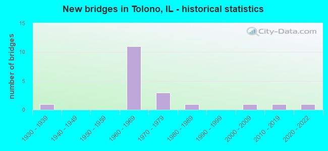
- New bridges - historical statistics
- 11930-1939
- 111960-1969
- 31970-1979
- 11980-1989
- 12000-2009
- 12010-2019
- 12020-2022


- Bridge Condition - Deck
- 6.7%Excellent
- 60.0%Good
- 26.7%Satisfactory
- 6.7%Serious

- Bridge Condition - Superstructure
- 6.7%Excellent
- 66.7%Good
- 6.7%Satisfactory
- 20.0%Fair

- Bridge Condition - Substructure
- 6.7%Excellent
- 20.0%Very good
- 46.7%Good
- 6.7%Satisfactory
- 20.0%Fair

- Bridge Condition - Channel
- 10.0%Excellent
- 30.0%Very good
- 40.0%Good
- 20.0%Satisfactory
Find on map >> Show street view
Structure Number: 100001, Location: SW OF TOLONO (Lat: 39.975111, Lng: -88.303364), Route carried "on" structure: Interstate 57, Year Built: 1963, Year Reconstructed: 2002, Status: Open, Structure Length: 4.53m (14.86ft), Average Daily Traffic: 12,900 (year 2021), Truck Traffic: 33%, Average Future Daily Traffic: 12,013 (year 2032), Design Load: HS 20+Mod, Features Intersected: N&S RR
Minimum Vertical Clearance: 30+ m (98+ ft), Kilometerpoint: 362.125, Lanes on structure: 2, Base Highway Network: Yes, Owner: State Highway Agency, Approaching Roadway Width: 12.2m (40.0ft), Skew: 1 degrees, Material/Design: Steel continuous, Design/Construction: Stringer/Multi-beam, Number Of Spans In Main Unit: 3, Length of Maximum Span: 16.2m (53.1ft), Curb-To-Curb Width: 12.6m (41.3ft), Out-to-Out Width: 13.6m (44.6ft)
Condition: Deck: Satisfactory, Superstructure: Fair, Substructure: Good, Operating Rating: 60.6 metric tons, Method Used To Determine Operating Rating: Load Factor (LF) rating reported by rating factor (RF) method using MS18 loading, Inventory Rating: 36.3 metric tons, Method Used To Determine Inventory Rating: Load Factor (LF) rating reported by rating factor (RF) method using MS18 loading, Structural Evaluation: Somewhat better than minimum adequacy, Deck Geometry: Better than present minimum criteria, Underclear: Better than present minimum criteria, Approach Roadway Alignment: Equal to present desirable criteria, Designated Inspection Frequency: Every 24 months, Inspection Date: November 2021, Deck Structure Type: Concrete Cast-file-Place, Wearing Surface/Protective System: Deck Protection: Epoxy Coated Reinforcing
Find on map >> Show street view
Structure Number: 100002, Location: SW OF TOLONO (Lat: 39.975256, Lng: -88.303369), Route carried "on" structure: Interstate 57, Year Built: 1963, Year Reconstructed: 2002, Status: Open, Structure Length: 4.53m (14.86ft), Average Daily Traffic: 12,900 (year 2021), Truck Traffic: 33%, Average Future Daily Traffic: 12,013 (year 2032), Design Load: HS 20+Mod, Features Intersected: N&S RR
Minimum Vertical Clearance: 30+ m (98+ ft), Kilometerpoint: 362.141, Lanes on structure: 2, Base Highway Network: Yes, Owner: State Highway Agency, Approaching Roadway Width: 12.2m (40.0ft), Skew: 1 degrees, Material/Design: Steel continuous, Design/Construction: Stringer/Multi-beam, Number Of Spans In Main Unit: 3, Length of Maximum Span: 16.2m (53.1ft), Curb-To-Curb Width: 12.6m (41.3ft), Out-to-Out Width: 13.6m (44.6ft)
Condition: Deck: Satisfactory, Superstructure: Fair, Substructure: Good, Operating Rating: 68.4 metric tons, Method Used To Determine Operating Rating: Load Factor (LF) rating reported by rating factor (RF) method using MS18 loading, Inventory Rating: 40.8 metric tons, Method Used To Determine Inventory Rating: Load Factor (LF) rating reported by rating factor (RF) method using MS18 loading, Structural Evaluation: Somewhat better than minimum adequacy, Deck Geometry: Better than present minimum criteria, Underclear: Better than present minimum criteria, Approach Roadway Alignment: Equal to present desirable criteria, Designated Inspection Frequency: Every 24 months, Inspection Date: November 2021, Deck Structure Type: Concrete Cast-file-Place, Wearing Surface/Protective System: Deck Protection: Epoxy Coated Reinforcing
Find on map >> Show street view
Structure Number: 100003, Location: W OF TOLONO (Lat: 39.986125, Lng: -88.303481), Route carried "on" structure: Interstate 57, Year Built: 1963, Year Reconstructed: 2003, Status: Open, Structure Length: 0.76m (2.49ft), Average Daily Traffic: 12,900 (year 2021), Truck Traffic: 33%, Average Future Daily Traffic: 12,013 (year 2032), Design Load: HS 20+Mod, Features Intersected: 2 MILE SLOUGH
Minimum Vertical Clearance: 30+ m (98+ ft), Kilometerpoint: 363.348, Lanes on structure: 2, Base Highway Network: Yes, Owner: State Highway Agency, Approaching Roadway Width: 11.6m (38.1ft), Material/Design: Concrete, Design/Construction: Slab, Number Of Spans In Main Unit: 1, Length of Maximum Span: 7.2m (23.6ft), Curb-To-Curb Width: 11.9m (39.0ft), Out-to-Out Width: 13.5m (44.3ft)
Condition: Deck: Good, Superstructure: Good, Substructure: Fair, Channel: Good, Operating Rating: 60.9 metric tons, Method Used To Determine Operating Rating: Load Factor (LF) rating reported by rating factor (RF) method using MS18 loading, Inventory Rating: 36.6 metric tons, Method Used To Determine Inventory Rating: Load Factor (LF) rating reported by rating factor (RF) method using MS18 loading, Structural Evaluation: Somewhat better than minimum adequacy, Deck Geometry: Equal to present minimum criteria, Waterway Adequacy: Equal to present desirable criteria, Approach Roadway Alignment: Equal to present desirable criteria, Designated Inspection Frequency: Every 24 months, Inspection Date: December 2020, Deck Structure Type: Concrete Cast-file-Place, Wearing Surface/Protective System: Wearing Surface: Bituminous, Membrane: Built-up
Find on map >> Show street view
Structure Number: 100004, Location: W OF TOLONO (Lat: 39.986269, Lng: -88.303483), Route carried "on" structure: Interstate 57, Year Built: 1963, Year Reconstructed: 2003, Status: Open, Structure Length: 0.76m (2.49ft), Average Daily Traffic: 12,900 (year 2021), Truck Traffic: 33%, Average Future Daily Traffic: 12,013 (year 2032), Design Load: HS 20+Mod, Features Intersected: 2 MILE SLOUGH
Minimum Vertical Clearance: 30+ m (98+ ft), Kilometerpoint: 363.364, Lanes on structure: 2, Base Highway Network: Yes, Owner: State Highway Agency, Approaching Roadway Width: 11.6m (38.1ft), Material/Design: Concrete, Design/Construction: Slab, Number Of Spans In Main Unit: 1, Length of Maximum Span: 7.2m (23.6ft), Curb-To-Curb Width: 11.9m (39.0ft), Out-to-Out Width: 13.5m (44.3ft)
Condition: Deck: Good, Superstructure: Good, Substructure: Fair, Channel: Good, Operating Rating: 60.9 metric tons, Method Used To Determine Operating Rating: Load Factor (LF) rating reported by rating factor (RF) method using MS18 loading, Inventory Rating: 36.6 metric tons, Method Used To Determine Inventory Rating: Load Factor (LF) rating reported by rating factor (RF) method using MS18 loading, Structural Evaluation: Somewhat better than minimum adequacy, Deck Geometry: Equal to present minimum criteria, Waterway Adequacy: Equal to present desirable criteria, Approach Roadway Alignment: Equal to present desirable criteria, Designated Inspection Frequency: Every 24 months, Inspection Date: December 2020, Deck Structure Type: Concrete Cast-file-Place, Wearing Surface/Protective System: Wearing Surface: Bituminous, Membrane: Built-up
Find on map >> Show street view
Structure Number: 100124, Location: 1.75 MI E OF SADORUS (Lat: 39.967139, Lng: -88.303281), Route carried "on" structure: County highway , Year Built: 1963, Status: Open, Structure Length: 6.75m (22.15ft), Average Daily Traffic: 800 (year 2021), Truck Traffic: 10%, Average Future Daily Traffic: 1,128 (year 2032), Design Load: HS 15, Features Intersected: I-57, Facility Carried by Structure: CH 17(FAS 529)
Minimum Vertical Clearance: 30+ m (98+ ft), Kilometerpoint: 17.059, Lanes on structure: 2, Lanes under structure: 4, Owner: State Highway Agency, Approaching Roadway Width: 7.9m (25.9ft), Material/Design: Steel continuous, Design/Construction: Stringer/Multi-beam, Number Of Spans In Main Unit: 4, Length of Maximum Span: 20.5m (67.3ft), Curb-To-Curb Width: 7.9m (25.9ft), Out-to-Out Width: 9.7m (31.8ft)
Condition: Deck: Serious, Superstructure: Fair, Substructure: Satisfactory, Operating Rating: 33.7 metric tons, Method Used To Determine Operating Rating: Load Factor (LF) rating reported by rating factor (RF) method using MS18 loading, Inventory Rating: 20.1 metric tons, Method Used To Determine Inventory Rating: Load Factor (LF) rating reported by rating factor (RF) method using MS18 loading, Structural Evaluation: Somewhat better than minimum adequacy, Deck Geometry: Somewhat better than minimum adequacy, Underclear: Meets minimum limits, Approach Roadway Alignment: Equal to present desirable criteria, Designated Inspection Frequency: Every 24 months, Inspection Date: November 2020, Deck Structure Type: Concrete Cast-file-Place, Wearing Surface/Protective System: Wearing Surface: Bituminous, Membrane: Built-up
Find on map >> Show street view
Structure Number: 100128, Location: SW OF SAVOY (Lat: 40.025375, Lng: -88.303553), Route carried "on" structure: County highway , Year Built: 1963, Year Reconstructed: 2003, Status: Open, Structure Length: 6.29m (20.64ft), Average Daily Traffic: 3,550 (year 2021), Truck Traffic: 14%, Average Future Daily Traffic: 4,117 (year 2032), Design Load: HS 20, Features Intersected: I-57, Facility Carried by Structure: CH 18(FAS 531)
Minimum Vertical Clearance: 30+ m (98+ ft), Kilometerpoint: 13.599, Lanes on structure: 2, Lanes under structure: 4, Base Highway Network: Yes, Owner: State Highway Agency, Approaching Roadway Width: 9.6m (31.5ft), Material/Design: Steel continuous, Design/Construction: Stringer/Multi-beam, Number Of Spans In Main Unit: 4, Length of Maximum Span: 20.5m (67.3ft), Curb-To-Curb Width: 9.6m (31.5ft), Out-to-Out Width: 10.6m (34.8ft)
Condition: Deck: Good, Superstructure: Good, Substructure: Good, Operating Rating: 77.8 metric tons, Method Used To Determine Operating Rating: Load Factor (LF) rating reported by rating factor (RF) method using MS18 loading, Inventory Rating: 46.7 metric tons, Method Used To Determine Inventory Rating: Load Factor (LF) rating reported by rating factor (RF) method using MS18 loading, Structural Evaluation: Better than present minimum criteria, Deck Geometry: Meets minimum limits, Underclear: Meets minimum limits, Approach Roadway Alignment: Equal to present desirable criteria, Designated Inspection Frequency: Every 24 months, Inspection Date: December 2020, Deck Structure Type: Concrete Cast-file-Place, Wearing Surface/Protective System: Deck Protection: Epoxy Coated Reinforcing
Find on map >> Show street view
Structure Number: 100179, Location: NW OF TOLONO (Lat: 39.996275, Lng: -88.304150), Route carried "on" structure: County highway , Year Built: 1963, Status: Open, Structure Length: 6.77m (22.21ft), Average Daily Traffic: 100 (year 2021), Average Future Daily Traffic: 113 (year 2032), Design Load: HS 15, Features Intersected: I-57, Facility Carried by Structure: TR 251
Minimum Vertical Clearance: 30+ m (98+ ft), Kilometerpoint: 13.615, Lanes on structure: 2, Lanes under structure: 4, Owner: State Highway Agency, Approaching Roadway Width: 5.5m (18.0ft), Material/Design: Steel continuous, Design/Construction: Stringer/Multi-beam, Number Of Spans In Main Unit: 4, Length of Maximum Span: 20.5m (67.3ft), Curb-To-Curb Width: 7.3m (24.0ft), Out-to-Out Width: 9.1m (29.9ft)
Condition: Deck: Satisfactory, Superstructure: Good, Substructure: Good, Operating Rating: 40.5 metric tons, Method Used To Determine Operating Rating: Allowable Stress (AS) rating reported by rating factor (RF) method using MS18 loading, Inventory Rating: 25.3 metric tons, Method Used To Determine Inventory Rating: Allowable Stress (AS) rating reported by rating factor (RF) method using MS18 loading, Structural Evaluation: Equal to present minimum criteria, Deck Geometry: Equal to present minimum criteria, Underclear: Meets minimum limits, Approach Roadway Alignment: Better than present minimum criteria, Designated Inspection Frequency: Every 24 months, Inspection Date: December 2020, Deck Structure Type: Concrete Cast-file-Place
Find on map >> Show street view
Structure Number: 103277, Location: 3.0 MI SE TOLONO (Lat: 39.966881, Lng: -88.207300), Route carried "on" structure: County highway , Year Built: 1969, Status: Open, Structure Length: 2.53m (8.30ft), Average Daily Traffic: 275 (year 2021), Truck Traffic: 8%, Average Future Daily Traffic: 226 (year 2032), Design Load: HS 15, Features Intersected: EMBARRAS RIVER, Facility Carried by Structure: TR 269 A
Minimum Vertical Clearance: 30+ m (98+ ft), Kilometerpoint: 4.168, Lanes on structure: 2, Owner: Town or Township Highway Agency, Approaching Roadway Width: 6.7m (22.0ft), Skew: 1 degrees, Material/Design: Concrete, Design/Construction: Channel Beam, Number Of Spans In Main Unit: 3, Length of Maximum Span: 8.3m (27.2ft), Curb-To-Curb Width: 7.3m (24.0ft), Out-to-Out Width: 8.0m (26.2ft)
Condition: Deck: Satisfactory, Superstructure: Satisfactory, Substructure: Good, Channel: Satisfactory, Operating Rating: 49.9 metric tons, Method Used To Determine Operating Rating: Load Factor (LF) rating reported by rating factor (RF) method using MS18 loading, Inventory Rating: 30.1 metric tons, Method Used To Determine Inventory Rating: Load Factor (LF) rating reported by rating factor (RF) method using MS18 loading, Structural Evaluation: Equal to present minimum criteria, Deck Geometry: Somewhat better than minimum adequacy, Waterway Adequacy: Equal to present minimum criteria, Approach Roadway Alignment: Equal to present minimum criteria, Designated Inspection Frequency: Every 24 months, Inspection Date: January 2022, Deck Structure Type: Concrete Precast Panels, Wearing Surface/Protective System: Wearing Surface: Gravel
Find on map >> Show street view
Structure Number: 104072, Location: 2 MI S TOLONO (Lat: 39.951631, Lng: -88.255811), Route carried "on" structure: County highway , Year Built: 1977, Status: Open, Structure Length: 1.16m (3.81ft), Average Daily Traffic: 50 (year 2021), Truck Traffic: 2%, Average Future Daily Traffic: 28 (year 2032), Design Load: HS 20, Features Intersected: HACKETT BRANCH, Facility Carried by Structure: TR 275 B
Minimum Vertical Clearance: 30+ m (98+ ft), Kilometerpoint: 1.014, Lanes on structure: 2, Owner: Town or Township Highway Agency, Approaching Roadway Width: 6.1m (20.0ft), Skew: 2 degrees, Material/Design: Concrete, Design/Construction: Channel Beam, Number Of Spans In Main Unit: 1, Length of Maximum Span: 11.6m (38.1ft), Curb-To-Curb Width: 7.9m (25.9ft), Out-to-Out Width: 8.0m (26.2ft)
Condition: Deck: Good, Superstructure: Good, Substructure: Very good, Channel: Satisfactory, Operating Rating: 44.4 metric tons, Method Used To Determine Operating Rating: Assigned rating based on Load Factor Design (LFD) reported by rating factor (RF) using MS18 loading, Inventory Rating: 32.4 metric tons, Method Used To Determine Inventory Rating: Assigned rating based on Load Factor Design (LFD) reported by rating factor (RF) using MS18 loading, Structural Evaluation: Better than present minimum criteria, Deck Geometry: Equal to present minimum criteria, Waterway Adequacy: Equal to present minimum criteria, Approach Roadway Alignment: Equal to present minimum criteria, Designated Inspection Frequency: Every 48 months, Inspection Date: March 2018, Deck Structure Type: Concrete Precast Panels, Wearing Surface/Protective System: Wearing Surface: Gravel
Find on map >> Show street view
Structure Number: 104129, Location: 2.75 MI SW PHILO (Lat: 39.981489, Lng: -88.205908), Route carried "on" structure: County highway , Year Built: 1978, Status: Open, Structure Length: 3.66m (12.01ft), Average Daily Traffic: 275 (year 2021), Truck Traffic: 4%, Average Future Daily Traffic: 282 (year 2032), Design Load: HS 20, Features Intersected: EMBARRAS RIVER, Facility Carried by Structure: TR 265 B
Minimum Vertical Clearance: 30+ m (98+ ft), Kilometerpoint: 3.492, Lanes on structure: 2, Owner: Town or Township Highway Agency, Approaching Roadway Width: 5.8m (19.0ft), Skew: 2 degrees, Material/Design: Prestressed concrete, Design/Construction: Box Beam or Girders - Multiple, Number Of Spans In Main Unit: 3, Length of Maximum Span: 12.2m (40.0ft), Curb-To-Curb Width: 7.3m (24.0ft), Out-to-Out Width: 7.4m (24.3ft)
Condition: Deck: Good, Superstructure: Good, Substructure: Good, Channel: Very good, Operating Rating: 44.4 metric tons, Method Used To Determine Operating Rating: Assigned rating based on Load Factor Design (LFD) reported by rating factor (RF) using MS18 loading, Inventory Rating: 32.4 metric tons, Method Used To Determine Inventory Rating: Assigned rating based on Load Factor Design (LFD) reported by rating factor (RF) using MS18 loading, Structural Evaluation: Better than present minimum criteria, Deck Geometry: Somewhat better than minimum adequacy, Waterway Adequacy: Equal to present minimum criteria, Approach Roadway Alignment: Equal to present minimum criteria, Designated Inspection Frequency: Every 48 months, Inspection Date: April 2019, Deck Structure Type: Concrete Precast Panels, Wearing Surface/Protective System: Wearing Surface: Gravel
Find on map >> Show street view
Structure Number: 104168, Location: 2.8 MI W PHILO (Lat: 39.995942, Lng: -88.208361), Route carried "on" structure: County highway , Year Built: 1979, Status: Open, Structure Length: 2.87m (9.42ft), Average Daily Traffic: 300 (year 2021), Truck Traffic: 9%, Average Future Daily Traffic: 395 (year 2032), Design Load: HS 20, Features Intersected: EMBARRAS RIVER, Facility Carried by Structure: TR 255
Minimum Vertical Clearance: 30+ m (98+ ft), Kilometerpoint: 0.869, Lanes on structure: 2, Owner: Town or Township Highway Agency, Approaching Roadway Width: 0.6m (2.0ft), Material/Design: Prestressed concrete, Design/Construction: Box Beam or Girders - Multiple, Number Of Spans In Main Unit: 2, Length of Maximum Span: 14.3m (46.9ft), Curb-To-Curb Width: 8.2m (26.9ft), Out-to-Out Width: 8.4m (27.6ft)
Condition: Deck: Good, Superstructure: Good, Substructure: Good, Channel: Good, Operating Rating: 44.4 metric tons, Method Used To Determine Operating Rating: Assigned rating based on Load Factor Design (LFD) reported by rating factor (RF) using MS18 loading, Inventory Rating: 32.4 metric tons, Method Used To Determine Inventory Rating: Assigned rating based on Load Factor Design (LFD) reported by rating factor (RF) using MS18 loading, Structural Evaluation: Better than present minimum criteria, Deck Geometry: Somewhat better than minimum adequacy, Waterway Adequacy: Equal to present minimum criteria, Approach Roadway Alignment: Equal to present desirable criteria, Designated Inspection Frequency: Every 48 months, Inspection Date: April 2019, Deck Structure Type: Concrete Precast Panels, Wearing Surface/Protective System: Wearing Surface: Bituminous, Membrane: Built-up
Find on map >> Show street view
Structure Number: 104196, Location: 3.0 MI W PHILO (Lat: 39.995169, Lng: -88.212639), Route carried "on" structure: County highway , Year Built: 1982, Status: Open, Structure Length: 1.58m (5.18ft), Average Daily Traffic: 300 (year 2021), Truck Traffic: 9%, Average Future Daily Traffic: 395 (year 2032), Design Load: HS 20, Features Intersected: STREAM, Facility Carried by Structure: TR 255
Minimum Vertical Clearance: 30+ m (98+ ft), Kilometerpoint: 0.483, Lanes on structure: 2, Owner: Town or Township Highway Agency, Approaching Roadway Width: 6.1m (20.0ft), Skew: 3 degrees, Material/Design: Prestressed concrete, Design/Construction: Box Beam or Girders - Multiple, Number Of Spans In Main Unit: 1, Length of Maximum Span: 15.2m (49.9ft), Curb-To-Curb Width: 8.2m (26.9ft), Out-to-Out Width: 8.3m (27.2ft)
Condition: Deck: Good, Superstructure: Good, Substructure: Fair, Channel: Good, Operating Rating: 44.4 metric tons, Method Used To Determine Operating Rating: Assigned rating based on Load Factor Design (LFD) reported by rating factor (RF) using MS18 loading, Inventory Rating: 32.4 metric tons, Method Used To Determine Inventory Rating: Assigned rating based on Load Factor Design (LFD) reported by rating factor (RF) using MS18 loading, Structural Evaluation: Somewhat better than minimum adequacy, Deck Geometry: Somewhat better than minimum adequacy, Waterway Adequacy: Equal to present desirable criteria, Approach Roadway Alignment: Somewhat better than minimum adequacy, Designated Inspection Frequency: Every 24 months, Inspection Date: April 2021, Deck Structure Type: Concrete Precast Panels
Find on map >> Show street view
Structure Number: 104496, Location: 3 MI NW OF TOLONO (Lat: 40.010822, Lng: -88.305319), Route carried "on" structure: County highway , Year Built: 2002, Status: Open, Structure Length: 1.41m (4.63ft), Average Daily Traffic: 50 (year 2021), Average Future Daily Traffic: 10 (year 2032), Design Load: HS 20, Features Intersected: TWO MILE SLOUGH, Facility Carried by Structure: TR 247 A
Minimum Vertical Clearance: 30+ m (98+ ft), Kilometerpoint: 3.782, Lanes on structure: 2, Owner: Town or Township Highway Agency, Approaching Roadway Width: 5.2m (17.1ft), Material/Design: Prestressed concrete, Design/Construction: Box Beam or Girders - Multiple, Number Of Spans In Main Unit: 1, Length of Maximum Span: 13.7m (44.9ft), Curb-To-Curb Width: 8.5m (27.9ft), Out-to-Out Width: 8.5m (27.9ft)
Condition: Deck: Good, Superstructure: Good, Substructure: Very good, Channel: Very good, Operating Rating: 44.1 metric tons, Method Used To Determine Operating Rating: Assigned rating based on Load Factor Design (LFD) reported by rating factor (RF) using MS18 loading, Inventory Rating: 32.4 metric tons, Method Used To Determine Inventory Rating: Assigned rating based on Load Factor Design (LFD) reported by rating factor (RF) using MS18 loading, Structural Evaluation: Better than present minimum criteria, Deck Geometry: Better than present minimum criteria, Waterway Adequacy: Equal to present desirable criteria, Approach Roadway Alignment: Equal to present desirable criteria, Designated Inspection Frequency: Every 48 months, Inspection Date: January 2020, Deck Structure Type: Concrete Precast Panels
Find on map >> Show street view
Structure Number: 104569, Location: 1.8 MI W of Tolono (Lat: 39.987497, Lng: -88.294081), Route carried "on" structure: County highway , Year Built: 2015, Status: Open, Structure Length: 1.66m (5.45ft), Average Daily Traffic: 250 (year 2021), Truck Traffic: 6%, Average Future Daily Traffic: 367 (year 2032), Design Load: HS 25 or greater, Features Intersected: Stream, Facility Carried by Structure: TR 126 H
Minimum Vertical Clearance: 30+ m (98+ ft), Kilometerpoint: 4.152, Lanes on structure: 2, Owner: Town or Township Highway Agency, Approaching Roadway Width: 7.3m (24.0ft), Skew: 1 degrees, Material/Design: Prestressed concrete, Design/Construction: Box Beam or Girders - Multiple, Number Of Spans In Main Unit: 1, Length of Maximum Span: 16.1m (52.8ft), Curb-To-Curb Width: 9.1m (29.9ft), Out-to-Out Width: 9.1m (29.9ft)
Condition: Deck: Good, Superstructure: Good, Substructure: Very good, Channel: Very good, Operating Rating: 42.1 metric tons, Method Used To Determine Operating Rating: Assigned ratings based on Load and Resistance Factor Design (LRFD) reported by rating factor (RF) using HL93 loadings, Inventory Rating: 32.4 metric tons, Method Used To Determine Inventory Rating: Assigned ratings based on Load and Resistance Factor Design (LRFD) reported by rating factor (RF) using HL93 loadings, Structural Evaluation: Better than present minimum criteria, Deck Geometry: Equal to present minimum criteria, Waterway Adequacy: Equal to present desirable criteria, Approach Roadway Alignment: Equal to present desirable criteria, Designated Inspection Frequency: Every 48 months, Inspection Date: January 2022, Deck Structure Type: Concrete Precast Panels, Wearing Surface/Protective System: Wearing Surface: Bituminous
Find on map >> Show street view
Structure Number: 10459, Location: 2.9 MI NE SADORUS (Lat: 39.996342, Lng: -88.308639), Route carried "on" structure: County highway , Year Built: 2021, Status: Open, Structure Length: 1.74m (5.71ft), Average Daily Traffic: 100 (year 2021), Average Future Daily Traffic: 101 (year 2031), Design Load: HS 25 or greater, Features Intersected: TWO MILE SLOUGH, Facility Carried by Structure: TR 251
Minimum Vertical Clearance: 30+ m (98+ ft), Kilometerpoint: 13.228, Lanes on structure: 2, Owner: Town or Township Highway Agency, Approaching Roadway Width: 7.9m (25.9ft), Material/Design: Steel, Number Of Spans In Main Unit: 1, Length of Maximum Span: 16.5m (54.1ft), Curb-To-Curb Width: 8.1m (26.6ft), Out-to-Out Width: 8.1m (26.6ft)
Condition: Deck: Excellent, Superstructure: Excellent, Substructure: Excellent, Channel: Excellent, Operating Rating: 65.1 metric tons, Method Used To Determine Operating Rating: Load and Resistance Factor Rating (LRFR) rating reported by rating factor(RF) method using HL-93 loadings, Inventory Rating: 50.2 metric tons, Method Used To Determine Inventory Rating: Load and Resistance Factor Rating (LRFR) rating reported by rating factor(RF) method using HL-93 loadings, Structural Evaluation: Superior to present desirable criteria, Deck Geometry: Equal to present minimum criteria, Waterway Adequacy: Superior to present desirable criteria, Approach Roadway Alignment: Equal to present desirable criteria, Designated Inspection Frequency: Every 24 months, Inspection Date: December 2021, Deck Structure Type: Other
Find on map >> Show street view
Structure Number: 100047, Location: TOLONO (Lat: 39.983331, Lng: -88.263844), Route carried "under" structure: US 45, Year Built: 1936, Structure Length: 0. m, Average Daily Traffic: 4,700 (year 2021), Truck Traffic: 7%, Features Intersected: FAP 804 (US 45), Facility Carried by Structure: N&S RR
Minimum Vertical Clearance: 4.24m (13.91ft), Kilometerpoint: 381.050, Lanes under structure: 2, Material/Design: Steel, Design/Construction: Stringer/Multi-beam, Length of Maximum Span: 11.6m (38.1ft)
Find on map >> Show street view
Structure Number: 100124, Location: 1.75 MI E OF SADORUS (Lat: 39.967139, Lng: -88.303281), Route carried "under" structure: Interstate 57, Year Built: 1963, Structure Length: 0. m, Average Daily Traffic: 25,800 (year 2021), Truck Traffic: 33%, Features Intersected: I-57, Facility Carried by Structure: CH 17(FAS 529)
Minimum Vertical Clearance: 4.90m (16.08ft), Kilometerpoint: 361.240, Lanes on structure: 2, Lanes under structure: 4, Material/Design: Steel continuous, Design/Construction: Stringer/Multi-beam, Length of Maximum Span: 20.5m (67.3ft)
Find on map >> Show street view
Structure Number: 100128, Location: SW OF SAVOY (Lat: 40.025375, Lng: -88.303553), Route carried "under" structure: Interstate 57, Year Built: 1963, Structure Length: 0. m, Average Daily Traffic: 27,700 (year 2021), Truck Traffic: 32%, Features Intersected: I-57, Facility Carried by Structure: CH 18(FAS 531)
Minimum Vertical Clearance: 5.08m (16.67ft), Kilometerpoint: 367.709, Lanes on structure: 2, Lanes under structure: 4, Material/Design: Steel continuous, Design/Construction: Stringer/Multi-beam, Length of Maximum Span: 20.5m (67.3ft)
Find on map >> Show street view
Structure Number: 100179, Location: NW OF TOLONO (Lat: 39.996269, Lng: -88.303589), Route carried "under" structure: Interstate 57, Year Built: 1963, Structure Length: 0. m, Average Daily Traffic: 25,800 (year 2021), Truck Traffic: 33%, Features Intersected: I-57, Facility Carried by Structure: TR 251
Minimum Vertical Clearance: 4.88m (16.01ft), Kilometerpoint: 364.474, Lanes on structure: 2, Lanes under structure: 4, Material/Design: Steel continuous, Design/Construction: Stringer/Multi-beam, Length of Maximum Span: 20.5m (67.3ft)