Bridge Statistics for Troutville, Virginia (VA)
Condition, Traffic, Stress, Structural Evaluation, Project Costs
- National Bridge Inventory (NBI) Statistics
- 24Number of bridges
- 131ft / 39.7mTotal length
- $74,586,000Total costs
- 197,152Total average daily traffic
- 52,475Total average daily truck traffic
- National Bridge Inventory (NBI) Registered Bridges for Troutville
- No street view available for this location
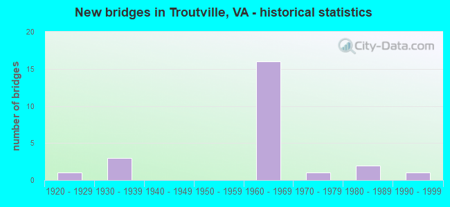
- New bridges - historical statistics
- 11920-1929
- 31930-1939
- 161960-1969
- 11970-1979
- 21980-1989
- 11990-1999


- Bridge Condition - Deck
- 7.1%Excellent
- 14.3%Very good
- 42.9%Good
- 28.6%Satisfactory
- 7.1%Fair

- Bridge Condition - Superstructure
- 7.1%Excellent
- 14.3%Very good
- 21.4%Good
- 28.6%Satisfactory
- 28.6%Fair

- Bridge Condition - Substructure
- 7.1%Very good
- 21.4%Good
- 50.0%Satisfactory
- 21.4%Fair

- Bridge Condition - Channel
- 36.4%Very good
- 63.6%Satisfactory
Find on map >> Show street view
Structure Number: 3162, Location: 0.04-Rte640N; .37-Rte640S (Lat: 37.453081, Lng: -79.832619), Route carried "on" structure: US 11, Year Built: 1986, Status: Open, Structure Length: 2.93m (9.61ft), Average Daily Traffic: 4,519 (year 2020), Truck Traffic: 5%, Average Future Daily Traffic: 5,095 (year 2040), Design Load: HS 20+Mod, Features Intersected: Mill Creek
Minimum Vertical Clearance: 30+ m (98+ ft), Kilometerpoint: 270.203, Lanes on structure: 4, Owner: State Highway Agency, Approaching Roadway Width: 14.0m (45.9ft), Skew: 4 degrees, Material/Design: Concrete, Design/Construction: Slab, Number Of Spans In Main Unit: 3, Length of Maximum Span: 9.8m (32.2ft), Curb-To-Curb Width: 17.9m (58.7ft), Out-to-Out Width: 18.9m (62.0ft)
Condition: Deck: Good, Superstructure: Good, Substructure: Good, Channel: Satisfactory, Operating Rating: 89.8 metric tons, Method Used To Determine Operating Rating: Load and Resistance Factor (LRFR), Inventory Rating: 77.1 metric tons, Method Used To Determine Inventory Rating: Load and Resistance Factor (LRFR), Structural Evaluation: Better than present minimum criteria, Deck Geometry: Somewhat better than minimum adequacy, Waterway Adequacy: Somewhat better than minimum adequacy, Approach Roadway Alignment: Equal to present desirable criteria, Length Of Structure Improvement: 2.96m (9.71ft), Designated Inspection Frequency: Every 24 months, Inspection Date: January 2022, Bridge Improvement Cost: $3,107,000, Roadway Improvement Cost: $1,087,000, Total Project Cost: $10,408,000 ( Estimate for 2022), Deck Structure Type: Concrete Cast-file-Place, Wearing Surface/Protective System: Deck Protection: Epoxy Coated Reinforcing
Find on map >> Show street view
Structure Number: 3163, Location: .03-Rte 651; .45-Rte 796 (Lat: 37.445689, Lng: -79.847064), Route carried "on" structure: US 11, Year Built: 1984, Status: Open, Structure Length: 1.14m (3.74ft), Average Daily Traffic: 4,519 (year 2020), Truck Traffic: 5%, Average Future Daily Traffic: 5,095 (year 2040), Design Load: HS 20+Mod, Features Intersected: Mill Creek
Minimum Vertical Clearance: 30+ m (98+ ft), Kilometerpoint: 268.676, Lanes on structure: 4, Base Highway Network: Yes, Owner: State Highway Agency, Approaching Roadway Width: 12.8m (42.0ft), Material/Design: Concrete, Design/Construction: Culvert, Number Of Spans In Main Unit: 4, Length of Maximum Span: 2.7m (8.9ft)
Condition: Channel: Satisfactory, Culverts: Satisfactory, Operating Rating: 54.4 metric tons, Method Used To Determine Operating Rating: Field evaluation and documented engineering judgment, Inventory Rating: 32.7 metric tons, Method Used To Determine Inventory Rating: Field evaluation and documented engineering judgment, Structural Evaluation: Equal to present minimum criteria, Waterway Adequacy: Somewhat better than minimum adequacy, Approach Roadway Alignment: Equal to present desirable criteria, Length Of Structure Improvement: 1.14m (3.74ft), Designated Inspection Frequency: Every 24 months, Inspection Date: March 2021, Bridge Improvement Cost: $863,000, Roadway Improvement Cost: $259,000, Total Project Cost: $2,762,000 ( Estimate for 2021)
Find on map >> Show street view
Structure Number: 3164, Location: 0.01 Rt 796; 1.57 Trvtvl (Lat: 37.442819, Lng: -79.854425), Route carried "on" structure: US 11, Year Built: 1924, Status: Open, Structure Length: 1.01m (3.31ft), Average Daily Traffic: 4,519 (year 2020), Truck Traffic: 5%, Average Future Daily Traffic: 5,095 (year 2040), Design Load: H 15, Features Intersected: Looney Mill Creek
Minimum Vertical Clearance: 30+ m (98+ ft), Kilometerpoint: 267.937, Lanes on structure: 4, Base Highway Network: Yes, Owner: State Highway Agency, Approaching Roadway Width: 12.2m (40.0ft), Skew: 4 degrees, Material/Design: Concrete, Design/Construction: Tee Beam, Number Of Spans In Main Unit: 1, Length of Maximum Span: 9.1m (29.9ft), Curb or Sidewalk Widths: Left: 0.5m (1.6ft), Right: 0.5m (1.6ft), Curb-To-Curb Width: 13.1m (43.0ft), Out-to-Out Width: 14.2m (46.6ft)
Condition: Deck: Satisfactory, Superstructure: Fair, Substructure: Satisfactory, Channel: Very good, Operating Rating: 39.0 metric tons, Method Used To Determine Operating Rating: Load and Resistance Factor (LRFR), Inventory Rating: 29.9 metric tons, Method Used To Determine Inventory Rating: Load and Resistance Factor (LRFR), Structural Evaluation: Somewhat better than minimum adequacy, Deck Geometry: High priority of replacement, Waterway Adequacy: Somewhat better than minimum adequacy, Approach Roadway Alignment: Equal to present desirable criteria, Length Of Structure Improvement: 1.01m (3.31ft), Designated Inspection Frequency: Every 24 months, Inspection Date: January 2021, Bridge Improvement Cost: $1,071,000, Roadway Improvement Cost: $375,000, Total Project Cost: $3,588,000 ( Estimate for 2020), Deck Structure Type: Concrete Cast-file-Place, Wearing Surface/Protective System: Wearing Surface: Bituminous
Find on map >> Show street view
Structure Number: 3174, Location: 1.37-N Trtv; 0.43-S Trtv (Lat: 37.409139, Lng: -79.885892), Route carried "on" structure: US 11, Year Built: 1932, Status: Open, Structure Length: 0.70m (2.30ft), Average Daily Traffic: 5,388 (year 2020), Truck Traffic: 1%, Average Future Daily Traffic: 5,927 (year 2040), Features Intersected: Buffalo Creek
Minimum Vertical Clearance: 30+ m (98+ ft), Kilometerpoint: 263.210, Lanes on structure: 4, Owner: State Highway Agency, Approaching Roadway Width: 12.5m (41.0ft), Skew: 3 degrees, Material/Design: Concrete, Design/Construction: Slab, Number Of Spans In Main Unit: 1, Length of Maximum Span: 6.3m (20.7ft), Curb or Sidewalk Widths: Left: 0.4m (1.3ft), Right: 0.4m (1.3ft), Curb-To-Curb Width: 13.4m (44.0ft), Out-to-Out Width: 14.3m (46.9ft)
Condition: Deck: Fair, Superstructure: Fair, Substructure: Fair, Channel: Very good, Operating Rating: 32.7 metric tons, Method Used To Determine Operating Rating: Field evaluation and documented engineering judgment, Inventory Rating: 32.7 metric tons, Method Used To Determine Inventory Rating: Field evaluation and documented engineering judgment, Structural Evaluation: Somewhat better than minimum adequacy, Deck Geometry: High priority of replacement, Waterway Adequacy: Somewhat better than minimum adequacy, Approach Roadway Alignment: Equal to present desirable criteria, Length Of Structure Improvement: 0.70m (2.30ft), Designated Inspection Frequency: Every 12 months, Inspection Date: Febuary 2022, Bridge Improvement Cost: $742,000, Roadway Improvement Cost: $260,000, Total Project Cost: $2,486,000 ( Estimate for 2022), Deck Structure Type: Concrete Cast-file-Place, Wearing Surface/Protective System: Wearing Surface: Bituminous
Find on map >> Show street view
Structure Number: 3244, Location: 5.08 RT 220; 0.95 RT 640 (Lat: 37.448864, Lng: -79.855361), Route carried "on" structure: Interstate 81, Year Built: 1964, Status: Open, Structure Length: 4.33m (14.21ft), Average Daily Traffic: 18,184 (year 2020), Truck Traffic: 32%, Average Future Daily Traffic: 25,458 (year 2040), Design Load: HS 20+Mod, Features Intersected: RTE 676
Minimum Vertical Clearance: 30+ m (98+ ft), Kilometerpoint: 250.328, Lanes on structure: 2, Lanes under structure: 2, Base Highway Network: Yes, Owner: State Highway Agency, Approaching Roadway Width: 11.0m (36.1ft), Skew: 3 degrees, Material/Design: Concrete, Design/Construction: Tee Beam, Number Of Spans In Main Unit: 3, Length of Maximum Span: 15.2m (49.9ft), Curb-To-Curb Width: 12.8m (42.0ft), Out-to-Out Width: 13.4m (44.0ft)
Condition: Deck: Good, Superstructure: Satisfactory, Substructure: Good, Operating Rating: 58.1 metric tons, Method Used To Determine Operating Rating: Load and Resistance Factor (LRFR), Inventory Rating: 44.5 metric tons, Method Used To Determine Inventory Rating: Load and Resistance Factor (LRFR), Structural Evaluation: Equal to present minimum criteria, Deck Geometry: Equal to present desirable criteria, Underclear: Somewhat better than minimum adequacy, Approach Roadway Alignment: Equal to present desirable criteria, Designated Inspection Frequency: Every 24 months, Inspection Date: May 2020, Deck Structure Type: Concrete Cast-file-Place, Wearing Surface/Protective System: Wearing Surface: Latex Concrete
Find on map >> Show street view
Structure Number: 3246, Location: 5.08 RT 220; 0.96 RT 640 (Lat: 37.449200, Lng: -79.855347), Route carried "on" structure: Interstate 81, Year Built: 1964, Status: Open, Structure Length: 4.01m (13.16ft), Average Daily Traffic: 17,592 (year 2020), Truck Traffic: 32%, Average Future Daily Traffic: 24,629 (year 2040), Design Load: HS 20+Mod, Features Intersected: RTE 676
Minimum Vertical Clearance: 30+ m (98+ ft), Kilometerpoint: 250.956, Lanes on structure: 2, Lanes under structure: 2, Base Highway Network: Yes, Owner: State Highway Agency, Approaching Roadway Width: 11.0m (36.1ft), Skew: 2 degrees, Material/Design: Concrete, Design/Construction: Tee Beam, Number Of Spans In Main Unit: 3, Length of Maximum Span: 13.7m (44.9ft), Curb-To-Curb Width: 12.8m (42.0ft), Out-to-Out Width: 13.4m (44.0ft)
Condition: Deck: Good, Superstructure: Satisfactory, Substructure: Satisfactory, Operating Rating: 53.5 metric tons, Method Used To Determine Operating Rating: Load and Resistance Factor (LRFR), Inventory Rating: 41.7 metric tons, Method Used To Determine Inventory Rating: Load and Resistance Factor (LRFR), Structural Evaluation: Equal to present minimum criteria, Deck Geometry: Equal to present desirable criteria, Underclear: Meets minimum limits, Approach Roadway Alignment: Equal to present desirable criteria, Designated Inspection Frequency: Every 24 months, Inspection Date: May 2020, Deck Structure Type: Concrete Cast-file-Place, Wearing Surface/Protective System: Wearing Surface: Latex Concrete
Find on map >> Show street view
Structure Number: 325, Location: 6.13- 220; 0.55- 650 (Lat: 37.457292, Lng: -79.839608), Route carried "on" structure: Interstate 81, Year Built: 1964, Year Reconstructed: 1990, Status: Open, Structure Length: 4.18m (13.71ft), Average Daily Traffic: 17,592 (year 2020), Truck Traffic: 32%, Average Future Daily Traffic: 24,629 (year 2040), Design Load: HS 20+Mod, Features Intersected: RTE 640
Minimum Vertical Clearance: 30+ m (98+ ft), Kilometerpoint: 252.677, Lanes on structure: 2, Lanes under structure: 2, Base Highway Network: Yes, Owner: State Highway Agency, Approaching Roadway Width: 11.6m (38.1ft), Skew: 1 degrees, Material/Design: Steel, Design/Construction: Stringer/Multi-beam, Number Of Spans In Main Unit: 3, Length of Maximum Span: 14.6m (47.9ft), Curb-To-Curb Width: 12.8m (42.0ft), Out-to-Out Width: 13.4m (44.0ft)
Condition: Deck: Satisfactory, Superstructure: Satisfactory, Substructure: Fair, Operating Rating: 65.3 metric tons, Method Used To Determine Operating Rating: Load and Resistance Factor (LRFR), Inventory Rating: 49.9 metric tons, Method Used To Determine Inventory Rating: Load and Resistance Factor (LRFR), Structural Evaluation: Somewhat better than minimum adequacy, Deck Geometry: Equal to present desirable criteria, Underclear: Somewhat better than minimum adequacy, Approach Roadway Alignment: Equal to present desirable criteria, Length Of Structure Improvement: 4.18m (13.71ft), Designated Inspection Frequency: Every 24 months, Inspection Date: Febuary 2022, Bridge Improvement Cost: $2,984,000, Roadway Improvement Cost: $1,343,000, Total Project Cost: $10,593,000 ( Estimate for 2021), Deck Structure Type: Concrete Cast-file-Place, Wearing Surface/Protective System: Wearing Surface: Latex Concrete, Deck Protection: Cathodic Protection
Find on map >> Show street view
Structure Number: 3252, Location: 3.72-220; 2.41-640 (Lat: 37.434278, Lng: -79.871242), Route carried "on" structure: Interstate 81, Year Built: 1964, Status: Open, Structure Length: 3.44m (11.29ft), Average Daily Traffic: 18,184 (year 2020), Truck Traffic: 32%, Average Future Daily Traffic: 25,458 (year 2040), Design Load: HS 20+Mod, Features Intersected: RTE 670
Minimum Vertical Clearance: 30+ m (98+ ft), Kilometerpoint: 248.172, Lanes on structure: 2, Lanes under structure: 2, Base Highway Network: Yes, Owner: State Highway Agency, Approaching Roadway Width: 11.0m (36.1ft), Skew: 1 degrees, Material/Design: Concrete, Design/Construction: Tee Beam, Number Of Spans In Main Unit: 3, Length of Maximum Span: 11.6m (38.1ft), Curb or Sidewalk Widths: Left: 0.3m (1.0ft), Right: 0.3m (1.0ft), Curb-To-Curb Width: 12.8m (42.0ft), Out-to-Out Width: 13.4m (44.0ft)
Condition: Deck: Satisfactory, Superstructure: Fair, Substructure: Fair, Operating Rating: 58.1 metric tons, Method Used To Determine Operating Rating: Load and Resistance Factor (LRFR), Inventory Rating: 44.5 metric tons, Method Used To Determine Inventory Rating: Load and Resistance Factor (LRFR), Structural Evaluation: Somewhat better than minimum adequacy, Deck Geometry: Equal to present desirable criteria, Underclear: Meets minimum limits, Approach Roadway Alignment: Equal to present desirable criteria, Length Of Structure Improvement: 3.44m (11.29ft), Designated Inspection Frequency: Every 24 months, Inspection Date: January 2022, Bridge Improvement Cost: $3,250,000, Roadway Improvement Cost: $1,987,000, Total Project Cost: $7,890,000 ( Estimate for 2022), Deck Structure Type: Concrete Cast-file-Place
Find on map >> Show street view
Structure Number: 3254, Location: 3.72-220; 2.41-640 (Lat: 37.434536, Lng: -79.871956), Route carried "on" structure: Interstate 81, Year Built: 1964, Status: Open, Structure Length: 3.44m (11.29ft), Average Daily Traffic: 17,592 (year 2020), Truck Traffic: 32%, Average Future Daily Traffic: 24,629 (year 2040), Design Load: HS 20+Mod, Features Intersected: Trinity Road
Minimum Vertical Clearance: 30+ m (98+ ft), Kilometerpoint: 248.800, Lanes on structure: 2, Lanes under structure: 2, Base Highway Network: Yes, Owner: State Highway Agency, Approaching Roadway Width: 11.0m (36.1ft), Material/Design: Concrete, Design/Construction: Tee Beam, Number Of Spans In Main Unit: 3, Length of Maximum Span: 11.6m (38.1ft), Curb or Sidewalk Widths: Left: 0.3m (1.0ft), Right: 0.3m (1.0ft), Curb-To-Curb Width: 12.8m (42.0ft), Out-to-Out Width: 13.4m (44.0ft)
Condition: Deck: Satisfactory, Superstructure: Fair, Substructure: Satisfactory, Operating Rating: 58.1 metric tons, Method Used To Determine Operating Rating: Load and Resistance Factor (LRFR), Inventory Rating: 44.5 metric tons, Method Used To Determine Inventory Rating: Load and Resistance Factor (LRFR), Structural Evaluation: Somewhat better than minimum adequacy, Deck Geometry: Equal to present desirable criteria, Underclear: Meets minimum limits, Approach Roadway Alignment: Equal to present desirable criteria, Length Of Structure Improvement: 3.44m (11.29ft), Designated Inspection Frequency: Every 24 months, Inspection Date: January 2022, Bridge Improvement Cost: $2,605,000, Roadway Improvement Cost: $1,172,000, Total Project Cost: $9,248,000 ( Estimate for 2022), Deck Structure Type: Concrete Cast-file-Place
Find on map >> Show street view
Structure Number: 3259, Location: 0.35-Rte640; 5.52-Rt 11 (Lat: 37.459133, Lng: -79.833189), Route carried "on" structure: Interstate 81, Year Built: 1964, Status: Open, Structure Length: 0.82m (2.69ft), Average Daily Traffic: 34,630 (year 2020), Truck Traffic: 32%, Average Future Daily Traffic: 47,705 (year 2040), Design Load: HS 20, Features Intersected: Branch of Mill Creek
Minimum Vertical Clearance: 30+ m (98+ ft), Kilometerpoint: 252.903, Lanes on structure: 4, Base Highway Network: Yes, Owner: State Highway Agency, Approaching Roadway Width: 21.9m (71.9ft), Skew: 4 degrees, Material/Design: Concrete, Design/Construction: Culvert, Number Of Spans In Main Unit: 3, Length of Maximum Span: 2.6m (8.5ft)
Condition: Channel: Satisfactory, Culverts: Satisfactory, Operating Rating: 54.4 metric tons, Method Used To Determine Operating Rating: Field evaluation and documented engineering judgment, Inventory Rating: 32.7 metric tons, Method Used To Determine Inventory Rating: Field evaluation and documented engineering judgment, Structural Evaluation: Equal to present minimum criteria, Waterway Adequacy: Better than present minimum criteria, Approach Roadway Alignment: Equal to present desirable criteria, Length Of Structure Improvement: 0.82m (2.69ft), Designated Inspection Frequency: Every 24 months, Inspection Date: March 2021, Bridge Improvement Cost: $697,000, Roadway Improvement Cost: $314,000, Total Project Cost: $2,475,000 ( Estimate for 2020)
Find on map >> Show street view
Structure Number: 3449, Location: 0.10-Rte11; 0.02-Rte716S (Lat: 37.417564, Lng: -79.873839), Route carried "on" structure: Alternate County highway 651, Year Built: 1969, Status: Open, Structure Length: 0.61m (2.00ft), Average Daily Traffic: 1,409 (year 2016), Average Future Daily Traffic: 1,578 (year 2040), Design Load: H 20, Features Intersected: Branch of Buffalo Creek
Minimum Vertical Clearance: 30+ m (98+ ft), Kilometerpoint: 7.477, Lanes on structure: 2, Owner: State Highway Agency, Approaching Roadway Width: 7.6m (24.9ft), Skew: 3 degrees, Material/Design: Steel, Design/Construction: Culvert, Number Of Spans In Main Unit: 2, Length of Maximum Span: 2.7m (8.9ft)
Condition: Channel: Satisfactory, Culverts: Satisfactory, Operating Rating: 44.5 metric tons, Method Used To Determine Operating Rating: Field evaluation and documented engineering judgment, Inventory Rating: 32.7 metric tons, Method Used To Determine Inventory Rating: Field evaluation and documented engineering judgment, Structural Evaluation: Equal to present minimum criteria, Waterway Adequacy: Equal to present minimum criteria, Approach Roadway Alignment: Equal to present minimum criteria, Length Of Structure Improvement: 0.61m (2.00ft), Designated Inspection Frequency: Every 24 months, Inspection Date: October 2020, Bridge Improvement Cost: $288,000, Roadway Improvement Cost: $72,000, Total Project Cost: $922,000 ( Estimate for 2020)
Find on map >> Show street view
Structure Number: 345, Location: 0.43 RT 11; 0.52 DEAD END (Lat: 37.420281, Lng: -79.882928), Route carried "on" structure: County highway 651, Year Built: 1964, Status: Open, Structure Length: 7.10m (23.29ft), Average Daily Traffic: 264 (year 2016), Average Future Daily Traffic: 296 (year 2040), Features Intersected: RTE I 81
Minimum Vertical Clearance: 30+ m (98+ ft), Kilometerpoint: 6.880, Lanes on structure: 2, Lanes under structure: 4, Owner: State Highway Agency, Approaching Roadway Width: 6.1m (20.0ft), Skew: 1 degrees, Material/Design: Steel, Design/Construction: Stringer/Multi-beam, Number Of Spans In Main Unit: 4, Length of Maximum Span: 24.4m (80.1ft), Curb or Sidewalk Widths: Left: 0.5m (1.6ft), Right: 0.5m (1.6ft), Curb-To-Curb Width: 7.3m (24.0ft), Out-to-Out Width: 8.8m (28.9ft)
Condition: Deck: Good, Superstructure: Satisfactory, Substructure: Satisfactory, Operating Rating: 51.7 metric tons, Method Used To Determine Operating Rating: Load and Resistance Factor (LRFR), Inventory Rating: 39.9 metric tons, Method Used To Determine Inventory Rating: Load and Resistance Factor (LRFR), Structural Evaluation: Equal to present minimum criteria, Deck Geometry: Somewhat better than minimum adequacy, Underclear: Equal to present minimum criteria, Approach Roadway Alignment: Equal to present desirable criteria, Length Of Structure Improvement: 7.10m (23.29ft), Designated Inspection Frequency: Every 24 months, Inspection Date: September 2020, Bridge Improvement Cost: $3,727,000, Roadway Improvement Cost: $932,000, Total Project Cost: $11,932,000 ( Estimate for 2019), Deck Structure Type: Concrete Cast-file-Place, Wearing Surface/Protective System: Wearing Surface: Epoxy Overlay
Find on map >> Show street view
Structure Number: 3487, Location: 0.10-Rte796; 1.00-Rte670 (Lat: 37.443758, Lng: -79.857950), Route carried "on" structure: County highway 676, Year Built: 1970, Status: Open, Structure Length: 1.04m (3.41ft), Average Daily Traffic: 341 (year 2016), Average Future Daily Traffic: 380 (year 2040), Features Intersected: Mill Creek
Minimum Vertical Clearance: 30+ m (98+ ft), Kilometerpoint: 1.599, Lanes on structure: 2, Owner: State Highway Agency, Approaching Roadway Width: 4.6m (15.1ft), Material/Design: Concrete, Design/Construction: Box Beam or Girders - Multiple, Number Of Spans In Main Unit: 1, Length of Maximum Span: 9.0m (29.5ft), Curb or Sidewalk Widths: Left: 0.1m (0.3ft), Right: 0.1m (0.3ft), Curb-To-Curb Width: 4.9m (16.1ft), Out-to-Out Width: 5.4m (17.7ft)
Condition: Deck: Excellent, Superstructure: Excellent, Substructure: Satisfactory, Channel: Satisfactory, Operating Rating: 70.8 metric tons, Method Used To Determine Operating Rating: Load and Resistance Factor (LRFR), Inventory Rating: 54.4 metric tons, Method Used To Determine Inventory Rating: Load and Resistance Factor (LRFR), Structural Evaluation: Equal to present minimum criteria, Deck Geometry: High priority of replacement, Waterway Adequacy: Somewhat better than minimum adequacy, Approach Roadway Alignment: Equal to present minimum criteria, Length Of Structure Improvement: 1.04m (3.41ft), Designated Inspection Frequency: Every 24 months, Inspection Date: October 2020, Bridge Improvement Cost: $498,000, Roadway Improvement Cost: $125,000, Total Project Cost: $1,595,000 ( Estimate for 2020), Deck Structure Type: Concrete Precast Panels, Wearing Surface/Protective System: Wearing Surface: Bituminous
Find on map >> Show street view
Structure Number: 3488, Location: 0.90-Rte670;0.20-Rte796 (Lat: 37.443097, Lng: -79.858831), Route carried "on" structure: County highway 676, Year Built: 1932, Status: Open, Structure Length: 1.07m (3.51ft), Average Daily Traffic: 341 (year 2016), Average Future Daily Traffic: 380 (year 2040), Features Intersected: Mill Creek
Minimum Vertical Clearance: 30+ m (98+ ft), Kilometerpoint: 1.438, Lanes on structure: 2, Owner: State Highway Agency, Approaching Roadway Width: 4.9m (16.1ft), Skew: 2 degrees, Material/Design: Steel, Design/Construction: Stringer/Multi-beam, Number Of Spans In Main Unit: 1, Length of Maximum Span: 8.5m (27.9ft), Curb or Sidewalk Widths: Left: 0.2m (0.7ft), Right: 0.2m (0.7ft), Curb-To-Curb Width: 5.5m (18.0ft), Out-to-Out Width: 5.8m (19.0ft)
Condition: Deck: Good, Superstructure: Good, Substructure: Satisfactory, Channel: Satisfactory, Operating Rating: 55.3 metric tons, Method Used To Determine Operating Rating: Load and Resistance Factor (LRFR), Inventory Rating: 42.6 metric tons, Method Used To Determine Inventory Rating: Load and Resistance Factor (LRFR), Structural Evaluation: Equal to present minimum criteria, Deck Geometry: High priority of corrective action, Waterway Adequacy: Somewhat better than minimum adequacy, Approach Roadway Alignment: Equal to present minimum criteria, Length Of Structure Improvement: 1.07m (3.51ft), Designated Inspection Frequency: Every 24 months, Inspection Date: May 2020, Bridge Improvement Cost: $513,000, Roadway Improvement Cost: $128,000, Total Project Cost: $1,642,000 ( Estimate for 2020), Deck Structure Type: Wood or Timber, Wearing Surface/Protective System: Wearing Surface: Bituminous, Membrane: Preformed Fabric
Find on map >> Show street view
Structure Number: 353, Location: 0.05-Rte11; 0.40-d. end (Lat: 37.448828, Lng: -79.842361), Route carried "on" structure: County highway 797, Year Built: 1932, Status: Open, Structure Length: 0.91m (2.99ft), Average Daily Traffic: 20 (year 2019), Average Future Daily Traffic: 25 (year 2040), Features Intersected: Mill Creek
Minimum Vertical Clearance: 30+ m (98+ ft), Kilometerpoint: 0.080, Lanes on structure: 1, Owner: State Highway Agency, Approaching Roadway Width: 3.2m (10.5ft), Material/Design: Steel, Design/Construction: Stringer/Multi-beam, Number Of Spans In Main Unit: 1, Length of Maximum Span: 8.2m (26.9ft), Curb or Sidewalk Widths: Left: 0.2m (0.7ft), Right: 0.2m (0.7ft), Curb-To-Curb Width: 4.5m (14.8ft), Out-to-Out Width: 4.8m (15.7ft)
Condition: Deck: Very good, Superstructure: Very good, Substructure: Very good, Channel: Very good, Operating Rating: 57.2 metric tons, Method Used To Determine Operating Rating: Load and Resistance Factor (LRFR), Inventory Rating: 43.5 metric tons, Method Used To Determine Inventory Rating: Load and Resistance Factor (LRFR), Structural Evaluation: Equal to present desirable criteria, Deck Geometry: Equal to present minimum criteria, Waterway Adequacy: Equal to present minimum criteria, Approach Roadway Alignment: High priority of corrective action, Length Of Structure Improvement: 0.91m (2.99ft), Designated Inspection Frequency: Every 24 months, Inspection Date: August 2020, Bridge Improvement Cost: $242,000, Roadway Improvement Cost: $36,000, Total Project Cost: $715,000 ( Estimate for 2020), Deck Structure Type: Wood or Timber, Wearing Surface/Protective System: Wearing Surface: Bituminous, Membrane: Preformed Fabric
Find on map >> Show street view
Structure Number: 3531, Location: 0.55-Rte640; 0.05-Rte11 (Lat: 37.450919, Lng: -79.837275), Route carried "on" structure: County highway 798, Year Built: 1969, Status: Open, Structure Length: 1.04m (3.41ft), Average Daily Traffic: 132 (year 2016), Average Future Daily Traffic: 193 (year 2040), Design Load: HL 93, Features Intersected: Mill Creek
Minimum Vertical Clearance: 30+ m (98+ ft), Kilometerpoint: 0.080, Lanes on structure: 2, Owner: State Highway Agency, Approaching Roadway Width: 4.3m (14.1ft), Skew: 1 degrees, Material/Design: Concrete, Design/Construction: Box Beam or Girders - Multiple, Number Of Spans In Main Unit: 1, Length of Maximum Span: 9.2m (30.2ft), Curb or Sidewalk Widths: Left: 0.1m (0.3ft), Right: 0.1m (0.3ft), Curb-To-Curb Width: 6.6m (21.7ft), Out-to-Out Width: 6.8m (22.3ft)
Condition: Deck: Very good, Superstructure: Very good, Substructure: Satisfactory, Channel: Very good, Operating Rating: 68.0 metric tons, Method Used To Determine Operating Rating: Load and Resistance Factor (LRFR), Inventory Rating: 52.6 metric tons, Method Used To Determine Inventory Rating: Load and Resistance Factor (LRFR), Structural Evaluation: Equal to present minimum criteria, Deck Geometry: Meets minimum limits, Waterway Adequacy: Meets minimum limits, Approach Roadway Alignment: Equal to present minimum criteria, Length Of Structure Improvement: 1.04m (3.41ft), Designated Inspection Frequency: Every 24 months, Inspection Date: October 2021, Bridge Improvement Cost: $449,000, Roadway Improvement Cost: $67,000, Total Project Cost: $1,324,000 ( Estimate for 2021), Wearing Surface/Protective System: Wearing Surface: Bituminous
Find on map >> Show street view
Structure Number: 25263, Location: 1.68-N Trout;0.12-S Trout (Lat: 37.405244, Lng: -79.888847), Route carried "on" structure: US 11, Year Built: 1998, Status: Open, Structure Length: 1.89m (6.20ft), Average Daily Traffic: 5,388 (year 2020), Truck Traffic: 1%, Average Future Daily Traffic: 5,927 (year 2040), Design Load: HS 20+Mod, Features Intersected: Buffalo Creek
Minimum Vertical Clearance: 30+ m (98+ ft), Kilometerpoint: 262.718, Lanes on structure: 4, Owner: State Highway Agency, Approaching Roadway Width: 12.8m (42.0ft), Skew: 4 degrees, Material/Design: Prestressed concrete, Design/Construction: Box Beam or Girders - Multiple, Number Of Spans In Main Unit: 2, Length of Maximum Span: 9.4m (30.8ft), Curb or Sidewalk Widths: Left: 0.4m (1.3ft), Right: 0.4m (1.3ft), Curb-To-Curb Width: 16.9m (55.4ft), Out-to-Out Width: 17.7m (58.1ft)
Condition: Deck: Good, Superstructure: Good, Substructure: Good, Channel: Satisfactory, Operating Rating: 89.8 metric tons, Method Used To Determine Operating Rating: Load and Resistance Factor (LRFR), Inventory Rating: 76.2 metric tons, Method Used To Determine Inventory Rating: Load and Resistance Factor (LRFR), Structural Evaluation: Better than present minimum criteria, Deck Geometry: Somewhat better than minimum adequacy, Waterway Adequacy: High priority of corrective action, Approach Roadway Alignment: Equal to present desirable criteria, Length Of Structure Improvement: 1.98m (6.50ft), Designated Inspection Frequency: Every 24 months, Inspection Date: January 2022, Bridge Improvement Cost: $2,123,000, Roadway Improvement Cost: $743,000, Total Project Cost: $7,006,000 ( Estimate for 2020), Wearing Surface/Protective System: Wearing Surface: Bituminous
Find on map >> Show street view
Structure Number: 3244, Location: 5.08 RT 220; 0.95 RT 640 (Lat: 37.448864, Lng: -79.855361), Route carried "under" structure: County highway 676, Year Built: 1964, Structure Length: 0. m, Average Daily Traffic: 300 (year 2004), Features Intersected: RTE 676, Facility Carried by Structure: NBL ROUTE 0081
Minimum Vertical Clearance: 4.88m (16.01ft), Kilometerpoint: 2.430, Lanes on structure: 2, Lanes under structure: 2, Material/Design: Concrete, Design/Construction: Tee Beam, Length of Maximum Span: 15.2m (49.9ft)
Find on map >> Show street view
Structure Number: 3246, Location: 5.08 RT 220; 0.96 RT 640 (Lat: 37.449200, Lng: -79.855347), Route carried "under" structure: County highway 676, Year Built: 1964, Structure Length: 0. m, Average Daily Traffic: 300 (year 2004), Features Intersected: RTE 676, Facility Carried by Structure: SBL ROUTE 0081
Minimum Vertical Clearance: 4.80m (15.75ft), Kilometerpoint: 2.462, Lanes on structure: 2, Lanes under structure: 2, Material/Design: Concrete, Design/Construction: Tee Beam, Length of Maximum Span: 13.7m (44.9ft)
Find on map >> Show street view
Structure Number: 3248, Location: 6.13 RT 220; 5.87 RT 11 (Lat: 37.456789, Lng: -79.838942), Route carried "under" structure: County highway 640, Year Built: 1964, Structure Length: 0. m, Average Daily Traffic: 2,500 (year 2016), Features Intersected: RTE 640, Facility Carried by Structure: NBL ROUTE 0081
Minimum Vertical Clearance: 4.67m (15.32ft), Kilometerpoint: 5.455, Lanes on structure: 2, Lanes under structure: 2, Material/Design: Steel, Design/Construction: Stringer/Multi-beam, Length of Maximum Span: 14.9m (48.9ft)
Find on map >> Show street view
Structure Number: 325, Location: 6.13- 220; 0.55- 650 (Lat: 37.457292, Lng: -79.839608), Route carried "under" structure: County highway 640, Year Built: 1964, Structure Length: 0. m, Average Daily Traffic: 1,038 (year 2004), Features Intersected: RTE 640, Facility Carried by Structure: SBL ROUTE 0081
Minimum Vertical Clearance: 4.67m (15.32ft), Kilometerpoint: 5.487, Lanes on structure: 2, Lanes under structure: 2, Material/Design: Steel, Design/Construction: Stringer/Multi-beam, Length of Maximum Span: 14.6m (47.9ft)
Find on map >> Show street view
Structure Number: 3252, Location: 3.72-220; 2.41-640 (Lat: 37.434278, Lng: -79.871242), Route carried "under" structure: County highway 670, Year Built: 1964, Structure Length: 0. m, Average Daily Traffic: 1,700 (year 2014), Features Intersected: RTE 670, Facility Carried by Structure: NBL ROUTE 0081
Minimum Vertical Clearance: 4.70m (15.42ft), Kilometerpoint: 1.416, Lanes on structure: 2, Lanes under structure: 2, Material/Design: Concrete, Design/Construction: Tee Beam, Length of Maximum Span: 11.6m (38.1ft)
Find on map >> Show street view
Structure Number: 3254, Location: 3.72-220; 2.41-640 (Lat: 37.434536, Lng: -79.871956), Route carried "under" structure: County highway 670, Year Built: 1964, Structure Length: 0. m, Average Daily Traffic: 1,700 (year 2014), Features Intersected: Trinity Road, Facility Carried by Structure: SBL ROUTE 0081
Minimum Vertical Clearance: 4.57m (14.99ft), Kilometerpoint: 1.609, Lanes on structure: 2, Lanes under structure: 2, Material/Design: Concrete, Design/Construction: Tee Beam, Length of Maximum Span: 11.6m (38.1ft)
Find on map >> Show street view
Structure Number: 345, Location: 0.43 RT 11; 0.52 DEAD END (Lat: 37.420281, Lng: -79.882928), Route carried "under" structure: Interstate 81, Year Built: 1964, Structure Length: 0. m, Average Daily Traffic: 39,000 (year 2018), Truck Traffic: 31%, Features Intersected: RTE I 81, Facility Carried by Structure: SUNSET AVE. 651
Minimum Vertical Clearance: 5.21m (17.09ft), Kilometerpoint: 9.043, Lanes on structure: 2, Lanes under structure: 4, Material/Design: Steel, Design/Construction: Stringer/Multi-beam, Length of Maximum Span: 24.4m (80.1ft)