Bridge Statistics for Trumann, Arkansas (AR)
Condition, Traffic, Stress, Structural Evaluation, Project Costs
- National Bridge Inventory (NBI) Statistics
- 33Number of bridges
- 279ft / 85.0mTotal length
- 126,854Total average daily traffic
- 6,296Total average daily truck traffic
- National Bridge Inventory (NBI) Registered Bridges for Trumann
- No street view available for this location
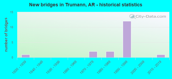
- New bridges - historical statistics
- 11930-1939
- 21970-1979
- 21980-1989
- 121990-1999
- 12010-2019


- Bridge Condition - Deck
- 6.7%Excellent
- 33.3%Very good
- 53.3%Good
- 6.7%Poor

- Bridge Condition - Superstructure
- 13.3%Very good
- 73.3%Good
- 6.7%Fair
- 6.7%Poor

- Bridge Condition - Substructure
- 13.3%Excellent
- 33.3%Very good
- 26.7%Good
- 13.3%Satisfactory
- 13.3%Fair

- Bridge Condition - Channel
- 8.3%Very good
- 66.7%Good
- 25.0%Satisfactory
Find on map >> Show street view
Structure Number: 5601, Location: 4.24MI E JCT SH 163 (Lat: 35.678150, Lng: -90.584839), Route carried "on" structure: State highway 69, Year Built: 1975, Status: Open, Structure Length: 6.16m (20.21ft), Average Daily Traffic: 1,666 (year 2018), Truck Traffic: 1%, Average Future Daily Traffic: 2,111 (year 2028), Design Load: HS 20, Features Intersected: DITCH NO 10
Minimum Vertical Clearance: 30+ m (98+ ft), Kilometerpoint: 6.759, Lanes on structure: 2, Owner: State Highway Agency, Approaching Roadway Width: 8.5m (27.9ft), Material/Design: Steel, Design/Construction: Stringer/Multi-beam, Number Of Spans In Main Unit: 5, Length of Maximum Span: 12.2m (40.0ft), Curb-To-Curb Width: 9.8m (32.2ft), Out-to-Out Width: 10.6m (34.8ft)
Condition: Deck: Good, Superstructure: Poor, Substructure: Satisfactory, Channel: Good, Operating Rating: 54.4 metric tons, Method Used To Determine Operating Rating: Load Factor (LF), Inventory Rating: 32.7 metric tons, Method Used To Determine Inventory Rating: Load Factor (LF), Structural Evaluation: Meets minimum limits, Deck Geometry: Somewhat better than minimum adequacy, Waterway Adequacy: Equal to present desirable criteria, Approach Roadway Alignment: Equal to present desirable criteria, Designated Inspection Frequency: Every 24 months, Critical Feature Inspection Frequency: Every 24 months, Inspection Date: Febuary 2022, Deck Structure Type: Concrete Cast-file-Place, Wearing Surface/Protective System: Wearing Surface: Epoxy Overlay
Find on map >> Show street view
Structure Number: 6338, Location: 3 1/4 MI N OF JUDD HILL (Lat: 35.646450, Lng: -90.518281), Route carried "on" structure: County highway 231, Year Built: 1991, Status: Open, Structure Length: 9.08m (29.79ft), Average Daily Traffic: 135 (year 1991), Truck Traffic: 1%, Average Future Daily Traffic: 93 (year 2011), Design Load: HS 20, Features Intersected: I-555-02- LM25.26
Minimum Vertical Clearance: 30+ m (98+ ft), Kilometerpoint: 2.060, Lanes on structure: 2, Lanes under structure: 4, Owner: State Highway Agency, Approaching Roadway Width: 8.5m (27.9ft), Skew: 2 degrees, Material/Design: Steel continuous, Design/Construction: Stringer/Multi-beam, Number Of Spans In Main Unit: 4, Length of Maximum Span: 29.9m (98.1ft), Curb-To-Curb Width: 8.5m (27.9ft), Out-to-Out Width: 9.4m (30.8ft)
Condition: Deck: Good, Superstructure: Good, Substructure: Very good, Operating Rating: 54.4 metric tons, Method Used To Determine Operating Rating: Load Factor (LF), Inventory Rating: 32.7 metric tons, Method Used To Determine Inventory Rating: Load Factor (LF), Structural Evaluation: Better than present minimum criteria, Deck Geometry: Equal to present minimum criteria, Underclear: Equal to present minimum criteria, Approach Roadway Alignment: Equal to present desirable criteria, Designated Inspection Frequency: Every 24 months, Critical Feature Inspection Frequency: Every 24 months, Inspection Date: November 2020, Deck Structure Type: Concrete Cast-file-Place, Wearing Surface/Protective System: Wearing Surface: Monolithic Concrete
Find on map >> Show street view
Structure Number: 6339, Location: 1 MI W & 3 1/2 M N JUDD H (Lat: 35.654281, Lng: -90.536069), Route carried "on" structure: County highway 230, Year Built: 1991, Status: Open, Structure Length: 9.08m (29.79ft), Average Daily Traffic: 540 (year 1987), Truck Traffic: 1%, Average Future Daily Traffic: 111 (year 2007), Design Load: HS 20, Features Intersected: I-555-02-LM26.40
Minimum Vertical Clearance: 30+ m (98+ ft), Kilometerpoint: 5.874, Lanes on structure: 2, Lanes under structure: 4, Owner: State Highway Agency, Approaching Roadway Width: 8.5m (27.9ft), Skew: 2 degrees, Material/Design: Steel continuous, Design/Construction: Stringer/Multi-beam, Number Of Spans In Main Unit: 4, Length of Maximum Span: 29.9m (98.1ft), Curb-To-Curb Width: 8.5m (27.9ft), Out-to-Out Width: 9.4m (30.8ft)
Condition: Deck: Good, Superstructure: Good, Substructure: Very good, Operating Rating: 54.4 metric tons, Method Used To Determine Operating Rating: Load Factor (LF), Inventory Rating: 32.7 metric tons, Method Used To Determine Inventory Rating: Load Factor (LF), Structural Evaluation: Better than present minimum criteria, Deck Geometry: Somewhat better than minimum adequacy, Underclear: Equal to present minimum criteria, Approach Roadway Alignment: Superior to present desirable criteria, Designated Inspection Frequency: Every 24 months, Critical Feature Inspection Frequency: Every 24 months, Inspection Date: November 2020, Deck Structure Type: Concrete Cast-file-Place, Wearing Surface/Protective System: Wearing Surface: Monolithic Concrete
Find on map >> Show street view
Structure Number: 18691, Location: .25 N SH 69 (Lat: 35.681731, Lng: -90.589089), Route carried "on" structure: County highway 224, Year Built: 1975, Status: Open, Structure Length: 4.42m (14.50ft), Average Daily Traffic: 57 (year 2018), Truck Traffic: 1%, Average Future Daily Traffic: 86 (year 2007), Features Intersected: LITTLE BAY DITCH
Minimum Vertical Clearance: 30+ m (98+ ft), Kilometerpoint: 0.338, Lanes on structure: 2, Owner: County Highway Agency, Approaching Roadway Width: 8.5m (27.9ft), Material/Design: Concrete, Design/Construction: Channel Beam, Number Of Spans In Main Unit: 7, Length of Maximum Span: 9.4m (30.8ft), Curb or Sidewalk Widths: Left: 0.2m (0.7ft), Right: 0.2m (0.7ft), Curb-To-Curb Width: 8.1m (26.6ft), Out-to-Out Width: 8.7m (28.5ft)
Condition: Deck: Good, Superstructure: Good, Substructure: Fair, Channel: Satisfactory, Operating Rating: 41.7 metric tons, Method Used To Determine Operating Rating: Load Factor (LF), Inventory Rating: 25.4 metric tons, Method Used To Determine Inventory Rating: Load Factor (LF), Structural Evaluation: Somewhat better than minimum adequacy, Deck Geometry: Equal to present minimum criteria, Waterway Adequacy: Superior to present desirable criteria, Approach Roadway Alignment: Equal to present desirable criteria, Designated Inspection Frequency: Every 24 months, Critical Feature Inspection Frequency: Every 24 months, Inspection Date: July 2020, Deck Structure Type: Concrete Precast Panels, Wearing Surface/Protective System: Wearing Surface: Monolithic Concrete
Find on map >> Show street view
Structure Number: 21517, Location: 5.90 MI S CRAIG CO LINE (Lat: 35.633239, Lng: -90.500600), Route carried "on" structure: State highway 463, Year Built: 1994, Status: Open, Structure Length: 0.94m (3.08ft), Average Daily Traffic: 2,488 (year 2018), Truck Traffic: 1%, Average Future Daily Traffic: 13 (year 2028), Features Intersected: DITCH
Minimum Vertical Clearance: 30+ m (98+ ft), Kilometerpoint: 9.495, Lanes on structure: 2, Owner: State Highway Agency, Approaching Roadway Width: 7.9m (25.9ft), Material/Design: Concrete, Design/Construction: Channel Beam, Number Of Spans In Main Unit: 1, Length of Maximum Span: 9.1m (29.9ft), Curb or Sidewalk Widths: Left: 0.3m (1.0ft), Right: 0.3m (1.0ft), Curb-To-Curb Width: 8.4m (27.6ft), Out-to-Out Width: 9.1m (29.9ft)
Condition: Deck: Good, Superstructure: Good, Substructure: Fair, Channel: Satisfactory, Operating Rating: 49.9 metric tons, Method Used To Determine Operating Rating: Load Factor (LF), Inventory Rating: 29.9 metric tons, Method Used To Determine Inventory Rating: Load Factor (LF), Structural Evaluation: Somewhat better than minimum adequacy, Deck Geometry: High priority of corrective action, Waterway Adequacy: Equal to present desirable criteria, Approach Roadway Alignment: Somewhat better than minimum adequacy, Designated Inspection Frequency: Every 24 months, Critical Feature Inspection Frequency: Every 24 months, Inspection Date: August 2020, Deck Structure Type: Concrete Precast Panels, Wearing Surface/Protective System: Wearing Surface: Monolithic Concrete
Find on map >> Show street view
Structure Number: 21686, Location: JCT CO RD 50&51 (Lat: 35.649119, Lng: -90.580389), Route carried "on" structure: County highway 50, Year Built: 1996, Status: Posted for load, Structure Length: 1.39m (4.56ft), Average Daily Traffic: 11 (year 2018), Truck Traffic: 1%, Average Future Daily Traffic: 22 (year 2007), Features Intersected: DITCH NO 11
Minimum Vertical Clearance: 30+ m (98+ ft), Kilometerpoint: 4.522, Lanes on structure: 1, Owner: County Highway Agency, Approaching Roadway Width: 5.5m (18.0ft), Material/Design: Wood or Timber, Design/Construction: Stringer/Multi-beam, Number Of Spans In Main Unit: 3, Length of Maximum Span: 4.6m (15.1ft), Curb-To-Curb Width: 4.9m (16.1ft), Out-to-Out Width: 4.9m (16.1ft)
Condition: Deck: Poor, Superstructure: Fair, Substructure: Satisfactory, Channel: Satisfactory, Operating Rating: 10.9 metric tons, Method Used To Determine Operating Rating: Allowable Stress (AS), Inventory Rating: 7.3 metric tons, Method Used To Determine Inventory Rating: Allowable Stress (AS), Structural Evaluation: High priority of corrective action, Deck Geometry: High priority of corrective action, Waterway Adequacy: Better than present minimum criteria, Approach Roadway Alignment: Somewhat better than minimum adequacy, Bridge Posting: Required (Relationship of Operating Rating to Maximum Legal Load: > 39.9% below), Designated Inspection Frequency: Every 24 months, Critical Feature Inspection Frequency: Every 24 months, Inspection Date: June 2021, Deck Structure Type: Wood or Timber, Wearing Surface/Protective System: Wearing Surface: Wood or Timber
Find on map >> Show street view
Structure Number: 21889, Location: .6 MI E SH #69 (Lat: 35.706056, Lng: -90.474347), Route carried "on" structure: County highway 751, Year Built: 1997, Status: Open, Structure Length: 3.66m (12.01ft), Average Daily Traffic: 606 (year 2018), Truck Traffic: 1%, Average Future Daily Traffic: 144 (year 2007), Features Intersected: DITCH #23
Minimum Vertical Clearance: 30+ m (98+ ft), Kilometerpoint: 0.032, Lanes on structure: 2, Owner: County Highway Agency, Approaching Roadway Width: 4.9m (16.1ft), Material/Design: Concrete, Design/Construction: Channel Beam, Number Of Spans In Main Unit: 4, Length of Maximum Span: 9.1m (29.9ft), Curb-To-Curb Width: 8.9m (29.2ft), Out-to-Out Width: 9.4m (30.8ft)
Condition: Deck: Good, Superstructure: Good, Substructure: Good, Channel: Good, Operating Rating: 49.9 metric tons, Method Used To Determine Operating Rating: Load Factor (LF), Inventory Rating: 29.9 metric tons, Method Used To Determine Inventory Rating: Load Factor (LF), Structural Evaluation: Better than present minimum criteria, Deck Geometry: Somewhat better than minimum adequacy, Waterway Adequacy: Equal to present desirable criteria, Approach Roadway Alignment: Somewhat better than minimum adequacy, Designated Inspection Frequency: Every 24 months, Critical Feature Inspection Frequency: Every 24 months, Inspection Date: June 2021, Deck Structure Type: Concrete Precast Panels, Wearing Surface/Protective System: Wearing Surface: Monolithic Concrete
Find on map >> Show street view
Structure Number: 22127, Location: 0.09 E J CR 267 & CR 266 (Lat: 35.620383, Lng: -90.472292), Route carried "on" structure: County highway 267, Year Built: 1999, Status: Open, Structure Length: 4.63m (15.19ft), Average Daily Traffic: 1,297 (year 2018), Truck Traffic: 1%, Average Future Daily Traffic: 22 (year 2007), Design Load: HS 20, Features Intersected: DITCH NO 35
Minimum Vertical Clearance: 30+ m (98+ ft), Kilometerpoint: 0.145, Lanes on structure: 2, Owner: County Highway Agency, Approaching Roadway Width: 7.6m (24.9ft), Material/Design: Prestressed concrete, Design/Construction: Slab, Number Of Spans In Main Unit: 3, Length of Maximum Span: 15.2m (49.9ft), Curb or Sidewalk Widths: Left: 0.3m (1.0ft), Right: 0.3m (1.0ft), Curb-To-Curb Width: 7.6m (24.9ft), Out-to-Out Width: 8.2m (26.9ft)
Condition: Deck: Very good, Superstructure: Good, Substructure: Good, Channel: Good, Operating Rating: 49.9 metric tons, Method Used To Determine Operating Rating: Load Factor (LF), Inventory Rating: 29.0 metric tons, Method Used To Determine Inventory Rating: Load Factor (LF), Structural Evaluation: Better than present minimum criteria, Deck Geometry: Meets minimum limits, Waterway Adequacy: Equal to present desirable criteria, Approach Roadway Alignment: Better than present minimum criteria, Designated Inspection Frequency: Every 24 months, Critical Feature Inspection Frequency: Every 24 months, Inspection Date: July 2021, Deck Structure Type: Concrete Precast Panels, Wearing Surface/Protective System: Wearing Surface: Monolithic Concrete
Find on map >> Show street view
Structure Number: 2374, Location: JCT 48 & 51 (Lat: 35.634711, Lng: -90.580689), Route carried "on" structure: County highway 48, Year Built: 2015, Status: Open, Structure Length: 1.52m (4.99ft), Average Daily Traffic: 435 (year 2018), Truck Traffic: 1%, Average Future Daily Traffic: 98 (year 2007), Features Intersected: Ditch No 11
Minimum Vertical Clearance: 30+ m (98+ ft), Kilometerpoint: 3.219, Lanes on structure: 2, Owner: County Highway Agency, Approaching Roadway Width: 5.5m (18.0ft), Material/Design: Steel, Design/Construction: Stringer/Multi-beam, Number Of Spans In Main Unit: 1, Length of Maximum Span: 14.9m (48.9ft), Curb-To-Curb Width: 7.3m (24.0ft), Out-to-Out Width: 7.3m (24.0ft)
Condition: Deck: Excellent, Superstructure: Good, Substructure: Excellent, Channel: Good, Operating Rating: 39.9 metric tons, Method Used To Determine Operating Rating: Load Factor (LF), Inventory Rating: 23.6 metric tons, Method Used To Determine Inventory Rating: Load Factor (LF), Structural Evaluation: Equal to present minimum criteria, Deck Geometry: Meets minimum limits, Waterway Adequacy: Better than present minimum criteria, Approach Roadway Alignment: Equal to present minimum criteria, Designated Inspection Frequency: Every 24 months, Critical Feature Inspection Frequency: Every 24 months, Inspection Date: October 2021, Deck Structure Type: Concrete Cast-file-Place, Wearing Surface/Protective System: Wearing Surface: Monolithic Concrete
Find on map >> Show street view
Structure Number: A6043, Location: E SH 463 &CORD 266 (Lat: 35.620211, Lng: -90.496750), Route carried "on" structure: Interstate 555, Year Built: 1984, Status: Open, Structure Length: 5.94m (19.49ft), Average Daily Traffic: 7,000 (year 2018), Truck Traffic: 1%, Average Future Daily Traffic: 6,830 (year 2028), Design Load: HS 20, Features Intersected: CR 266-C- DITCH 23
Minimum Vertical Clearance: 30+ m (98+ ft), Kilometerpoint: 36.951, Lanes on structure: 2, Lanes under structure: 2, Base Highway Network: Yes, Owner: State Highway Agency, Approaching Roadway Width: 12.2m (40.0ft), Material/Design: Steel continuous, Design/Construction: Stringer/Multi-beam, Number Of Spans In Main Unit: 3, Length of Maximum Span: 27.7m (90.9ft), Curb-To-Curb Width: 12.2m (40.0ft), Out-to-Out Width: 13.0m (42.7ft)
Condition: Deck: Very good, Superstructure: Good, Substructure: Very good, Channel: Good, Operating Rating: 54.4 metric tons, Method Used To Determine Operating Rating: Load Factor (LF), Inventory Rating: 32.7 metric tons, Method Used To Determine Inventory Rating: Load Factor (LF), Structural Evaluation: Better than present minimum criteria, Deck Geometry: Better than present minimum criteria, Underclear: High priority of corrective action, Waterway Adequacy: Equal to present desirable criteria, Approach Roadway Alignment: Equal to present desirable criteria, Designated Inspection Frequency: Every 24 months, Critical Feature Inspection Frequency: Every 24 months, Inspection Date: May 2020, Deck Structure Type: Concrete Cast-file-Place, Wearing Surface/Protective System: Wearing Surface: Epoxy Overlay
Find on map >> Show street view
Structure Number: A6337, Location: 2.5 MI S OF TRUMANN (Lat: 35.630211, Lng: -90.500511), Route carried "on" structure: Interstate 555, Year Built: 1992, Status: Open, Structure Length: 9.51m (31.20ft), Average Daily Traffic: 8,500 (year 2018), Truck Traffic: 1%, Average Future Daily Traffic: 6,830 (year 2028), Design Load: HS 20, Features Intersected: SH 463
Minimum Vertical Clearance: 30+ m (98+ ft), Kilometerpoint: 38.174, Lanes on structure: 2, Lanes under structure: 2, Base Highway Network: Yes, Owner: State Highway Agency, Approaching Roadway Width: 12.2m (40.0ft), Skew: 5 degrees, Material/Design: Steel continuous, Design/Construction: Stringer/Multi-beam, Number Of Spans In Main Unit: 3, Length of Maximum Span: 37.2m (122.0ft), Curb-To-Curb Width: 12.2m (40.0ft), Out-to-Out Width: 13.0m (42.7ft)
Condition: Deck: Very good, Superstructure: Good, Substructure: Good, Operating Rating: 50.8 metric tons, Method Used To Determine Operating Rating: Load Factor (LF), Inventory Rating: 29.9 metric tons, Method Used To Determine Inventory Rating: Load Factor (LF), Structural Evaluation: Better than present minimum criteria, Deck Geometry: Better than present minimum criteria, Underclear: Meets minimum limits, Approach Roadway Alignment: Equal to present desirable criteria, Designated Inspection Frequency: Every 24 months, Critical Feature Inspection Frequency: Every 24 months, Inspection Date: May 2020, Deck Structure Type: Concrete Cast-file-Place, Wearing Surface/Protective System: Wearing Surface: Epoxy Overlay
Find on map >> Show street view
Structure Number: A6399, Location: 1.65 MI W SH463 (Lat: 35.678011, Lng: -90.552900), Route carried "on" structure: Interstate 555, Year Built: 1993, Status: Open, Structure Length: 5.55m (18.21ft), Average Daily Traffic: 7,000 (year 2018), Truck Traffic: 1%, Average Future Daily Traffic: 8,071 (year 2028), Design Load: HS 20, Features Intersected: SH 69
Minimum Vertical Clearance: 30+ m (98+ ft), Kilometerpoint: 45.802, Lanes on structure: 2, Lanes under structure: 2, Base Highway Network: Yes, Owner: State Highway Agency, Approaching Roadway Width: 12.2m (40.0ft), Material/Design: Steel continuous, Design/Construction: Stringer/Multi-beam, Number Of Spans In Main Unit: 3, Length of Maximum Span: 27.4m (89.9ft), Curb-To-Curb Width: 12.2m (40.0ft), Out-to-Out Width: 13.0m (42.7ft)
Condition: Deck: Good, Superstructure: Very good, Substructure: Excellent, Operating Rating: 39.0 metric tons, Method Used To Determine Operating Rating: Load Factor (LF), Inventory Rating: 23.6 metric tons, Method Used To Determine Inventory Rating: Load Factor (LF), Structural Evaluation: Somewhat better than minimum adequacy, Deck Geometry: Better than present minimum criteria, Underclear: Superior to present desirable criteria, Approach Roadway Alignment: Equal to present desirable criteria, Designated Inspection Frequency: Every 24 months, Critical Feature Inspection Frequency: Every 24 months, Inspection Date: November 2020, Deck Structure Type: Concrete Cast-file-Place, Wearing Surface/Protective System: Wearing Surface: Epoxy Overlay
Find on map >> Show street view
Structure Number: B6043, Location: E SH 463 & CO RD 266 (Lat: 35.620211, Lng: -90.496469), Route carried "on" structure: Interstate 555, Year Built: 1984, Status: Open, Structure Length: 5.94m (19.49ft), Average Daily Traffic: 7,000 (year 2018), Truck Traffic: 24%, Average Future Daily Traffic: 6,830 (year 2028), Design Load: HS 20+Mod, Features Intersected: CR 266-C- DITCH 23
Minimum Vertical Clearance: 30+ m (98+ ft), Kilometerpoint: 36.951, Lanes on structure: 2, Lanes under structure: 2, Base Highway Network: Yes, Owner: State Highway Agency, Approaching Roadway Width: 12.2m (40.0ft), Material/Design: Steel continuous, Design/Construction: Stringer/Multi-beam, Number Of Spans In Main Unit: 3, Length of Maximum Span: 27.7m (90.9ft), Curb-To-Curb Width: 12.2m (40.0ft), Out-to-Out Width: 13.0m (42.7ft)
Condition: Deck: Very good, Superstructure: Good, Substructure: Very good, Channel: Very good, Operating Rating: 54.4 metric tons, Method Used To Determine Operating Rating: Load Factor (LF), Inventory Rating: 32.7 metric tons, Method Used To Determine Inventory Rating: Load Factor (LF), Structural Evaluation: Better than present minimum criteria, Deck Geometry: Better than present minimum criteria, Underclear: High priority of corrective action, Waterway Adequacy: Equal to present desirable criteria, Approach Roadway Alignment: Equal to present desirable criteria, Designated Inspection Frequency: Every 24 months, Critical Feature Inspection Frequency: Every 24 months, Inspection Date: May 2020, Deck Structure Type: Concrete Cast-file-Place, Wearing Surface/Protective System: Wearing Surface: Epoxy Overlay
Find on map >> Show street view
Structure Number: B6337, Location: 2.5 MI S AT TRUMANN (Lat: 35.630600, Lng: -90.500511), Route carried "on" structure: Interstate 555, Year Built: 1992, Status: Open, Structure Length: 9.51m (31.20ft), Average Daily Traffic: 8,500 (year 2018), Truck Traffic: 24%, Average Future Daily Traffic: 6,830 (year 2028), Design Load: HS 20, Features Intersected: SH 463
Minimum Vertical Clearance: 30+ m (98+ ft), Kilometerpoint: 38.190, Lanes on structure: 2, Lanes under structure: 2, Base Highway Network: Yes, Owner: State Highway Agency, Approaching Roadway Width: 12.2m (40.0ft), Skew: 5 degrees, Material/Design: Steel continuous, Design/Construction: Stringer/Multi-beam, Number Of Spans In Main Unit: 3, Length of Maximum Span: 37.2m (122.0ft), Curb-To-Curb Width: 12.2m (40.0ft), Out-to-Out Width: 13.0m (42.7ft)
Condition: Deck: Very good, Superstructure: Good, Substructure: Good, Operating Rating: 50.8 metric tons, Method Used To Determine Operating Rating: Load Factor (LF), Inventory Rating: 29.9 metric tons, Method Used To Determine Inventory Rating: Load Factor (LF), Structural Evaluation: Better than present minimum criteria, Deck Geometry: Better than present minimum criteria, Underclear: Meets minimum limits, Approach Roadway Alignment: Equal to present desirable criteria, Designated Inspection Frequency: Every 24 months, Critical Feature Inspection Frequency: Every 24 months, Inspection Date: May 2020, Deck Structure Type: Concrete Cast-file-Place, Wearing Surface/Protective System: Wearing Surface: Epoxy Overlay
Find on map >> Show street view
Structure Number: B6399, Location: 1.63 MI W SH 463 (Lat: 35.678011, Lng: -90.552619), Route carried "on" structure: Interstate 555, Year Built: 1993, Status: Open, Structure Length: 5.55m (18.21ft), Average Daily Traffic: 7,000 (year 2018), Truck Traffic: 22%, Average Future Daily Traffic: 8,071 (year 2028), Design Load: HS 20, Features Intersected: SH 69
Minimum Vertical Clearance: 30+ m (98+ ft), Kilometerpoint: 45.802, Lanes on structure: 2, Lanes under structure: 2, Owner: State Highway Agency, Approaching Roadway Width: 12.2m (40.0ft), Material/Design: Steel continuous, Design/Construction: Stringer/Multi-beam, Number Of Spans In Main Unit: 3, Length of Maximum Span: 27.4m (89.9ft), Curb-To-Curb Width: 12.2m (40.0ft), Out-to-Out Width: 13.0m (42.7ft)
Condition: Deck: Good, Superstructure: Very good, Substructure: Very good, Operating Rating: 38.1 metric tons, Method Used To Determine Operating Rating: Load Factor (LF), Inventory Rating: 22.7 metric tons, Method Used To Determine Inventory Rating: Load Factor (LF), Structural Evaluation: Somewhat better than minimum adequacy, Deck Geometry: Better than present minimum criteria, Underclear: Better than present minimum criteria, Approach Roadway Alignment: Equal to present desirable criteria, Designated Inspection Frequency: Every 24 months, Critical Feature Inspection Frequency: Every 24 months, Inspection Date: November 2020, Deck Structure Type: Concrete Cast-file-Place, Wearing Surface/Protective System: Wearing Surface: Epoxy Overlay
Find on map >> Show street view
Structure Number: M1139, Location: 1.0 M N OF SH 69 (Lat: 35.693100, Lng: -90.533839), Route carried "on" structure: State highway 463, Year Built: 1937, Status: Open, Structure Length: 0.73m (2.40ft), Average Daily Traffic: 3,586 (year 2018), Truck Traffic: 1%, Average Future Daily Traffic: 4,719 (year 2028), Design Load: H 15, Features Intersected: DITCH
Minimum Vertical Clearance: 30+ m (98+ ft), Kilometerpoint: 1.642, Lanes on structure: 2, Owner: State Highway Agency, Approaching Roadway Width: 11.0m (36.1ft), Skew: 3 degrees, Material/Design: Concrete, Design/Construction: Culvert, Number Of Spans In Main Unit: 2, Length of Maximum Span: 3.7m (12.1ft)
Condition: Channel: Good, Culverts: Good, Operating Rating: 39.9 metric tons, Method Used To Determine Operating Rating: Load Factor (LF), Inventory Rating: 23.6 metric tons, Method Used To Determine Inventory Rating: Load Factor (LF), Structural Evaluation: Equal to present minimum criteria, Waterway Adequacy: Equal to present desirable criteria, Approach Roadway Alignment: Equal to present desirable criteria, Designated Inspection Frequency: Every 24 months, Critical Feature Inspection Frequency: Every 24 months, Inspection Date: May 2020
Find on map >> Show street view
Structure Number: X0826, Location: W OF JCT 69 & US 63 (Lat: 35.678239, Lng: -90.554711), Route carried "on" structure: State highway 69, Year Built: 1991, Status: Open, Structure Length: 0.67m (2.20ft), Average Daily Traffic: 6,302 (year 2018), Truck Traffic: 1%, Average Future Daily Traffic: 2,111 (year 2028), Design Load: H 20, Features Intersected: CREEK
Minimum Vertical Clearance: 30+ m (98+ ft), Kilometerpoint: 9.479, Lanes on structure: 2, Owner: State Highway Agency, Approaching Roadway Width: 8.5m (27.9ft), Material/Design: Concrete, Design/Construction: Culvert, Number Of Spans In Main Unit: 3, Length of Maximum Span: 2.1m (6.9ft)
Condition: Channel: Good, Culverts: Good, Operating Rating: 27.2 metric tons, Method Used To Determine Operating Rating: Load Factor (LF), Inventory Rating: 16.3 metric tons, Method Used To Determine Inventory Rating: Load Factor (LF), Structural Evaluation: Meets minimum limits, Waterway Adequacy: Superior to present desirable criteria, Approach Roadway Alignment: Equal to present desirable criteria, Designated Inspection Frequency: Every 24 months, Critical Feature Inspection Frequency: Every 24 months, Inspection Date: August 2020
Find on map >> Show street view
Structure Number: X0842, Location: 1 MI N OF SH 69 (Lat: 35.692669, Lng: -90.552939), Route carried "on" structure: Interstate 555, Year Built: 1992, Status: Open, Structure Length: 0.76m (2.49ft), Average Daily Traffic: 14,000 (year 2018), Truck Traffic: 1%, Average Future Daily Traffic: 16,700 (year 2038), Design Load: H 20, Features Intersected: DITCH
Minimum Vertical Clearance: 30+ m (98+ ft), Kilometerpoint: 47.443, Lanes on structure: 4, Base Highway Network: Yes (Inventory Route: 630, Subroute: 1), Owner: State Highway Agency, Approaching Roadway Width: 24.4m (80.1ft), Skew: 11 degrees, Material/Design: Concrete, Design/Construction: Culvert, Number Of Spans In Main Unit: 3, Length of Maximum Span: 2.4m (7.9ft)
Condition: Channel: Good, Culverts: Good, Operating Rating: 29.9 metric tons, Method Used To Determine Operating Rating: Load Factor (LF), Inventory Rating: 18.1 metric tons, Method Used To Determine Inventory Rating: Load Factor (LF), Structural Evaluation: Meets minimum limits, Waterway Adequacy: Superior to present desirable criteria, Approach Roadway Alignment: Superior to present desirable criteria, Designated Inspection Frequency: Every 24 months, Critical Feature Inspection Frequency: Every 24 months, Inspection Date: January 2022
Find on map >> Show street view
Structure Number: 6338, Location: 3 1/4 MI N OF JUDD HILL (Lat: 35.646450, Lng: -90.518281), Route carried "under" structure: Interstate 555, Structure Length: 0. m, Average Daily Traffic: 5,000 (year 2014), Truck Traffic: 1%, Features Intersected: I555-02- LM25.26, Facility Carried by Structure: CR 231 SEC C
Minimum Vertical Clearance: 5.19m (17.03ft), Kilometerpoint: 40.652, Length of Maximum Span: 0.0m
Find on map >> Show street view
Structure Number: 6338, Location: 3 1/4 MI N OF JUDD HILL (Lat: 35.646450, Lng: -90.518281), Route carried "under" structure: Interstate 555, Structure Length: 0. m, Average Daily Traffic: 5,000 (year 2014), Truck Traffic: 1%, Features Intersected: I-555-02-LM 25.26, Facility Carried by Structure: CR 231 SEC C
Minimum Vertical Clearance: 5.23m (17.16ft), Kilometerpoint: 40.652, Length of Maximum Span: 0.0m
Find on map >> Show street view
Structure Number: 6339, Location: 1 MI W & 3 1/2 M N JUDD H (Lat: 35.654281, Lng: -90.536069), Route carried "under" structure: Interstate 555, Structure Length: 0. m, Average Daily Traffic: 5,000 (year 2014), Truck Traffic: 1%, Features Intersected: I-555-02-LM26.40, Facility Carried by Structure: CR 230 SEC C
Minimum Vertical Clearance: 5.10m (16.73ft), Kilometerpoint: 42.487, Length of Maximum Span: 0.0m
Find on map >> Show street view
Structure Number: 6339, Location: 1 MI W & 3 1/2 M N JUDD H (Lat: 35.654281, Lng: -90.536069), Route carried "under" structure: Interstate 555, Structure Length: 0. m, Average Daily Traffic: 5,000 (year 2014), Truck Traffic: 1%, Features Intersected: I-555-02-LM26.40, Facility Carried by Structure: CR 230 SEC C
Minimum Vertical Clearance: 5.11m (16.77ft), Kilometerpoint: 42.487, Length of Maximum Span: 0.0m
Find on map >> Show street view
Structure Number: 7046, Location: .82 Mi E of Hwy 463 (Lat: 35.678300, Lng: -90.510133), Route carried "under" structure: State highway 69, Structure Length: 0. m, Average Daily Traffic: 4,300 (year 2014), Truck Traffic: 1%, Features Intersected: SH 69-07, Facility Carried by Structure: Burlington N R/R
Minimum Vertical Clearance: 2.92m (9.58ft), Kilometerpoint: 1.320, Length of Maximum Span: 0.0m
Find on map >> Show street view
Structure Number: 18869, Location: NANCE LANE (Lat: 35.690650, Lng: -90.517583), Route carried "under" structure: County highway 720, Structure Length: 0. m, Average Daily Traffic: 28 (year 1983), Features Intersected: CR 720-C, Facility Carried by Structure: SL SF RR- C
Minimum Vertical Clearance: 2.65m (8.69ft), Kilometerpoint: 0.306, Length of Maximum Span: 0.0m
Find on map >> Show street view
Structure Number: 19318, Location: W Carlson in Truman (Lat: 35.671381, Lng: -90.505800), Route carried "under" structure: City street 9130, Structure Length: 0. m, Average Daily Traffic: 673 (year 1983), Truck Traffic: 1%, Features Intersected: EAST CARLSON, Facility Carried by Structure: BURLINGTON NOR-C
Minimum Vertical Clearance: 3.16m (10.37ft), Kilometerpoint: 1.062, Length of Maximum Span: 0.0m
Find on map >> Show street view
Structure Number: 2053, Location: SH 463 & Cedar St. (Lat: 35.675161, Lng: -90.521831), Route carried "under" structure: State highway 463, Structure Length: 0. m, Average Daily Traffic: 7,300 (year 2014), Truck Traffic: 1%, Features Intersected: SH 463-02- LM 2.42, Facility Carried by Structure: CEDAR ST-PED OVERP
Minimum Vertical Clearance: 4.91m (16.11ft), Kilometerpoint: 3.895, Length of Maximum Span: 0.0m
Find on map >> Show street view
Structure Number: A6043, Location: E SH 463 &CORD 266 (Lat: 35.620211, Lng: -90.496750), Route carried "under" structure: County highway 266, Structure Length: 0. m, Average Daily Traffic: 10 (year 1986), Truck Traffic: 1%, Features Intersected: CR 266-C- DITCH 23, Facility Carried by Structure: I-555-02SB-LM22.96
Minimum Vertical Clearance: 4.66m (15.29ft), Kilometerpoint: 0.483, Length of Maximum Span: 0.0m
Find on map >> Show street view
Structure Number: A6337, Location: 2.5 MI S OF TRUMANN (Lat: 35.630211, Lng: -90.500511), Route carried "under" structure: State highway 463, Structure Length: 0. m, Average Daily Traffic: 660 (year 2014), Truck Traffic: 1%, Features Intersected: SH 463, Facility Carried by Structure: I-555-02SB-LM23.72
Minimum Vertical Clearance: 5.15m (16.90ft), Kilometerpoint: 9.753, Length of Maximum Span: 0.0m
Find on map >> Show street view
Structure Number: A6399, Location: 1.65 MI W SH463 (Lat: 35.678011, Lng: -90.552900), Route carried "under" structure: State highway 69, Structure Length: 0. m, Average Daily Traffic: 7,300 (year 2014), Truck Traffic: 1%, Features Intersected: SH 69, Facility Carried by Structure: I-555SB-02-LM 28.4
Minimum Vertical Clearance: 5.19m (17.03ft), Kilometerpoint: 9.671, Length of Maximum Span: 0.0m
Find on map >> Show street view
Structure Number: B6043, Location: E SH 463 & CO RD 266 (Lat: 35.620211, Lng: -90.496469), Route carried "under" structure: County highway 266, Structure Length: 0. m, Average Daily Traffic: 10 (year 1986), Truck Traffic: 1%, Features Intersected: CR 266-C- DITCH 23, Facility Carried by Structure: I-555-02NB-LM22.96
Minimum Vertical Clearance: 4.72m (15.49ft), Kilometerpoint: 0.499, Length of Maximum Span: 0.0m
Find on map >> Show street view
Structure Number: B6337, Location: 2.5 MI S AT TRUMANN (Lat: 35.630600, Lng: -90.500511), Route carried "under" structure: State highway 463, Structure Length: 0. m, Average Daily Traffic: 2,400 (year 2014), Truck Traffic: 1%, Features Intersected: SH 463, Facility Carried by Structure: I-555-02NB-LM23.73
Minimum Vertical Clearance: 5.21m (17.09ft), Kilometerpoint: 9.640, Length of Maximum Span: 0.0m
Find on map >> Show street view
Structure Number: B6399, Location: 1.63 MI W SH 463 (Lat: 35.678011, Lng: -90.552619), Route carried "under" structure: State highway 69, Structure Length: 0. m, Average Daily Traffic: 7,300 (year 2014), Truck Traffic: 1%, Features Intersected: SH 69, Facility Carried by Structure: I-555NB-02-LM28.46
Minimum Vertical Clearance: 5.21m (17.09ft), Kilometerpoint: 9.656, Length of Maximum Span: 0.0m
Find on map >> Show street view
Structure Number: M3311, Location: .19 MI NE JCT US 63 (Lat: 35.658911, Lng: -90.498350), Route carried "under" structure: Spur State highway 69, Structure Length: 0. m, Average Daily Traffic: 750 (year 2014), Truck Traffic: 1%, Features Intersected: SH 69-07S-LM 1.52, Facility Carried by Structure: Burl. North. RR
Minimum Vertical Clearance: 3.84m (12.60ft), Kilometerpoint: 2.446, Length of Maximum Span: 0.0m