Bridge Statistics for Turrell, Arkansas (AR)
Condition, Traffic, Stress, Structural Evaluation, Project Costs
- National Bridge Inventory (NBI) Statistics
- 31Number of bridges
- 331ft / 101mTotal length
- $5,917,000Total costs
- 166,955Total average daily traffic
- 2,795Total average daily truck traffic
- National Bridge Inventory (NBI) Registered Bridges for Turrell
- No street view available for this location
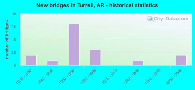
- New bridges - historical statistics
- 21930-1939
- 11940-1949
- 81950-1959
- 31960-1969
- 11980-1989
- 22000-2009


- Bridge Condition - Deck
- 6.3%Very good
- 62.5%Good
- 31.3%Satisfactory

- Bridge Condition - Superstructure
- 6.3%Very good
- 68.8%Good
- 18.8%Satisfactory
- 6.3%Fair

- Bridge Condition - Substructure
- 6.3%Very good
- 68.8%Good
- 6.3%Satisfactory
- 6.3%Fair
- 12.5%Poor

- Bridge Condition - Channel
- 28.6%Very good
- 28.6%Good
- 14.3%Satisfactory
- 21.4%Fair
- 7.1%Poor
Find on map >> Show street view
Structure Number: 2003, Location: Jct Sh 77 & 42 (Lat: 35.364619, Lng: -90.254697), Route carried "on" structure: State highway 77, Year Built: 1939, Status: Open, Structure Length: 6.45m (21.16ft), Average Daily Traffic: 670 (year 2018), Truck Traffic: 1%, Average Future Daily Traffic: 803 (year 2028), Design Load: H 15, Features Intersected: Big Creek
Minimum Vertical Clearance: 30+ m (98+ ft), Kilometerpoint: 3.090, Lanes on structure: 2, Owner: State Highway Agency, Approaching Roadway Width: 7.0m (23.0ft), Material/Design: Concrete, Design/Construction: Tee Beam, Number Of Spans In Main Unit: 7, Length of Maximum Span: 9.1m (29.9ft), Curb or Sidewalk Widths: Left: 0.1m (0.3ft), Right: 0.1m (0.3ft), Curb-To-Curb Width: 8.3m (27.2ft), Out-to-Out Width: 9.1m (29.9ft)
Condition: Deck: Good, Superstructure: Satisfactory, Substructure: Good, Channel: Satisfactory, Operating Rating: 53.5 metric tons, Method Used To Determine Operating Rating: Load Factor (LF), Inventory Rating: 32.7 metric tons, Method Used To Determine Inventory Rating: Load Factor (LF), Structural Evaluation: Equal to present minimum criteria, Deck Geometry: Somewhat better than minimum adequacy, Waterway Adequacy: Equal to present desirable criteria, Approach Roadway Alignment: Equal to present desirable criteria, Designated Inspection Frequency: Every 24 months, Critical Feature Inspection Frequency: Every 24 months, Inspection Date: April 2020, Deck Structure Type: Concrete Cast-file-Place, Wearing Surface/Protective System: Wearing Surface: Bituminous
Find on map >> Show street view
Structure Number: 2809, Location: 1.0 Mi S Jct Of Sh 42 (Lat: 35.351869, Lng: -90.275228), Route carried "on" structure: Interstate 55, Year Built: 1956, Year Reconstructed: 1975, Status: Open, Structure Length: 4.94m (16.21ft), Average Daily Traffic: 28,939 (year 2018), Truck Traffic: 1%, Average Future Daily Traffic: 17,304 (year 2028), Design Load: HS 20, Features Intersected: Big Creek
Minimum Vertical Clearance: 30+ m (98+ ft), Kilometerpoint: 33.072, Lanes on structure: 2, Base Highway Network: Yes, Owner: State Highway Agency, Approaching Roadway Width: 11.6m (38.1ft), Material/Design: Concrete continuous, Design/Construction: Slab, Number Of Spans In Main Unit: 6, Length of Maximum Span: 9.1m (29.9ft), Curb or Sidewalk Widths: Left: 0.2m (0.7ft), Right: 0.2m (0.7ft), Curb-To-Curb Width: 11.9m (39.0ft), Out-to-Out Width: 12.9m (42.3ft)
Condition: Deck: Good, Superstructure: Good, Substructure: Good, Channel: Very good, Operating Rating: 54.4 metric tons, Method Used To Determine Operating Rating: Load Factor (LF), Inventory Rating: 32.7 metric tons, Method Used To Determine Inventory Rating: Load Factor (LF), Structural Evaluation: Better than present minimum criteria, Deck Geometry: Equal to present minimum criteria, Waterway Adequacy: Equal to present desirable criteria, Approach Roadway Alignment: Equal to present desirable criteria, Designated Inspection Frequency: Every 24 months, Critical Feature Inspection Frequency: Every 24 months, Inspection Date: April 2020, Deck Structure Type: Concrete Cast-file-Place, Wearing Surface/Protective System: Wearing Surface: Epoxy Overlay
Find on map >> Show street view
Structure Number: 3138, Location: I-55 & Sh 42 (Lat: 35.365581, Lng: -90.280350), Route carried "on" structure: State highway 42, Year Built: 1958, Year Reconstructed: 1981, Status: Open, Structure Length: 9.82m (32.22ft), Average Daily Traffic: 740 (year 2018), Truck Traffic: 9%, Average Future Daily Traffic: 1,051 (year 2028), Design Load: H 20, Features Intersected: I-55/Sec-11/L-21.50
Minimum Vertical Clearance: 30+ m (98+ ft), Kilometerpoint: 12.472, Lanes on structure: 2, Lanes under structure: 8, Owner: State Highway Agency, Approaching Roadway Width: 9.8m (32.2ft), Material/Design: Steel, Design/Construction: Stringer/Multi-beam, Number Of Spans In Main Unit: 6, Length of Maximum Span: 18.3m (60.0ft), Curb-To-Curb Width: 8.5m (27.9ft), Out-to-Out Width: 9.5m (31.2ft)
Condition: Deck: Good, Superstructure: Good, Substructure: Fair, Operating Rating: 50.8 metric tons, Method Used To Determine Operating Rating: Load Factor (LF), Inventory Rating: 30.8 metric tons, Method Used To Determine Inventory Rating: Load Factor (LF), Structural Evaluation: Somewhat better than minimum adequacy, Deck Geometry: Somewhat better than minimum adequacy, Underclear: High priority of corrective action, Approach Roadway Alignment: Equal to present desirable criteria, Designated Inspection Frequency: Every 24 months, Critical Feature Inspection Frequency: Every 24 months, Inspection Date: Febuary 2022, Deck Structure Type: Concrete Cast-file-Place, Wearing Surface/Protective System: Wearing Surface: Monolithic Concrete
Find on map >> Show street view
Structure Number: 5244, Location: .20 Mi West Of Jct I-55 (Lat: 35.365608, Lng: -90.286939), Route carried "on" structure: State highway 42, Year Built: 1969, Status: Open, Structure Length: 5.24m (17.19ft), Average Daily Traffic: 740 (year 2018), Truck Traffic: 9%, Average Future Daily Traffic: 1,051 (year 2028), Design Load: HS 20, Features Intersected: Big Creek
Minimum Vertical Clearance: 30+ m (98+ ft), Kilometerpoint: 11.893, Lanes on structure: 2, Owner: State Highway Agency, Approaching Roadway Width: 7.3m (24.0ft), Skew: 1 degrees, Material/Design: Steel, Design/Construction: Stringer/Multi-beam, Number Of Spans In Main Unit: 1, Number Of Approach Spans: 4, Length of Maximum Span: 12.2m (40.0ft), Curb or Sidewalk Widths: Left: 0.1m (0.3ft), Right: 0.1m (0.3ft), Curb-To-Curb Width: 8.5m (27.9ft), Out-to-Out Width: 9.7m (31.8ft)
Condition: Deck: Satisfactory, Superstructure: Good, Substructure: Good, Channel: Good, Operating Rating: 48.1 metric tons, Method Used To Determine Operating Rating: Load Factor (LF), Inventory Rating: 29.0 metric tons, Method Used To Determine Inventory Rating: Load Factor (LF), Structural Evaluation: Better than present minimum criteria, Deck Geometry: Somewhat better than minimum adequacy, Waterway Adequacy: Equal to present desirable criteria, Approach Roadway Alignment: Equal to present desirable criteria, Designated Inspection Frequency: Every 24 months, Critical Feature Inspection Frequency: Every 24 months, Inspection Date: April 2020, Deck Structure Type: Concrete Cast-file-Place, Wearing Surface/Protective System: Wearing Surface: Monolithic Concrete
Find on map >> Show street view
Structure Number: 6998, Location: 3.6 Mi So Poinsett Co Ln (Lat: 35.391769, Lng: -90.273064), Route carried "on" structure: Interstate 555, Year Built: 2006, Status: Open, Structure Length: 8.60m (28.22ft), Average Daily Traffic: 810 (year 2019), Truck Traffic: 1%, Average Future Daily Traffic: 4,500 (year 2033), Design Load: HS 20+Mod, Features Intersected: I-55/Sec-11/L-23.47
Minimum Vertical Clearance: 30+ m (98+ ft), Kilometerpoint: 0.354, Lanes on structure: 3, Lanes under structure: 5, Base Highway Network: Yes, Owner: State Highway Agency, Approaching Roadway Width: 15.8m (51.8ft), Material/Design: Steel continuous, Design/Construction: Stringer/Multi-beam, Number Of Spans In Main Unit: 4, Length of Maximum Span: 27.4m (89.9ft), Curb-To-Curb Width: 15.8m (51.8ft), Out-to-Out Width: 16.8m (55.1ft)
Condition: Deck: Very good, Superstructure: Very good, Substructure: Good, Operating Rating: 54.4 metric tons, Method Used To Determine Operating Rating: Load Factor (LF), Inventory Rating: 32.7 metric tons, Method Used To Determine Inventory Rating: Load Factor (LF), Structural Evaluation: Better than present minimum criteria, Deck Geometry: Somewhat better than minimum adequacy, Underclear: Equal to present minimum criteria, Approach Roadway Alignment: Better than present minimum criteria, Designated Inspection Frequency: Every 24 months, Critical Feature Inspection Frequency: Every 24 months, Inspection Date: September 2020, Deck Structure Type: Concrete Cast-file-Place, Wearing Surface/Protective System: Wearing Surface: Epoxy Overlay, Deck Protection: Epoxy Coated Reinforcing
Find on map >> Show street view
Structure Number: 6999, Location: Jct I-555 & I-55 (Lat: 35.390217, Lng: -90.272719), Route carried "on" structure: Ramp Interstate 555, Year Built: 2006, Status: Open, Structure Length: 31.31m (102.72ft), Average Daily Traffic: 4,161 (year 2018), Truck Traffic: 24%, Average Future Daily Traffic: 1,730 (year 2028), Design Load: HS 20+Mod, Features Intersected: I-555 & I-55
Minimum Vertical Clearance: 30+ m (98+ ft), Kilometerpoint: 0.225, Lanes on structure: 1, Lanes under structure: 6, Base Highway Network: Yes, Owner: State Highway Agency, Approaching Roadway Width: 7.7m (25.3ft), Material/Design: Steel continuous, Design/Construction: Stringer/Multi-beam, Number Of Spans In Main Unit: 13, Length of Maximum Span: 41.1m (134.8ft), Curb-To-Curb Width: 7.7m (25.3ft), Out-to-Out Width: 8.2m (26.9ft)
Condition: Deck: Good, Superstructure: Good, Substructure: Very good, Operating Rating: 54.4 metric tons, Method Used To Determine Operating Rating: Load Factor (LF), Inventory Rating: 32.7 metric tons, Method Used To Determine Inventory Rating: Load Factor (LF), Structural Evaluation: Better than present minimum criteria, Deck Geometry: Better than present minimum criteria, Underclear: Equal to present minimum criteria, Approach Roadway Alignment: Superior to present desirable criteria, Designated Inspection Frequency: Every 24 months, Critical Feature Inspection Frequency: Every 24 months, Inspection Date: April 2020, Deck Structure Type: Concrete Cast-file-Place, Wearing Surface/Protective System: Wearing Surface: Epoxy Overlay, Deck Protection: Epoxy Coated Reinforcing
Find on map >> Show street view
Structure Number: 12245, Location: .32 No Jct Sh 77 & Cr 30 (Lat: 35.377850, Lng: -90.253369), Route carried "on" structure: County highway 30, Year Built: 1940, Status: Open, Structure Length: 1.02m (3.35ft), Average Daily Traffic: 97 (year 2018), Truck Traffic: 1%, Average Future Daily Traffic: 455 (year 2007), Design Load: H 15, Features Intersected: Ditch, Facility Carried by Structure: Stacy/Z-Dn/L-0.32
Minimum Vertical Clearance: 30+ m (98+ ft), Kilometerpoint: 0.515, Lanes on structure: 2, Owner: County Highway Agency, Approaching Roadway Width: 5.5m (18.0ft), Material/Design: Concrete, Design/Construction: Tee Beam, Number Of Spans In Main Unit: 2, Length of Maximum Span: 4.9m (16.1ft), Curb or Sidewalk Widths: Left: 0.2m (0.7ft), Right: 0.2m (0.7ft), Curb-To-Curb Width: 6.3m (20.7ft), Out-to-Out Width: 6.7m (22.0ft)
Condition: Deck: Satisfactory, Superstructure: Fair, Substructure: Poor, Channel: Poor, Operating Rating: 29.9 metric tons, Method Used To Determine Operating Rating: Load Factor (LF), Inventory Rating: 18.1 metric tons, Method Used To Determine Inventory Rating: Load Factor (LF), Structural Evaluation: Meets minimum limits, Deck Geometry: Somewhat better than minimum adequacy, Waterway Adequacy: Equal to present desirable criteria, Approach Roadway Alignment: Somewhat better than minimum adequacy, Length Of Structure Improvement: 1.68m (5.51ft), Designated Inspection Frequency: Every 24 months, Critical Feature Inspection Frequency: Every 24 months, Other Special Inspection Frequency: Every 24 months, Inspection Date: May 2021, Other Special Inspection Date: May 2020, Roadway Improvement Cost: $109,000, Total Project Cost: $218,000, Deck Structure Type: Concrete Cast-file-Place, Wearing Surface/Protective System: Wearing Surface: Bituminous
Find on map >> Show street view
Structure Number: 20328, Location: 1.48 Mi E Int Cr 30 & 6 (Lat: 35.379589, Lng: -90.234608), Route carried "on" structure: County highway 6, Year Built: 1983, Status: Open, Structure Length: 5.35m (17.55ft), Average Daily Traffic: 115 (year 2018), Truck Traffic: 1%, Average Future Daily Traffic: 281 (year 2007), Design Load: H 15, Features Intersected: Bellhammer Slough, Facility Carried by Structure: Old River/Z-Dn/1.4
Minimum Vertical Clearance: 30+ m (98+ ft), Kilometerpoint: 2.382, Lanes on structure: 2, Owner: County Highway Agency, Approaching Roadway Width: 7.0m (23.0ft), Skew: 3 degrees, Material/Design: Prestressed concrete, Design/Construction: Slab, Number Of Spans In Main Unit: 5, Length of Maximum Span: 10.7m (35.1ft), Curb or Sidewalk Widths: Left: 0.3m (1.0ft), Right: 0.3m (1.0ft), Curb-To-Curb Width: 7.7m (25.3ft), Out-to-Out Width: 8.3m (27.2ft)
Condition: Deck: Satisfactory, Superstructure: Satisfactory, Substructure: Poor, Channel: Satisfactory, Operating Rating: 47.2 metric tons, Method Used To Determine Operating Rating: Load Factor (LF), Inventory Rating: 28.1 metric tons, Method Used To Determine Inventory Rating: Load Factor (LF), Structural Evaluation: Meets minimum limits, Deck Geometry: Somewhat better than minimum adequacy, Waterway Adequacy: Equal to present desirable criteria, Approach Roadway Alignment: Equal to present desirable criteria, Designated Inspection Frequency: Every 24 months, Critical Feature Inspection Frequency: Every 24 months, Other Special Inspection Frequency: Every 24 months, Inspection Date: May 2020, Other Special Inspection Date: May 2021, Deck Structure Type: Concrete Precast Panels, Wearing Surface/Protective System: Wearing Surface: Monolithic Concrete
Find on map >> Show street view
Structure Number: A2809, Location: 1.0 Mile South Of Sh 42 (Lat: 35.351803, Lng: -90.275428), Route carried "on" structure: Interstate 55, Year Built: 1956, Year Reconstructed: 1975, Status: Open, Structure Length: 4.94m (16.21ft), Average Daily Traffic: 2,956 (year 2011), Truck Traffic: 1%, Average Future Daily Traffic: 17,304 (year 2028), Design Load: HS 20+Mod, Features Intersected: Big Creek
Minimum Vertical Clearance: 30+ m (98+ ft), Kilometerpoint: 33.072, Lanes on structure: 2, Base Highway Network: Yes, Owner: State Highway Agency, Approaching Roadway Width: 11.6m (38.1ft), Material/Design: Concrete continuous, Design/Construction: Slab, Number Of Spans In Main Unit: 6, Length of Maximum Span: 9.1m (29.9ft), Curb or Sidewalk Widths: Left: 0.2m (0.7ft), Right: 0.2m (0.7ft), Curb-To-Curb Width: 11.9m (39.0ft), Out-to-Out Width: 12.9m (42.3ft)
Condition: Deck: Good, Superstructure: Good, Substructure: Good, Channel: Very good, Operating Rating: 54.4 metric tons, Method Used To Determine Operating Rating: Load Factor (LF), Inventory Rating: 32.7 metric tons, Method Used To Determine Inventory Rating: Load Factor (LF), Structural Evaluation: Better than present minimum criteria, Deck Geometry: Equal to present minimum criteria, Waterway Adequacy: Equal to present desirable criteria, Approach Roadway Alignment: Equal to present desirable criteria, Designated Inspection Frequency: Every 24 months, Critical Feature Inspection Frequency: Every 24 months, Inspection Date: April 2020, Deck Structure Type: Concrete Cast-file-Place, Wearing Surface/Protective System: Wearing Surface: Epoxy Overlay
Find on map >> Show street view
Structure Number: A281, Location: .70 Mi No Jct Sh 42 & 55 (Lat: 35.375992, Lng: -90.279631), Route carried "on" structure: Interstate 55, Year Built: 1956, Year Reconstructed: 1975, Status: Open, Structure Length: 2.47m (8.10ft), Average Daily Traffic: 2,956 (year 2011), Truck Traffic: 1%, Average Future Daily Traffic: 17,304 (year 2028), Design Load: HS 20+Mod, Features Intersected: Dry Bayou
Minimum Vertical Clearance: 30+ m (98+ ft), Kilometerpoint: 35.824, Lanes on structure: 2, Base Highway Network: Yes, Owner: State Highway Agency, Approaching Roadway Width: 11.6m (38.1ft), Material/Design: Concrete continuous, Design/Construction: Slab, Number Of Spans In Main Unit: 3, Length of Maximum Span: 8.8m (28.9ft), Curb or Sidewalk Widths: Left: 0.2m (0.7ft), Right: 0.2m (0.7ft), Curb-To-Curb Width: 11.9m (39.0ft), Out-to-Out Width: 12.8m (42.0ft)
Condition: Deck: Good, Superstructure: Good, Substructure: Satisfactory, Channel: Fair, Operating Rating: 46.3 metric tons, Method Used To Determine Operating Rating: Load Factor (LF), Inventory Rating: 28.1 metric tons, Method Used To Determine Inventory Rating: Load Factor (LF), Structural Evaluation: Equal to present minimum criteria, Deck Geometry: Equal to present minimum criteria, Waterway Adequacy: Better than present minimum criteria, Approach Roadway Alignment: Equal to present desirable criteria, Designated Inspection Frequency: Every 24 months, Critical Feature Inspection Frequency: Every 24 months, Inspection Date: April 2020, Deck Structure Type: Concrete Cast-file-Place, Wearing Surface/Protective System: Wearing Surface: Epoxy Overlay
Find on map >> Show street view
Structure Number: B2809, Location: 1 Mile S Jct Sh 42 & I-55 (Lat: 35.351933, Lng: -90.275061), Route carried "on" structure: ServiceInterstate 55, Year Built: 1956, Status: Open, Structure Length: 4.94m (16.21ft), Average Daily Traffic: 2,956 (year 2011), Truck Traffic: 1%, Average Future Daily Traffic: 55 (year 2028), Design Load: HS 20, Features Intersected: Big Creek
Minimum Vertical Clearance: 30+ m (98+ ft), Kilometerpoint: 33.072, Lanes on structure: 2, Owner: State Highway Agency, Approaching Roadway Width: 7.3m (24.0ft), Material/Design: Concrete continuous, Design/Construction: Slab, Number Of Spans In Main Unit: 6, Length of Maximum Span: 9.1m (29.9ft), Curb or Sidewalk Widths: Left: 0.5m (1.6ft), Right: 0.5m (1.6ft), Curb-To-Curb Width: 7.3m (24.0ft), Out-to-Out Width: 8.3m (27.2ft)
Condition: Deck: Good, Superstructure: Good, Substructure: Good, Channel: Very good, Operating Rating: 48.1 metric tons, Method Used To Determine Operating Rating: Load Factor (LF), Inventory Rating: 29.0 metric tons, Method Used To Determine Inventory Rating: Load Factor (LF), Structural Evaluation: Better than present minimum criteria, Deck Geometry: High priority of replacement, Waterway Adequacy: Equal to present desirable criteria, Approach Roadway Alignment: Equal to present desirable criteria, Length Of Structure Improvement: 5.85m (19.19ft), Designated Inspection Frequency: Every 24 months, Critical Feature Inspection Frequency: Every 24 months, Inspection Date: April 2020, Roadway Improvement Cost: $533,000, Total Project Cost: $1,735,000, Deck Structure Type: Concrete Cast-file-Place, Wearing Surface/Protective System: Wearing Surface: Monolithic Concrete
Find on map >> Show street view
Structure Number: B281, Location: 0.7 Mi North Jct Sh 42 (Lat: 35.375992, Lng: -90.279250), Route carried "on" structure: ServiceInterstate 55, Year Built: 1956, Status: Open, Structure Length: 2.47m (8.10ft), Average Daily Traffic: 2,956 (year 2011), Truck Traffic: 1%, Average Future Daily Traffic: 65 (year 2028), Design Load: HS 20, Features Intersected: Dry Bayou
Minimum Vertical Clearance: 30+ m (98+ ft), Kilometerpoint: 35.824, Lanes on structure: 2, Owner: State Highway Agency, Approaching Roadway Width: 7.9m (25.9ft), Material/Design: Concrete continuous, Design/Construction: Slab, Number Of Spans In Main Unit: 3, Length of Maximum Span: 8.8m (28.9ft), Curb or Sidewalk Widths: Left: 0.5m (1.6ft), Right: 0.5m (1.6ft), Curb-To-Curb Width: 7.3m (24.0ft), Out-to-Out Width: 8.2m (26.9ft)
Condition: Deck: Good, Superstructure: Good, Substructure: Good, Channel: Fair, Operating Rating: 34.5 metric tons, Method Used To Determine Operating Rating: Load Factor (LF), Inventory Rating: 20.9 metric tons, Method Used To Determine Inventory Rating: Load Factor (LF), Structural Evaluation: Somewhat better than minimum adequacy, Deck Geometry: High priority of replacement, Waterway Adequacy: Better than present minimum criteria, Approach Roadway Alignment: Equal to present desirable criteria, Length Of Structure Improvement: 3.26m (10.70ft), Designated Inspection Frequency: Every 24 months, Critical Feature Inspection Frequency: Every 24 months, Inspection Date: April 2020, Roadway Improvement Cost: $400,000, Total Project Cost: $956,000, Deck Structure Type: Concrete Cast-file-Place, Wearing Surface/Protective System: Wearing Surface: Bituminous
Find on map >> Show street view
Structure Number: C2809, Location: 0.95 Miles South Of Sh 42 (Lat: 35.351728, Lng: -90.275619), Route carried "on" structure: ServiceInterstate 55, Year Built: 1958, Status: Open, Structure Length: 4.94m (16.21ft), Average Daily Traffic: 3,700 (year 2018), Truck Traffic: 1%, Average Future Daily Traffic: 65 (year 2028), Design Load: H 20, Features Intersected: Big Creek
Minimum Vertical Clearance: 30+ m (98+ ft), Kilometerpoint: 33.072, Lanes on structure: 2, Owner: State Highway Agency, Approaching Roadway Width: 7.3m (24.0ft), Material/Design: Concrete continuous, Design/Construction: Slab, Number Of Spans In Main Unit: 6, Length of Maximum Span: 9.1m (29.9ft), Curb or Sidewalk Widths: Left: 0.5m (1.6ft), Right: 0.5m (1.6ft), Curb-To-Curb Width: 7.3m (24.0ft), Out-to-Out Width: 8.3m (27.2ft)
Condition: Deck: Good, Superstructure: Good, Substructure: Good, Channel: Very good, Operating Rating: 49.0 metric tons, Method Used To Determine Operating Rating: Load Factor (LF), Inventory Rating: 29.0 metric tons, Method Used To Determine Inventory Rating: Load Factor (LF), Structural Evaluation: Better than present minimum criteria, Deck Geometry: High priority of replacement, Waterway Adequacy: Equal to present desirable criteria, Approach Roadway Alignment: Equal to present desirable criteria, Length Of Structure Improvement: 5.85m (19.19ft), Designated Inspection Frequency: Every 24 months, Critical Feature Inspection Frequency: Every 24 months, Inspection Date: April 2020, Roadway Improvement Cost: $533,000, Total Project Cost: $1,735,000, Deck Structure Type: Concrete Cast-file-Place, Wearing Surface/Protective System: Wearing Surface: Bituminous
Find on map >> Show street view
Structure Number: C281, Location: 0.76 Miles North Of Sh 42 (Lat: 35.375997, Lng: -90.279831), Route carried "on" structure: ServiceInterstate 55, Year Built: 1956, Status: Open, Structure Length: 2.47m (8.10ft), Average Daily Traffic: 3,700 (year 2018), Truck Traffic: 1%, Average Future Daily Traffic: 55 (year 2028), Design Load: HS 20, Features Intersected: Dry Bayou
Minimum Vertical Clearance: 30+ m (98+ ft), Kilometerpoint: 35.824, Lanes on structure: 2, Owner: State Highway Agency, Approaching Roadway Width: 7.9m (25.9ft), Material/Design: Concrete continuous, Design/Construction: Slab, Number Of Spans In Main Unit: 3, Length of Maximum Span: 8.8m (28.9ft), Curb or Sidewalk Widths: Left: 0.5m (1.6ft), Right: 0.5m (1.6ft), Curb-To-Curb Width: 7.3m (24.0ft), Out-to-Out Width: 8.2m (26.9ft)
Condition: Deck: Good, Superstructure: Good, Substructure: Good, Channel: Fair, Operating Rating: 34.5 metric tons, Method Used To Determine Operating Rating: Load Factor (LF), Inventory Rating: 20.9 metric tons, Method Used To Determine Inventory Rating: Load Factor (LF), Structural Evaluation: Somewhat better than minimum adequacy, Deck Geometry: High priority of replacement, Waterway Adequacy: Better than present minimum criteria, Approach Roadway Alignment: Equal to present desirable criteria, Length Of Structure Improvement: 3.26m (10.70ft), Designated Inspection Frequency: Every 24 months, Critical Feature Inspection Frequency: Every 24 months, Inspection Date: April 2020, Roadway Improvement Cost: $533,000, Total Project Cost: $1,273,000, Deck Structure Type: Concrete Cast-file-Place, Wearing Surface/Protective System: Wearing Surface: Bituminous
Find on map >> Show street view
Structure Number: M1435, Location: 0.9 Mi S Jct I-55 & Sh 77 (Lat: 35.380031, Lng: -90.265281), Route carried "on" structure: State highway 77, Year Built: 1939, Status: Open, Structure Length: 2.19m (7.19ft), Average Daily Traffic: 899 (year 2018), Truck Traffic: 1%, Average Future Daily Traffic: 1,063 (year 2028), Design Load: H 15, Features Intersected: Drainage Ditch Number 2
Minimum Vertical Clearance: 30+ m (98+ ft), Kilometerpoint: 1.127, Lanes on structure: 2, Owner: State Highway Agency, Approaching Roadway Width: 8.2m (26.9ft), Skew: 2 degrees, Material/Design: Concrete, Design/Construction: Tee Beam, Number Of Spans In Main Unit: 1, Number Of Approach Spans: 2, Length of Maximum Span: 10.7m (35.1ft), Curb or Sidewalk Widths: Left: 0.5m (1.6ft), Right: 0.5m (1.6ft), Curb-To-Curb Width: 8.3m (27.2ft), Out-to-Out Width: 9.1m (29.9ft)
Condition: Deck: Satisfactory, Superstructure: Satisfactory, Substructure: Good, Channel: Good, Operating Rating: 39.0 metric tons, Method Used To Determine Operating Rating: Load Factor (LF), Inventory Rating: 23.6 metric tons, Method Used To Determine Inventory Rating: Load Factor (LF), Structural Evaluation: Equal to present minimum criteria, Deck Geometry: Somewhat better than minimum adequacy, Waterway Adequacy: Equal to present desirable criteria, Approach Roadway Alignment: Equal to present desirable criteria, Designated Inspection Frequency: Every 24 months, Critical Feature Inspection Frequency: Every 24 months, Inspection Date: January 2022, Deck Structure Type: Concrete Cast-file-Place, Wearing Surface/Protective System: Wearing Surface: Bituminous
Find on map >> Show street view
Structure Number: X001, Location: 2.0 Mi W Jct Sh 42 & I-55 (Lat: 35.366008, Lng: -90.315200), Route carried "on" structure: State highway 42, Year Built: 1969, Status: Open, Structure Length: 0.67m (2.20ft), Average Daily Traffic: 740 (year 2018), Truck Traffic: 9%, Average Future Daily Traffic: 1,051 (year 2028), Design Load: H 20, Features Intersected: Ditch Number 11
Minimum Vertical Clearance: 30+ m (98+ ft), Kilometerpoint: 9.318, Lanes on structure: 2, Owner: State Highway Agency, Approaching Roadway Width: 8.5m (27.9ft), Material/Design: Concrete, Design/Construction: Culvert, Number Of Spans In Main Unit: 2, Length of Maximum Span: 3.4m (11.2ft)
Condition: Channel: Good, Culverts: Very good, Operating Rating: 29.0 metric tons, Method Used To Determine Operating Rating: Load Factor (LF), Inventory Rating: 17.2 metric tons, Method Used To Determine Inventory Rating: Load Factor (LF), Structural Evaluation: Meets minimum limits, Waterway Adequacy: Equal to present desirable criteria, Approach Roadway Alignment: Equal to present desirable criteria, Designated Inspection Frequency: Every 48 months, Critical Feature Inspection Frequency: Every 24 months, Inspection Date: July 2018
Find on map >> Show street view
Structure Number: 43650-00069, Location: 0.05 MI. SE OF NEW OFFICE (Lat: 35.366500, Lng: -90.250333), Route carried "on" structure: Federal lands road , Year Built: 1966, Status: Open, Structure Length: 3.47m (11.38ft), Average Daily Traffic: 20 (year 2021), Average Future Daily Traffic: 30 (year 2041), Features Intersected: BIG CREEK, Facility Carried by Structure: MAIN ROAD
Minimum Vertical Clearance: 30.48m (100.00ft), Kilometerpoint: 0.080, Lanes on structure: 2, Owner: Bureau of Fish and Wildlife, Approaching Roadway Width: 4.6m (15.1ft), Material/Design: Concrete, Design/Construction: Channel Beam, Number Of Spans In Main Unit: 4, Length of Maximum Span: 8.8m (28.9ft), Curb or Sidewalk Widths: Left: 0.8m (2.6ft), Right: 0.2m (0.7ft), Curb-To-Curb Width: 5.1m (16.7ft), Out-to-Out Width: 5.5m (18.0ft)
Condition: Deck: Satisfactory, Superstructure: Good, Substructure: Good, Channel: Good, Operating Rating: 48.1 metric tons, Method Used To Determine Operating Rating: Allowable Stress (AS), Inventory Rating: 29.9 metric tons, Method Used To Determine Inventory Rating: Allowable Stress (AS), Structural Evaluation: Better than present minimum criteria, Deck Geometry: High priority of corrective action, Waterway Adequacy: Better than present minimum criteria, Approach Roadway Alignment: Somewhat better than minimum adequacy, Designated Inspection Frequency: Every 24 months, Inspection Date: October 2021, Deck Structure Type: Other, Wearing Surface/Protective System: Wearing Surface: Monolithic Concrete
Find on map >> Show street view
Structure Number: 1961, Location: 0.39 Mi Ne Lake David Int (Lat: 35.394769, Lng: -90.267411), Route carried "under" structure: Interstate 55, Structure Length: 0. m, Average Daily Traffic: 9,000 (year 2014), Truck Traffic: 1%, Features Intersected: I-55, Facility Carried by Structure: BNRR/Sec11/L-23.87
Minimum Vertical Clearance: 5.12m (16.80ft), Kilometerpoint: 38.415, Length of Maximum Span: 0.0m
Find on map >> Show street view
Structure Number: 1961, Location: 0.39 Mi Ne Lake David Int (Lat: 35.394769, Lng: -90.267411), Route carried "under" structure: Interstate 55, Structure Length: 0. m, Average Daily Traffic: 9,000 (year 2014), Truck Traffic: 1%, Features Intersected: I-55, Facility Carried by Structure: BNRR/Sec11/L-23.87
Minimum Vertical Clearance: 5.09m (16.70ft), Kilometerpoint: 38.407, Length of Maximum Span: 0.0m
Find on map >> Show street view
Structure Number: 1961, Location: 0.39 Mi Ne Lake David Int (Lat: 35.394769, Lng: -90.267411), Route carried "under" structure: US 61, Structure Length: 0. m, Average Daily Traffic: 400 (year 2014), Truck Traffic: 1%, Features Intersected: US 61, Facility Carried by Structure: BNRR/Sec11/L-23.87
Minimum Vertical Clearance: 4.23m (13.88ft), Kilometerpoint: 0.837, Length of Maximum Span: 0.0m
Find on map >> Show street view
Structure Number: 1961, Location: 0.39 Mi Ne Lake David Int (Lat: 35.394769, Lng: -90.267411), Route carried "under" structure: State highway 77, Structure Length: 0. m, Average Daily Traffic: 30 (year 2014), Truck Traffic: 1%, Features Intersected: SH 77, Facility Carried by Structure: BNRR/Sec11/L-23.87
Minimum Vertical Clearance: 4.33m (14.21ft), Kilometerpoint: 5.504, Length of Maximum Span: 0.0m
Find on map >> Show street view
Structure Number: 3138, Location: I-55 & Sh 42 (Lat: 35.365581, Lng: -90.280350), Route carried "under" structure: Interstate 55, Structure Length: 0. m, Average Daily Traffic: 13,500 (year 2014), Truck Traffic: 1%, Features Intersected: I 55-SEC 11, Facility Carried by Structure: Sh-42/Sec-5/L-7.75
Minimum Vertical Clearance: 5.08m (16.67ft), Kilometerpoint: 34.594, Length of Maximum Span: 0.0m
Find on map >> Show street view
Structure Number: 3138, Location: I-55 & Sh 42 (Lat: 35.365581, Lng: -90.280350), Route carried "under" structure: Interstate 55, Structure Length: 0. m, Average Daily Traffic: 13,500 (year 2014), Truck Traffic: 1%, Features Intersected: I 55-SEC 11, Facility Carried by Structure: Sh-42/Sec-5/L-7.75
Minimum Vertical Clearance: 4.96m (16.27ft), Kilometerpoint: 34.594, Length of Maximum Span: 0.0m
Find on map >> Show street view
Structure Number: 3138, Location: I-55 & Sh 42 (Lat: 35.365581, Lng: -90.280350), Route carried "under" structure: ServiceInterstate 55, Structure Length: 0. m, Average Daily Traffic: 13,500 (year 2014), Truck Traffic: 1%, Features Intersected: I 55-SEC 11, Facility Carried by Structure: Sh-42/Sec-5/L-7.75
Minimum Vertical Clearance: 5.49m (18.01ft), Kilometerpoint: 34.594, Length of Maximum Span: 0.0m
Find on map >> Show street view
Structure Number: 3138, Location: I-55 & Sh 42 (Lat: 35.365581, Lng: -90.280350), Route carried "under" structure: ServiceInterstate 55, Structure Length: 0. m, Average Daily Traffic: 13,500 (year 2014), Truck Traffic: 1%, Features Intersected: I 55-SEC 11, Facility Carried by Structure: Sh-42/Sec-5/L-7.75
Minimum Vertical Clearance: 5.63m (18.47ft), Kilometerpoint: 34.594, Length of Maximum Span: 0.0m
Find on map >> Show street view
Structure Number: 6998, Location: 3.6 Mi So Poinsett Co Ln (Lat: 35.391769, Lng: -90.273064), Route carried "under" structure: Interstate 55, Structure Length: 0. m, Average Daily Traffic: 9,000 (year 2014), Truck Traffic: 1%, Features Intersected: I-55SB/Sec-11/L-23.47
Minimum Vertical Clearance: 5.26m (17.26ft), Kilometerpoint: 37.771, Length of Maximum Span: 0.0m
Find on map >> Show street view
Structure Number: 6998, Location: 3.6 Mi So Poinsett Co Ln (Lat: 35.391769, Lng: -90.273064), Route carried "under" structure: Interstate 55, Structure Length: 0. m, Average Daily Traffic: 9,000 (year 2014), Truck Traffic: 1%, Features Intersected: I-55NB/Sec-11/L-23.47
Minimum Vertical Clearance: 5.26m (17.26ft), Kilometerpoint: 37.771, Length of Maximum Span: 0.0m
Find on map >> Show street view
Structure Number: 6999, Location: Jct I-555 & I-55 (Lat: 35.390217, Lng: -90.272719), Route carried "under" structure: Interstate 55, Structure Length: 0. m, Average Daily Traffic: 9,000 (year 2014), Truck Traffic: 1%, Features Intersected: U.S. 63 & I-55
Minimum Vertical Clearance: 6.15m (20.18ft), Kilometerpoint: 37.787, Length of Maximum Span: 0.0m
Find on map >> Show street view
Structure Number: 6999, Location: Jct I-555 & I-55 (Lat: 35.390217, Lng: -90.272719), Route carried "under" structure: Interstate 555, Structure Length: 0. m, Average Daily Traffic: 1,200 (year 2014), Truck Traffic: 1%, Features Intersected: I-555 & I-55
Minimum Vertical Clearance: 5.55m (18.21ft), Kilometerpoint: 6.019, Length of Maximum Span: 0.0m
Find on map >> Show street view
Structure Number: 6999, Location: Jct I-555 & I-55 (Lat: 35.390217, Lng: -90.272719), Route carried "under" structure: Interstate 55, Structure Length: 0. m, Average Daily Traffic: 9,000 (year 2014), Truck Traffic: 1%, Features Intersected: U.S. 63 & I-55
Minimum Vertical Clearance: 5.60m (18.37ft), Kilometerpoint: 37.787, Length of Maximum Span: 0.0m
Find on map >> Show street view
Structure Number: M0894, Location: .01 Mi East Of Jct Sh 77 (Lat: 35.365289, Lng: -90.254311), Route carried "under" structure: State highway 42, Structure Length: 0. m, Average Daily Traffic: 170 (year 2019), Truck Traffic: 1%, Features Intersected: Sh-42/Sec-5/L-9.28
Minimum Vertical Clearance: 3.90m (12.80ft), Kilometerpoint: 14.935, Length of Maximum Span: 0.0m