Bridge Statistics for Universal, Indiana (IN)
Condition, Traffic, Stress, Structural Evaluation, Project Costs
- National Bridge Inventory (NBI) Statistics
- 12Number of bridges
- 233ft / 71.2mTotal length
- $3,058,000Total costs
- 41,614Total average daily traffic
- 4,816Total average daily truck traffic
- 55,644Total future (year 2024) average daily traffic
- National Bridge Inventory (NBI) Registered Bridges for Universal
- No street view available for this location
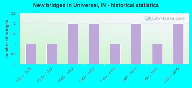
- New bridges - historical statistics
- 11930-1939
- 11940-1949
- 21950-1959
- 21960-1969
- 11970-1979
- 21980-1989
- 11990-1999
- 22000-2009

- Reconstructed bridges - Historical Statistics
- 11970-1979
- 01980-1989
- 11990-1999
- 12000-2009
- 22010-2019


- Bridge Condition - Deck
- 36.4%Good
- 36.4%Satisfactory
- 27.3%Fair

- Bridge Condition - Superstructure
- 18.2%Very good
- 45.5%Good
- 18.2%Satisfactory
- 18.2%Fair

- Bridge Condition - Substructure
- 9.1%Very good
- 72.7%Good
- 9.1%Satisfactory
- 9.1%Fair

- Bridge Condition - Channel
- 58.3%Good
- 33.3%Satisfactory
- 8.3%Fair
Find on map >> Show street view
Structure Number: 938, Location: 02.61 S SR 44 (Lat: 39.450739, Lng: -86.034489), Route carried "on" structure: US 31, Year Built: 1946, Year Reconstructed: 1978, Status: Open, Structure Length: 6.25m (20.51ft), Average Daily Traffic: 6,231 (year 2004), Truck Traffic: 10%, Average Future Daily Traffic: 10,603 (year 2031), Design Load: HS 20, Features Intersected: YOUNGS CREEK
Minimum Vertical Clearance: 30+ m (98+ ft), Kilometerpoint: 13.164, Lanes on structure: 2, Owner: State Highway Agency, Approaching Roadway Width: 12.2m (40.0ft), Skew: 1 degrees, Material/Design: Concrete, Design/Construction: Arch - Deck, Number Of Spans In Main Unit: 2, Length of Maximum Span: 19.8m (65.0ft), Curb-To-Curb Width: 9.7m (31.8ft), Out-to-Out Width: 10.5m (34.4ft)
Condition: Deck: Good, Superstructure: Fair, Substructure: Fair, Channel: Satisfactory, Operating Rating: 70.9 metric tons, Method Used To Determine Operating Rating: Field evaluation and documented engineering judgment, Inventory Rating: 42.4 metric tons, Method Used To Determine Inventory Rating: Field evaluation and documented engineering judgment, Structural Evaluation: Somewhat better than minimum adequacy, Deck Geometry: Meets minimum limits, Waterway Adequacy: Better than present minimum criteria, Approach Roadway Alignment: Equal to present desirable criteria, Designated Inspection Frequency: Every 24 months, Inspection Date: October 2020, Deck Structure Type: Concrete Cast-file-Place, Wearing Surface/Protective System: Wearing Surface: Bituminous
Find on map >> Show street view
Structure Number: 2264, Location: 02.75 S SR 163 (Lat: 39.618881, Lng: -87.435939), Route carried "on" structure: State highway 63, Year Built: 1964, Year Reconstructed: 2002, Status: Open, Structure Length: 15.26m (50.07ft), Average Daily Traffic: 12,010 (year 2020), Truck Traffic: 17%, Average Future Daily Traffic: 12,860 (year 2040), Design Load: HS 20, Features Intersected: BROUILLETTS CREEK
Minimum Vertical Clearance: 30+ m (98+ ft), Kilometerpoint: 1.271, Lanes on structure: 2, Base Highway Network: Yes (, Subroute: 1), Owner: State Highway Agency, Approaching Roadway Width: 11.6m (38.1ft), Skew: 3 degrees, Material/Design: Steel continuous, Design/Construction: Stringer/Multi-beam, Number Of Spans In Main Unit: 7, Length of Maximum Span: 27.4m (89.9ft), Curb-To-Curb Width: 11.4m (37.4ft), Out-to-Out Width: 12.3m (40.4ft)
Condition: Deck: Satisfactory, Superstructure: Good, Substructure: Good, Channel: Good, Operating Rating: 32.1 metric tons, Method Used To Determine Operating Rating: Load and Resistance Factor Rating (LRFR) rating reported by rating factor(RF) method using HL-93 loadings, Inventory Rating: 24.9 metric tons, Method Used To Determine Inventory Rating: Load and Resistance Factor Rating (LRFR) rating reported by rating factor(RF) method using HL-93 loadings, Structural Evaluation: Equal to present minimum criteria, Deck Geometry: Equal to present minimum criteria, Waterway Adequacy: Superior to present desirable criteria, Approach Roadway Alignment: Equal to present desirable criteria, Designated Inspection Frequency: Every 24 months, Inspection Date: January 2021, Deck Structure Type: Concrete Cast-file-Place, Wearing Surface/Protective System: Wearing Surface: Epoxy Overlay, Deck Protection: Epoxy Coated Reinforcing
Find on map >> Show street view
Structure Number: 22645, Location: 02.75 S SR 163 (Lat: 39.618931, Lng: -87.436219), Route carried "on" structure: State highway 63, Year Built: 1974, Year Reconstructed: 2010, Status: Open, Structure Length: 15.28m (50.13ft), Average Daily Traffic: 5,415 (year 2010), Truck Traffic: 17%, Average Future Daily Traffic: 7,501 (year 2030), Design Load: HS 20, Features Intersected: BROUILLETTS CREEK
Minimum Vertical Clearance: 30+ m (98+ ft), Kilometerpoint: 1.271, Lanes on structure: 2, Base Highway Network: Yes (, Subroute: 1), Owner: State Highway Agency, Approaching Roadway Width: 11.6m (38.1ft), Skew: 3 degrees, Material/Design: Steel continuous, Design/Construction: Stringer/Multi-beam, Number Of Spans In Main Unit: 5, Number Of Approach Spans: 2, Length of Maximum Span: 27.4m (89.9ft), Curb-To-Curb Width: 12.1m (39.7ft), Out-to-Out Width: 13.0m (42.7ft)
Condition: Deck: Satisfactory, Superstructure: Fair, Substructure: Good, Channel: Good, Operating Rating: 38.9 metric tons, Method Used To Determine Operating Rating: Load and Resistance Factor Rating (LRFR) rating reported by rating factor(RF) method using HL-93 loadings, Inventory Rating: 30.1 metric tons, Method Used To Determine Inventory Rating: Load and Resistance Factor Rating (LRFR) rating reported by rating factor(RF) method using HL-93 loadings, Structural Evaluation: Somewhat better than minimum adequacy, Deck Geometry: Better than present minimum criteria, Waterway Adequacy: Superior to present desirable criteria, Approach Roadway Alignment: Equal to present desirable criteria, Designated Inspection Frequency: Every 24 months, Other Special Inspection Frequency: Every 12 months, Inspection Date: January 2021, Other Special Inspection Date: October 2021, Deck Structure Type: Concrete Cast-file-Place, Wearing Surface/Protective System: Wearing Surface: Latex Concrete
Find on map >> Show street view
Structure Number: 2702, Location: 03.88 W SR 39 (Lat: 39.519011, Lng: -86.525319), Route carried "on" structure: State highway 142, Year Built: 1934, Year Reconstructed: 2017, Status: Open, Structure Length: 1.25m (4.10ft), Average Daily Traffic: 1,040 (year 2017), Truck Traffic: 4%, Average Future Daily Traffic: 1,100 (year 2027), Design Load: H 20, Features Intersected: LITTLE ROCK CREEK
Minimum Vertical Clearance: 30+ m (98+ ft), Kilometerpoint: 10.107, Lanes on structure: 2, Owner: State Highway Agency, Approaching Roadway Width: 8.8m (28.9ft), Skew: 3 degrees, Material/Design: Concrete, Design/Construction: Arch - Deck, Number Of Spans In Main Unit: 1, Length of Maximum Span: 9.9m (32.5ft), Curb-To-Curb Width: 9.0m (29.5ft), Out-to-Out Width: 9.9m (32.5ft)
Condition: Deck: Good, Superstructure: Good, Substructure: Good, Channel: Good, Operating Rating: 52.2 metric tons, Method Used To Determine Operating Rating: Field evaluation and documented engineering judgment, Inventory Rating: 31.4 metric tons, Method Used To Determine Inventory Rating: Field evaluation and documented engineering judgment, Structural Evaluation: Better than present minimum criteria, Deck Geometry: Somewhat better than minimum adequacy, Waterway Adequacy: Superior to present desirable criteria, Approach Roadway Alignment: Equal to present desirable criteria, Designated Inspection Frequency: Every 24 months, Inspection Date: Febuary 2022, Deck Structure Type: Concrete Cast-file-Place, Wearing Surface/Protective System: Wearing Surface: Epoxy Overlay, Deck Protection: Epoxy Coated Reinforcing
Find on map >> Show street view
Structure Number: 2703, Location: 00.09 W SR 39 (Lat: 39.508411, Lng: -86.458489), Route carried "on" structure: State highway 142, Year Built: 2005, Status: Open, Structure Length: 1.07m (3.51ft), Average Daily Traffic: 1,700 (year 2004), Truck Traffic: 3%, Average Future Daily Traffic: 2,640 (year 2024), Design Load: HS 20, Features Intersected: BR MILL HOLLOW BRANCH
Minimum Vertical Clearance: 30+ m (98+ ft), Kilometerpoint: 16.206, Lanes on structure: 2, Owner: State Highway Agency, Approaching Roadway Width: 7.3m (24.0ft), Skew: 3 degrees, Material/Design: Concrete, Design/Construction: Culvert, Number Of Spans In Main Unit: 1, Length of Maximum Span: 10.1m (33.1ft), Curb-To-Curb Width: 10.4m (34.1ft), Out-to-Out Width: 10.4m (34.1ft)
Condition: Channel: Fair, Culverts: Good, Operating Rating: 66.4 metric tons, Method Used To Determine Operating Rating: Load and Resistance Factor Rating (LRFR) rating reported by rating factor(RF) method using HL-93 loadings, Inventory Rating: 51.5 metric tons, Method Used To Determine Inventory Rating: Load and Resistance Factor Rating (LRFR) rating reported by rating factor(RF) method using HL-93 loadings, Structural Evaluation: Better than present minimum criteria, Deck Geometry: Equal to present minimum criteria, Waterway Adequacy: Better than present minimum criteria, Approach Roadway Alignment: Equal to present desirable criteria, Designated Inspection Frequency: Every 24 months, Inspection Date: Febuary 2022
Find on map >> Show street view
Structure Number: 2704, Location: 00.07 W SR 67 (Lat: 39.608339, Lng: -86.365819), Route carried "on" structure: State highway 42, Year Built: 1958, Year Reconstructed: 2000, Status: Open, Structure Length: 5.30m (17.39ft), Average Daily Traffic: 13,153 (year 2004), Truck Traffic: 8%, Average Future Daily Traffic: 18,532 (year 2032), Design Load: HS 20, Features Intersected: LITTLE WHITE LICK CREEK
Minimum Vertical Clearance: 30+ m (98+ ft), Kilometerpoint: 38.318, Lanes on structure: 4, Owner: State Highway Agency, Approaching Roadway Width: 18.0m (59.1ft), Skew: 1 degrees, Material/Design: Prestressed concrete continuous, Design/Construction: Stringer/Multi-beam, Number Of Spans In Main Unit: 4, Length of Maximum Span: 13.1m (43.0ft), Curb-To-Curb Width: 18.0m (59.1ft), Out-to-Out Width: 18.9m (62.0ft)
Condition: Deck: Satisfactory, Superstructure: Very good, Substructure: Good, Channel: Good, Operating Rating: 53.7 metric tons, Method Used To Determine Operating Rating: Load Factor (LF), Inventory Rating: 32.2 metric tons, Method Used To Determine Inventory Rating: Load Factor (LF), Structural Evaluation: Better than present minimum criteria, Deck Geometry: Somewhat better than minimum adequacy, Waterway Adequacy: Superior to present desirable criteria, Approach Roadway Alignment: Equal to present desirable criteria, Designated Inspection Frequency: Every 24 months, Inspection Date: April 2020, Deck Structure Type: Concrete Cast-file-Place, Wearing Surface/Protective System: Wearing Surface: Monolithic Concrete, Deck Protection: Epoxy Coated Reinforcing
Find on map >> Show street view
Structure Number: 8300002, Location: 00.10 N of WOOD Ave (Lat: 39.623369, Lng: -87.441511), Route carried "on" structure: County highway 55, Year Built: 1965, Status: Open, Structure Length: 5.43m (17.81ft), Average Daily Traffic: 610 (year 2017), Truck Traffic: 5%, Average Future Daily Traffic: 712 (year 2037), Design Load: HS 20, Features Intersected: BROUILLETTS CREEK, Facility Carried by Structure: CR 110E
Minimum Vertical Clearance: 30+ m (98+ ft), Kilometerpoint: 0.000, Lanes on structure: 2, Owner: County Highway Agency, Approaching Roadway Width: 5.8m (19.0ft), Skew: 1 degrees, Material/Design: Prestressed concrete, Design/Construction: Stringer/Multi-beam, Number Of Spans In Main Unit: 3, Length of Maximum Span: 22.9m (75.1ft), Curb-To-Curb Width: 6.0m (19.7ft), Out-to-Out Width: 6.1m (20.0ft)
Condition: Deck: Fair, Superstructure: Good, Substructure: Good, Channel: Satisfactory, Operating Rating: 63.4 metric tons, Method Used To Determine Operating Rating: Load Factor (LF), Inventory Rating: 29.5 metric tons, Method Used To Determine Inventory Rating: Load Factor (LF), Structural Evaluation: Better than present minimum criteria, Deck Geometry: High priority of replacement, Waterway Adequacy: Better than present minimum criteria, Approach Roadway Alignment: High priority of corrective action, Length Of Structure Improvement: 6.52m (21.39ft), Designated Inspection Frequency: Every 24 months, Inspection Date: August 2021, Bridge Improvement Cost: $975,000, Roadway Improvement Cost: $195,000, Total Project Cost: $1,579,000 ( Estimate for 2021), Deck Structure Type: Concrete Cast-file-Place, Wearing Surface/Protective System: Wearing Surface: Monolithic Concrete
Find on map >> Show street view
Structure Number: 8300004, Location: 00.60 S of CR 1800 S (Lat: 39.611500, Lng: -87.462911), Route carried "on" structure: County highway , Year Built: 1991, Status: Open, Structure Length: 2.26m (7.41ft), Average Daily Traffic: 233 (year 2017), Truck Traffic: 5%, Average Future Daily Traffic: 272 (year 2037), Design Load: HS 20, Features Intersected: GIN CREEK, Facility Carried by Structure: CR 00E
Minimum Vertical Clearance: 30+ m (98+ ft), Kilometerpoint: 0.000, Lanes on structure: 2, Owner: County Highway Agency, Approaching Roadway Width: 6.4m (21.0ft), Material/Design: Wood or Timber, Design/Construction: Slab, Number Of Spans In Main Unit: 3, Length of Maximum Span: 7.6m (24.9ft), Curb-To-Curb Width: 7.4m (24.3ft), Out-to-Out Width: 7.8m (25.6ft)
Condition: Deck: Satisfactory, Superstructure: Satisfactory, Substructure: Good, Channel: Satisfactory, Operating Rating: 54.2 metric tons, Method Used To Determine Operating Rating: Allowable Stress (AS), Inventory Rating: 38.4 metric tons, Method Used To Determine Inventory Rating: Allowable Stress (AS), Structural Evaluation: Equal to present minimum criteria, Deck Geometry: Somewhat better than minimum adequacy, Waterway Adequacy: Equal to present minimum criteria, Approach Roadway Alignment: Equal to present desirable criteria, Designated Inspection Frequency: Every 24 months, Inspection Date: August 2021, Deck Structure Type: Wood or Timber, Wearing Surface/Protective System: Wearing Surface: Bituminous
Find on map >> Show street view
Structure Number: 8300005, Location: 00.60 N of CR 1800 S (Lat: 39.630131, Lng: -87.463311), Route carried "on" structure: County highway , Year Built: 1955, Status: Open, Structure Length: 8.89m (29.17ft), Average Daily Traffic: 639 (year 2017), Truck Traffic: 5%, Average Future Daily Traffic: 745 (year 2037), Design Load: HS 20, Features Intersected: BROUILLETTS CREEK, Facility Carried by Structure: CR 00E
Minimum Vertical Clearance: 30+ m (98+ ft), Kilometerpoint: 0.000, Lanes on structure: 2, Owner: County Highway Agency, Approaching Roadway Width: 6.1m (20.0ft), Skew: 2 degrees, Material/Design: Steel continuous, Design/Construction: Stringer/Multi-beam, Number Of Spans In Main Unit: 4, Length of Maximum Span: 24.4m (80.1ft), Curb-To-Curb Width: 7.3m (24.0ft), Out-to-Out Width: 8.3m (27.2ft)
Condition: Deck: Fair, Superstructure: Satisfactory, Substructure: Satisfactory, Channel: Satisfactory, Operating Rating: 68.0 metric tons, Method Used To Determine Operating Rating: Load Factor (LF), Inventory Rating: 40.8 metric tons, Method Used To Determine Inventory Rating: Load Factor (LF), Structural Evaluation: Equal to present minimum criteria, Deck Geometry: Meets minimum limits, Waterway Adequacy: Better than present minimum criteria, Approach Roadway Alignment: Equal to present desirable criteria, Length Of Structure Improvement: 8.92m (29.27ft), Designated Inspection Frequency: Every 24 months, Inspection Date: August 2021, Bridge Improvement Cost: $996,000, Roadway Improvement Cost: $100,000, Total Project Cost: $1,479,000 ( Estimate for 2021), Deck Structure Type: Concrete Cast-file-Place, Wearing Surface/Protective System: Wearing Surface: Monolithic Concrete
Find on map >> Show street view
Structure Number: 8300006, Location: 00.50 E of RANGELINE (Lat: 39.640511, Lng: -87.455319), Route carried "on" structure: County highway 4, Year Built: 1982, Status: Open, Structure Length: 2.48m (8.14ft), Average Daily Traffic: 349 (year 2017), Truck Traffic: 3%, Average Future Daily Traffic: 407 (year 2037), Design Load: HS 20, Features Intersected: BRANCH OF BROUILLETTS CR, Facility Carried by Structure: CR 1680S
Minimum Vertical Clearance: 30+ m (98+ ft), Kilometerpoint: 0.000, Lanes on structure: 2, Owner: County Highway Agency, Approaching Roadway Width: 6.1m (20.0ft), Material/Design: Concrete continuous, Design/Construction: Slab, Number Of Spans In Main Unit: 3, Length of Maximum Span: 9.4m (30.8ft), Curb-To-Curb Width: 8.5m (27.9ft), Out-to-Out Width: 8.5m (27.9ft)
Condition: Deck: Good, Superstructure: Good, Substructure: Good, Channel: Good, Operating Rating: 68.0 metric tons, Method Used To Determine Operating Rating: Load Factor (LF), Inventory Rating: 40.8 metric tons, Method Used To Determine Inventory Rating: Load Factor (LF), Structural Evaluation: Better than present minimum criteria, Deck Geometry: Equal to present minimum criteria, Waterway Adequacy: Equal to present minimum criteria, Approach Roadway Alignment: Equal to present desirable criteria, Designated Inspection Frequency: Every 24 months, Inspection Date: August 2021, Deck Structure Type: Concrete Cast-file-Place, Wearing Surface/Protective System: Wearing Surface: Monolithic Concrete, Deck Protection: Epoxy Coated Reinforcing
Find on map >> Show street view
Structure Number: 8300007, Location: 00.50 W of RANGELINE (Lat: 39.636331, Lng: -87.473431), Route carried "on" structure: County highway 4, Year Built: 2005, Status: Open, Structure Length: 0.94m (3.08ft), Average Daily Traffic: 117 (year 2017), Truck Traffic: 3%, Average Future Daily Traffic: 136 (year 2037), Design Load: HS 20, Features Intersected: BRANCH OF BROUILLETTS CR, Facility Carried by Structure: CR 1680S
Minimum Vertical Clearance: 30+ m (98+ ft), Kilometerpoint: 0.000, Lanes on structure: 2, Owner: County Highway Agency, Approaching Roadway Width: 4.3m (14.1ft), Material/Design: Steel, Design/Construction: Stringer/Multi-beam, Number Of Spans In Main Unit: 1, Length of Maximum Span: 9.0m (29.5ft), Curb-To-Curb Width: 7.3m (24.0ft), Out-to-Out Width: 7.4m (24.3ft)
Condition: Deck: Fair, Superstructure: Very good, Substructure: Good, Channel: Good, Operating Rating: 68.0 metric tons, Method Used To Determine Operating Rating: Load Factor (LF), Inventory Rating: 40.8 metric tons, Method Used To Determine Inventory Rating: Load Factor (LF), Structural Evaluation: Better than present minimum criteria, Deck Geometry: Somewhat better than minimum adequacy, Waterway Adequacy: Somewhat better than minimum adequacy, Approach Roadway Alignment: Equal to present desirable criteria, Designated Inspection Frequency: Every 24 months, Inspection Date: August 2021, Deck Structure Type: Corrugated Steel, Wearing Surface/Protective System: Wearing Surface: Bituminous
Find on map >> Show street view
Structure Number: 8300008, Location: 00.10 S of CR 1680 S (Lat: 39.634789, Lng: -87.482581), Route carried "on" structure: County highway 17, Year Built: 1986, Status: Open, Structure Length: 6.75m (22.15ft), Average Daily Traffic: 117 (year 2017), Truck Traffic: 3%, Average Future Daily Traffic: 136 (year 2037), Design Load: HS 20, Features Intersected: BROUILLETTS CREEK, Facility Carried by Structure: CR 100W
Minimum Vertical Clearance: 30+ m (98+ ft), Kilometerpoint: 0.000, Lanes on structure: 2, Owner: County Highway Agency, Approaching Roadway Width: 6.1m (20.0ft), Skew: 1 degrees, Material/Design: Prestressed concrete continuous, Design/Construction: Box Beam or Girders - Single/Spread, Number Of Spans In Main Unit: 3, Length of Maximum Span: 22.3m (73.2ft), Curb-To-Curb Width: 7.9m (25.9ft), Out-to-Out Width: 8.7m (28.5ft)
Condition: Deck: Good, Superstructure: Good, Substructure: Very good, Channel: Good, Operating Rating: 59.9 metric tons, Method Used To Determine Operating Rating: Load Factor (LF), Inventory Rating: 36.3 metric tons, Method Used To Determine Inventory Rating: Load Factor (LF), Structural Evaluation: Better than present minimum criteria, Deck Geometry: Somewhat better than minimum adequacy, Waterway Adequacy: Equal to present desirable criteria, Approach Roadway Alignment: Equal to present minimum criteria, Designated Inspection Frequency: Every 24 months, Inspection Date: August 2021, Deck Structure Type: Concrete Cast-file-Place, Wearing Surface/Protective System: Wearing Surface: Monolithic Concrete, Deck Protection: Epoxy Coated Reinforcing