Bridge Statistics for Valley City, North Dakota (ND)
Condition, Traffic, Stress, Structural Evaluation, Project Costs
- National Bridge Inventory (NBI) Statistics
- 41Number of bridges
- 436ft / 133mTotal length
- $735,000Total costs
- 152,750Total average daily traffic
- 24,046Total average daily truck traffic
- National Bridge Inventory (NBI) Registered Bridges for Valley City
- No street view available for this location
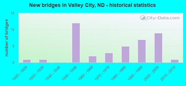
- New bridges - historical statistics
- 11920-1929
- 11930-1939
- 121950-1959
- 21960-1969
- 31970-1979
- 51980-1989
- 71990-1999
- 92000-2009
- 12010-2019
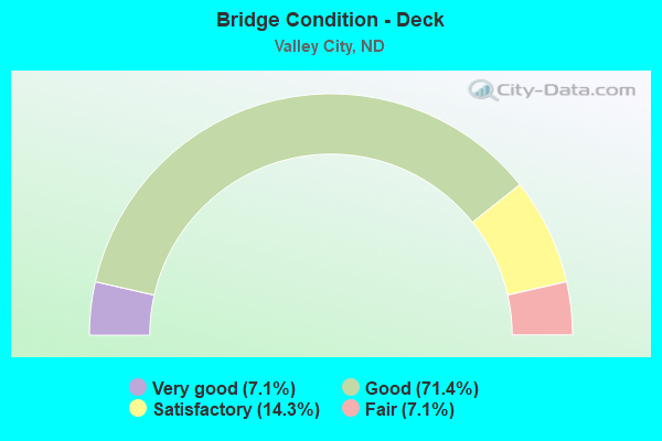
- Bridge Condition - Deck
- 7.1%Very good
- 71.4%Good
- 14.3%Satisfactory
- 7.1%Fair
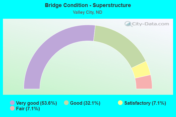
- Bridge Condition - Superstructure
- 53.6%Very good
- 32.1%Good
- 7.1%Satisfactory
- 7.1%Fair
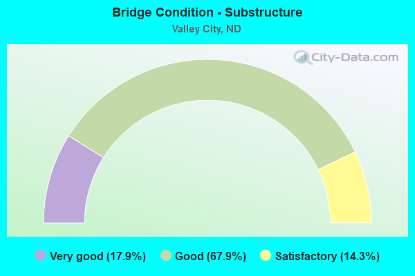
- Bridge Condition - Substructure
- 17.9%Very good
- 67.9%Good
- 14.3%Satisfactory
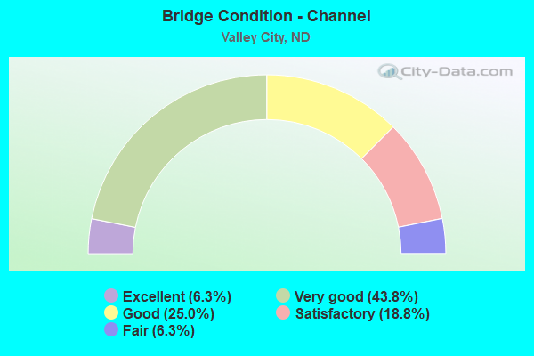
- Bridge Condition - Channel
- 6.3%Excellent
- 43.8%Very good
- 25.0%Good
- 18.8%Satisfactory
- 6.3%Fair
Find on map >> Show street view
Structure Number: 211721, Location: BEREA (Lat: 46.935053, Lng: -98.101942), Route carried "on" structure: County highway 222, Year Built: 1986, Status: Open, Structure Length: 5.52m (18.11ft), Average Daily Traffic: 720 (year 2018), Truck Traffic: 12%, Average Future Daily Traffic: 500 (year 2038), Design Load: HS 20, Features Intersected: BURLINGTON NORTHERN RR, Facility Carried by Structure: COUNTY HIGHWAY
Minimum Vertical Clearance: 30+ m (98+ ft), Kilometerpoint: 25.744, Lanes on structure: 2, Owner: County Highway Agency, Approaching Roadway Width: 8.5m (27.9ft), Skew: 3 degrees, Material/Design: Prestressed concrete continuous, Design/Construction: Box Beam or Girders - Single/Spread, Number Of Spans In Main Unit: 3, Length of Maximum Span: 19.2m (63.0ft), Curb-To-Curb Width: 9.1m (29.9ft), Out-to-Out Width: 10.5m (34.4ft)
Condition: Deck: Good, Superstructure: Very good, Substructure: Very good, Operating Rating: 55.7 metric tons, Method Used To Determine Operating Rating: Load Factor (LF), Inventory Rating: 33.3 metric tons, Method Used To Determine Inventory Rating: Load Factor (LF), Structural Evaluation: Equal to present desirable criteria, Deck Geometry: Equal to present minimum criteria, Underclear: Better than present minimum criteria, Approach Roadway Alignment: Equal to present desirable criteria, Designated Inspection Frequency: Every 24 months, Inspection Date: May 2020, Deck Structure Type: Concrete Cast-file-Place, Wearing Surface/Protective System: Wearing Surface: Monolithic Concrete
Find on map >> Show street view
Structure Number: 21212, Location: MARYVALE BRIDGE (Lat: 46.959325, Lng: -98.018464), Route carried "on" structure: County highway , Year Built: 1995, Status: Open, Structure Length: 4.63m (15.19ft), Average Daily Traffic: 90 (year 2018), Average Future Daily Traffic: 90 (year 2038), Design Load: HS 25 or greater, Features Intersected: SHEYENNE RIVER, Facility Carried by Structure: COUNTY HIGHWAY
Minimum Vertical Clearance: 30+ m (98+ ft), Kilometerpoint: 0.000, Lanes on structure: 2, Owner: County Highway Agency, Approaching Roadway Width: 7.3m (24.0ft), Material/Design: Prestressed concrete continuous, Design/Construction: Box Beam or Girders - Single/Spread, Number Of Spans In Main Unit: 3, Length of Maximum Span: 17.4m (57.1ft), Curb-To-Curb Width: 8.5m (27.9ft), Out-to-Out Width: 9.5m (31.2ft)
Condition: Deck: Very good, Superstructure: Very good, Substructure: Very good, Channel: Very good, Operating Rating: 34.0 metric tons, Method Used To Determine Operating Rating: Load Factor (LF), Inventory Rating: 19.3 metric tons, Method Used To Determine Inventory Rating: Load Factor (LF), Structural Evaluation: Somewhat better than minimum adequacy, Deck Geometry: Better than present minimum criteria, Waterway Adequacy: Superior to present desirable criteria, Approach Roadway Alignment: Equal to present desirable criteria, Designated Inspection Frequency: Every 24 months, Inspection Date: May 2020, Deck Structure Type: Concrete Cast-file-Place, Wearing Surface/Protective System: Wearing Surface: Monolithic Concrete
Find on map >> Show street view
Structure Number: 212225, Location: 3 SOUTH OF VALLEY CITY (Lat: 46.883878, Lng: -97.996992), Route carried "on" structure: County highway 221, Year Built: 1969, Status: Open, Structure Length: 3.35m (10.99ft), Average Daily Traffic: 580 (year 2018), Truck Traffic: 9%, Average Future Daily Traffic: 560 (year 2038), Design Load: H 20, Features Intersected: SHEYENNE RIVER
Minimum Vertical Clearance: 30+ m (98+ ft), Kilometerpoint: 27.514, Lanes on structure: 2, Owner: County Highway Agency, Approaching Roadway Width: 7.6m (24.9ft), Material/Design: Prestressed concrete, Design/Construction: Box Beam or Girders - Multiple, Number Of Spans In Main Unit: 3, Length of Maximum Span: 14.6m (47.9ft), Curb or Sidewalk Widths: Left: 0.2m (0.7ft), Right: 0.2m (0.7ft), Curb-To-Curb Width: 8.6m (28.2ft), Out-to-Out Width: 9.3m (30.5ft)
Condition: Deck: Good, Superstructure: Good, Substructure: Good, Channel: Satisfactory, Operating Rating: 97.2 metric tons, Method Used To Determine Operating Rating: Load Factor (LF), Inventory Rating: 43.2 metric tons, Method Used To Determine Inventory Rating: Load Factor (LF), Structural Evaluation: Better than present minimum criteria, Deck Geometry: Somewhat better than minimum adequacy, Waterway Adequacy: Equal to present minimum criteria, Approach Roadway Alignment: Better than present minimum criteria, Designated Inspection Frequency: Every 24 months, Inspection Date: May 2020, Wearing Surface/Protective System: Wearing Surface: Bituminous
Find on map >> Show street view
Structure Number: 212226, Location: 4 SOUTH OF VALLEY CITY (Lat: 46.864719, Lng: -97.997408), Route carried "on" structure: County highway 221, Year Built: 1959, Status: Open, Structure Length: 3.96m (12.99ft), Average Daily Traffic: 580 (year 2018), Truck Traffic: 9%, Average Future Daily Traffic: 515 (year 2038), Design Load: H 15, Features Intersected: SHEYENNE RIVER, Facility Carried by Structure: COUNTY HIGHWAY
Minimum Vertical Clearance: 30+ m (98+ ft), Kilometerpoint: 26.227, Lanes on structure: 2, Owner: County Highway Agency, Approaching Roadway Width: 7.6m (24.9ft), Skew: 4 degrees, Material/Design: Concrete continuous, Design/Construction: Slab, Number Of Spans In Main Unit: 4, Length of Maximum Span: 10.7m (35.1ft), Curb or Sidewalk Widths: Left: 0.3m (1.0ft), Right: 0.3m (1.0ft), Curb-To-Curb Width: 7.4m (24.3ft), Out-to-Out Width: 7.9m (25.9ft)
Condition: Deck: Good, Superstructure: Good, Substructure: Satisfactory, Channel: Fair, Operating Rating: 46.4 metric tons, Method Used To Determine Operating Rating: Load Factor (LF), Inventory Rating: 23.9 metric tons, Method Used To Determine Inventory Rating: Load Factor (LF), Structural Evaluation: Equal to present minimum criteria, Deck Geometry: Meets minimum limits, Waterway Adequacy: Meets minimum limits, Approach Roadway Alignment: Meets minimum limits, Length Of Structure Improvement: 3.96m (12.99ft), Designated Inspection Frequency: Every 24 months, Inspection Date: May 2020, Bridge Improvement Cost: $85,000, Roadway Improvement Cost: $9,000, Total Project Cost: $128,000, Deck Structure Type: Concrete Cast-file-Place, Wearing Surface/Protective System: Wearing Surface: Bituminous
Find on map >> Show street view
Structure Number: 212227, Location: 5 SOUTH OF VALLEY CITY (Lat: 46.848228, Lng: -98.004561), Route carried "on" structure: County highway , Year Built: 1980, Status: Open, Structure Length: 3.78m (12.40ft), Average Daily Traffic: 35 (year 2018), Average Future Daily Traffic: 35 (year 2038), Design Load: H 20, Features Intersected: SHEYENNE RIVER, Facility Carried by Structure: TOWNSHIP ROAD
Minimum Vertical Clearance: 30+ m (98+ ft), Kilometerpoint: 0.000, Lanes on structure: 2, Owner: County Highway Agency, Approaching Roadway Width: 6.7m (22.0ft), Material/Design: Prestressed concrete continuous, Design/Construction: Box Beam or Girders - Single/Spread, Number Of Spans In Main Unit: 3, Length of Maximum Span: 14.6m (47.9ft), Curb-To-Curb Width: 8.6m (28.2ft), Out-to-Out Width: 9.1m (29.9ft)
Condition: Deck: Good, Superstructure: Good, Substructure: Very good, Channel: Good, Operating Rating: 63.4 metric tons, Method Used To Determine Operating Rating: Load Factor (LF), Inventory Rating: 38.0 metric tons, Method Used To Determine Inventory Rating: Load Factor (LF), Structural Evaluation: Better than present minimum criteria, Deck Geometry: Better than present minimum criteria, Waterway Adequacy: Equal to present desirable criteria, Approach Roadway Alignment: Equal to present desirable criteria, Length Of Structure Improvement: 3.78m (12.40ft), Designated Inspection Frequency: Every 24 months, Inspection Date: May 2020, Bridge Improvement Cost: $93,000, Roadway Improvement Cost: $9,000, Total Project Cost: $140,000, Deck Structure Type: Concrete Cast-file-Place, Wearing Surface/Protective System: Wearing Surface: Monolithic Concrete
Find on map >> Show street view
Structure Number: 913421, Location: 3 EAST 3 NORTH MAPLETON (Lat: 46.941783, Lng: -97.988372), Route carried "on" structure: County highway , Year Built: 1989, Status: Open, Structure Length: 1.92m (6.30ft), Average Daily Traffic: 60 (year 2019), Average Future Daily Traffic: 60 (year 2039), Features Intersected: RAYMOND COULEE, Facility Carried by Structure: COUNTY HIGHWAY
Minimum Vertical Clearance: 30+ m (98+ ft), Kilometerpoint: 0.000, Lanes on structure: 2, Owner: County Highway Agency, Approaching Roadway Width: 7.6m (24.9ft), Material/Design: Prestressed concrete, Design/Construction: Tee Beam, Number Of Spans In Main Unit: 1, Length of Maximum Span: 18.0m (59.1ft), Curb-To-Curb Width: 9.7m (31.8ft), Out-to-Out Width: 10.5m (34.4ft)
Condition: Deck: Very good, Superstructure: Very good, Substructure: Good, Channel: Satisfactory, Operating Rating: 65.7 metric tons, Method Used To Determine Operating Rating: Load Factor (LF), Inventory Rating: 39.2 metric tons, Method Used To Determine Inventory Rating: Load Factor (LF), Structural Evaluation: Better than present minimum criteria, Deck Geometry: Better than present minimum criteria, Waterway Adequacy: Better than present minimum criteria, Approach Roadway Alignment: Equal to present desirable criteria, Designated Inspection Frequency: Every 24 months, Inspection Date: June 2021, Deck Structure Type: Concrete Precast Panels
Find on map >> Show street view
Structure Number: VC01, Location: 4TH ST SW-EAST SIDE PARK (Lat: 46.920000, Lng: -98.005000), Route carried "on" structure: City street 9053, Year Built: 1924, Year Reconstructed: 1981, Status: Posted for load, Structure Length: 4.24m (13.91ft), Average Daily Traffic: 3,200 (year 2020), Truck Traffic: 2%, Average Future Daily Traffic: 3,400 (year 2040), Design Load: H 20, Features Intersected: SHEYENNE RIVER, Facility Carried by Structure: 4TH ST SW
Minimum Vertical Clearance: 30+ m (98+ ft), Kilometerpoint: 0.531, Lanes on structure: 2, Owner: County Highway Agency, Approaching Roadway Width: 11.9m (39.0ft), Material/Design: Concrete, Design/Construction: Arch - Deck, Number Of Spans In Main Unit: 3, Length of Maximum Span: 19.5m (64.0ft), Curb or Sidewalk Widths: Left: 1.8m (5.9ft), Right: 2.0m (6.6ft), Curb-To-Curb Width: 7.3m (24.0ft), Out-to-Out Width: 12.1m (39.7ft)
Condition: Deck: Satisfactory, Superstructure: Fair, Substructure: Satisfactory, Channel: Good, Operating Rating: 32.7 metric tons, Method Used To Determine Operating Rating: Field evaluation and documented engineering judgment, Inventory Rating: 22.7 metric tons, Method Used To Determine Inventory Rating: Field evaluation and documented engineering judgment, Structural Evaluation: Somewhat better than minimum adequacy, Deck Geometry: High priority of replacement, Waterway Adequacy: Better than present minimum criteria, Approach Roadway Alignment: Meets minimum limits, Length Of Structure Improvement: 4.24m (13.91ft), Designated Inspection Frequency: Every 24 months, Inspection Date: August 2021, Bridge Improvement Cost: $138,000, Roadway Improvement Cost: $14,000, Total Project Cost: $207,000, Deck Structure Type: Concrete Cast-file-Place, Wearing Surface/Protective System: Wearing Surface: Bituminous
Find on map >> Show street view
Structure Number: VC02, Location: 4TH ST SW-WEST SIDE PARK (Lat: 46.920000, Lng: -98.010000), Route carried "on" structure: City street 9053, Year Built: 2007, Status: Open, Structure Length: 4.75m (15.58ft), Average Daily Traffic: 2,225 (year 2020), Truck Traffic: 2%, Average Future Daily Traffic: 2,715 (year 2040), Design Load: HS 25 or greater, Features Intersected: SHEYENNE RIVER, Facility Carried by Structure: 4TH ST SW
Minimum Vertical Clearance: 30+ m (98+ ft), Kilometerpoint: 0.322, Lanes on structure: 2, Owner: County Highway Agency, Approaching Roadway Width: 11.9m (39.0ft), Skew: 2 degrees, Material/Design: Prestressed concrete, Design/Construction: Box Beam or Girders - Single/Spread, Number Of Spans In Main Unit: 3, Length of Maximum Span: 21.9m (71.9ft), Curb or Sidewalk Widths: Left: 1.8m (5.9ft), Right: 1.8m (5.9ft), Curb-To-Curb Width: 12.2m (40.0ft), Out-to-Out Width: 16.6m (54.5ft)
Condition: Deck: Good, Superstructure: Very good, Substructure: Good, Channel: Excellent, Operating Rating: 89.8 metric tons, Method Used To Determine Operating Rating: Load Factor (LF), Inventory Rating: 32.4 metric tons, Method Used To Determine Inventory Rating: Load Factor (LF), Structural Evaluation: Better than present minimum criteria, Deck Geometry: Equal to present minimum criteria, Waterway Adequacy: Superior to present desirable criteria, Approach Roadway Alignment: Equal to present desirable criteria, Designated Inspection Frequency: Every 24 months, Underwater Inspection Frequency: Every 60 months, Inspection Date: August 2021, Underwater Inspection Date: July 2018, Deck Structure Type: Concrete Cast-file-Place, Wearing Surface/Protective System: Wearing Surface: Monolithic Concrete, Deck Protection: Epoxy Coated Reinforcing
Find on map >> Show street view
Structure Number: VC03, Location: 8TH AVE. SOUTHWEST (Lat: 46.913333, Lng: -98.013333), Route carried "on" structure: City street 9022, Year Built: 1990, Status: Open, Structure Length: 4.27m (14.01ft), Average Daily Traffic: 5,600 (year 2020), Truck Traffic: 2%, Average Future Daily Traffic: 6,200 (year 2040), Design Load: HS 20, Features Intersected: SHEYENNE RIVER, Facility Carried by Structure: CITY STREET
Minimum Vertical Clearance: 30+ m (98+ ft), Kilometerpoint: 0.644, Lanes on structure: 2, Owner: County Highway Agency, Approaching Roadway Width: 13.4m (44.0ft), Skew: 1 degrees, Material/Design: Prestressed concrete continuous, Design/Construction: Box Beam or Girders - Single/Spread, Number Of Spans In Main Unit: 3, Length of Maximum Span: 16.2m (53.1ft), Curb or Sidewalk Widths: Left: 0.0m, Right: 2.7m (8.9ft), Curb-To-Curb Width: 13.4m (44.0ft), Out-to-Out Width: 16.9m (55.4ft)
Condition: Deck: Good, Superstructure: Very good, Substructure: Good, Channel: Very good, Operating Rating: 77.4 metric tons, Method Used To Determine Operating Rating: Load Factor (LF), Inventory Rating: 36.0 metric tons, Method Used To Determine Inventory Rating: Load Factor (LF), Structural Evaluation: Better than present minimum criteria, Deck Geometry: Equal to present minimum criteria, Waterway Adequacy: Better than present minimum criteria, Approach Roadway Alignment: Equal to present desirable criteria, Designated Inspection Frequency: Every 24 months, Inspection Date: August 2021, Deck Structure Type: Concrete Cast-file-Place, Wearing Surface/Protective System: Wearing Surface: Monolithic Concrete, Deck Protection: Epoxy Coated Reinforcing
Find on map >> Show street view
Structure Number: VC04, Location: VIKING DRIVE SOUTHWEST (Lat: 46.913333, Lng: -98.010000), Route carried "on" structure: City street 9061, Year Built: 1969, Status: Open, Structure Length: 3.99m (13.09ft), Average Daily Traffic: 1,600 (year 2020), Truck Traffic: 3%, Average Future Daily Traffic: 2,000 (year 2040), Design Load: H 20, Features Intersected: SHEYENNE RIVER, Facility Carried by Structure: VIKING DRIVE SW
Minimum Vertical Clearance: 30+ m (98+ ft), Kilometerpoint: 0.241, Lanes on structure: 2, Owner: County Highway Agency, Approaching Roadway Width: 12.2m (40.0ft), Skew: 6 degrees, Material/Design: Prestressed concrete, Design/Construction: Box Beam or Girders - Multiple, Number Of Spans In Main Unit: 3, Length of Maximum Span: 14.6m (47.9ft), Curb or Sidewalk Widths: Left: 0.3m (1.0ft), Right: 1.2m (3.9ft), Curb-To-Curb Width: 8.6m (28.2ft), Out-to-Out Width: 10.2m (33.5ft)
Condition: Deck: Fair, Superstructure: Fair, Substructure: Good, Channel: Very good, Operating Rating: 48.6 metric tons, Method Used To Determine Operating Rating: Allowable Stress (AS), Inventory Rating: 24.3 metric tons, Method Used To Determine Inventory Rating: Allowable Stress (AS), Structural Evaluation: Somewhat better than minimum adequacy, Deck Geometry: Somewhat better than minimum adequacy, Waterway Adequacy: Equal to present minimum criteria, Approach Roadway Alignment: Equal to present minimum criteria, Length Of Structure Improvement: 3.99m (13.09ft), Designated Inspection Frequency: Every 24 months, Inspection Date: August 2021, Bridge Improvement Cost: $110,000, Roadway Improvement Cost: $11,000, Total Project Cost: $165,000, Deck Structure Type: Concrete Precast Panels
Find on map >> Show street view
Structure Number: VC05, Location: 3RD AVE SE-VALLEY CITY (Lat: 46.920000, Lng: -97.996667), Route carried "on" structure: City street 9056, Year Built: 1991, Status: Open, Structure Length: 4.27m (14.01ft), Average Daily Traffic: 1,700 (year 2020), Truck Traffic: 3%, Average Future Daily Traffic: 1,900 (year 2040), Design Load: HS 25 or greater, Features Intersected: SHEYENNE RIVER, Facility Carried by Structure: 3RD AVENUE SE
Minimum Vertical Clearance: 30+ m (98+ ft), Kilometerpoint: 0.724, Lanes on structure: 2, Owner: County Highway Agency, Approaching Roadway Width: 12.2m (40.0ft), Skew: 1 degrees, Material/Design: Prestressed concrete continuous, Design/Construction: Box Beam or Girders - Single/Spread, Number Of Spans In Main Unit: 3, Length of Maximum Span: 17.1m (56.1ft), Curb or Sidewalk Widths: Left: 0.0m, Right: 2.3m (7.5ft), Curb-To-Curb Width: 9.8m (32.2ft), Out-to-Out Width: 12.9m (42.3ft)
Condition: Deck: Good, Superstructure: Very good, Substructure: Very good, Channel: Very good, Operating Rating: 89.8 metric tons, Method Used To Determine Operating Rating: Load Factor (LF), Inventory Rating: 21.6 metric tons, Method Used To Determine Inventory Rating: Load Factor (LF), Structural Evaluation: Somewhat better than minimum adequacy, Deck Geometry: Somewhat better than minimum adequacy, Waterway Adequacy: Equal to present desirable criteria, Approach Roadway Alignment: Equal to present desirable criteria, Designated Inspection Frequency: Every 24 months, Inspection Date: August 2021, Deck Structure Type: Concrete Cast-file-Place, Wearing Surface/Protective System: Wearing Surface: Monolithic Concrete, Deck Protection: Epoxy Coated Reinforcing
Find on map >> Show street view
Structure Number: VC06, Location: 6TH STREET NE (Lat: 46.928333, Lng: -97.991667), Route carried "on" structure: City street 9025, Year Built: 1982, Status: Open, Structure Length: 7.77m (25.49ft), Average Daily Traffic: 1,925 (year 2020), Truck Traffic: 3%, Average Future Daily Traffic: 2,100 (year 2040), Design Load: H 20, Features Intersected: SHEYENNE RIVER, Facility Carried by Structure: 6TH STREET NE
Minimum Vertical Clearance: 30+ m (98+ ft), Kilometerpoint: 1.287, Lanes on structure: 2, Owner: County Highway Agency, Approaching Roadway Width: 9.4m (30.8ft), Skew: 1 degrees, Material/Design: Steel, Design/Construction: Stringer/Multi-beam, Number Of Spans In Main Unit: 3, Length of Maximum Span: 29.6m (97.1ft), Curb or Sidewalk Widths: Left: 1.9m (6.2ft), Right: 0.7m (2.3ft), Curb-To-Curb Width: 11.1m (36.4ft), Out-to-Out Width: 14.3m (46.9ft)
Condition: Deck: Satisfactory, Superstructure: Very good, Substructure: Good, Channel: Very good, Operating Rating: 60.2 metric tons, Method Used To Determine Operating Rating: Load Factor (LF), Inventory Rating: 36.0 metric tons, Method Used To Determine Inventory Rating: Load Factor (LF), Structural Evaluation: Better than present minimum criteria, Deck Geometry: Equal to present minimum criteria, Waterway Adequacy: Equal to present desirable criteria, Approach Roadway Alignment: Equal to present minimum criteria, Designated Inspection Frequency: Every 24 months, Inspection Date: August 2021, Deck Structure Type: Concrete Cast-file-Place, Wearing Surface/Protective System: Wearing Surface: Monolithic Concrete
Find on map >> Show street view
Structure Number: VC07, Location: 5TH AVE SE (Lat: 46.921667, Lng: -97.993333), Route carried "on" structure: City street , Year Built: 1989, Status: Open, Structure Length: 5.21m (17.09ft), Average Daily Traffic: 2,225 (year 2020), Truck Traffic: 2%, Average Future Daily Traffic: 2,500 (year 2040), Design Load: HS 20, Features Intersected: SHEYENNE RIVER, Facility Carried by Structure: 5TH AVE. SE
Minimum Vertical Clearance: 30+ m (98+ ft), Kilometerpoint: 0.000, Lanes on structure: 2, Owner: County Highway Agency, Approaching Roadway Width: 9.1m (29.9ft), Material/Design: Prestressed concrete continuous, Design/Construction: Box Beam or Girders - Single/Spread, Number Of Spans In Main Unit: 3, Length of Maximum Span: 17.7m (58.1ft), Curb or Sidewalk Widths: Left: 0.4m (1.3ft), Right: 2.1m (6.9ft), Curb-To-Curb Width: 9.1m (29.9ft), Out-to-Out Width: 11.9m (39.0ft)
Condition: Deck: Good, Superstructure: Very good, Substructure: Good, Channel: Very good, Operating Rating: 77.4 metric tons, Method Used To Determine Operating Rating: Load Factor (LF), Inventory Rating: 36.0 metric tons, Method Used To Determine Inventory Rating: Load Factor (LF), Structural Evaluation: Better than present minimum criteria, Deck Geometry: Meets minimum limits, Waterway Adequacy: Equal to present desirable criteria, Approach Roadway Alignment: Equal to present desirable criteria, Designated Inspection Frequency: Every 24 months, Inspection Date: August 2021, Deck Structure Type: Concrete Cast-file-Place, Wearing Surface/Protective System: Wearing Surface: Monolithic Concrete
Find on map >> Show street view
Structure Number: VC08, Location: NORTH VALLEY ROAD (Lat: 46.941667, Lng: -97.995000), Route carried "on" structure: County highway 9064, Year Built: 2012, Status: Open, Structure Length: 6.52m (21.39ft), Average Daily Traffic: 1,400 (year 2020), Truck Traffic: 10%, Average Future Daily Traffic: 1,800 (year 2040), Design Load: HL 93, Features Intersected: SHEYENNE RIVER, Facility Carried by Structure: 5TH AVE NE
Minimum Vertical Clearance: 30+ m (98+ ft), Kilometerpoint: 0.611, Lanes on structure: 2, Owner: County Highway Agency, Approaching Roadway Width: 7.3m (24.0ft), Material/Design: Prestressed concrete, Design/Construction: Box Beam or Girders - Single/Spread, Number Of Spans In Main Unit: 3, Length of Maximum Span: 25.0m (82.0ft), Curb or Sidewalk Widths: Left: 0.3m (1.0ft), Right: 3.7m (12.1ft), Curb-To-Curb Width: 9.8m (32.2ft), Out-to-Out Width: 13.7m (44.9ft)
Condition: Deck: Good, Superstructure: Very good, Substructure: Very good, Channel: Very good, Operating Rating: 86.2 metric tons, Method Used To Determine Operating Rating: Load Factor (LF), Inventory Rating: 34.5 metric tons, Method Used To Determine Inventory Rating: Load Factor (LF), Structural Evaluation: Equal to present desirable criteria, Deck Geometry: Somewhat better than minimum adequacy, Waterway Adequacy: Equal to present desirable criteria, Approach Roadway Alignment: Equal to present desirable criteria, Length Of Structure Improvement: 4.88m (16.01ft), Designated Inspection Frequency: Every 24 months, Inspection Date: August 2021, Bridge Improvement Cost: $63,000, Roadway Improvement Cost: $6,000, Total Project Cost: $95,000, Deck Structure Type: Concrete Cast-file-Place, Wearing Surface/Protective System: Wearing Surface: Monolithic Concrete, Deck Protection: Epoxy Coated Reinforcing
Find on map >> Show street view
Structure Number: 94288636, Location: JCT ND 1 SOUTH (Lat: 46.911667, Lng: -98.081667), Route carried "on" structure: State highway 1, Year Built: 1958, Year Reconstructed: 1979, Status: Open, Structure Length: 6.71m (22.01ft), Average Daily Traffic: 900 (year 2020), Truck Traffic: 17%, Average Future Daily Traffic: 900 (year 2040), Design Load: HS 20, Features Intersected: I-94/OAKES INTERCHANGE
Minimum Vertical Clearance: 30+ m (98+ ft), Kilometerpoint: 114.120, Lanes on structure: 2, Lanes under structure: 4, Base Highway Network: Yes, Owner: State Highway Agency, Approaching Roadway Width: 7.6m (24.9ft), Skew: 1 degrees, Material/Design: Concrete continuous, Design/Construction: Tee Beam, Number Of Spans In Main Unit: 4, Length of Maximum Span: 18.9m (62.0ft), Curb-To-Curb Width: 9.1m (29.9ft), Out-to-Out Width: 9.6m (31.5ft)
Condition: Deck: Fair, Superstructure: Satisfactory, Substructure: Satisfactory, Operating Rating: 65.0 metric tons, Method Used To Determine Operating Rating: Load Factor (LF), Inventory Rating: 38.9 metric tons, Method Used To Determine Inventory Rating: Load Factor (LF), Structural Evaluation: Equal to present minimum criteria, Deck Geometry: Equal to present minimum criteria, Underclear: Somewhat better than minimum adequacy, Approach Roadway Alignment: Somewhat better than minimum adequacy, Designated Inspection Frequency: Every 24 months, Inspection Date: September 2021, Deck Structure Type: Concrete Cast-file-Place, Wearing Surface/Protective System: Wearing Surface: Low Slump Concrete
Find on map >> Show street view
Structure Number: 94290803 L, Location: 2 EAST OF ND 1 SOUTH-VC (Lat: 46.911667, Lng: -98.036667), Route carried "on" structure: Interstate 94, Year Built: 2000, Status: Open, Structure Length: 3.99m (13.09ft), Average Daily Traffic: 4,150 (year 2020), Truck Traffic: 20%, Average Future Daily Traffic: 4,150 (year 2040), Design Load: HS 25 or greater, Features Intersected: WEST VALLEY CITY INT
Minimum Vertical Clearance: 30+ m (98+ ft), Kilometerpoint: 467.902, Lanes on structure: 3, Lanes under structure: 2, Base Highway Network: Yes, Owner: State Highway Agency, Approaching Roadway Width: 11.6m (38.1ft), Skew: 10 degrees, Material/Design: Prestressed concrete continuous, Design/Construction: Box Beam or Girders - Single/Spread, Number Of Spans In Main Unit: 3, Length of Maximum Span: 15.8m (51.8ft), Curb-To-Curb Width: 14.6m (47.9ft), Out-to-Out Width: 15.4m (50.5ft)
Condition: Deck: Good, Superstructure: Very good, Substructure: Good, Operating Rating: 89.8 metric tons, Method Used To Determine Operating Rating: Load Factor (LF), Inventory Rating: 57.1 metric tons, Method Used To Determine Inventory Rating: Load Factor (LF), Structural Evaluation: Better than present minimum criteria, Deck Geometry: Meets minimum limits, Underclear: Somewhat better than minimum adequacy, Approach Roadway Alignment: Equal to present desirable criteria, Designated Inspection Frequency: Every 24 months, Inspection Date: September 2021, Deck Structure Type: Concrete Cast-file-Place, Wearing Surface/Protective System: Wearing Surface: Monolithic Concrete, Deck Protection: Epoxy Coated Reinforcing
Find on map >> Show street view
Structure Number: 94290803 R, Location: 2 EAST OF ND 1 SOUTH-VC (Lat: 46.912031, Lng: -98.036286), Route carried "on" structure: Interstate 94, Year Built: 2001, Status: Open, Structure Length: 3.99m (13.09ft), Average Daily Traffic: 4,150 (year 2020), Truck Traffic: 20%, Average Future Daily Traffic: 4,150 (year 2040), Design Load: HS 25 or greater, Features Intersected: WEST VALLEY CITY INT
Minimum Vertical Clearance: 30+ m (98+ ft), Kilometerpoint: 467.902, Lanes on structure: 2, Lanes under structure: 2, Base Highway Network: Yes, Owner: State Highway Agency, Approaching Roadway Width: 11.6m (38.1ft), Skew: 10 degrees, Material/Design: Prestressed concrete continuous, Design/Construction: Box Beam or Girders - Single/Spread, Number Of Spans In Main Unit: 3, Length of Maximum Span: 15.8m (51.8ft), Curb-To-Curb Width: 12.2m (40.0ft), Out-to-Out Width: 13.0m (42.7ft)
Condition: Deck: Good, Superstructure: Very good, Substructure: Good, Operating Rating: 88.0 metric tons, Method Used To Determine Operating Rating: Load Factor (LF), Inventory Rating: 52.7 metric tons, Method Used To Determine Inventory Rating: Load Factor (LF), Structural Evaluation: Better than present minimum criteria, Deck Geometry: Better than present minimum criteria, Underclear: Somewhat better than minimum adequacy, Approach Roadway Alignment: Equal to present desirable criteria, Designated Inspection Frequency: Every 24 months, Inspection Date: September 2021, Deck Structure Type: Concrete Cast-file-Place, Wearing Surface/Protective System: Wearing Surface: Monolithic Concrete, Deck Protection: Other Coated Reinforcing
Find on map >> Show street view
Structure Number: 94291511 L, Location: 3 EAST OF ND 1 SOUTH (Lat: 46.911667, Lng: -98.020000), Route carried "on" structure: Interstate 94, Year Built: 1990, Status: Open, Structure Length: 5.58m (18.31ft), Average Daily Traffic: 4,150 (year 2020), Truck Traffic: 20%, Average Future Daily Traffic: 4,150 (year 2040), Design Load: HS 20, Features Intersected: SHEYENNE RIVER
Minimum Vertical Clearance: 30+ m (98+ ft), Kilometerpoint: 469.041, Lanes on structure: 2, Base Highway Network: Yes, Owner: State Highway Agency, Approaching Roadway Width: 11.6m (38.1ft), Skew: 10 degrees, Material/Design: Prestressed concrete continuous, Design/Construction: Box Beam or Girders - Single/Spread, Number Of Spans In Main Unit: 3, Length of Maximum Span: 18.9m (62.0ft), Curb-To-Curb Width: 12.2m (40.0ft), Out-to-Out Width: 13.0m (42.7ft)
Condition: Deck: Good, Superstructure: Very good, Substructure: Good, Channel: Satisfactory, Operating Rating: 89.8 metric tons, Method Used To Determine Operating Rating: Load Factor (LF), Inventory Rating: 55.2 metric tons, Method Used To Determine Inventory Rating: Load Factor (LF), Structural Evaluation: Better than present minimum criteria, Deck Geometry: Better than present minimum criteria, Waterway Adequacy: Equal to present desirable criteria, Approach Roadway Alignment: Better than present minimum criteria, Designated Inspection Frequency: Every 24 months, Inspection Date: September 2021, Deck Structure Type: Concrete Cast-file-Place, Wearing Surface/Protective System: Wearing Surface: Monolithic Concrete, Deck Protection: Epoxy Coated Reinforcing
Find on map >> Show street view
Structure Number: 94291511 R, Location: 3 EAST OF ND 1 SOUTH (Lat: 46.911667, Lng: -98.020000), Route carried "on" structure: Interstate 94, Year Built: 1990, Status: Open, Structure Length: 5.58m (18.31ft), Average Daily Traffic: 4,150 (year 2020), Truck Traffic: 20%, Average Future Daily Traffic: 4,150 (year 2040), Design Load: HS 20, Features Intersected: SHEYENNE RIVER
Minimum Vertical Clearance: 30+ m (98+ ft), Kilometerpoint: 469.041, Lanes on structure: 2, Base Highway Network: Yes, Owner: State Highway Agency, Approaching Roadway Width: 11.6m (38.1ft), Skew: 10 degrees, Material/Design: Prestressed concrete continuous, Design/Construction: Box Beam or Girders - Single/Spread, Number Of Spans In Main Unit: 3, Length of Maximum Span: 18.9m (62.0ft), Curb-To-Curb Width: 12.2m (40.0ft), Out-to-Out Width: 13.0m (42.7ft)
Condition: Deck: Good, Superstructure: Very good, Substructure: Good, Channel: Good, Operating Rating: 89.8 metric tons, Method Used To Determine Operating Rating: Load Factor (LF), Inventory Rating: 55.2 metric tons, Method Used To Determine Inventory Rating: Load Factor (LF), Structural Evaluation: Better than present minimum criteria, Deck Geometry: Better than present minimum criteria, Waterway Adequacy: Equal to present desirable criteria, Approach Roadway Alignment: Equal to present desirable criteria, Designated Inspection Frequency: Every 24 months, Inspection Date: September 2021, Deck Structure Type: Concrete Cast-file-Place, Wearing Surface/Protective System: Wearing Surface: Monolithic Concrete, Deck Protection: Epoxy Coated Reinforcing
Find on map >> Show street view
Structure Number: 94292072 L, Location: 4 EAST OF ND 1 SOUTH (Lat: 46.910000, Lng: -98.008333), Route carried "on" structure: Interstate 94, Year Built: 1958, Year Reconstructed: 1977, Status: Open, Structure Length: 3.35m (10.99ft), Average Daily Traffic: 4,100 (year 2020), Truck Traffic: 20%, Average Future Daily Traffic: 4,100 (year 2040), Design Load: HS 20, Features Intersected: CO HWY/KATHRYN INTERCHG
Minimum Vertical Clearance: 30+ m (98+ ft), Kilometerpoint: 469.944, Lanes on structure: 2, Lanes under structure: 2, Base Highway Network: Yes, Owner: State Highway Agency, Approaching Roadway Width: 11.6m (38.1ft), Skew: 10 degrees, Material/Design: Concrete continuous, Design/Construction: Slab, Number Of Spans In Main Unit: 3, Length of Maximum Span: 12.5m (41.0ft), Curb-To-Curb Width: 12.2m (40.0ft), Out-to-Out Width: 12.9m (42.3ft)
Condition: Deck: Good, Superstructure: Good, Substructure: Good, Operating Rating: 57.3 metric tons, Method Used To Determine Operating Rating: Load Factor (LF), Inventory Rating: 30.9 metric tons, Method Used To Determine Inventory Rating: Load Factor (LF), Structural Evaluation: Better than present minimum criteria, Deck Geometry: Better than present minimum criteria, Underclear: Meets minimum limits, Approach Roadway Alignment: Better than present minimum criteria, Designated Inspection Frequency: Every 24 months, Inspection Date: September 2021, Deck Structure Type: Concrete Cast-file-Place, Wearing Surface/Protective System: Wearing Surface: Low Slump Concrete
Find on map >> Show street view
Structure Number: 94292072 R, Location: 4 EAST OF ND 1 SOUTH (Lat: 46.910000, Lng: -98.008333), Route carried "on" structure: Interstate 94, Year Built: 1958, Year Reconstructed: 1977, Status: Open, Structure Length: 3.35m (10.99ft), Average Daily Traffic: 4,100 (year 2020), Truck Traffic: 20%, Average Future Daily Traffic: 4,100 (year 2040), Design Load: HS 20, Features Intersected: CO HWY/KATHRYN INTERCHG
Minimum Vertical Clearance: 30+ m (98+ ft), Kilometerpoint: 469.944, Lanes on structure: 2, Lanes under structure: 2, Base Highway Network: Yes, Owner: State Highway Agency, Approaching Roadway Width: 11.6m (38.1ft), Skew: 10 degrees, Material/Design: Concrete continuous, Design/Construction: Slab, Number Of Spans In Main Unit: 3, Length of Maximum Span: 12.5m (41.0ft), Curb-To-Curb Width: 12.1m (39.7ft), Out-to-Out Width: 12.9m (42.3ft)
Condition: Deck: Good, Superstructure: Good, Substructure: Good, Operating Rating: 57.3 metric tons, Method Used To Determine Operating Rating: Load Factor (LF), Inventory Rating: 30.9 metric tons, Method Used To Determine Inventory Rating: Load Factor (LF), Structural Evaluation: Better than present minimum criteria, Deck Geometry: Equal to present minimum criteria, Underclear: Meets minimum limits, Approach Roadway Alignment: Better than present minimum criteria, Designated Inspection Frequency: Every 24 months, Inspection Date: September 2021, Deck Structure Type: Concrete Cast-file-Place, Wearing Surface/Protective System: Wearing Surface: Low Slump Concrete
Find on map >> Show street view
Structure Number: 94293242 L, Location: 5 EAST OF ND 1 SOUTH (Lat: 46.916272, Lng: -97.986500), Route carried "on" structure: Interstate 94, Year Built: 1958, Year Reconstructed: 1976, Status: Open, Structure Length: 3.51m (11.52ft), Average Daily Traffic: 4,100 (year 2020), Truck Traffic: 20%, Average Future Daily Traffic: 4,100 (year 2040), Design Load: HS 20, Features Intersected: MINOR ROAD SEPARATION
Minimum Vertical Clearance: 30+ m (98+ ft), Kilometerpoint: 471.826, Lanes on structure: 2, Lanes under structure: 2, Base Highway Network: Yes, Owner: State Highway Agency, Approaching Roadway Width: 11.6m (38.1ft), Skew: 11 degrees, Material/Design: Concrete continuous, Design/Construction: Slab, Number Of Spans In Main Unit: 3, Length of Maximum Span: 13.1m (43.0ft), Curb-To-Curb Width: 12.2m (40.0ft), Out-to-Out Width: 14.1m (46.3ft)
Condition: Deck: Good, Superstructure: Good, Substructure: Good, Operating Rating: 63.5 metric tons, Method Used To Determine Operating Rating: Load Factor (LF), Inventory Rating: 34.2 metric tons, Method Used To Determine Inventory Rating: Load Factor (LF), Structural Evaluation: Better than present minimum criteria, Deck Geometry: Better than present minimum criteria, Underclear: Meets minimum limits, Approach Roadway Alignment: Better than present minimum criteria, Designated Inspection Frequency: Every 24 months, Inspection Date: September 2021, Deck Structure Type: Concrete Cast-file-Place, Wearing Surface/Protective System: Wearing Surface: Low Slump Concrete
Find on map >> Show street view
Structure Number: 94293242 R, Location: 5 EAST OF ND 1 SOUTH (Lat: 46.915922, Lng: -97.986472), Route carried "on" structure: Interstate 94, Year Built: 1958, Year Reconstructed: 1976, Status: Open, Structure Length: 3.51m (11.52ft), Average Daily Traffic: 4,100 (year 2020), Truck Traffic: 20%, Average Future Daily Traffic: 4,100 (year 2040), Design Load: HS 20, Features Intersected: MINOR ROAD SEPARATION
Minimum Vertical Clearance: 30+ m (98+ ft), Kilometerpoint: 471.826, Lanes on structure: 2, Lanes under structure: 2, Base Highway Network: Yes, Owner: State Highway Agency, Approaching Roadway Width: 11.6m (38.1ft), Skew: 11 degrees, Material/Design: Concrete continuous, Design/Construction: Slab, Number Of Spans In Main Unit: 3, Length of Maximum Span: 13.1m (43.0ft), Curb-To-Curb Width: 12.2m (40.0ft), Out-to-Out Width: 14.1m (46.3ft)
Condition: Deck: Satisfactory, Superstructure: Satisfactory, Substructure: Good, Operating Rating: 63.5 metric tons, Method Used To Determine Operating Rating: Load Factor (LF), Inventory Rating: 34.2 metric tons, Method Used To Determine Inventory Rating: Load Factor (LF), Structural Evaluation: Equal to present minimum criteria, Deck Geometry: Better than present minimum criteria, Underclear: Meets minimum limits, Approach Roadway Alignment: Better than present minimum criteria, Designated Inspection Frequency: Every 24 months, Inspection Date: September 2021, Deck Structure Type: Concrete Cast-file-Place, Wearing Surface/Protective System: Wearing Surface: Low Slump Concrete
Find on map >> Show street view
Structure Number: 94294283, Location: 6 EAST OF ND 1 SOUTH (Lat: 46.916894, Lng: -97.964642), Route carried "on" structure: Business Interstate 94, Year Built: 1977, Status: Open, Structure Length: 6.34m (20.80ft), Average Daily Traffic: 1,150 (year 2020), Truck Traffic: 10%, Average Future Daily Traffic: 1,000 (year 2040), Design Load: HS 20, Features Intersected: I-94/E. VALLEY CITY INT
Minimum Vertical Clearance: 30+ m (98+ ft), Kilometerpoint: 1500.410, Lanes on structure: 2, Lanes under structure: 4, Base Highway Network: Yes, Owner: State Highway Agency, Approaching Roadway Width: 12.2m (40.0ft), Material/Design: Steel continuous, Design/Construction: Stringer/Multi-beam, Number Of Spans In Main Unit: 2, Length of Maximum Span: 31.7m (104.0ft), Curb-To-Curb Width: 12.2m (40.0ft), Out-to-Out Width: 13.0m (42.7ft)
Condition: Deck: Satisfactory, Superstructure: Good, Substructure: Satisfactory, Operating Rating: 53.6 metric tons, Method Used To Determine Operating Rating: Load Factor (LF), Inventory Rating: 36.9 metric tons, Method Used To Determine Inventory Rating: Load Factor (LF), Structural Evaluation: Equal to present minimum criteria, Deck Geometry: Better than present minimum criteria, Underclear: Equal to present minimum criteria, Approach Roadway Alignment: Better than present minimum criteria, Designated Inspection Frequency: Every 24 months, Inspection Date: September 2021, Deck Structure Type: Concrete Cast-file-Place, Wearing Surface/Protective System: Wearing Surface: Monolithic Concrete
Find on map >> Show street view
Structure Number: 94294658 L, Location: 6 EAST OF ND 1 SOUTH (Lat: 46.917500, Lng: -97.956772), Route carried "on" structure: Interstate 94, Year Built: 1993, Status: Open, Structure Length: 4.94m (16.21ft), Average Daily Traffic: 5,050 (year 2020), Truck Traffic: 17%, Average Future Daily Traffic: 5,050 (year 2040), Design Load: HS 25 or greater, Features Intersected: CP RAILWAY SEPARATION
Minimum Vertical Clearance: 30+ m (98+ ft), Kilometerpoint: 474.105, Lanes on structure: 2, Base Highway Network: Yes, Owner: State Highway Agency, Approaching Roadway Width: 12.2m (40.0ft), Material/Design: Prestressed concrete continuous, Design/Construction: Box Beam or Girders - Single/Spread, Number Of Spans In Main Unit: 3, Length of Maximum Span: 17.4m (57.1ft), Curb-To-Curb Width: 12.2m (40.0ft), Out-to-Out Width: 13.0m (42.7ft)
Condition: Deck: Good, Superstructure: Good, Substructure: Good, Operating Rating: 84.2 metric tons, Method Used To Determine Operating Rating: Load Factor (LF), Inventory Rating: 50.3 metric tons, Method Used To Determine Inventory Rating: Load Factor (LF), Structural Evaluation: Better than present minimum criteria, Deck Geometry: Better than present minimum criteria, Underclear: Equal to present desirable criteria, Approach Roadway Alignment: Equal to present desirable criteria, Designated Inspection Frequency: Every 24 months, Inspection Date: September 2021, Deck Structure Type: Concrete Cast-file-Place, Wearing Surface/Protective System: Wearing Surface: Monolithic Concrete, Deck Protection: Epoxy Coated Reinforcing
Find on map >> Show street view
Structure Number: 94294687 R, Location: 6 EAST OF ND 1 (Lat: 46.916975, Lng: -97.956092), Route carried "on" structure: Interstate 94, Year Built: 1993, Status: Open, Structure Length: 5.85m (19.19ft), Average Daily Traffic: 5,050 (year 2020), Truck Traffic: 17%, Average Future Daily Traffic: 5,050 (year 2040), Design Load: HS 25 or greater, Features Intersected: CP RAILWAY SEPARATION
Minimum Vertical Clearance: 30+ m (98+ ft), Kilometerpoint: 474.151, Lanes on structure: 2, Base Highway Network: Yes, Owner: State Highway Agency, Approaching Roadway Width: 12.2m (40.0ft), Material/Design: Prestressed concrete continuous, Design/Construction: Box Beam or Girders - Single/Spread, Number Of Spans In Main Unit: 3, Length of Maximum Span: 20.4m (66.9ft), Curb-To-Curb Width: 12.2m (40.0ft), Out-to-Out Width: 13.0m (42.7ft)
Condition: Deck: Good, Superstructure: Very good, Substructure: Good, Operating Rating: 89.3 metric tons, Method Used To Determine Operating Rating: Load Factor (LF), Inventory Rating: 49.4 metric tons, Method Used To Determine Inventory Rating: Load Factor (LF), Structural Evaluation: Better than present minimum criteria, Deck Geometry: Better than present minimum criteria, Underclear: Equal to present desirable criteria, Approach Roadway Alignment: Equal to present minimum criteria, Designated Inspection Frequency: Every 24 months, Inspection Date: September 2021, Deck Structure Type: Concrete Cast-file-Place, Wearing Surface/Protective System: Wearing Surface: Monolithic Concrete, Deck Protection: Epoxy Coated Reinforcing
Find on map >> Show street view
Structure Number: 94296741, Location: 6 WEST OF N.D.32 (Lat: 46.920189, Lng: -97.913525), Route carried "on" structure: County highway 227, Year Built: 2005, Status: Open, Structure Length: 7.92m (25.98ft), Average Daily Traffic: 400 (year 2020), Truck Traffic: 16%, Average Future Daily Traffic: 400 (year 2040), Design Load: HS 25 or greater, Features Intersected: I-94/PEAK INTERCHANGE
Minimum Vertical Clearance: 30+ m (98+ ft), Kilometerpoint: 0.000, Lanes on structure: 2, Lanes under structure: 4, Owner: State Highway Agency, Approaching Roadway Width: 8.5m (27.9ft), Material/Design: Prestressed concrete continuous, Design/Construction: Stringer/Multi-beam, Number Of Spans In Main Unit: 2, Length of Maximum Span: 39.6m (129.9ft), Curb-To-Curb Width: 11.0m (36.1ft), Out-to-Out Width: 11.8m (38.7ft)
Condition: Deck: Good, Superstructure: Very good, Substructure: Good, Operating Rating: 89.8 metric tons, Method Used To Determine Operating Rating: Load Factor (LF), Inventory Rating: 54.7 metric tons, Method Used To Determine Inventory Rating: Load Factor (LF), Structural Evaluation: Better than present minimum criteria, Deck Geometry: Equal to present desirable criteria, Underclear: Better than present minimum criteria, Approach Roadway Alignment: Equal to present minimum criteria, Designated Inspection Frequency: Every 24 months, Inspection Date: September 2021, Deck Structure Type: Concrete Cast-file-Place, Wearing Surface/Protective System: Wearing Surface: Monolithic Concrete, Deck Protection: Epoxy Coated Reinforcing
Find on map >> Show street view
Structure Number: 94930922, Location: MAIN ST. EAST VALLEY CITY (Lat: 46.923500, Lng: -97.991500), Route carried "on" structure: Business Interstate 94, Year Built: 2004, Status: Open, Structure Length: 4.60m (15.09ft), Average Daily Traffic: 4,450 (year 2020), Truck Traffic: 4%, Average Future Daily Traffic: 4,900 (year 2040), Design Load: HS 25 or greater, Features Intersected: SHEYENNE RIVER
Minimum Vertical Clearance: 7.62m (25.00ft), Kilometerpoint: 1497.853, Lanes on structure: 2, Base Highway Network: Yes, Owner: State Highway Agency, Approaching Roadway Width: 12.2m (40.0ft), Material/Design: Concrete, Design/Construction: Arch - Thru, Number Of Spans In Main Unit: 1, Length of Maximum Span: 33.5m (109.9ft), Curb or Sidewalk Widths: Left: 0.0m, Right: 2.5m (8.2ft), Curb-To-Curb Width: 12.2m (40.0ft), Out-to-Out Width: 17.9m (58.7ft)
Condition: Deck: Good, Superstructure: Good, Substructure: Good, Channel: Good, Operating Rating: 56.7 metric tons, Method Used To Determine Operating Rating: Load Factor (LF), Inventory Rating: 44.1 metric tons, Method Used To Determine Inventory Rating: Load Factor (LF), Structural Evaluation: Better than present minimum criteria, Deck Geometry: Equal to present minimum criteria, Waterway Adequacy: Equal to present desirable criteria, Approach Roadway Alignment: Equal to present desirable criteria, Designated Inspection Frequency: Every 24 months, Inspection Date: September 2021, Deck Structure Type: Concrete Cast-file-Place, Wearing Surface/Protective System: Wearing Surface: Monolithic Concrete, Deck Protection: Epoxy Coated Reinforcing
Find on map >> Show street view
Structure Number: VC09 B, Location: 1 EAST OF VALLEY CITY (Lat: 46.918333, Lng: -97.958333), Route carried "under" structure: County highway , Year Built: 1934, Structure Length: 0. m, Average Daily Traffic: 360 (year 2010), Truck Traffic: 5%, Features Intersected: CP RAILWAY UNDERPASS, Facility Carried by Structure: CP RAILWAY
Minimum Vertical Clearance: 4.39m (14.40ft), Kilometerpoint: 0.000, Lanes under structure: 2, Material/Design: Steel, Design/Construction: Stringer/Multi-beam, Length of Maximum Span: 16.5m (54.1ft)
Find on map >> Show street view
Structure Number: 94288636, Location: JCT ND 1 SOUTH (Lat: 46.911667, Lng: -98.081667), Route carried "under" structure: Interstate 94, Year Built: 1958, Structure Length: 0. m, Average Daily Traffic: 9,900 (year 2011), Truck Traffic: 17%, Features Intersected: I-94/OAKES INTERCHANGE, Facility Carried by Structure: ND HIGHWAY 1
Minimum Vertical Clearance: 5.08m (16.67ft), Kilometerpoint: 464.515, Lanes on structure: 2, Lanes under structure: 2, Material/Design: Concrete continuous, Design/Construction: Tee Beam, Length of Maximum Span: 18.9m (62.0ft)
Find on map >> Show street view
Structure Number: 94288636, Location: JCT ND 1 SOUTH (Lat: 46.911667, Lng: -98.081667), Route carried "under" structure: Interstate 94, Year Built: 1958, Structure Length: 0. m, Average Daily Traffic: 9,900 (year 2011), Truck Traffic: 17%, Features Intersected: I-94/OAKES INTERCHANGE, Facility Carried by Structure: ND HIGHWAY 1
Minimum Vertical Clearance: 4.98m (16.34ft), Kilometerpoint: 464.515, Lanes on structure: 2, Lanes under structure: 2, Material/Design: Concrete continuous, Design/Construction: Tee Beam, Length of Maximum Span: 18.9m (62.0ft)
Find on map >> Show street view
Structure Number: 94290803 L, Location: 2 EAST OF ND 1 SOUTH-VC (Lat: 46.911667, Lng: -98.036667), Route carried "under" structure: Business County highway 94, Year Built: 2000, Structure Length: 0. m, Average Daily Traffic: 500 (year 2011), Truck Traffic: 10%, Features Intersected: WEST VALLEY CITY INT
Minimum Vertical Clearance: 5.21m (17.09ft), Kilometerpoint: 1493.677, Lanes on structure: 3, Lanes under structure: 2, Material/Design: Prestressed concrete continuous, Design/Construction: Box Beam or Girders - Single/Spread, Length of Maximum Span: 15.8m (51.8ft)
Find on map >> Show street view
Structure Number: 94290803 R, Location: 2 EAST OF ND 1 SOUTH-VC (Lat: 46.912031, Lng: -98.036286), Route carried "under" structure: Business County highway 94, Year Built: 2001, Structure Length: 0. m, Average Daily Traffic: 4,150 (year 2011), Truck Traffic: 20%, Features Intersected: WEST VALLEY CITY INT
Minimum Vertical Clearance: 5.16m (16.93ft), Kilometerpoint: 1493.677, Lanes on structure: 2, Lanes under structure: 2, Material/Design: Prestressed concrete continuous, Design/Construction: Box Beam or Girders - Single/Spread, Length of Maximum Span: 15.8m (51.8ft)
Find on map >> Show street view
Structure Number: 94292072 L, Location: 4 EAST OF ND 1 SOUTH (Lat: 46.910000, Lng: -98.008333), Route carried "under" structure: County highway , Year Built: 1958, Structure Length: 0. m, Average Daily Traffic: 4,100 (year 2011), Truck Traffic: 20%, Features Intersected: CO HWY/KATHRYN INTERCHG, Facility Carried by Structure: INTERSTATE 94
Minimum Vertical Clearance: 5.07m (16.63ft), Kilometerpoint: 0.000, Lanes on structure: 2, Lanes under structure: 2, Material/Design: Concrete continuous, Design/Construction: Slab, Length of Maximum Span: 12.5m (41.0ft)
Find on map >> Show street view
Structure Number: 94292072 R, Location: 4 EAST OF ND 1 SOUTH (Lat: 46.910000, Lng: -98.008333), Route carried "under" structure: County highway , Year Built: 1958, Structure Length: 0. m, Average Daily Traffic: 4,100 (year 2011), Truck Traffic: 20%, Features Intersected: CO HWY/KATHRYN INTERCHG, Facility Carried by Structure: INTERSTATE 94
Minimum Vertical Clearance: 5.21m (17.09ft), Kilometerpoint: 0.000, Lanes on structure: 2, Lanes under structure: 2, Material/Design: Concrete continuous, Design/Construction: Slab, Length of Maximum Span: 12.5m (41.0ft)
Find on map >> Show street view
Structure Number: 94293242 L, Location: 5 EAST OF ND 1 SOUTH (Lat: 46.916272, Lng: -97.986500), Route carried "under" structure: City street , Year Built: 1958, Structure Length: 0. m, Average Daily Traffic: 4,100 (year 2011), Truck Traffic: 20%, Features Intersected: MINOR ROAD SEPARATION, Facility Carried by Structure: INTERSTATE 94
Minimum Vertical Clearance: 4.71m (15.45ft), Kilometerpoint: 0.000, Lanes on structure: 2, Lanes under structure: 2, Material/Design: Concrete continuous, Design/Construction: Slab, Length of Maximum Span: 13.1m (43.0ft)
Find on map >> Show street view
Structure Number: 94293242 R, Location: 5 EAST OF ND 1 SOUTH (Lat: 46.915922, Lng: -97.986472), Route carried "under" structure: City street , Year Built: 1958, Structure Length: 0. m, Average Daily Traffic: 4,100 (year 2011), Truck Traffic: 20%, Features Intersected: MINOR ROAD SEPARATION, Facility Carried by Structure: INTERSTATE 94
Minimum Vertical Clearance: 4.39m (14.40ft), Kilometerpoint: 0.000, Lanes on structure: 2, Lanes under structure: 2, Material/Design: Concrete continuous, Design/Construction: Slab, Length of Maximum Span: 13.1m (43.0ft)
Find on map >> Show street view
Structure Number: 94294283, Location: 6 EAST OF ND 1 SOUTH (Lat: 46.916894, Lng: -97.964642), Route carried "under" structure: Interstate 94, Year Built: 1977, Structure Length: 0. m, Average Daily Traffic: 10,100 (year 2011), Truck Traffic: 17%, Features Intersected: I-94/E. VALLEY CITY INT
Minimum Vertical Clearance: 5.02m (16.47ft), Kilometerpoint: 473.603, Lanes on structure: 2, Lanes under structure: 2, Material/Design: Steel continuous, Design/Construction: Stringer/Multi-beam, Length of Maximum Span: 31.7m (104.0ft)
Find on map >> Show street view
Structure Number: 94294283, Location: 6 EAST OF ND 1 SOUTH (Lat: 46.916894, Lng: -97.964642), Route carried "under" structure: Interstate 94, Year Built: 1977, Structure Length: 0. m, Average Daily Traffic: 10,100 (year 2011), Truck Traffic: 17%, Features Intersected: I-94/E. VALLEY CITY INT
Minimum Vertical Clearance: 5.06m (16.60ft), Kilometerpoint: 473.603, Lanes on structure: 2, Lanes under structure: 2, Material/Design: Steel continuous, Design/Construction: Stringer/Multi-beam, Length of Maximum Span: 31.7m (104.0ft)
Find on map >> Show street view
Structure Number: 94296741, Location: 6 WEST OF N.D.32 (Lat: 46.920189, Lng: -97.913525), Route carried "under" structure: Interstate 94, Year Built: 2005, Structure Length: 0. m, Average Daily Traffic: 9,700 (year 2011), Truck Traffic: 18%, Features Intersected: I-94/PEAK INTERCHANGE, Facility Carried by Structure: CO.HIWAY 0227
Minimum Vertical Clearance: 5.11m (16.77ft), Kilometerpoint: 477.558, Lanes on structure: 2, Lanes under structure: 2, Material/Design: Prestressed concrete continuous, Design/Construction: Stringer/Multi-beam, Length of Maximum Span: 39.6m (129.9ft)
Find on map >> Show street view
Structure Number: 94296741, Location: 6 WEST OF N.D.32 (Lat: 46.920189, Lng: -97.913525), Route carried "under" structure: Interstate 94, Year Built: 2005, Structure Length: 0. m, Average Daily Traffic: 9,700 (year 2011), Truck Traffic: 18%, Features Intersected: I-94/PEAK INTERCHANGE, Facility Carried by Structure: CO.HIWAY 0227
Minimum Vertical Clearance: 5.34m (17.52ft), Kilometerpoint: 477.558, Lanes on structure: 2, Lanes under structure: 2, Material/Design: Prestressed concrete continuous, Design/Construction: Stringer/Multi-beam, Length of Maximum Span: 39.6m (129.9ft)