Bridge Statistics for Van, Texas (TX)
Condition, Traffic, Stress, Structural Evaluation, Project Costs
- National Bridge Inventory (NBI) Statistics
- 42Number of bridges
- 272ft / 83.2mTotal length
- $912,000Total costs
- 480,237Total average daily traffic
- 136,323Total average daily truck traffic
- National Bridge Inventory (NBI) Registered Bridges for Van
- No street view available for this location
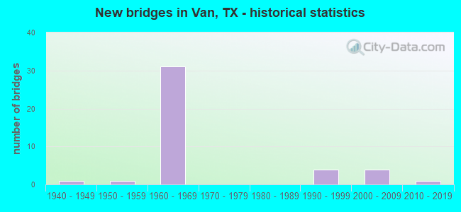
- New bridges - historical statistics
- 11940-1949
- 11950-1959
- 311960-1969
- 41990-1999
- 42000-2009
- 12010-2019

- Reconstructed bridges - Historical Statistics
- 11950-1959
- 01960-1969
- 01970-1979
- 01980-1989
- 21990-1999
- 02000-2009
- 12010-2019


- Bridge Condition - Deck
- 7.1%Very good
- 50.0%Good
- 28.6%Satisfactory
- 14.3%Fair

- Bridge Condition - Superstructure
- 28.6%Good
- 50.0%Satisfactory
- 21.4%Fair

- Bridge Condition - Substructure
- 71.4%Good
- 28.6%Satisfactory

- Bridge Condition - Channel
- 26.9%Good
- 69.2%Satisfactory
- 3.8%Fair

- Bridge Condition - Culverts
- 10.0%Good
- 80.0%Satisfactory
- 10.0%Fair
Find on map >> Show street view
Structure Number: 102120049504044, Location: 0.5 MI E OF VAN ZANDT CL (Lat: 32.498442, Lng: -95.584742), Route carried "on" structure: County highway 426, Year Built: 1961, Status: Open, Structure Length: 6.89m (22.60ft), Average Daily Traffic: 470 (year 2019), Average Future Daily Traffic: 700 (year 2039), Design Load: H 15, Features Intersected: IH 20
Minimum Vertical Clearance: 30+ m (98+ ft), Kilometerpoint: 0.805, Lanes on structure: 2, Lanes under structure: 4, Owner: State Highway Agency, Approaching Roadway Width: 7.3m (24.0ft), Skew: 1 degrees, Material/Design: Steel continuous, Design/Construction: Stringer/Multi-beam, Number Of Spans In Main Unit: 4, Length of Maximum Span: 18.9m (62.0ft), Curb-To-Curb Width: 7.1m (23.3ft), Out-to-Out Width: 7.8m (25.6ft)
Condition: Deck: Good, Superstructure: Satisfactory, Substructure: Satisfactory, Operating Rating: 44.4 metric tons, Method Used To Determine Operating Rating: Load Factor (LF), Inventory Rating: 26.3 metric tons, Method Used To Determine Inventory Rating: Load Factor (LF), Structural Evaluation: Equal to present minimum criteria, Deck Geometry: Meets minimum limits, Underclear: Meets minimum limits, Approach Roadway Alignment: Equal to present desirable criteria, Length Of Structure Improvement: 6.89m (22.60ft), Designated Inspection Frequency: Every 24 months, Inspection Date: March 2021, Bridge Improvement Cost: $10,000, Roadway Improvement Cost: $3,000, Total Project Cost: $13,000, Deck Structure Type: Concrete Cast-file-Place, Wearing Surface/Protective System: Wearing Surface: Bituminous
Find on map >> Show street view
Structure Number: 102120AA0447101, Location: 0.7 MI S OF FM 1805 (Lat: 32.555450, Lng: -95.591922), Route carried "on" structure: County highway 447, Year Built: 1995, Status: Open, Structure Length: 0.98m (3.22ft), Average Daily Traffic: 280 (year 2015), Average Future Daily Traffic: 250 (year 2035), Features Intersected: SKY LAKE HEADWATERS
Minimum Vertical Clearance: 30+ m (98+ ft), Kilometerpoint: 1.127, Lanes on structure: 2, Owner: County Highway Agency, Approaching Roadway Width: 6.1m (20.0ft), Material/Design: Steel, Design/Construction: Stringer/Multi-beam, Number Of Spans In Main Unit: 1, Length of Maximum Span: 8.5m (27.9ft), Curb-To-Curb Width: 7.4m (24.3ft), Out-to-Out Width: 7.9m (25.9ft)
Condition: Deck: Good, Superstructure: Satisfactory, Substructure: Good, Channel: Good, Operating Rating: 32.7 metric tons, Method Used To Determine Operating Rating: Field evaluation and documented engineering judgment, Inventory Rating: 24.5 metric tons, Method Used To Determine Inventory Rating: Field evaluation and documented engineering judgment, Structural Evaluation: Equal to present minimum criteria, Deck Geometry: Somewhat better than minimum adequacy, Waterway Adequacy: Better than present minimum criteria, Approach Roadway Alignment: Equal to present desirable criteria, Length Of Structure Improvement: 1.62m (5.31ft), Designated Inspection Frequency: Every 24 months, Inspection Date: October 2021, Bridge Improvement Cost: $25,000, Roadway Improvement Cost: $9,000, Total Project Cost: $34,000, Deck Structure Type: Wood or Timber, Wearing Surface/Protective System: Wearing Surface: Bituminous
Find on map >> Show street view
Structure Number: 102120AA0448001, Location: 1.15 MI W. of FM 1253 (Lat: 32.561750, Lng: -95.577739), Route carried "on" structure: County highway 448, Year Built: 2015, Status: Open, Structure Length: 1.68m (5.51ft), Average Daily Traffic: 699 (year 2020), Average Future Daily Traffic: 75 (year 2035), Design Load: HL 93, Features Intersected: VILLAGE CREEK
Minimum Vertical Clearance: 30+ m (98+ ft), Kilometerpoint: 2.012, Lanes on structure: 2, Owner: County Highway Agency, Approaching Roadway Width: 7.3m (24.0ft), Material/Design: Prestressed concrete, Design/Construction: Slab, Number Of Spans In Main Unit: 1, Length of Maximum Span: 16.8m (55.1ft), Curb-To-Curb Width: 7.3m (24.0ft), Out-to-Out Width: 7.9m (25.9ft)
Condition: Deck: Very good, Superstructure: Good, Substructure: Good, Channel: Good, Operating Rating: 54.4 metric tons, Method Used To Determine Operating Rating: Assigned ratings based on Load and Resistance Factor Design (LRFD) reported in metric tons, Inventory Rating: 32.7 metric tons, Method Used To Determine Inventory Rating: Assigned rating based on Load Factor Design (LFD) reported in metric tons, Structural Evaluation: Better than present minimum criteria, Deck Geometry: Meets minimum limits, Waterway Adequacy: Better than present minimum criteria, Approach Roadway Alignment: Equal to present desirable criteria, Designated Inspection Frequency: Every 24 months, Inspection Date: October 2021, Deck Structure Type: Concrete Cast-file-Place, Wearing Surface/Protective System: Wearing Surface: Bituminous
Find on map >> Show street view
Structure Number: 102340049503001, Location: 13.2 MI E OF SH 19 (Lat: 32.506283, Lng: -95.643206), Route carried "on" structure: State highway 314, Year Built: 2005, Status: Open, Structure Length: 7.32m (24.02ft), Average Daily Traffic: 6,110 (year 2013), Truck Traffic: 5%, Average Future Daily Traffic: 8,560 (year 2033), Design Load: HL 93, Features Intersected: IH 20
Minimum Vertical Clearance: 30+ m (98+ ft), Kilometerpoint: 1.778, Lanes on structure: 2, Lanes under structure: 4, Owner: State Highway Agency, Approaching Roadway Width: 18.3m (60.0ft), Skew: 1 degrees, Material/Design: Prestressed concrete, Design/Construction: Box Beam or Girders - Multiple, Number Of Spans In Main Unit: 2, Number Of Approach Spans: 2, Length of Maximum Span: 22.9m (75.1ft), Curb-To-Curb Width: 18.3m (60.0ft), Out-to-Out Width: 18.9m (62.0ft)
Condition: Deck: Good, Superstructure: Good, Substructure: Good, Operating Rating: 54.4 metric tons, Method Used To Determine Operating Rating: Assigned ratings based on Load and Resistance Factor Design (LRFD) reported in metric tons, Inventory Rating: 32.7 metric tons, Method Used To Determine Inventory Rating: Assigned ratings based on Load and Resistance Factor Design (LRFD) reported in metric tons, Structural Evaluation: Better than present minimum criteria, Deck Geometry: Superior to present desirable criteria, Underclear: Meets minimum limits, Approach Roadway Alignment: Equal to present desirable criteria, Designated Inspection Frequency: Every 24 months, Inspection Date: October 2020, Deck Structure Type: Concrete Cast-file-Place
Find on map >> Show street view
Structure Number: 102340049503088, Location: 0.35 MI W OF FM 16 (Lat: 32.520431, Lng: -95.701139), Route carried "on" structure: State highway 773, Year Built: 1962, Status: Open, Structure Length: 6.89m (22.60ft), Average Daily Traffic: 420 (year 2013), Truck Traffic: 9%, Average Future Daily Traffic: 590 (year 2033), Design Load: H 15, Features Intersected: IH 20
Minimum Vertical Clearance: 30+ m (98+ ft), Kilometerpoint: 9.521, Lanes on structure: 2, Lanes under structure: 4, Owner: State Highway Agency, Approaching Roadway Width: 6.7m (22.0ft), Skew: 1 degrees, Material/Design: Steel continuous, Design/Construction: Stringer/Multi-beam, Number Of Spans In Main Unit: 4, Length of Maximum Span: 18.9m (62.0ft), Curb-To-Curb Width: 7.1m (23.3ft), Out-to-Out Width: 7.8m (25.6ft)
Condition: Deck: Fair, Superstructure: Satisfactory, Substructure: Satisfactory, Operating Rating: 40.8 metric tons, Method Used To Determine Operating Rating: Load Factor (LF), Inventory Rating: 24.5 metric tons, Method Used To Determine Inventory Rating: Load Factor (LF), Structural Evaluation: Equal to present minimum criteria, Deck Geometry: Meets minimum limits, Underclear: Meets minimum limits, Approach Roadway Alignment: High priority of corrective action, Designated Inspection Frequency: Every 24 months, Inspection Date: October 2020, Deck Structure Type: Concrete Cast-file-Place, Wearing Surface/Protective System: Wearing Surface: Bituminous
Find on map >> Show street view
Structure Number: 102340049503089, Location: 0.20 MI W OF FM 16 (Lat: 32.519253, Lng: -95.696400), Route carried "on" structure: ServiceState highway 20, Year Built: 1962, Status: Open, Structure Length: 1.10m (3.61ft), Average Daily Traffic: 90 (year 2013), Truck Traffic: 22%, Average Future Daily Traffic: 120 (year 2033), Design Load: HS 20, Features Intersected: NECHES RVR TR
Minimum Vertical Clearance: 30+ m (98+ ft), Kilometerpoint: 38.664, Lanes on structure: 2, Owner: State Highway Agency, Approaching Roadway Width: 8.5m (27.9ft), Skew: 3 degrees, Material/Design: Concrete, Design/Construction: Culvert, Number Of Spans In Main Unit: 4, Length of Maximum Span: 2.1m (6.9ft)
Condition: Channel: Satisfactory, Culverts: Good, Operating Rating: 39.9 metric tons, Method Used To Determine Operating Rating: Load Factor (LF), Inventory Rating: 23.6 metric tons, Method Used To Determine Inventory Rating: Load Factor (LF), Structural Evaluation: Equal to present minimum criteria, Waterway Adequacy: Equal to present minimum criteria, Approach Roadway Alignment: Equal to present desirable criteria, Designated Inspection Frequency: Every 24 months, Inspection Date: October 2020
Find on map >> Show street view
Structure Number: 10234004950309, Location: 0.05 MI W OF FM 16 (Lat: 32.518347, Lng: -95.696583), Route carried "on" structure: Interstate 20, Year Built: 1962, Status: Open, Structure Length: 1.01m (3.31ft), Average Daily Traffic: 39,520 (year 2020), Truck Traffic: 29%, Average Future Daily Traffic: 34,850 (year 2033), Features Intersected: NECHES RVR TR
Minimum Vertical Clearance: 30+ m (98+ ft), Kilometerpoint: 38.700, Lanes on structure: 4, Owner: State Highway Agency, Approaching Roadway Width: 23.2m (76.1ft), Skew: 30 degrees, Material/Design: Concrete, Design/Construction: Culvert, Number Of Spans In Main Unit: 3, Length of Maximum Span: 3.0m (9.8ft)
Condition: Channel: Satisfactory, Culverts: Satisfactory, Operating Rating: 32.7 metric tons, Method Used To Determine Operating Rating: Field evaluation and documented engineering judgment, Inventory Rating: 24.5 metric tons, Method Used To Determine Inventory Rating: Field evaluation and documented engineering judgment, Structural Evaluation: Equal to present minimum criteria, Waterway Adequacy: Superior to present desirable criteria, Approach Roadway Alignment: Equal to present desirable criteria, Designated Inspection Frequency: Every 24 months, Inspection Date: October 2020
Find on map >> Show street view
Structure Number: 102340049503091, Location: 0.35 MI E OF FM 773 (Lat: 32.518367, Lng: -95.695772), Route carried "on" structure: Interstate 20, Year Built: 1962, Status: Open, Structure Length: 5.21m (17.09ft), Average Daily Traffic: 20,438 (year 2020), Truck Traffic: 29%, Average Future Daily Traffic: 17,420 (year 2033), Design Load: HS 20, Features Intersected: FM 16
Minimum Vertical Clearance: 30+ m (98+ ft), Kilometerpoint: 38.766, Lanes on structure: 2, Lanes under structure: 2, Base Highway Network: Yes, Owner: State Highway Agency, Approaching Roadway Width: 11.6m (38.1ft), Skew: 4 degrees, Material/Design: Steel continuous, Design/Construction: Stringer/Multi-beam, Number Of Spans In Main Unit: 3, Length of Maximum Span: 19.8m (65.0ft), Curb-To-Curb Width: 11.6m (38.1ft), Out-to-Out Width: 12.3m (40.4ft)
Condition: Deck: Satisfactory, Superstructure: Fair, Substructure: Good, Operating Rating: 43.5 metric tons, Method Used To Determine Operating Rating: Load Factor (LF), Inventory Rating: 26.3 metric tons, Method Used To Determine Inventory Rating: Load Factor (LF), Structural Evaluation: Somewhat better than minimum adequacy, Deck Geometry: Equal to present minimum criteria, Underclear: Somewhat better than minimum adequacy, Approach Roadway Alignment: Equal to present desirable criteria, Designated Inspection Frequency: Every 24 months, Inspection Date: October 2020, Deck Structure Type: Concrete Cast-file-Place, Wearing Surface/Protective System: Wearing Surface: Bituminous
Find on map >> Show street view
Structure Number: 102340049503092, Location: 0.35 MI E OF FM 773 (Lat: 32.518289, Lng: -95.696089), Route carried "on" structure: Interstate 20, Year Built: 1962, Status: Open, Structure Length: 5.21m (17.09ft), Average Daily Traffic: 19,082 (year 2020), Truck Traffic: 29%, Average Future Daily Traffic: 17,420 (year 2033), Design Load: HS 20, Features Intersected: FM 16
Minimum Vertical Clearance: 30+ m (98+ ft), Kilometerpoint: 38.753, Lanes on structure: 2, Lanes under structure: 2, Base Highway Network: Yes, Owner: State Highway Agency, Approaching Roadway Width: 11.6m (38.1ft), Skew: 4 degrees, Material/Design: Steel continuous, Design/Construction: Stringer/Multi-beam, Number Of Spans In Main Unit: 3, Length of Maximum Span: 19.8m (65.0ft), Curb-To-Curb Width: 11.6m (38.1ft), Out-to-Out Width: 12.3m (40.4ft)
Condition: Deck: Satisfactory, Superstructure: Fair, Substructure: Good, Operating Rating: 43.5 metric tons, Method Used To Determine Operating Rating: Load Factor (LF), Inventory Rating: 26.3 metric tons, Method Used To Determine Inventory Rating: Load Factor (LF), Structural Evaluation: Somewhat better than minimum adequacy, Deck Geometry: Equal to present minimum criteria, Underclear: Somewhat better than minimum adequacy, Approach Roadway Alignment: Equal to present desirable criteria, Designated Inspection Frequency: Every 24 months, Inspection Date: October 2020, Deck Structure Type: Concrete Cast-file-Place, Wearing Surface/Protective System: Wearing Surface: Bituminous
Find on map >> Show street view
Structure Number: 102340049503093, Location: 0.10 MI E OF FM 16 (Lat: 32.517333, Lng: -95.695742), Route carried "on" structure: ServiceState highway 20, Year Built: 1962, Status: Open, Structure Length: 0.98m (3.22ft), Average Daily Traffic: 190 (year 2013), Truck Traffic: 17%, Average Future Daily Traffic: 270 (year 2033), Design Load: HS 20, Features Intersected: NECHES RVR TR
Minimum Vertical Clearance: 30+ m (98+ ft), Kilometerpoint: 38.842, Lanes on structure: 2, Owner: State Highway Agency, Approaching Roadway Width: 7.9m (25.9ft), Material/Design: Concrete, Design/Construction: Culvert, Number Of Spans In Main Unit: 3, Length of Maximum Span: 3.0m (9.8ft), Curb-To-Curb Width: 8.7m (28.5ft), Out-to-Out Width: 18.1m (59.4ft)
Condition: Channel: Satisfactory, Culverts: Satisfactory, Operating Rating: 39.9 metric tons, Method Used To Determine Operating Rating: Load Factor (LF), Inventory Rating: 23.6 metric tons, Method Used To Determine Inventory Rating: Load Factor (LF), Structural Evaluation: Equal to present minimum criteria, Deck Geometry: Equal to present minimum criteria, Waterway Adequacy: Equal to present minimum criteria, Approach Roadway Alignment: Equal to present desirable criteria, Designated Inspection Frequency: Every 24 months, Inspection Date: October 2020, Deck Structure Type: Concrete Cast-file-Place, Wearing Surface/Protective System: Wearing Surface: Bituminous
Find on map >> Show street view
Structure Number: 102340049503094, Location: 1.10 MI E OF FM 16 (Lat: 32.512883, Lng: -95.678983), Route carried "on" structure: Interstate 20, Year Built: 1962, Status: Open, Structure Length: 0.67m (2.20ft), Average Daily Traffic: 37,081 (year 2020), Truck Traffic: 30%, Average Future Daily Traffic: 41,860 (year 2033), Design Load: HS 20, Features Intersected: NECHES RVR TR
Minimum Vertical Clearance: 30+ m (98+ ft), Kilometerpoint: 40.467, Lanes on structure: 4, Base Highway Network: Yes, Owner: State Highway Agency, Approaching Roadway Width: 23.2m (76.1ft), Skew: 20 degrees, Material/Design: Concrete, Design/Construction: Culvert, Number Of Spans In Main Unit: 2, Length of Maximum Span: 3.0m (9.8ft), Curb-To-Curb Width: 23.2m (76.1ft), Out-to-Out Width: 40.6m (133.2ft)
Condition: Channel: Good, Culverts: Satisfactory, Operating Rating: 39.9 metric tons, Method Used To Determine Operating Rating: Load Factor (LF), Inventory Rating: 23.6 metric tons, Method Used To Determine Inventory Rating: Load Factor (LF), Structural Evaluation: Somewhat better than minimum adequacy, Deck Geometry: Superior to present desirable criteria, Waterway Adequacy: Equal to present minimum criteria, Approach Roadway Alignment: Equal to present desirable criteria, Designated Inspection Frequency: Every 24 months, Inspection Date: October 2020, Deck Structure Type: Concrete Cast-file-Place, Wearing Surface/Protective System: Wearing Surface: Bituminous
Find on map >> Show street view
Structure Number: 102340049503095, Location: 1.30 MI E OF FM 16 (Lat: 32.512389, Lng: -95.674908), Route carried "on" structure: Interstate 20, Year Built: 1962, Status: Open, Structure Length: 3.87m (12.70ft), Average Daily Traffic: 17,651 (year 2020), Truck Traffic: 30%, Average Future Daily Traffic: 20,930 (year 2033), Design Load: HS 20, Features Intersected: CR 4517
Minimum Vertical Clearance: 30+ m (98+ ft), Kilometerpoint: 40.852, Lanes on structure: 2, Lanes under structure: 2, Base Highway Network: Yes, Owner: State Highway Agency, Approaching Roadway Width: 11.6m (38.1ft), Skew: 1 degrees, Material/Design: Steel continuous, Design/Construction: Stringer/Multi-beam, Number Of Spans In Main Unit: 3, Length of Maximum Span: 13.7m (44.9ft), Curb-To-Curb Width: 11.6m (38.1ft), Out-to-Out Width: 12.3m (40.4ft)
Condition: Deck: Satisfactory, Superstructure: Satisfactory, Substructure: Good, Operating Rating: 48.1 metric tons, Method Used To Determine Operating Rating: Load Factor (LF), Inventory Rating: 29.0 metric tons, Method Used To Determine Inventory Rating: Load Factor (LF), Structural Evaluation: Equal to present minimum criteria, Deck Geometry: Equal to present minimum criteria, Underclear: Meets minimum limits, Approach Roadway Alignment: Equal to present desirable criteria, Designated Inspection Frequency: Every 24 months, Inspection Date: October 2020, Deck Structure Type: Concrete Cast-file-Place, Wearing Surface/Protective System: Wearing Surface: Bituminous
Find on map >> Show street view
Structure Number: 102340049503096, Location: 1.30 MI E OF FM 16 (Lat: 32.512186, Lng: -95.674906), Route carried "on" structure: Interstate 20, Year Built: 1962, Status: Open, Structure Length: 3.87m (12.70ft), Average Daily Traffic: 19,430 (year 2020), Truck Traffic: 30%, Average Future Daily Traffic: 20,930 (year 2033), Design Load: HS 20, Features Intersected: CR 4517
Minimum Vertical Clearance: 30+ m (98+ ft), Kilometerpoint: 40.855, Lanes on structure: 2, Lanes under structure: 2, Base Highway Network: Yes, Owner: State Highway Agency, Approaching Roadway Width: 11.6m (38.1ft), Skew: 1 degrees, Material/Design: Steel continuous, Design/Construction: Stringer/Multi-beam, Number Of Spans In Main Unit: 3, Length of Maximum Span: 13.7m (44.9ft), Curb-To-Curb Width: 11.6m (38.1ft), Out-to-Out Width: 12.3m (40.4ft)
Condition: Deck: Satisfactory, Superstructure: Fair, Substructure: Good, Operating Rating: 48.1 metric tons, Method Used To Determine Operating Rating: Load Factor (LF), Inventory Rating: 29.0 metric tons, Method Used To Determine Inventory Rating: Load Factor (LF), Structural Evaluation: Somewhat better than minimum adequacy, Deck Geometry: Equal to present minimum criteria, Underclear: Somewhat better than minimum adequacy, Approach Roadway Alignment: Equal to present desirable criteria, Designated Inspection Frequency: Every 24 months, Inspection Date: October 2020, Deck Structure Type: Concrete Cast-file-Place, Wearing Surface/Protective System: Wearing Surface: Bituminous
Find on map >> Show street view
Structure Number: 102340049503097, Location: 1.00 MI W OF FM 314 (Lat: 32.510033, Lng: -95.660269), Route carried "on" structure: ServiceState highway 20, Year Built: 1962, Status: Open, Structure Length: 0.98m (3.22ft), Average Daily Traffic: 250 (year 2013), Truck Traffic: 30%, Average Future Daily Traffic: 350 (year 2033), Design Load: HS 20, Features Intersected: NECHES RVR TR
Minimum Vertical Clearance: 30+ m (98+ ft), Kilometerpoint: 42.252, Lanes on structure: 2, Owner: State Highway Agency, Approaching Roadway Width: 6.1m (20.0ft), Material/Design: Concrete, Design/Construction: Culvert, Number Of Spans In Main Unit: 3, Length of Maximum Span: 3.0m (9.8ft), Curb-To-Curb Width: 10.4m (34.1ft), Out-to-Out Width: 10.8m (35.4ft)
Condition: Channel: Satisfactory, Culverts: Satisfactory, Operating Rating: 39.9 metric tons, Method Used To Determine Operating Rating: Load Factor (LF), Inventory Rating: 23.6 metric tons, Method Used To Determine Inventory Rating: Load Factor (LF), Structural Evaluation: Equal to present minimum criteria, Deck Geometry: Better than present minimum criteria, Waterway Adequacy: Equal to present minimum criteria, Approach Roadway Alignment: Equal to present desirable criteria, Designated Inspection Frequency: Every 24 months, Inspection Date: October 2020, Deck Structure Type: Concrete Cast-file-Place, Wearing Surface/Protective System: Wearing Surface: Bituminous
Find on map >> Show street view
Structure Number: 102340049503098, Location: 1.0 MI W OF FM 314 (Lat: 32.509542, Lng: -95.660411), Route carried "on" structure: Interstate 20, Year Built: 1962, Status: Open, Structure Length: 1.31m (4.30ft), Average Daily Traffic: 37,081 (year 2020), Truck Traffic: 30%, Average Future Daily Traffic: 41,860 (year 2033), Design Load: HS 20, Features Intersected: NECHES RIVER TRIB
Minimum Vertical Clearance: 30+ m (98+ ft), Kilometerpoint: 42.252, Lanes on structure: 4, Base Highway Network: Yes, Owner: State Highway Agency, Approaching Roadway Width: 23.2m (76.1ft), Skew: 20 degrees, Material/Design: Concrete, Design/Construction: Culvert, Number Of Spans In Main Unit: 4, Length of Maximum Span: 3.0m (9.8ft)
Condition: Channel: Good, Culverts: Satisfactory, Operating Rating: 39.9 metric tons, Method Used To Determine Operating Rating: Load Factor (LF), Inventory Rating: 23.6 metric tons, Method Used To Determine Inventory Rating: Load Factor (LF), Structural Evaluation: Somewhat better than minimum adequacy, Waterway Adequacy: Equal to present minimum criteria, Approach Roadway Alignment: Equal to present desirable criteria, Designated Inspection Frequency: Every 24 months, Inspection Date: October 2020
Find on map >> Show street view
Structure Number: 102340049503099, Location: 1.0 MI W OF FM 314 (Lat: 32.509283, Lng: -95.660461), Route carried "on" structure: ServiceState highway 20, Year Built: 1962, Status: Open, Structure Length: 0.98m (3.22ft), Average Daily Traffic: 190 (year 2013), Truck Traffic: 17%, Average Future Daily Traffic: 270 (year 2033), Design Load: HS 20, Features Intersected: NECHES RIVER TRIB
Minimum Vertical Clearance: 30+ m (98+ ft), Kilometerpoint: 42.252, Lanes on structure: 2, Owner: State Highway Agency, Approaching Roadway Width: 4.9m (16.1ft), Material/Design: Concrete, Design/Construction: Culvert, Number Of Spans In Main Unit: 3, Length of Maximum Span: 3.0m (9.8ft)
Condition: Channel: Satisfactory, Culverts: Satisfactory, Operating Rating: 39.9 metric tons, Method Used To Determine Operating Rating: Load Factor (LF), Inventory Rating: 23.6 metric tons, Method Used To Determine Inventory Rating: Load Factor (LF), Structural Evaluation: Equal to present minimum criteria, Waterway Adequacy: Equal to present minimum criteria, Approach Roadway Alignment: Equal to present desirable criteria, Designated Inspection Frequency: Every 24 months, Inspection Date: October 2020
Find on map >> Show street view
Structure Number: 1023400495031, Location: 0.85 MI W OF FM 314 (Lat: 32.509144, Lng: -95.658222), Route carried "on" structure: Interstate 20, Year Built: 1962, Status: Open, Structure Length: 0.67m (2.20ft), Average Daily Traffic: 37,081 (year 2020), Truck Traffic: 30%, Average Future Daily Traffic: 41,860 (year 2033), Design Load: HS 20, Features Intersected: NECHES RVR TR
Minimum Vertical Clearance: 30+ m (98+ ft), Kilometerpoint: 42.461, Lanes on structure: 4, Base Highway Network: Yes, Owner: State Highway Agency, Approaching Roadway Width: 23.2m (76.1ft), Skew: 20 degrees, Material/Design: Concrete, Design/Construction: Culvert, Number Of Spans In Main Unit: 2, Length of Maximum Span: 3.0m (9.8ft)
Condition: Channel: Good, Culverts: Satisfactory, Operating Rating: 32.7 metric tons, Method Used To Determine Operating Rating: Field evaluation and documented engineering judgment, Inventory Rating: 24.5 metric tons, Method Used To Determine Inventory Rating: Field evaluation and documented engineering judgment, Structural Evaluation: Equal to present minimum criteria, Waterway Adequacy: Equal to present minimum criteria, Approach Roadway Alignment: Equal to present desirable criteria, Designated Inspection Frequency: Every 24 months, Inspection Date: October 2020
Find on map >> Show street view
Structure Number: 102340049503102, Location: 0.7 MI E OF FM 314 (Lat: 32.504208, Lng: -95.631736), Route carried "on" structure: ServiceState highway 20, Year Built: 1962, Year Reconstructed: 2017, Status: Open, Structure Length: 1.31m (4.30ft), Average Daily Traffic: 250 (year 2013), Truck Traffic: 30%, Average Future Daily Traffic: 350 (year 2033), Features Intersected: BIG SANDY CREEK
Minimum Vertical Clearance: 30+ m (98+ ft), Kilometerpoint: 45.009, Lanes on structure: 2, Owner: State Highway Agency, Approaching Roadway Width: 9.1m (29.9ft), Material/Design: Concrete, Design/Construction: Culvert, Number Of Spans In Main Unit: 4, Length of Maximum Span: 3.0m (9.8ft), Curb-To-Curb Width: 17.3m (56.8ft), Out-to-Out Width: 17.7m (58.1ft)
Condition: Channel: Satisfactory, Culverts: Satisfactory, Operating Rating: 32.7 metric tons, Method Used To Determine Operating Rating: Field evaluation and documented engineering judgment, Inventory Rating: 24.5 metric tons, Method Used To Determine Inventory Rating: Field evaluation and documented engineering judgment, Structural Evaluation: Equal to present minimum criteria, Deck Geometry: Superior to present desirable criteria, Waterway Adequacy: Equal to present minimum criteria, Approach Roadway Alignment: Equal to present desirable criteria, Designated Inspection Frequency: Every 24 months, Inspection Date: October 2020, Deck Structure Type: Concrete Cast-file-Place, Wearing Surface/Protective System: Wearing Surface: Monolithic Concrete
Find on map >> Show street view
Structure Number: 102340049503103, Location: 0.7 MI E OF FM 314 (Lat: 32.503597, Lng: -95.632025), Route carried "on" structure: Interstate 20, Year Built: 1962, Year Reconstructed: 1998, Status: Open, Structure Length: 1.65m (5.41ft), Average Daily Traffic: 37,081 (year 2020), Truck Traffic: 30%, Average Future Daily Traffic: 41,860 (year 2033), Design Load: HS 20, Features Intersected: BIG SANDY CREEK
Minimum Vertical Clearance: 30+ m (98+ ft), Kilometerpoint: 45.009, Lanes on structure: 4, Base Highway Network: Yes, Owner: State Highway Agency, Approaching Roadway Width: 23.2m (76.1ft), Skew: 20 degrees, Material/Design: Concrete, Design/Construction: Culvert, Number Of Spans In Main Unit: 5, Length of Maximum Span: 3.0m (9.8ft)
Condition: Channel: Satisfactory, Culverts: Satisfactory, Operating Rating: 39.9 metric tons, Method Used To Determine Operating Rating: Load Factor (LF), Inventory Rating: 23.6 metric tons, Method Used To Determine Inventory Rating: Load Factor (LF), Structural Evaluation: Somewhat better than minimum adequacy, Waterway Adequacy: Equal to present minimum criteria, Approach Roadway Alignment: Equal to present desirable criteria, Designated Inspection Frequency: Every 24 months, Inspection Date: October 2020
Find on map >> Show street view
Structure Number: 102340049503105, Location: 1.05 MI E OF FM 314 (Lat: 32.502411, Lng: -95.625758), Route carried "on" structure: ServiceState highway 20, Year Built: 1962, Status: Open, Structure Length: 0.98m (3.22ft), Average Daily Traffic: 250 (year 2013), Truck Traffic: 30%, Average Future Daily Traffic: 350 (year 2033), Design Load: HS 20, Features Intersected: BIG SANDY CREEK TRIB
Minimum Vertical Clearance: 30+ m (98+ ft), Kilometerpoint: 45.604, Lanes on structure: 2, Owner: State Highway Agency, Approaching Roadway Width: 6.7m (22.0ft), Material/Design: Concrete, Design/Construction: Culvert, Number Of Spans In Main Unit: 3, Length of Maximum Span: 3.0m (9.8ft), Curb-To-Curb Width: 8.2m (26.9ft), Out-to-Out Width: 9.8m (32.2ft)
Condition: Channel: Satisfactory, Culverts: Satisfactory, Operating Rating: 39.9 metric tons, Method Used To Determine Operating Rating: Load Factor (LF), Inventory Rating: 23.6 metric tons, Method Used To Determine Inventory Rating: Load Factor (LF), Structural Evaluation: Equal to present minimum criteria, Deck Geometry: Somewhat better than minimum adequacy, Waterway Adequacy: Equal to present minimum criteria, Approach Roadway Alignment: Equal to present desirable criteria, Length Of Structure Improvement: 0.94m (3.08ft), Designated Inspection Frequency: Every 24 months, Inspection Date: October 2020, Bridge Improvement Cost: $12,000, Roadway Improvement Cost: $3,000, Total Project Cost: $15,000, Deck Structure Type: Concrete Cast-file-Place, Wearing Surface/Protective System: Wearing Surface: Bituminous
Find on map >> Show street view
Structure Number: 102340049503106, Location: 1.05 MI E OF FM 314 (Lat: 32.501728, Lng: -95.626075), Route carried "on" structure: Interstate 20, Year Built: 1962, Year Reconstructed: 1997, Status: Open, Structure Length: 1.31m (4.30ft), Average Daily Traffic: 37,081 (year 2020), Truck Traffic: 30%, Average Future Daily Traffic: 41,860 (year 2033), Design Load: HS 20, Features Intersected: BIG SANDY CREEK TRIB
Minimum Vertical Clearance: 30+ m (98+ ft), Kilometerpoint: 45.604, Lanes on structure: 5, Base Highway Network: Yes, Owner: State Highway Agency, Approaching Roadway Width: 23.2m (76.1ft), Skew: 20 degrees, Material/Design: Concrete, Design/Construction: Culvert, Number Of Spans In Main Unit: 4, Length of Maximum Span: 3.0m (9.8ft)
Condition: Channel: Satisfactory, Culverts: Satisfactory, Operating Rating: 39.9 metric tons, Method Used To Determine Operating Rating: Load Factor (LF), Inventory Rating: 23.6 metric tons, Method Used To Determine Inventory Rating: Load Factor (LF), Structural Evaluation: Somewhat better than minimum adequacy, Waterway Adequacy: Equal to present minimum criteria, Approach Roadway Alignment: Equal to present desirable criteria, Designated Inspection Frequency: Every 24 months, Inspection Date: October 2020
Find on map >> Show street view
Structure Number: 102340049503108, Location: 1.95 MI E OF FM 314 (Lat: 32.499853, Lng: -95.610625), Route carried "on" structure: County highway 4930, Year Built: 1962, Status: Open, Structure Length: 6.61m (21.69ft), Average Daily Traffic: 20 (year 2010), Truck Traffic: 5%, Average Future Daily Traffic: 50 (year 2030), Design Load: H 15, Features Intersected: IH 20
Minimum Vertical Clearance: 30+ m (98+ ft), Kilometerpoint: 0.805, Lanes on structure: 2, Lanes under structure: 4, Owner: State Highway Agency, Approaching Roadway Width: 6.7m (22.0ft), Material/Design: Steel continuous, Design/Construction: Stringer/Multi-beam, Number Of Spans In Main Unit: 4, Length of Maximum Span: 18.3m (60.0ft), Curb-To-Curb Width: 7.1m (23.3ft), Out-to-Out Width: 7.8m (25.6ft)
Condition: Deck: Fair, Superstructure: Satisfactory, Substructure: Good, Operating Rating: 44.4 metric tons, Method Used To Determine Operating Rating: Load Factor (LF), Inventory Rating: 26.3 metric tons, Method Used To Determine Inventory Rating: Load Factor (LF), Structural Evaluation: Equal to present minimum criteria, Deck Geometry: Somewhat better than minimum adequacy, Underclear: Meets minimum limits, Approach Roadway Alignment: Equal to present desirable criteria, Length Of Structure Improvement: 7.62m (25.00ft), Designated Inspection Frequency: Every 24 months, Inspection Date: October 2020, Bridge Improvement Cost: $625,000, Roadway Improvement Cost: $175,000, Total Project Cost: $800,000, Deck Structure Type: Concrete Cast-file-Place
Find on map >> Show street view
Structure Number: 102340049503109, Location: 2.75 MI E OF FM 314 (Lat: 32.499950, Lng: -95.597131), Route carried "on" structure: ServiceState highway 20, Year Built: 1962, Status: Open, Structure Length: 1.31m (4.30ft), Average Daily Traffic: 250 (year 2013), Truck Traffic: 30%, Average Future Daily Traffic: 350 (year 2033), Design Load: HS 20, Features Intersected: LITTLE SANDY CREEK
Minimum Vertical Clearance: 30+ m (98+ ft), Kilometerpoint: 48.332, Lanes on structure: 2, Owner: State Highway Agency, Approaching Roadway Width: 6.1m (20.0ft), Material/Design: Concrete, Design/Construction: Culvert, Number Of Spans In Main Unit: 4, Length of Maximum Span: 3.0m (9.8ft), Curb-To-Curb Width: 6.1m (20.0ft), Out-to-Out Width: 10.8m (35.4ft)
Condition: Channel: Satisfactory, Culverts: Satisfactory, Operating Rating: 39.9 metric tons, Method Used To Determine Operating Rating: Load Factor (LF), Inventory Rating: 23.6 metric tons, Method Used To Determine Inventory Rating: Load Factor (LF), Structural Evaluation: Equal to present minimum criteria, Deck Geometry: Meets minimum limits, Waterway Adequacy: Better than present minimum criteria, Approach Roadway Alignment: Equal to present desirable criteria, Designated Inspection Frequency: Every 24 months, Inspection Date: October 2020, Deck Structure Type: Concrete Cast-file-Place, Wearing Surface/Protective System: Wearing Surface: Bituminous
Find on map >> Show street view
Structure Number: 10234004950311, Location: 2.75 MI E OF FM 314 (Lat: 32.499433, Lng: -95.597161), Route carried "on" structure: Interstate 20, Year Built: 1962, Status: Open, Structure Length: 1.65m (5.41ft), Average Daily Traffic: 37,081 (year 2020), Truck Traffic: 30%, Average Future Daily Traffic: 41,860 (year 2033), Design Load: HS 20, Features Intersected: LITTLE SANDY CREEK
Minimum Vertical Clearance: 30+ m (98+ ft), Kilometerpoint: 48.330, Lanes on structure: 4, Base Highway Network: Yes, Owner: State Highway Agency, Approaching Roadway Width: 24.4m (80.1ft), Skew: 30 degrees, Material/Design: Concrete, Design/Construction: Culvert, Number Of Spans In Main Unit: 5, Length of Maximum Span: 3.0m (9.8ft), Curb-To-Curb Width: 24.4m (80.1ft), Out-to-Out Width: 43.7m (143.4ft)
Condition: Channel: Satisfactory, Culverts: Fair, Operating Rating: 39.9 metric tons, Method Used To Determine Operating Rating: Load Factor (LF), Inventory Rating: 23.6 metric tons, Method Used To Determine Inventory Rating: Load Factor (LF), Structural Evaluation: Somewhat better than minimum adequacy, Deck Geometry: Superior to present desirable criteria, Waterway Adequacy: Superior to present desirable criteria, Approach Roadway Alignment: Equal to present desirable criteria, Designated Inspection Frequency: Every 24 months, Inspection Date: October 2020, Deck Structure Type: Concrete Cast-file-Place, Wearing Surface/Protective System: Wearing Surface: Bituminous
Find on map >> Show street view
Structure Number: 10234005050102, Location: 9.13 MI S OF US 80 (Lat: 32.564358, Lng: -95.640450), Route carried "on" structure: State highway 110, Year Built: 1957, Status: Open, Structure Length: 0.94m (3.08ft), Average Daily Traffic: 1,834 (year 2020), Truck Traffic: 9%, Average Future Daily Traffic: 2,970 (year 2033), Features Intersected: COON CREEK TRIB
Minimum Vertical Clearance: 30+ m (98+ ft), Kilometerpoint: 14.692, Lanes on structure: 2, Owner: State Highway Agency, Approaching Roadway Width: 7.3m (24.0ft), Material/Design: Concrete, Design/Construction: Culvert, Number Of Spans In Main Unit: 3, Length of Maximum Span: 3.0m (9.8ft)
Condition: Channel: Satisfactory, Culverts: Satisfactory, Operating Rating: 32.7 metric tons, Method Used To Determine Operating Rating: Field evaluation and documented engineering judgment, Inventory Rating: 24.5 metric tons, Method Used To Determine Inventory Rating: Field evaluation and documented engineering judgment, Structural Evaluation: Equal to present minimum criteria, Waterway Adequacy: Equal to present minimum criteria, Approach Roadway Alignment: Equal to present minimum criteria, Length Of Structure Improvement: 0.94m (3.08ft), Designated Inspection Frequency: Every 24 months, Inspection Date: October 2020, Bridge Improvement Cost: $14,000, Roadway Improvement Cost: $4,000, Total Project Cost: $18,000
Find on map >> Show street view
Structure Number: 102340052203036, Location: 0.05 MI SW OF IH 20 (Lat: 32.517961, Lng: -95.696503), Route carried "on" structure: State highway 16, Year Built: 1941, Year Reconstructed: 1962, Status: Open, Structure Length: 0.98m (3.22ft), Average Daily Traffic: 1,654 (year 2020), Truck Traffic: 7%, Average Future Daily Traffic: 2,020 (year 2033), Features Intersected: DRAIN
Minimum Vertical Clearance: 30+ m (98+ ft), Kilometerpoint: 10.131, Lanes on structure: 2, Owner: State Highway Agency, Approaching Roadway Width: 6.7m (22.0ft), Material/Design: Concrete, Design/Construction: Culvert, Number Of Spans In Main Unit: 4, Length of Maximum Span: 2.1m (6.9ft), Curb-To-Curb Width: 7.7m (25.3ft), Out-to-Out Width: 12.4m (40.7ft)
Condition: Channel: Satisfactory, Culverts: Satisfactory, Operating Rating: 32.7 metric tons, Method Used To Determine Operating Rating: Field evaluation and documented engineering judgment, Inventory Rating: 24.5 metric tons, Method Used To Determine Inventory Rating: Field evaluation and documented engineering judgment, Structural Evaluation: Equal to present minimum criteria, Deck Geometry: Meets minimum limits, Waterway Adequacy: Equal to present minimum criteria, Approach Roadway Alignment: Equal to present desirable criteria, Designated Inspection Frequency: Every 24 months, Inspection Date: October 2020, Deck Structure Type: Concrete Cast-file-Place, Wearing Surface/Protective System: Wearing Surface: Bituminous
Find on map >> Show street view
Structure Number: 102340074501016, Location: 0.85 MI S OF IH 20 (Lat: 32.493575, Lng: -95.643231), Route carried "on" structure: State highway 314, Year Built: 1993, Status: Open, Structure Length: 3.66m (12.01ft), Average Daily Traffic: 2,472 (year 2020), Truck Traffic: 6%, Average Future Daily Traffic: 3,670 (year 2033), Design Load: HS 20, Features Intersected: NECHES RIVER RELIEF
Minimum Vertical Clearance: 30+ m (98+ ft), Kilometerpoint: 3.331, Lanes on structure: 2, Owner: State Highway Agency, Approaching Roadway Width: 7.3m (24.0ft), Material/Design: Concrete, Design/Construction: Stringer/Multi-beam, Number Of Spans In Main Unit: 3, Length of Maximum Span: 12.2m (40.0ft), Curb-To-Curb Width: 12.2m (40.0ft), Out-to-Out Width: 13.0m (42.7ft)
Condition: Deck: Good, Superstructure: Good, Substructure: Good, Channel: Good, Operating Rating: 68.0 metric tons, Method Used To Determine Operating Rating: Load Factor (LF), Inventory Rating: 40.8 metric tons, Method Used To Determine Inventory Rating: Load Factor (LF), Structural Evaluation: Better than present minimum criteria, Deck Geometry: Equal to present minimum criteria, Waterway Adequacy: Superior to present desirable criteria, Approach Roadway Alignment: Equal to present desirable criteria, Designated Inspection Frequency: Every 24 months, Inspection Date: October 2020, Deck Structure Type: Concrete Cast-file-Place
Find on map >> Show street view
Structure Number: 102340074501017, Location: 1.00 MI S OF IH 20 (Lat: 32.491328, Lng: -95.643219), Route carried "on" structure: State highway 314, Year Built: 1993, Status: Open, Structure Length: 6.10m (20.01ft), Average Daily Traffic: 2,472 (year 2020), Truck Traffic: 6%, Average Future Daily Traffic: 3,670 (year 2033), Design Load: HS 20, Features Intersected: NECHES RIVER
Minimum Vertical Clearance: 30+ m (98+ ft), Kilometerpoint: 3.550, Lanes on structure: 2, Owner: State Highway Agency, Approaching Roadway Width: 7.3m (24.0ft), Material/Design: Concrete, Design/Construction: Stringer/Multi-beam, Number Of Spans In Main Unit: 5, Length of Maximum Span: 12.2m (40.0ft), Curb-To-Curb Width: 12.2m (40.0ft), Out-to-Out Width: 13.0m (42.7ft)
Condition: Deck: Good, Superstructure: Good, Substructure: Good, Channel: Satisfactory, Operating Rating: 68.0 metric tons, Method Used To Determine Operating Rating: Load Factor (LF), Inventory Rating: 40.8 metric tons, Method Used To Determine Inventory Rating: Load Factor (LF), Structural Evaluation: Better than present minimum criteria, Deck Geometry: Equal to present minimum criteria, Waterway Adequacy: Superior to present desirable criteria, Approach Roadway Alignment: Equal to present desirable criteria, Designated Inspection Frequency: Every 24 months, Inspection Date: October 2020, Deck Structure Type: Concrete Cast-file-Place
Find on map >> Show street view
Structure Number: 102340109904007, Location: 0.05 MI S OF FM 1995 (Lat: 32.506111, Lng: -95.700869), Route carried "on" structure: State highway 773, Year Built: 1961, Status: Open, Structure Length: 1.28m (4.20ft), Average Daily Traffic: 1,176 (year 2018), Truck Traffic: 10%, Average Future Daily Traffic: 1,880 (year 2033), Features Intersected: NECHES RIVER
Minimum Vertical Clearance: 30+ m (98+ ft), Kilometerpoint: 11.156, Lanes on structure: 2, Owner: State Highway Agency, Approaching Roadway Width: 8.2m (26.9ft), Material/Design: Concrete, Design/Construction: Culvert, Number Of Spans In Main Unit: 4, Length of Maximum Span: 3.0m (9.8ft), Curb-To-Curb Width: 8.3m (27.2ft), Out-to-Out Width: 10.8m (35.4ft)
Condition: Channel: Good, Culverts: Fair, Operating Rating: 39.9 metric tons, Method Used To Determine Operating Rating: Load Factor (LF), Inventory Rating: 23.6 metric tons, Method Used To Determine Inventory Rating: Load Factor (LF), Structural Evaluation: Somewhat better than minimum adequacy, Deck Geometry: Meets minimum limits, Waterway Adequacy: Equal to present minimum criteria, Approach Roadway Alignment: Equal to present desirable criteria, Designated Inspection Frequency: Every 24 months, Inspection Date: October 2020, Deck Structure Type: Concrete Cast-file-Place, Wearing Surface/Protective System: Wearing Surface: Bituminous
Find on map >> Show street view
Structure Number: 102340191301005, Location: 1.05 MI E OF FM 314 (Lat: 32.494603, Lng: -95.625886), Route carried "on" structure: State highway 1995, Year Built: 1961, Status: Open, Structure Length: 1.01m (3.31ft), Average Daily Traffic: 541 (year 2020), Truck Traffic: 9%, Average Future Daily Traffic: 510 (year 2033), Features Intersected: BIG SANDY CREEK
Minimum Vertical Clearance: 30+ m (98+ ft), Kilometerpoint: 12.798, Lanes on structure: 2, Owner: State Highway Agency, Approaching Roadway Width: 5.8m (19.0ft), Material/Design: Concrete, Design/Construction: Culvert, Number Of Spans In Main Unit: 3, Length of Maximum Span: 3.0m (9.8ft)
Condition: Channel: Satisfactory, Culverts: Satisfactory, Operating Rating: 39.9 metric tons, Method Used To Determine Operating Rating: Load Factor (LF), Inventory Rating: 23.6 metric tons, Method Used To Determine Inventory Rating: Load Factor (LF), Structural Evaluation: Equal to present minimum criteria, Waterway Adequacy: Better than present minimum criteria, Approach Roadway Alignment: Equal to present desirable criteria, Designated Inspection Frequency: Every 24 months, Inspection Date: October 2020
Find on map >> Show street view
Structure Number: 102340AA1507101, Location: 1.15 MI E OF FM 773 (Lat: 32.568378, Lng: -95.672422), Route carried "on" structure: County highway 1507, Year Built: 2003, Status: Open, Structure Length: 1.37m (4.49ft), Average Daily Traffic: 322 (year 2018), Average Future Daily Traffic: 240 (year 2028), Features Intersected: DRY CREEK
Minimum Vertical Clearance: 30+ m (98+ ft), Kilometerpoint: 2.736, Lanes on structure: 2, Owner: County Highway Agency, Approaching Roadway Width: 4.3m (14.1ft), Material/Design: Steel, Design/Construction: Stringer/Multi-beam, Number Of Spans In Main Unit: 1, Length of Maximum Span: 13.4m (44.0ft), Curb-To-Curb Width: 7.2m (23.6ft), Out-to-Out Width: 7.3m (24.0ft)
Condition: Deck: Good, Superstructure: Satisfactory, Substructure: Satisfactory, Channel: Fair, Operating Rating: 47.2 metric tons, Method Used To Determine Operating Rating: Allowable Stress (AS), Inventory Rating: 30.8 metric tons, Method Used To Determine Inventory Rating: Allowable Stress (AS), Structural Evaluation: Equal to present minimum criteria, Deck Geometry: Meets minimum limits, Waterway Adequacy: Better than present minimum criteria, Approach Roadway Alignment: Equal to present desirable criteria, Designated Inspection Frequency: Every 24 months, Inspection Date: September 2021, Deck Structure Type: Concrete Cast-file-Place
Find on map >> Show street view
Structure Number: 102340AA4511101, Location: 0.85 MI S OF FM 1995 (Lat: 32.490425, Lng: -95.663447), Route carried "on" structure: County highway 4511, Year Built: 2001, Status: Posted for load, Structure Length: 1.43m (4.69ft), Average Daily Traffic: 140 (year 2015), Average Future Daily Traffic: 160 (year 2035), Features Intersected: NECHES RIVER
Minimum Vertical Clearance: 30+ m (98+ ft), Kilometerpoint: 3.943, Lanes on structure: 2, Owner: County Highway Agency, Approaching Roadway Width: 4.9m (16.1ft), Material/Design: Steel continuous, Design/Construction: Stringer/Multi-beam, Number Of Spans In Main Unit: 2, Length of Maximum Span: 9.1m (29.9ft), Curb-To-Curb Width: 7.2m (23.6ft), Out-to-Out Width: 7.3m (24.0ft)
Condition: Deck: Good, Superstructure: Satisfactory, Substructure: Satisfactory, Channel: Satisfactory, Operating Rating: 20.9 metric tons, Method Used To Determine Operating Rating: Allowable Stress (AS), Inventory Rating: 12.7 metric tons, Method Used To Determine Inventory Rating: Allowable Stress (AS), Structural Evaluation: Meets minimum limits, Deck Geometry: Meets minimum limits, Waterway Adequacy: Meets minimum limits, Approach Roadway Alignment: Better than present minimum criteria, Bridge Posting: Required (Relationship of Operating Rating to Maximum Legal Load: > 39.9% below), Length Of Structure Improvement: 1.46m (4.79ft), Designated Inspection Frequency: Every 24 months, Critical Feature Inspection Frequency: Every 24 months, Inspection Date: September 2021, Critical Feature Inspection Date: Febuary 2021, Bridge Improvement Cost: $23,000, Roadway Improvement Cost: $9,000, Total Project Cost: $32,000, Deck Structure Type: Concrete Cast-file-Place
Find on map >> Show street view
Structure Number: 102340F00190001, Location: 0.05 MI N OF FM 16 (Lat: 32.524886, Lng: -95.639942), Route carried "on" structure: City street , Year Built: 1996, Status: Open, Structure Length: 0.94m (3.08ft), Average Daily Traffic: 200 (year 2009), Average Future Daily Traffic: 275 (year 2028), Features Intersected: BIG SANDY CREEK, Facility Carried by Structure: N WALNUT ST
Minimum Vertical Clearance: 30+ m (98+ ft), Kilometerpoint: 0.161, Lanes on structure: 2, Owner: City or Municipal Highway Agency, Approaching Roadway Width: 10.7m (35.1ft), Skew: 3 degrees, Material/Design: Concrete, Design/Construction: Culvert, Number Of Spans In Main Unit: 3, Length of Maximum Span: 2.4m (7.9ft), Curb-To-Curb Width: 10.6m (34.8ft), Out-to-Out Width: 13.8m (45.3ft)
Condition: Channel: Satisfactory, Culverts: Good, Operating Rating: 32.7 metric tons, Method Used To Determine Operating Rating: Field evaluation and documented engineering judgment, Inventory Rating: 24.5 metric tons, Method Used To Determine Inventory Rating: Field evaluation and documented engineering judgment, Structural Evaluation: Equal to present minimum criteria, Deck Geometry: Better than present minimum criteria, Waterway Adequacy: Better than present minimum criteria, Approach Roadway Alignment: Equal to present desirable criteria, Designated Inspection Frequency: Every 24 months, Inspection Date: September 2021, Deck Structure Type: Concrete Cast-file-Place, Wearing Surface/Protective System: Wearing Surface: Bituminous
Find on map >> Show street view
Structure Number: 102340F00195001, Location: 0.10 MI S OF FM 16 (Lat: 32.522689, Lng: -95.637975), Route carried "on" structure: City street , Year Built: 1965, Status: Open, Structure Length: 1.04m (3.41ft), Average Daily Traffic: 910 (year 2009), Truck Traffic: 1%, Average Future Daily Traffic: 1,140 (year 2028), Features Intersected: BIG SANDY CREEK, Facility Carried by Structure: SOUTH ELM ST
Minimum Vertical Clearance: 30+ m (98+ ft), Kilometerpoint: 0.161, Lanes on structure: 2, Owner: City or Municipal Highway Agency, Approaching Roadway Width: 12.2m (40.0ft), Skew: 3 degrees, Material/Design: Concrete, Design/Construction: Culvert, Number Of Spans In Main Unit: 3, Length of Maximum Span: 2.7m (8.9ft), Curb-To-Curb Width: 12.4m (40.7ft), Out-to-Out Width: 12.4m (40.7ft)
Condition: Channel: Satisfactory, Culverts: Satisfactory, Operating Rating: 32.7 metric tons, Method Used To Determine Operating Rating: Field evaluation and documented engineering judgment, Inventory Rating: 24.5 metric tons, Method Used To Determine Inventory Rating: Field evaluation and documented engineering judgment, Structural Evaluation: Equal to present minimum criteria, Deck Geometry: Superior to present desirable criteria, Waterway Adequacy: Better than present minimum criteria, Approach Roadway Alignment: Somewhat better than minimum adequacy, Designated Inspection Frequency: Every 24 months, Inspection Date: September 2021, Deck Structure Type: Concrete Cast-file-Place, Wearing Surface/Protective System: Wearing Surface: Bituminous
Find on map >> Show street view
Structure Number: 102120049504044, Location: 0.5 MI E OF VAN ZANDT CL (Lat: 32.498442, Lng: -95.584742), Route carried "under" structure: Interstate 20, Year Built: 1961, Structure Length: 0. m, Average Daily Traffic: 32,050 (year 2019), Truck Traffic: 27%, Features Intersected: IH 20, Facility Carried by Structure: CR 426 WILLOW BR R
Minimum Vertical Clearance: 4.98m (16.34ft), Kilometerpoint: 0.880, Lanes on structure: 2, Lanes under structure: 4, Material/Design: Steel continuous, Design/Construction: Stringer/Multi-beam, Length of Maximum Span: 18.9m (62.0ft)
Find on map >> Show street view
Structure Number: 102340049503001, Location: 13.2 MI E OF SH 19 (Lat: 32.506283, Lng: -95.643206), Route carried "under" structure: Interstate 20, Year Built: 2005, Structure Length: 0. m, Average Daily Traffic: 29,900 (year 2013), Truck Traffic: 30%, Features Intersected: IH 20, Facility Carried by Structure: FM 314
Minimum Vertical Clearance: 5.33m (17.49ft), Kilometerpoint: 43.895, Lanes on structure: 2, Lanes under structure: 4, Material/Design: Prestressed concrete, Design/Construction: Box Beam or Girders - Multiple, Length of Maximum Span: 22.9m (75.1ft)
Find on map >> Show street view
Structure Number: 102340049503088, Location: 0.35 MI W OF FM 16 (Lat: 32.520431, Lng: -95.701139), Route carried "under" structure: Interstate 20, Year Built: 1962, Structure Length: 0. m, Average Daily Traffic: 24,890 (year 2013), Truck Traffic: 29%, Features Intersected: IH 20, Facility Carried by Structure: FM 773
Minimum Vertical Clearance: 5.08m (16.67ft), Kilometerpoint: 38.201, Lanes on structure: 2, Lanes under structure: 4, Material/Design: Steel continuous, Design/Construction: Stringer/Multi-beam, Length of Maximum Span: 18.9m (62.0ft)
Find on map >> Show street view
Structure Number: 102340049503091, Location: 0.35 MI E OF FM 773 (Lat: 32.518367, Lng: -95.695772), Route carried "under" structure: State highway 16, Year Built: 1962, Structure Length: 0. m, Average Daily Traffic: 1,440 (year 2013), Truck Traffic: 7%, Features Intersected: FM 16, Facility Carried by Structure: IH 20 WB
Minimum Vertical Clearance: 4.57m (14.99ft), Kilometerpoint: 10.213, Lanes on structure: 2, Lanes under structure: 2, Material/Design: Steel continuous, Design/Construction: Stringer/Multi-beam, Length of Maximum Span: 19.8m (65.0ft)
Find on map >> Show street view
Structure Number: 102340049503092, Location: 0.35 MI E OF FM 773 (Lat: 32.518289, Lng: -95.696089), Route carried "under" structure: State highway 16, Year Built: 1962, Structure Length: 0. m, Average Daily Traffic: 2,060 (year 2013), Truck Traffic: 7%, Features Intersected: FM 16, Facility Carried by Structure: IH 20 EB
Minimum Vertical Clearance: 4.78m (15.68ft), Kilometerpoint: 10.243, Lanes on structure: 2, Lanes under structure: 2, Material/Design: Steel continuous, Design/Construction: Stringer/Multi-beam, Length of Maximum Span: 19.8m (65.0ft)
Find on map >> Show street view
Structure Number: 102340049503095, Location: 1.30 MI E OF FM 16 (Lat: 32.512389, Lng: -95.674908), Route carried "under" structure: County highway 4517, Year Built: 1962, Structure Length: 0. m, Average Daily Traffic: 100 (year 2016), Truck Traffic: 2%, Features Intersected: CR 4517, Facility Carried by Structure: IH 20 WB
Minimum Vertical Clearance: 4.52m (14.83ft), Kilometerpoint: 160.933, Lanes on structure: 2, Lanes under structure: 2, Material/Design: Steel continuous, Design/Construction: Stringer/Multi-beam, Length of Maximum Span: 13.7m (44.9ft)
Find on map >> Show street view
Structure Number: 102340049503096, Location: 1.30 MI E OF FM 16 (Lat: 32.512186, Lng: -95.674906), Route carried "under" structure: County highway 4517, Year Built: 1962, Structure Length: 0. m, Average Daily Traffic: 100 (year 2016), Truck Traffic: 2%, Features Intersected: CR 4517, Facility Carried by Structure: IH 20 EB
Minimum Vertical Clearance: 5.11m (16.77ft), Kilometerpoint: 160.933, Lanes on structure: 2, Lanes under structure: 2, Material/Design: Steel continuous, Design/Construction: Stringer/Multi-beam, Length of Maximum Span: 13.7m (44.9ft)
Find on map >> Show street view
Structure Number: 102340049503108, Location: 1.95 MI E OF FM 314 (Lat: 32.499853, Lng: -95.610625), Route carried "under" structure: Interstate 20, Year Built: 1962, Structure Length: 0. m, Average Daily Traffic: 29,900 (year 2013), Truck Traffic: 30%, Features Intersected: IH 20, Facility Carried by Structure: CR 4930
Minimum Vertical Clearance: 4.98m (16.34ft), Kilometerpoint: 47.064, Lanes on structure: 2, Lanes under structure: 4, Material/Design: Steel continuous, Design/Construction: Stringer/Multi-beam, Length of Maximum Span: 18.3m (60.0ft)